Showing 297 items
matching forest fires
-
 Stawell Historical Society Inc
Memorabilia - Realia, c1880's
Red fired brick with name Newell Stawell (located at old Showgrounds). Found at old mine site Illawarra State Forest stawell -
 Falls Creek Historical Society
Photograph - At Wallace' s Hut
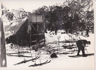
Wallace's Hut is the oldest surviving cattlemen's hut on the High Plains, built in 1889 by the three Wallace brothers - Arthur, William and Stewart. Their father David bought land at Kergunyah as well as grazing land on the banks of the Kiewa River, North East Victoria. Once the boys were old enough, the family followed the local squatters’ custom of taking their cattle up to the mountains for the spring and summer to fatten the mob, at the same time resting their home pastures. They decided to build a hut where they could shelter from the extreme mountain weather. The timber was cut from the forest about four hundred metres east of the hut, and the hearth stone was dragged in from Pretty Valley. The chimney had a base of rubble and above this iron sheeting on a timber frame. The slab walls were lined with hessian and later with tar-paper, and inside there was a bush table, sleeping platform and a rustic fire-side settle. The hut nestled among snow gums sheltered by a rocky outcrop. The names of the Wallace brothers were burnt into the tie-beams of the roof and at the back of the mantelpiece. The Wallace family’s lease expired in the late 1930s and the hut was bought by the State Electricity Commission to house staff on the High Plains and it became the first home of Toni and Skippy St. Elmo. The SEC covered the old shingles with iron, and later on the walls and chimney as well, and they added a lean-to. Wallace’s Hut is now owned by the Crown and maintained by Parks Victoria. It is on the Historic Buildings Register and is classified by the National Trust.This image is significant because it depicts an important heritage-listed structure and refuge for cattlemen and other travellers in Victoria's High Country.A black and white photograph of a skier outside of Wallace's Hut. Several sets of skis and poles are standing around and other skiers are in the background.wallace's hut, toni and skippy st. elmo, high country huts -
 Melton City Libraries
Document, Design of Dinner, c.1970
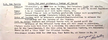
Melton Fire Brigade history In a letter to George Minns of 24th March 1942 from the Forests Commission the brigade was registered Class ‘F’ with the certificate of Registration N. 425. In December 1935 a public meeting was held with the purpose of forming a bush fire brigade. Constable Roy Corbett was elected Captain a position he held until 1941 and 1945 –1949. 1942 EW Barrie. 1st Lieut 2nd Lieut TL Barrie 1943 EW Barrie 2nd Lieut 1944 : : MELTON RURAL FIRE BRIGADE Established under CFA act 1944 1945- 1953 EW Barrie Apparatus Officer 1951- 1965 EW Barrie Captain 1967- 1979 EW Barrie elected Group Communication Officer of the Mt Cotterill Fire Brigades. RADIO In 1954 the Fire Brigade introduced 2 HF (high frequency) radios, one was installed in the Fire truck and the other in the Captains utility. 1956- 16th March Licence granted to the County Fire Authority Melton to establish a MOBILE transmitting and receiving station. Area of operation, Melton and District on the frequency (kc/s) 3836 for the exchange of messages relating to the fighting and prevention of fires during actual fires or periods of fire hazard with the CFA Bacchus Marsh base station VL3OX. 1958- 22nd May Commonwealth of Australia, Postmaster-General’s Department Special Licence No H 702 under the Wireless Telegraphy Act 1905-1950 is hereby transferred to Mr. E.W. Barrie, Captain, Melton Rural Fire Brigade to establish a MOBILE transmitting and receiving station. Call sign VL3 OX 6 and VL 3OX 7Group officer Bon Barrie's invitation to a Fire Brigade formal dinner emergency services -
 Melbourne Legacy
Slide, Operation Firewood - Red Gum Forest, Murray River, 1960s
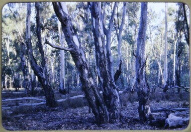
Colour slide of red gum trees in a forest near the Murray River. It was during Operation Firewood. Legatees would organise collection of wood from the country and distribute it to widows in metropolitan Melbourne. More photos show the cutting and loading of wood and delivery to widows in metropolitan Melbourne. Was with many other slides taken in the 1950s and 1960s. The slides have been photographed to make digital images and moved to archive quality sleeves. In many cases the original images were not well focussed and the digital image the best available.A record of Legacy helping widows by sourcing, supplying and delivering firewood. When open fires were the main source of heating, a load of firewood and help moving it, would have been very important to the widows.Colour slide of trees in a Red Gum forest during Operation Firewood in brown Anscochrome cardboard mount. Printed on reverse in red ink 'Processed by Verycolor photo labs. Melbourne, Victoria'.Printed on front in red ink 'Anscochrome / View from this side / Made in Australia'. Hand written on front 'Red gum trees / River Murry' in blue pen.operation firewood, trees, forest -
 Melbourne Legacy
Slide, Operation Firewood - Ready for pick up, 1960s
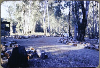
Colour slide of cut wood lying n a forest ready to be collected. It was during Operation Firewood. Legatees would organise collection of wood from the country and distribute it to widows in metropolitan Melbourne. Other slides show the cutting and loading of wood and delivery to widows in metropolitan Melbourne. Was with many other slides taken in the 1950s and 1960s. The slides have been photographed to make digital images and moved to archive quality sleeves. In many cases the original images were not well focussed and the digital image the best available.A record of Legacy helping widows by sourcing, supplying and delivering firewood. When open fires were the main source of heating, a load of firewood and help moving it, would have been very important to the widows.Colour slide of cut wood in a forest during Operation Firewood in brown Anscochrome cardboard mount.Printed on front in red ink 'Anscochrome / View from this side / Made in Australia'. Hand written on front 'Ready for pick up' in blue pen. Printed on reverse in red ink 'Processed by Verycolor photo labs. Melbourne, Victoria'.operation firewood, trees, forest, wood -
 Melbourne Legacy
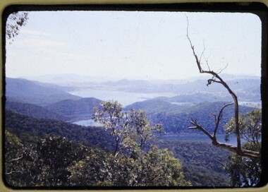
Slide, Operation Firewood - Eildon Reservoir, 1960s
Colour slide of a view of Lake Eildon from Big River Road. It was during Operation Firewood. Legatees would organise collection of wood from the country and distribute it to widows in metropolitan Melbourne. Other slides show the cutting and loading of wood and delivery to widows in metropolitan Melbourne. Was with many other slides taken in the 1950s and 1960s. The slides have been photographed to make digital images and moved to archive quality sleeves. In many cases the original images were not well focussed and the digital image the best available.A record of Legacy helping widows by sourcing, supplying and delivering firewood. When open fires were the main source of heating, a load of firewood and help moving it, would have been very important to the widows.Colour slide of a view of Lake Eildon during Operation Firewood in brown Anscochrome cardboard mount.Printed on front in red ink 'Anscochrome / View from this side / Made in Australia'. Hand written on front 'Eildon Reservoir from Big River Road' in blue pen. Printed on reverse in red ink 'Processed by Verycolor photo labs. Melbourne, Victoria'.operation firewood, trees, forest -
 Melbourne Legacy
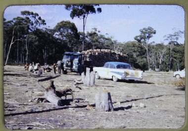
Slide, Operation Firewood - Euroa, 1960s
Colour slide of a semi trailer loaded with wood and a car in a forest near Euroa. It was during Operation Firewood. Legatees would organise collection of wood from the country and distribute it to widows in metropolitan Melbourne. Other slides show the cutting and loading of wood and delivery to widows in metropolitan Melbourne. Was with many other slides taken in the 1950s and 1960s. The slides have been photographed to make digital images and moved to archive quality sleeves. In many cases the original images were not well focussed and the digital image the best available.A record of Legacy helping widows by sourcing, supplying and delivering firewood. When open fires were the main source of heating, a load of firewood and help moving it, would have been very important to the widows.Colour slide of a semi trailer and a car in a forest near Euroa during Operation Firewood in brown Anscochrome cardboard mount.Printed on front in red ink 'Anscochrome / View from this side / Made in Australia'. Hand written on front 'Euroa group / Loaded up' in blue pen. Printed on reverse in red ink 'Processed by Verycolor photo labs. Melbourne, Victoria'.operation firewood, semi trailers, wood, forests -
 Melbourne Legacy
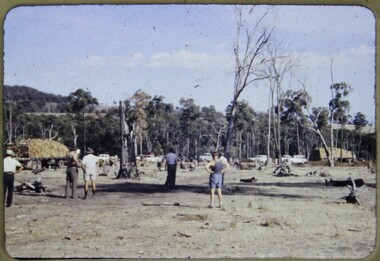
Slide, Operation Firewood - Euroa, 1960s
Colour slide of two semi trailers loaded with wood and several cars in a forest near Euroa. It was during Operation Firewood. Legatees would organise collection of wood from the country and distribute it to widows in metropolitan Melbourne. Other slides show the cutting and loading of wood and delivery to widows in metropolitan Melbourne. Was with many other slides taken in the 1950s and 1960s. The slides have been photographed to make digital images and moved to archive quality sleeves. In many cases the original images were not well focussed and the digital image the best available.A record of Legacy helping widows by sourcing, supplying and delivering firewood. When open fires were the main source of heating, a load of firewood and help moving it, would have been very important to the widows.Colour slide of two semi trailers and cars in a forest near Euroa during Operation Firewood in brown Anscochrome cardboard mount.Printed on front in red ink 'Anscochrome / View from this side / Made in Australia'. Hand written on front 'Transport off. Euroa - Firewood' in blue pen. Printed on reverse in red ink 'Processed by Verycolor photo labs. Melbourne, Victoria'.operation firewood, semi trailers, wood, forests -
 Melbourne Legacy
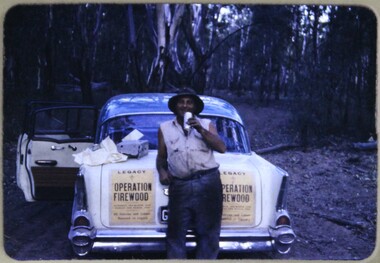
Slide, Operation Firewood - Picola, 1960s
Colour slide of a legatee beside a white and blue car in a forest near Picola, Victoria. The white and blue car features in other Operation Firewood photos. It has yellow 'Operation Firewood' posters stick to them. It was during Operation Firewood. Legatees would organise collection of wood from the country and distribute it to widows in metropolitan Melbourne. Other slides show the cutting and loading of wood and delivery to widows in metropolitan Melbourne. Was with many other slides taken in the 1950s and 1960s. The slides have been photographed to make digital images and moved to archive quality sleeves. In many cases the original images were not well focussed and the digital image the best available.A record of Legacy helping widows by sourcing, supplying and delivering firewood. When open fires were the main source of heating, a load of firewood and help moving it, would have been very important to the widows.Colour slide of a legatee beside a white and blue car during Operation Firewood in brown Anscochrome cardboard mount.Printed on front in red ink 'Anscochrome / View from this side / Made in Australia'. Handwritten 'The Bushman guide / Picola' in blue pen. Printed on reverse in red ink 'Processed by Verycolor photo labs. Melbourne, Victoria'.operation firewood, cars, forests -
 Forests Commission Retired Personnel Association (FCRPA)
Telescope used in FCV fire towers - ex military, c 1940s
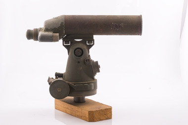
Victoria once had well over one hundred fire lookouts and firetowers. Fire lookouts, or observation posts, were often just a clearing on a hill or a vantage point, whereas firetowers were definite structures. Many were established by the Forests Commission Victoria (FCV) in the 1920s, but the network was expanded rapidly in response to recommendations of the Stretton Royal Commission after the 1939 Black Friday bushfires. When a fire or smoke was spotted from the tower a bearing was taken with the alidade and radioed or telephoned into the district office. It was then cross referenced with bearings from other towers on a large wall map to give a "fix" on the fire location Alidades and telescopes were used in the post war period but were replaced with a much simpler map table and reference string suspended from the centre of the tower cabin.Uncommon usageTelescope used in fire towers Ex military Kern Company NY Argus made in USA Adjustment lens, dials and focus ring Small spirit levelbushfire, forests commission victoria (fcv) -
 Forests Commission Retired Personnel Association (FCRPA)
Alidade - sight tube used in FCV fire towers, c 1940s
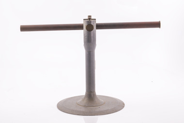
Victoria once had well over one hundred fire lookouts and firetowers. Fire lookouts, or observation posts, were often just a clearing on a hill or a vantage point, whereas firetowers were definite structures. Many were established by the Forests Commission Victoria (FCV) in the 1920s, but the network was expanded rapidly in response to recommendations of the Stretton Royal Commission after the 1939 Black Friday bushfires. When a fire or smoke was spotted from the tower a bearing was taken with the alidade and radioed or telephoned into the district office. It was then cross referenced with bearings from other towers on a large wall map to give a "fix" on the fire location Alidades and telescopes were used in the post war period but were replaced with a much simpler map table and reference string suspended from the centre of the tower cabin.Uncommon usageAlidade Sight TubeFCV and bearing markers on the alloy base. Very simple design. bushfire, forests commission victoria (fcv) -
 Forests Commission Retired Personnel Association (FCRPA)
Ventimeter, Wind anemometer in cardboard tube
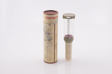
Bushfire behaviour is influenced by many factors including temperature, relative humidity (RH), forest type, fuel quantity and fuel dryness, topography and even slope. But wind has a dominant effect on the Rate of Spread (ROS), as well as fire size, shape and direction. Wind speed can be measured using a variety of anemometers. This simple hand-held Venitimer was made by Elvometer in Sweeden, probably in the 1960s, and was designed for principally for mariners. Some models have a compass in the handle to measure wind direction. The small inlet hole on the side is faced towards the wind and air pressure lifts small plastic disk inside. The upper tube is tapered so that as wind speed increases more air escapes and stronger winds are needed to raise the disk. Wind speed in MPH is read from the side of the clear plastic tube. The waterproof container has instructions on use and conversion scales. Simple and robust device.Hand- held wind anemometer Instructions on use on containerbushfire, forests commission victoria (fcv) -
 Forests Commission Retired Personnel Association (FCRPA)
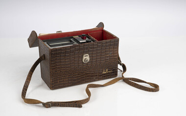
Portable UHF Radio - Sawtron / Kyodo, c 1980s
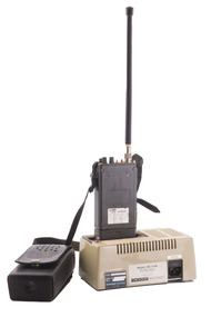
After the 1939 bushfires, the Forests Commission invested heavily in a radically new communications network. After suffering some inevitable delays due to the War, radio VL3AA switched into full operation in October 1945 proudly beaming out 200 watts across the State. But by today’s standards, the technology was primitive and the reception poor unless the user was on a high point somewhere. The radio signal was "line-of-sight" and bounced between fire towers and relay transmitters across the mountains back to the District offices. Rapid improvements in technology led to various models of bulky handheld portables with heavy batteries that always seemed to go flat. In fact, batteries were a constant impediment at bushfires. The more secure and versatile State Mobile Radio (SMR) digital trunk system came into operation in about 1995. Upgraded Tait Radios were purchased in 2014 after recommendations of the 2009 Bushfires Royal Commission. But it was the convergence of separate technologies such as 4G mobile phones, high-capacity and light-weight lithium batteries, Wi-Fi, the ever-expanding internet, cloud data storage, digital cameras, GPS, personal organisers and hundreds of supporting Apps into powerful smartphones and tablets which revolutionised bushfire communications from the mid-2000s.Portable UHF Radio with leather carrying case and strap. Charging station. Kyodo Model KC-1109 MOYHU Whitfieldbushfire, radios, forests commission victoria (fcv) -
 Forests Commission Retired Personnel Association (FCRPA)
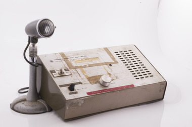
Base station radio with handset, Mid 1980s
After the 1939 bushfires, the Forests Commission invested heavily in a radically new communications network. After suffering some inevitable delays due to the War, radio VL3AA switched into full operation in October 1945 proudly beaming out 200 watts across the State. But by today’s standards, the technology was primitive and the reception poor unless the user was on a high point somewhere. The radio signal was "line-of-sight" and bounced between fire towers and relay transmitters across the mountains back to the District offices. The more secure and versatile State Mobile Radio (SMR) digital trunk system came into operation in about 1995. Upgraded Tait Radios were purchased in 2014 after recommendations of the 2009 Bushfires Royal Commission. But it was the convergence of separate technologies such as 4G mobile phones, high-capacity and light-weight lithium batteries, Wi-Fi, the ever-expanding internet, cloud data storage, digital cameras, GPS, personal organisers and hundreds of supporting Apps into powerful smartphones and tablets which revolutionised bushfire communications from the mid-2000s.Base station radio with handsetRC-4B Amalgamated Wireless Australiabushfire, radios, forests commission victoria (fcv) -
 Forests Commission Retired Personnel Association (FCRPA)
Sling Psychrometer
Bushfire behaviour is influenced by many factors including temperature, relative humidity (RH), forest type, fuel quantity and fuel dryness, topography and even slope. Wind has a dominant effect on the Rate of Spread (ROS), as well as fire size, shape and direction. Temperature and relative humidity have major impacts on fuel dryness and therefore upon the availability of fuel for combustion. The amount of fine fuel available can increase rapidly from nearly zero when fuel moisture content is more than 16% after rain or a heavy morning dew, to many tonnes per hectare as fuel dries out later in the day and the moisture content drops below 9%. This explosive escalation in the amount of available fuel can happen over a few hours on hot and windy days. A sling psychrometer is a simple device for determining air temperature and relative humidity. It contains two thermometers, one of which is covered with a wick saturated with ambient temperature liquid water. These two thermometers are called dry bulb and wet bulb. When the sling psychrometer is spun rapidly in the air, the evaporation of the water from the wick causes the wet bulb thermometer to read lower than the dry bulb thermometer. After the psychrometer has been spun long enough for the thermometers to reach equilibrium temperatures, the unit is stopped, and the two thermometers are quickly read. A psychrometric scale on the side of the instrument is then used to convert the dry bulb temperature TDB and the wet bulb temperature TWB into humidity information. The wet bulb temperature is approximately equal to the adiabatic saturation temperature. The thermometers fold back into the plastic handle when not in use. Used to measure temperature and relative humiditySling PsychrometerBACHARACH INSTRUMENTS - Pittsburg PAbushfire, forests commission victoria (fcv) -
 Forests Commission Retired Personnel Association (FCRPA)
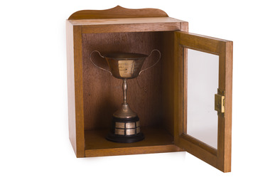
Award - Charles Watson Perpetual Trophy, North east division annual fire school - 1954 - 1962
Fire schools were an important pre-summer program for all Forests Commission staff and crews They were designed as refresher courses for existing staff and training of new staff on how to use pumps and hoses FCV Forest Divisions were made up of separate forest inter-district and competitions were held. The award was displayed prominently in either the winning district or kept in the divisional office Charles Watson was appointed as the Divisional Forester at Wangaratta in 1949, before retiring in 1960.Silver cup on stand in wooden display case with glass frontNames of winners 1954 - F Halloran & B Curren - Upper Ovens 1955 - L J Mitchell & J D Hallen - Ovens ? 1957 - K R O'Kane & R E Warren - Upper Murray 1958 - A P Davis & D G Craig - Delatite 1959 - K N Gibson & R W Handmer - Mansfield 1960 - L Reid & I F McLaughlin - Benalla 1962 - P Breen & G Treloar - Bright forests commission victoria (fcv) -
 Forests Commission Retired Personnel Association (FCRPA)
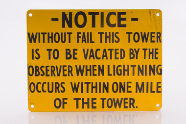
Fire tower warning sign
... Bushfire Forest Signs Forests Commission Victoria (FCV ...bushfire, forest signs, forests commission victoria (fcv) -
 Department of Energy, Environment and Climate Action
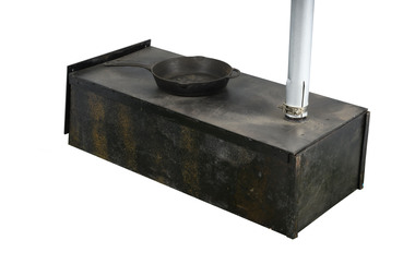
Aldershot Camp stove
... Used at fire basecamps Forests Commission Victoria (FCV ...Used at fire basecampsWood fire used at basecamps Metal plates fold flat for transportforests commission victoria (fcv), bushfire, camping equipment -
 Department of Energy, Environment and Climate Action
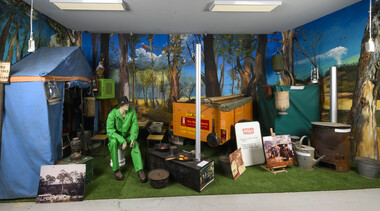
General View of fire basecamp - Altona Museum
Base campView of base camp equipment at the Altona Museumforests commission victoria (fcv), camping equipment, bushfire -
 Department of Energy, Environment and Climate Action
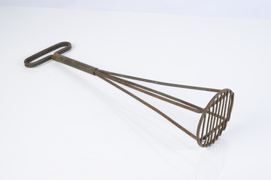
Food masher
... used at fire camps Forests Commission Victoria (FCV ...used at fire campsMetal food masherforests commission victoria (fcv), bushfire, camping equipment -
 Department of Energy, Environment and Climate Action
FCV presentation plaque and mould
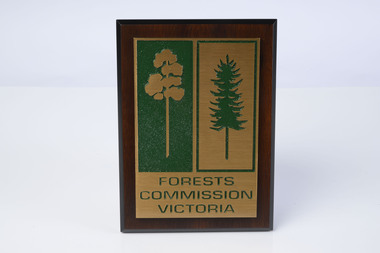
The wooden mould was originally made in the early 1980s by one of the crew in his spare time in East Gippsland (Bairnsdale maybe). It was passed it on to Ian Long and then Barrie Marsden at Altona. It was not made for any particular purpose other than just a copy of the iconic FCV logo. It sat in the office at Altona for a little while until one day Barry thought it could be used to cast a solid replica. The wooden mould was taken to a foundry in North Melbourne and three bronze replicas were cast and polished. One was used when the Chief Fire Officer, Bary Johnson, was retiring More were cast in brass and the plaques became a standard presentation item for retiring FCV personnel. The wooden mould eventually cracked and can no longer be used. Hand madeWooden mould and presentation plaqueforests commission victoria (fcv), forest signs -
 Department of Energy, Environment and Climate Action
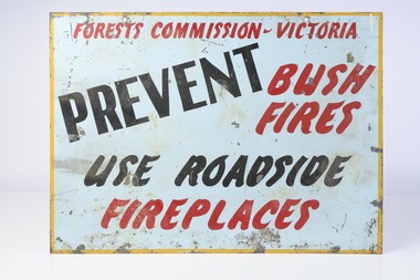
Fire prevention gallows signs (six double sided signs with different messages on each side)
... ) Bushfire Forest Signs Metal Fire awareness gallows signs Fire ...Bushfire awareness gallows signs were common features during the summer fire season and hung outside both FCV offices and on major roadways These six large metal signs have different text on each side and the message and lettering is simple enough to be read from a moving vehicle Metal Fire awareness gallows signsforests commission victoria (fcv), bushfire, forest signs -
 Department of Energy, Environment and Climate Action
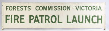
Fire patrol launch
... The Forests Commission once had a flotilla of small fire ...The Forests Commission once had a flotilla of small fire boats on the Gippsland Lakes, Lake Eildon and the Murray River which were used for fire patrol and suppression.Fire patrol launch signforests commission victoria (fcv), bushfire, forest signs -
 Department of Energy, Environment and Climate Action
Fire Finder
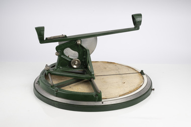
Victoria once had well over one hundred fire lookouts and firetowers. Fire lookouts, or observation posts, were often just a clearing on a hill or a vantage point, whereas firetowers were definite structures. Many were established by the Forests Commission Victoria (FCV) in the 1920s, but the network was expanded rapidly in response to recommendations of the Stretton Royal Commission after the 1939 Black Friday bushfires. When a fire or smoke was spotted from the tower a bearing was taken with the alidade and radioed or telephoned into the district office. It was then cross referenced with bearings from other towers on a large wall map to give a "fix" on the fire location. Alidades and telescopes were used in the post war period but were replaced with a much simpler map table and reference string suspended from the centre of the tower cabin. This "Fire Finder" was used in Canadian fire towers to identify the location of wildfires. The unique design was first developed by the British Columbia Forest Service (BCFS) in the early 1950s. Close examination of the map indicates that this particular Fire Finder may have been once used at Bluejoint Mountain lookout in Granby Provincial Park. This Fire Finder was a gift to Barry (Rocky) Marsden from the British Columbia Forest Service in the late 1980s in recognition of the close relationships that had been forged with the staff at the Altona Workshops over many decades. Fire Finders were originally painted black but this one was repainted green after it arrived at Altona. The BC Forest Service had a large facility where they manufactured Fire Finders and many other items of equipment, but in the 1980s it was shut down. Heavy cast iron circular object with a paper topographic map mounted on it. The metal dial and ruler works similar to a compass. The sight tube is used to determine the bearing and elevation of the fire on the map. This Fire Finder also sometimes known as an Alidade. Its a different design from the Osborne Fire Finder widely used in North American fire lookouts from the 1920s. British Columbia Forest Service. Model 62A. Serial Number 6308.bushfire -
 Department of Energy, Environment and Climate Action
Fire Finder
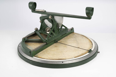
Victoria once had well over one hundred fire lookouts and firetowers. Fire lookouts, or observation posts, were often just a clearing on a hill or a vantage point, whereas firetowers were definite structures. Many were established by the Forests Commission Victoria (FCV) in the 1920s, but the network was expanded rapidly in response to recommendations of the Stretton Royal Commission after the 1939 Black Friday bushfires. When a fire or smoke was spotted from the tower a bearing was taken with the alidade and radioed or telephoned into the district office. It was then cross referenced with bearings from other towers on a large wall map to give a "fix" on the fire location. Alidades and telescopes were used in the post war period but were replaced with a much simpler map table and reference string suspended from the centre of the tower cabin. This "Fire Finder" was used in Canadian fire towers to identify the location of wildfires. The unique design was first developed by the British Columbia Forest Service (BCFS) in the early 1950s. Close examination of the map indicates that this particular Fire Finder may have been once used at Bluejoint Mountain lookout in Granby Provincial Park. This Fire Finder was a gift to Barry (Rocky) Marsden from the British Columbia Forest Service in the late 1980s in recognition of the close relationships that had been forged with the staff at the Altona Workshops over many decades. Fire Finders were originally painted black but this one was repainted green after it arrived at Altona. The BC Forest Service had a large facility where they manufactured Fire Finders and many other items of equipment, but in the 1980s it was shut down. Heavy cast iron circular object with a paper topographic map mounted on it. The metal dial and ruler works similar to a compass. The sight tube is used to determine the bearing and elevation of the fire on the map. This Fire Finder also sometimes known as an Alidade. Its a different design from the Osborne Fire Finder widely used in North American fire lookouts from the 1920s. British Columbia Forest Service. Model 62A. Serial Number 6308.bushfire -
 Department of Energy, Environment and Climate Action
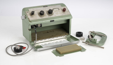
Relative Humidity Meter
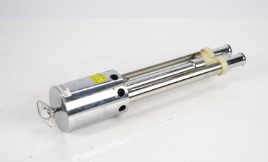
Bushfire behaviour is influenced by many factors including temperature, relative humidity (RH), forest type, fuel quantity and fuel dryness, topography and even slope. Wind has a dominant effect on the Rate of Spread (ROS), as well as fire size, shape and direction. Temperature and relative humidity have major impacts on fuel dryness and therefore upon the availability of fuel for combustion. The amount of fine fuel available can increase rapidly from nearly zero when fuel moisture content is more than 16% after rain or a heavy morning dew, to many tonnes per hectare as fuel dries out later in the day and the moisture content drops below 9%. This explosive escalation in the amount of available fuel can happen over a few hours on hot and windy days. This device is used for determining air temperature and relative humidity. It contains two thermometers, one of which is covered with a wick saturated with ambient temperature liquid water. These two thermometers are called dry bulb and wet bulb. Once the thermometers to reach equilibrium temperatures the two thermometers are quickly read. The figures are then used to convert the dry bulb temperature TDB and the wet bulb temperature TWB into humidity information. The wet bulb temperature is approximately equal to the adiabatic saturation temperature. Relative humidity meter in wooden box two stainless steel tubes contain wet and dry thermometers A small clock drives a fan motor in the base to circulate airforests commission victoria (fcv), weather, bushfire -
 Department of Energy, Environment and Climate Action
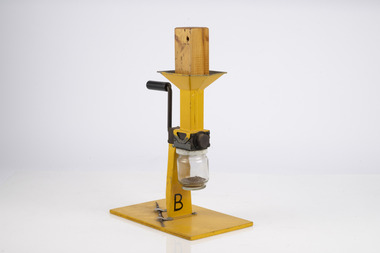
Fuel Mincer
Used to mince fuel samples to measure moisture content Representative samples of fuel such as bark, leaves, twigs etc were minced and the moisture measured The availability of fuel to burn depends largely on its moisture content. When it exceeds 20-25% not much will burn, whereas 12-15% is generally ideal for fuel reduction burning, but if the moisture content drops as low as 7-10% virtually everything will ignite, and fire behaviour becomes extreme. During the afternoon of the Ash Wednesday bushfires on 16 February 1983 fuel moisture contents were recorded at Stawell as low as 2.7%. Fine fuels like leaves and bark can rapidly absorb moisture after a shower of rain, or from the air when the Relative Humidity (RH) is high, and the temperature is low. Conversely, they can also dry out very quickly. So even though the overall fuel quantity in the forest doesn’t change, the fine fuel availability can increase rapidly from zero after rain to many tonnes per hectare as the fuel dries out. This can happen over a few hours on hot and windy days. Heavy fuels like logs on the ground take longer to dry out. Fuel mincer Made at Altona as an alternative design to the commercial Spong Mincer With wooden plug to push fuel into the mincer and glass jar to collect sampleforests commission victoria (fcv), bushfire, forest measurement -
 Department of Energy, Environment and Climate Action
Electric Fuel Mincer
Used to mince fuel samples to measure moisture content Representative samples of fuel such as bark, leaves, twigs etc were minced and the moisture measured The availability of fuel to burn depends largely on its moisture content. When it exceeds 20-25% not much will burn, whereas 12-15% is generally ideal for fuel reduction burning, but if the moisture content drops as low as 7-10% virtually everything will ignite, and fire behaviour becomes extreme. During the afternoon of the Ash Wednesday bushfires on 16 February 1983 fuel moisture contents were recorded at Stawell as low as 2.7%. Fine fuels like leaves and bark can rapidly absorb moisture after a shower of rain, or from the air when the Relative Humidity (RH) is high, and the temperature is low. Conversely, they can also dry out very quickly. So even though the overall fuel quantity in the forest doesn’t change, the fine fuel availability can increase rapidly from zero after rain to many tonnes per hectare as the fuel dries out. This can happen over a few hours on hot and windy days. Heavy fuels like logs on the ground take longer to dry out. Battery operated Fuel mincer. Plugs into 12 volt car cigarette lighter socket Adaption using parts from commercial food processor Made at Altona as an alternative design to the commercial Spong Mincer Glass jar to collect sampleforests commission victoria (fcv), bushfire, forest measurement -
 Department of Energy, Environment and Climate Action
Delton Moisture meter
Used to measure moisture content by electric current resistance Representative samples of fuel such as bark, leaves, twigs etc were minced and the moisture measured The availability of fuel to burn depends largely on its moisture content. When it exceeds 20-25% not much will burn, whereas 12-15% is generally ideal for fuel reduction burning, but if the moisture content drops as low as 7-10% virtually everything will ignite, and fire behaviour becomes extreme. During the afternoon of the Ash Wednesday bushfires on 16 February 1983 fuel moisture contents were recorded at Stawell as low as 2.7%. Fine fuels like leaves and bark can rapidly absorb moisture after a shower of rain, or from the air when the Relative Humidity (RH) is high, and the temperature is low. Conversely, they can also dry out very quickly. So even though the overall fuel quantity in the forest doesn’t change, the fine fuel availability can increase rapidly from zero after rain to many tonnes per hectare as the fuel dries out. This can happen over a few hours on hot and windy days. Heavy fuels like logs on the ground take longer to dry out. Commercial timber moisture meter used to measure fuelDCR9-Tforests commission victoria (fcv), bushfire, forest measurement -
 Department of Energy, Environment and Climate Action
Marconi Moisture meter
Used to measure fuel moisture content Representative samples of fuel such as bark, leaves, twigs etc were minced and the moisture measured The availability of fuel to burn depends largely on its moisture content. When it exceeds 20-25% not much will burn, whereas 12-15% is generally ideal for fuel reduction burning, but if the moisture content drops as low as 7-10% virtually everything will ignite, and fire behaviour becomes extreme. During the afternoon of the Ash Wednesday bushfires on 16 February 1983 fuel moisture contents were recorded at Stawell as low as 2.7%. Fine fuels like leaves and bark can rapidly absorb moisture after a shower of rain, or from the air when the Relative Humidity (RH) is high, and the temperature is low. Conversely, they can also dry out very quickly. So even though the overall fuel quantity in the forest doesn’t change, the fine fuel availability can increase rapidly from zero after rain to many tonnes per hectare as the fuel dries out. This can happen over a few hours on hot and windy days. Heavy fuels like logs on the ground take longer to dry out. Adaption of a commercial timber moisture meter measure fuelTF 933 Cforests commission victoria (fcv), bushfire, forest measurement