Showing 137 items matching "george farmers"
-
 Ballaarat Mechanics' Institute (BMI Ballarat)
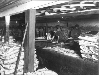
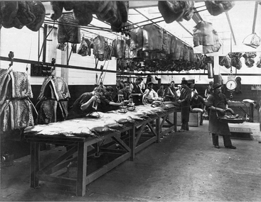
Portion of Curing Cellar No 2
... George Farmer... George Farmer Eureka St Ballarat East factory 1910 Portion ...This photograph is from the Max Harris Collection held by the Ballaraat Mechanics' Institute. Please contact BMI for all print and usage inquiries.ballarat, curing, cellar, george farmer, eureka st, ballarat east, factory, 1910 -
 Ballaarat Mechanics' Institute (BMI Ballarat)
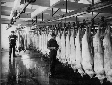
Portion of Hanging Room
... George Farmer... BMI for all print and usage inquiries. Ballarat pigs George ...This photograph is from the Max Harris Collection held by the Ballaraat Mechanics' Institute. Please contact BMI for all print and usage inquiries.ballarat, pigs, george farmer, eureka st, ballarat east, factory, 1910 -
 Ballaarat Mechanics' Institute (BMI Ballarat)
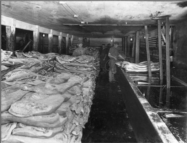
Portion of No 1 Cellar
... George Farmer... George Farmer Eureka St Ballarat East factory 1910 Portion ...This photograph is from the Max Harris Collection held by the Ballaraat Mechanics' Institute. Please contact BMI for all print and usage inquiries.ballarat, curing, cellar, george farmer, eureka st, ballarat east, factory, 1910 -
 Ballaarat Mechanics' Institute (BMI Ballarat)
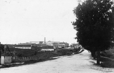
Rear of Factory (Joseph St)
... George Farmer... St George Farmer Eureka St Ballarat East factory 1910 Rear ...This photograph is from the Max Harris Collection held by the Ballaraat Mechanics' Institute. Please contact BMI for all print and usage inquiries.ballarat, factory, joseph st, george farmer, eureka st, ballarat east, factory, 1910 -
 Ballaarat Mechanics' Institute (BMI Ballarat)
Packing & Branding Room
... George Farmer... branding George Farmer Eureka St Ballarat East factory 1910 Packing ...This photograph is from the Max Harris Collection held by the Ballaraat Mechanics' Institute. Please contact BMI for all print and usage inquiries.ballarat, packing, branding, george farmer, eureka st, ballarat east, factory, 1910 -
 Ballaarat Mechanics' Institute (BMI Ballarat)
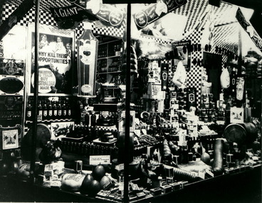
Shop Window detail
... george farmer... BMI for all print and usage inquiries. Shop window hams george ...This photograph is from the Max Harris Collection held by the Ballaraat Mechanics' Institute. Please contact BMI for all print and usage inquiries.shop, window, hams, george farmer, war -
 Port Melbourne Historical & Preservation Society
Letter - Applications for positon of Dog Registration Officer, Port Melbourne Council, Documents - letters, 1919
May 2016 David THOMPSON compiled the attached alphabetical list, including names and addresses service in WWI status and blue number. Port Melbourne applicants have been added to the WWI Centenary Project website A file of mostly handwritten applications and references for position of Dog Registration Officer, Meter Reader and Assistant Collector, Port Melbourne Council 1919. Over 100 applications from all over Victoria, many from Returned Soldiers since the advert in the Standard newspaper for the position stated that they were to be given preference. Sydney R C CARNS from Evans Street, a Returned Soldier who has lost his right hand during the war, was the successsful applicant according to a report in the Standard. Others from Port Melbourne who applied were James Gilbert ADAIR, Leslie Warner CASEY, Thomas William CLELAND, John COOK, Robert Dunbar, Vincent EDWARDS, Clarence Rupbert FARMER, Walter GOTZ, J W HART, Sydney Hercules HOLMES, William Thomas HOWLETT, John KING, Thomas P LACEY, John LUMSDEN, George MA?, W WEST and J C WILMOT. 112 letters in 3 batches, applications have large blue numbers added.local government - town of port melbourne, war - world war i, workers, utilities - electricity, domestic life - pets and pests, james gilbert adair, sydney r c carns, leslie walter casey, thomas william cleland, john cook, robert dunbar, vincent 'ben' edwards, clarence rupert farmer, walter gotz, j w hart, sydney hercules holmes, william thomas howlett, john king, thomas p lacey, john lumsden, w west, l c wilmot, arthur victor heath, town clerks, dogs -
 Bendigo Historical Society Inc.
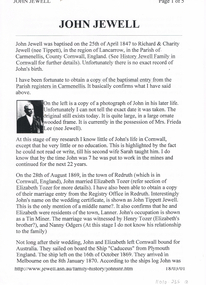
Document - LONG GULLY HISTORY GROUP COLLECTION: JOHN JEWELL
Five typed pages outlining the life of John Jewell from his birth in Cornwall to his marriages, immigration to Australia and his living in Ballarat, North Queensland and then to Bendigo where he worked at the Kentish Mine and was later the Manager. He also managed the Carlisle and Unity Batteries, was involved in a number of organisations and lent large sums of money to the Methodist Church in McIntyre Street Bendigo. There is a photo of John in his later life, one of his houses, John surrounded by 7 of his Grandchildren. and his headstone.bendigo, history, long gully history group, the long gully history group - john jewell, richard jewell, charity jewell (nee tippett), history of jewell family in cornwall, mrs frieda lee (nee jewell), sarah jewell, elizabeth tozer, john tippett jewell, henry tozer, nanny odgers, 'cadeueus', william john jewell, elizabeth jewell, john jewell, richard james jewell, kentish mine, george henry jewell, sarah ann clark, frederick albert victor jewell, william leslie norman jewell, mr j b watson, carlisle company, john jewell junior, carlisle battery, unity battery, the bendigonian 6/7/1909, long gully imperial football club, mining managers association, star of eaglehawk i.o.o.f., hopetoun band, carlisle mine cricket club , bell's reef co maldon, long gully fire brigade, dr simmonds, lanner, white hills cemetery, r bennetts, j cox, w arkinstall, w steen, g cox, t delchuray, mr a hicks mlc, mr w verece, messrs norris and son, passby mine, ah poo & co (workers of the sand), mr w farmer -
 Bendigo Historical Society Inc.
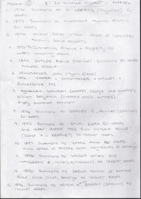
Document - CONNELLY, TATCHELL, DUNLOP COLLECTION: LEGAL PAPERS, 1894 - 1903
Document. Various legal papers. 1 - 1894 - Summons to Legard Mr (Raywood) for debts. 2 - 1895 - Summons to McNamara Thomas Francis for debts. 3 - 1894 - Wilson Sarah, widow. Sheet of liabilities. Menhons Roberts David. 4 - 1891-93 - Commercial Finance & Property Co. Letters concerning above. 5 - 1895 - Butler Pierce (Chemist). Summons for debts. Includes account. 6 - 1896 - Schumacker John, (Myers Creek). Carter v Schumacker & Walley & Racecourse Coy. 7 - Agreement between Chaffey George and Chaffey William Benjamin (Chaffey Bros Limited ). Empty published document. 8 - 1896 - Summons to Bracey G, Farmer (Barmah) for debts.cottage, miners, connelly, tatchell & dunlop, legard mr, mcnamara thomas francis, commercial finance & property co., butler pierce, schumacker john, carter, walley, racecourse coy, chaffey george, chaffey william benjamin, chaffey bros limited, bracey g -
 Bendigo Historical Society Inc.
Document - CONNELLY, TATCHELL, DUNLOP COLLECTION: LEGAL PAPERS, 1887 to 1899
Document. Various legal documents. 1 - 1899 - Letter in envelope marked Travers Mrs. Account from Connelly, Tatchell & Dunlop to Mrs Travers (Toorak) Re costs Lowndes. 2 - 1898 - Envelope marked Mrs M A Rosel (Leitchville). Account from Connelly, Tatchell & Dunlop Solicitors to Mrs M A Rosel for costs. 3 - Envelope marked Messrs Phillips & Tatchell. (i) 1897 - Account to Messrs Phillips & Tatchell - Executors of the Will of Thomas Tatchell, deceased for costs. (ii) Contains also the Estate of Thomas Tatchell. (iii) 1899 - Account to T Phillips Esq - Executor of the Estate of T Tatchell deceased for costs. 4 - Envelope marked Mr W Bockholt Farmer Colbinabbin 1899. Account to Mr W Bockholt for costs. 5 - 1887 - 1889 - Cheque payments paid into the Bank of Victoria. Paid to Thomas Jefferson Connelly by Curnow J, Holiday C, Frost William T, Dunlop George.cottage, miners, connelly, tatchell & dunlop, mrs travers, lowndes, mrs m a rosel, phillips & tatchell, tatchell thomas, buckholt mr w, bank of victoria, connelly thomas jefferson, curnow j, holliday c, frost william t, dunlop george -
 Bendigo Historical Society Inc.
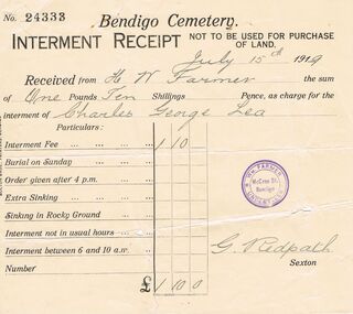
Document - LEA FAMILY COLLECTION: DOCUMENT
... for the Interment of Charles George Lea. Received from W. Farmer. G. Redpath ...Interment Receipt from the Bendigo Cemetery for the Interment of Charles George Lea. Received from W. Farmer. G. Redpath Sexton.person, individual, interment certificate, lea family documents, bendigo cemetry interment receipt no 24333, h w farmer, charles george lea, g redpath -
 Bendigo Historical Society Inc.
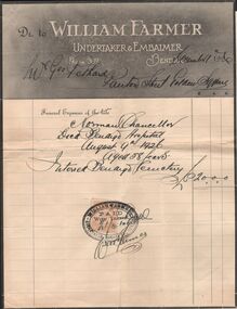
Document - LYDIA CHANCELLOR COLLECTION: NORMAN CHANCELLOR
A docket to William Farmer Undertaker & Embalmer with a list of the funeral expenses involved in the death of Mr. Norman Chancellor and paid for by Mr. George Pethard. 11/12/1926.cemetery, norman chancellor, lydia chancellor collection, collection, bendigo, mr. george pethard, mr. norman chancellor, death, interrment, funeral, business, finance, male, cemetery, william farmer -
 City of Ballarat
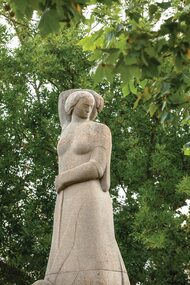
Sculpture - Public Artwork, George Allen, Mother Earth by George Allen, 1952
Mother Earth was created by modernist era sculptor George Allen. It is located in the western median strip at the intersection of Sturt and Raglan Streets. Made from Hawksbury stone on a granite base, the sculptor has created a female figure as the centrepiece, with two reliefs figures at the front and rear depicting a miner and a farmer. The work was created in commemoration of Mr Frank Pinkerton, an esteemed local lawyer in Ballarat. George Allen won the commission to design and execute the Pinkerton Statue in open competition in 1949. The statue is a significant work of one of Victoria's leading sculptors of the mid twentieth century, and controversy at the time surrounding its installation reflects the general attitude of the period to progressive public sculpture.Mother Earth was classified as regionally significant by the National Trust in 2003. The statement of significance below ha been provided by the National Trust, Victoria: The Pinkerton Statue by George Allen is of a simplified female figure which symbolises 'Earth', with smaller figures representing Mining and Agriculture carved in bas-relief at its base. The statue is carved in Hawkesbury Freestone and mounted on a granite plinth. It is located in a prominent position in central Ballarat. The statue in commemoration of Mr. Frank Pinkerton, an esteemed local lawyer, erected in Ballarat in 1952 is significant for aesthetic and social reasons at a Regional level. The statue is a significant example of the work of one of Victoria's leading sculptors of the mid twentieth century, and the controversy at the time surrounding its installation reflects the general attitude of the period to progressive public sculptures. George Allen won the commission to design and execute the Pinkerton Statue in open competition in 1949 against a large group of his peers. Following this. Allen was again successful in another major competition to design the National War Memorial for the Forecourt of the Shrine of Remembrance in Melbourne in 1951. Allen chose to work in a 'symbolic' manner using simplified forms with little detail, and relying on the strength of composition, 'boldness of statement' and the consideration of material for impact. Because of its lack of realism the Pinkerton Statue engendered much controversy, particularly within the popular press at the time, although it was generally appreciated in artistic circles. Allen had travelled extensively in Europe in the late 1930's, but his work mainly reflected influences from early modem sculptors in the United Kingdom such as Frank Dobson and Eric Gill. The Pinkerton Statue was the first example of modem sculpture to be erected in Ballarat and is an excellent example Allen's own work and the changing artistic culture of the period. Allen himself said that it reflected the "spirit of the time". A large Hawkesbury Freestone statue of a female figure and smaller figures representing Mining and Agriculture carved in bas-relief at its base. The statue is mounted on a granite plinth.CENTRAL FIGURE EARTH EMERGING FROM RELIEF FIGURES REPRESENTING THE INDUSTRIES OF MINING AND AGRICULTURE.pinkerton, mother earth -
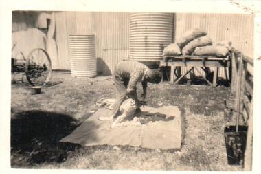 Hume City Civic Collection
Photograph
... davis road farmers shearers george evans collection on back ...A black and white photograph of a man shearing a sheep with shears in a farmyard with water tanks in the background with a stack of feed bags. The property if Bayview Farm, Davis Road, Diggers Rest.on back: BAYVIEW / DAVIS ROAD / DIGGERS RESTcullinan, uraina, eileen, diggers rest, bayview farm, chris, davis road, farmers, shearers, george evans collection -
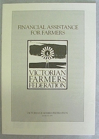 National Wool Museum
Booklet, Financial Assistance for Farmers
... Farmers Federation about financial assistance for farmers ...Information booklet produced by the Victorian Farmers Federation about financial assistance for farmers.Information booklet produced by the Victorian Farmers Federation about financial assistance for farmers.agriculture - industrial relations, victorian farmers federation, woods, mr george -
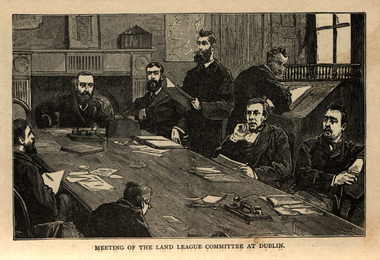 Ballarat and District Irish Association
Image, Land League Committee Meeting, Dublin, 1864
The Irish National Land League (Irish: Conradh na Talún) was an Irish political organisation of the late 19th century which sought to help poor tenant farmers. Its primary aim was to abolish landlordism in Ireland and enable tenant farmers to own the land they worked on. The period of the Land League's agitation is known as the Land War. Within decades of the league's foundation, through the efforts of William O'Brien and George Wyndham (a descendant of Lord Edward FitzGerald), the 1902 Land Conference produced the Land (Purchase) Act 1903 which allowed Irish tenant farmers buy out their freeholds with UK government loans over 68 years through the Land Commission (an arrangement that has never been possible in Britain itself). For agricultural labourers, D.D. Sheehan and the Irish Land and Labour Association secured their demands from the Liberal government elected in 1905 to pass the Labourers (Ireland) Act 1906, and the Labourers (Ireland) Act 1911, which paid County Councils to build over 40,000 new rural cottages, each on an acre of land. By 1914, 75% of occupiers were buying out their landlords, mostly under the two Acts. In all, under the pre-UK Land Acts over 316,000 tenants purchased their holdings amounting to 15 million acres (61,000 km2) out of a total of 20 million acres (81,000 km2) in the country. Sometimes the holdings were described as "uneconomic", but the overall sense of social justice was undeniable. (http://en.wikipedia.org/wiki/Irish_National_Land_League, accessed 21 January 2014) The Irish National Land League was founded at the Imperial Hotel in Castlebar, the County town of Mayo, on 21 October 1879. At that meeting Charles Stewart Parnell was elected president of the league. Andrew Kettle, Michael Davitt, and Thomas Brennan were appointed as honorary secretaries. This united practically all the different strands of land agitation and tenant rights movements under a single organisation. The two aims of the Land League, as stated in the resolutions adopted in the meeting, were: ...first, to bring out a reduction of rack-rents; second, to facilitate the obtaining of the ownership of the soil by the occupiers. That the object of the League can be best attained by promoting organisation among the tenant-farmers; by defending those who may be threatened with eviction for refusing to pay unjust rents; by facilitating the working of the Bright clauses of the Irish Land Act during the winter; and by obtaining such reforms in the laws relating to land as will enable every tenant to become owner of his holding by paying a fair rent for a limited number of years. Charles Stewart Parnell, John Dillon, Michael Davitt, and others including Cal Lynn then went to America to raise funds for the League with spectacular results. Branches were also set up in Scotland, where the Crofters Party imitated the League and secured a reforming Act in 1886. The government had introduced the first ineffective Land Act in 1870, then the equally inadequate Acts of 1880 and 1881 followed. These established a Land Commission that started to reduce some rents. Parnell together with all of his party lieutenants, including Father Eugene Sheehy known as "the Land League priest", went into a bitter verbal offensive and were imprisoned in October 1881 under the Irish Coercion Act in Kilmainham Jail for "sabotaging the Land Act", from where the No-Rent Manifesto was issued, calling for a national tenant farmer rent strike which was partially followed. Although the League discouraged violence, agrarian crimes increased widely. Typically a rent strike would be followed by evictions by the police, or those tenants paying rent would be subject to a local boycott by League members. Where cases went to court, witnesses would change their stories, resulting in an unworkable legal system. This in turn led on to stronger criminal laws being passed that were described by the League as "Coercion Acts". The bitterness that developed helped Parnell later in his Home Rule campaign. Davitt's views were much more extreme, seeking to nationalise all land, as seen in his famous slogan: "The land of Ireland for the people of Ireland". Parnell aimed to harness the emotive element, but he and his party preferred for tenant farmers to become freeholders on the land they rented, instead of land being vested in "the people".(http://en.wikipedia.org/wiki/Irish_National_Land_League, accessed 21 January 2014)Image of a number of men sitting around a table. They are members of the Land League Committee during a meeting in Dublin.ballarat irish, land league, land league committee, dublin -
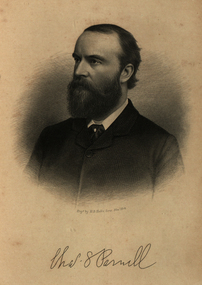 Ballarat and District Irish Association
Image, Charles Parnell, c1864, 1864
Parnell was an Irish nationalist and statesman who led the fight for Irish Home Rule in the 1880s. Charles Stewart Parnell was born on 27 June 1846 in County Wicklow into a family of Anglo-Irish Protestant landowners. He studied at Cambridge University and was elected to parliament in 1875 as a member of the Home Rule League (later re-named by Parnell the Irish Parliamentary Party). His abilities soon became evident. In 1878, Parnell became an active opponent of the Irish land laws, believing their reform should be the first step on the road to Home Rule. In 1879, Parnell was elected president of the newly founded National Land League and the following year he visited the United States to gain both funds and support for land reform. In the 1880 election, he supported the Liberal leader William Gladstone, but when Gladstone's Land Act of 1881 fell short of expectations, he joined the opposition. By now he had become the accepted leader of the Irish nationalist movement. Parnell now encouraged boycott as a means of influencing landlords and land agents, and as a result he was sent to jail and the Land League was suppressed. From Kilmainham prison he called on Irish peasants to stop paying rent. In March 1882, he negotiated an agreement with Gladstone - the Kilmainham Treaty - in which he urged his followers to avoid violence. But this peaceful policy was severely challenged by the murder in May 1882 of two senior British officials in Phoenix Park in Dublin by members of an Irish terrorist group. Parnell condemned the murders. In 1886, Parnell joined with the Liberals to defeat Lord Salisbury's Conservative government. Gladstone became prime minister and introduced the first Irish Home Rule Bill. Parnell believed it was flawed but said he was prepared to vote for it. The Bill split the Liberal Party and was defeated in the House of Commons. Gladstone's government fell soon afterwards.(http://www.bbc.co.uk/history/historic_figures/parnell_charles.shtml, accessed 21 January 2014) The Irish National Land League (Irish: Conradh na Talún) was an Irish political organisation of the late 19th century which sought to help poor tenant farmers. Its primary aim was to abolish landlordism in Ireland and enable tenant farmers to own the land they worked on. The period of the Land League's agitation is known as the Land War. Within decades of the league's foundation, through the efforts of William O'Brien and George Wyndham (a descendant of Lord Edward FitzGerald), the 1902 Land Conference produced the Land (Purchase) Act 1903 which allowed Irish tenant farmers buy out their freeholds with UK government loans over 68 years through the Land Commission (an arrangement that has never been possible in Britain itself). For agricultural labourers, D.D. Sheehan and the Irish Land and Labour Association secured their demands from the Liberal government elected in 1905 to pass the Labourers (Ireland) Act 1906, and the Labourers (Ireland) Act 1911, which paid County Councils to build over 40,000 new rural cottages, each on an acre of land. By 1914, 75% of occupiers were buying out their landlords, mostly under the two Acts. In all, under the pre-UK Land Acts over 316,000 tenants purchased their holdings amounting to 15 million acres (61,000 km2) out of a total of 20 million acres (81,000 km2) in the country. Sometimes the holdings were described as "uneconomic", but the overall sense of social justice was undeniable. (http://en.wikipedia.org/wiki/Irish_National_Land_League, accessed 21 January 2014) The Irish National Land League was founded at the Imperial Hotel in Castlebar, the County town of Mayo, on 21 October 1879. At that meeting Charles Stewart Parnell was elected president of the league. Andrew Kettle, Michael Davitt, and Thomas Brennan were appointed as honorary secretaries. This united practically all the different strands of land agitation and tenant rights movements under a single organisation. The two aims of the Land League, as stated in the resolutions adopted in the meeting, were: ...first, to bring out a reduction of rack-rents; second, to facilitate the obtaining of the ownership of the soil by the occupiers. That the object of the League can be best attained by promoting organisation among the tenant-farmers; by defending those who may be threatened with eviction for refusing to pay unjust rents; by facilitating the working of the Bright clauses of the Irish Land Act during the winter; and by obtaining such reforms in the laws relating to land as will enable every tenant to become owner of his holding by paying a fair rent for a limited number of years. Charles Stewart Parnell, John Dillon, Michael Davitt, and others including Cal Lynn then went to America to raise funds for the League with spectacular results. Branches were also set up in Scotland, where the Crofters Party imitated the League and secured a reforming Act in 1886. The government had introduced the first ineffective Land Act in 1870, then the equally inadequate Acts of 1880 and 1881 followed. These established a Land Commission that started to reduce some rents. Parnell together with all of his party lieutenants, including Father Eugene Sheehy known as "the Land League priest", went into a bitter verbal offensive and were imprisoned in October 1881 under the Irish Coercion Act in Kilmainham Jail for "sabotaging the Land Act", from where the No-Rent Manifesto was issued, calling for a national tenant farmer rent strike which was partially followed. Although the League discouraged violence, agrarian crimes increased widely. Typically a rent strike would be followed by evictions by the police, or those tenants paying rent would be subject to a local boycott by League members. Where cases went to court, witnesses would change their stories, resulting in an unworkable legal system. This in turn led on to stronger criminal laws being passed that were described by the League as "Coercion Acts". The bitterness that developed helped Parnell later in his Home Rule campaign. Davitt's views were much more extreme, seeking to nationalise all land, as seen in his famous slogan: "The land of Ireland for the people of Ireland". Parnell aimed to harness the emotive element, but he and his party preferred for tenant farmers to become freeholders on the land they rented, instead of land being vested in "the people".(http://en.wikipedia.org/wiki/Irish_National_Land_League, accessed 21 January 2014)Image of bearded man known as Charles Stewart Parnellballarat irish, parnell, charles parnell, home rule -
 Bendigo Historical Society Inc.
Document - MARY ANNE MITCHELL COLLECTION CAMPBELL, CONNELLY & CO RECEIPTS, 1924-1939
Mary Anne Mitchell Collection Local Bendigo Business Receipts dating from 1924-1939. Businesses include: Campbell, Connelly & Co. Pty. Ltd. Ironmongers, Plumbers & Sewerage Contractors of Sheet Metal Goods; The Northern Seed Supply Co. Seed & Service Station; Gerrand, King & Son, Wholesale Fruiterer's & Commission Agents; Myer's Bendigo Pty Ltd. Drapers & Outfitters; Foggitt Jones Pty Ltd. Ham & Bacon Curers Central Provision Merchants & Bendigo Bacon Factory; W.J.Knight Late Knight & Wilkinson Wheelwright, General Blacksmith, Wagon & Lorry Builder, Motor Body Builders; D.Whyte's Farmers Cash Store Pty. Ltd Wholesale & Retail Grocers; Harol Pettit Used Cars; Whitelock & Carter Tailors, Mercers, Hatters & Bootmen Specialists in Ladies' Hosiery; W.Lewis Williams Chemist; J.C. Morrison Carriage Builder & Vehicle Manufacturer; Stilwell's Complete House Furnishers; Matthew Bros. General Drapers, Specialists in Men's Clothing, Mercery Manchester, Childs, Ladies'Wear etc; George Bennett Arcade Store Crockery, Glasswear, Ironmongery, Stationery, Toys; Chandlers'Hardware Stores; J.H. Curnow & Son Farm, Dairy Produce & Furniture Salesmen Fire & Livestock Insurance Merchants Bendigo Auction Rooms; Hume & Iser, Pty. Ltd. Timber & Iron Merchants; Warren's Drapers, Milliners, Outfitters, etc; Cocking's Bendigo Drapers Manchester, Dresses, Clothing, Mercery, Underclothing & Millinery; Hartley's (J.L. Shoosmith) Bicycle, Motorcycle, Motor, Sporting & Radio Store; Williams The Shoemen Pty Ltd; Walter A. Reynell & Co. Stock & Station Agents;bendigo, history, bendigo businesses -
 Bendigo Historical Society Inc.
Document - HERITAGE REPORT: FORMER POLICE STATION AND QUARTERS: CALIFORNIA GULLY
Seventeen page Heritage Place Report on the Former California Gully Police Station at 15 Thorpe Street, California Gully. It is the former police station and quarters, former timber stables and timber cottage residence demolished and horse paddock on separate title. Report includes a Statement of Significance, Place History (History of the Area), Policing California Gully Goldfields, History of the Buildings, Chronology of Ownership, Rate Books 1858, - 1867 - 1868, 1895 Borough of Eaglehawk Rates, 1922 Voters Roll, 1952 & 1962 Sands & McDougall Directory Thorpe St California Gully, Comparable Examples, Secondary Sources, Description Conservation Policy Guidelines (Specific), Physical Conditions, Physical Description 1, Map of Early Photo Location, Bendigo Parish Plan circa 1870, Certificate of Title 1950 & 1960. Pge 14 has plans, maps and an aerial photo of 15 Thorpe Street. Page 15 has an aerial photo of 15 Thorpe Street, California Gully with Allotment Size. Page 16 & 17 has photos.heritage, heritage report - former police station and quarters - california gully, city of greater bendigo, wilson & ass, butler, amanda jean, johnson reef shafts no 1 & 2, rose of denmark, princess dagmar, bendigo amalgamated goldfields company, captain frederick standish, royal irish constabulary, e thorpe, campbell, taylor, watson, brown, hosken, mckowne, mcqualter, parker, hicks, eaglehawk municipal council, victorian police force, d bannear, historic mining sites in the sandhurst eaglehawk and raywood mining divisions, department of conservation and natural resources, joshua thorpe, thorpe & co, johnson & co, william thorn, michael thomas, james murdock, edward c brown, francis youlden, gold escort, water police, mounted police, city police (melbourne), geelong police, gold fields police, rural bench constabulary, the people's force, robert haldane, n wild, streets of the borough of eaglehawk, police registration act, william henry mitchell, camp hotel, j o c nieman, j m catarach, g w hosken, margaret hosken nee mckown, majorie alice mcqualter, kellie anne mcqualter, adam joseph doolan, mr hicks, sands & mcdougall, hill george, meeking howard, mcewan frank a, jinks stanley, mccaig mrs eleanor, gordon john l, mcqualter mrs adeline, maher william l, raynor robert, flack john p, whitehead miss a, sang george t, linddsay john p, dyer henry, jackman george a, tibbetts mrs s a, hosken mrs margaret winifred nee mckowne, chaplin frank w, wilson c e, wright george, miller g a, sheyhill basil hugh, marshall r, miles j h, parker w b, barkla w g, nicholls les, cartledge clifford william, cole charles basil, farmers citizens trustees co, bev hanson -
 National Wool Museum
Currency - One Pound Note, John Ash, 1938 - 1948
John Ash succeeded Thomas Harrison as the Australian Note Printer in 1927 and oversaw the printing of a new series of banknotes, known as the Ash Series. First issued between 1933 and 1934, the new banknotes sought to improve the currency's resistance to counterfeiting. A special watermark was created to increase the security of the new series. Shaped as a medallion, the watermark showed the profile of Edward, the Prince of Wales. A new portrait of the King was also introduced, depicting him frontally rather than in profile as he had appeared in the prior banknotes of the Harrison Series (1923-1925). The back of each denomination contained an individual vignette that reflected a sector of the country's economy. The wool and agricultural industries were represented, as they had been in the first series of the nation's banknotes (1913-1914), and they were joined by manufacturing and commerce. The prominent British sculptor, Paul Montford, contributed to the design of the new series. Recognised for his sculptural works on the exterior of Melbourne's Shrine of Remembrance, Montford was commissioned to produce relief sculptures that formed the basis of the banknotes' vignettes. His sculptures were translated into wash drawings by Frank Manley, the artist and engraver for the Commonwealth Bank's Note Printing Branch. Manley accentuated the sculpture's three-dimensional qualities with deep shadows and touches of illusionism. A sheep in Montford's pastoral scene, for example, stands forward from the frame as if entering the viewer's space to escape branding and Manley preserves this visual conceit in his drawing. Whereas the printing of the previous series of Australian banknotes had been criticised for its poor definition, the sculptural basis of the Ash Series clarified the banknotes' imagery. During a period of record unemployment, the scenes emphasised the strength of the human figure in gestures of labour, evoking classical, heroic qualities in their poses. The sculptural forms suggested stability in the turbulence of the Great Depression and imparted a sense of solidity to paper currency. - museum.rba.gov.auCommonwealth of Australia paper one pound note in green and white tones depicting graphics and text. The obverse has a framed design with a blank portal to the left and King George VI in the right portal. The centre shows the Australian Coat of Arms, serial number, and detail over one pound symbol on a mosaic background, with signatories below. The reverse features a framed pastoral scene with farmers tending sheep, with a blank portal to the right.Obverse: ONE / 1 / 1 / ONE / COMMONWEALTH OF AUSTRALIA / K / 58 / 790230 / K / 58 / 790230 / This Note is legal tender for / ONE POUND / in the Commonwealth and in all / Territories under the control of the / Commonwealth. / [signature] / GOVERNOR / COMMONWEALTH BANK ON AUSTRALIA / [signature] / SECRETARY TO THE TREASURY Reverse: 1 /1 / 1 / 1 / PASTORALcurrency, money, pound note, pastoral scene, industry, commonwealth of australia, paul montford, king george vi, frank manly, john ash -
 Federation University Art Collection
Painting - Poster, Gilda Gude, 'It Pays To Read' by Gilda Gude, c1935
Gilda GUDE (1918-1996) Gilda Gude worked in various media throughout her career, favouring figure and flower studies. She attended the Ballarat Technical Art School during the early 1930s, and later the George Bell School. In 1938 Gilda Gude and Betty Brown, another Ballarat Technical Art School student, designed the flora carpet for the Ballarat Begonia Festival. This artwork was completed for a competition sponsored by the large art supply company Wiltshires. In 1952 Gude won the Royal Art Society Drawing Prize, and began lecturing at RMIT in 1861. This item is part of the Federation University Art Collection. The Art Collection features over 1000 works and was listed as a 'Ballarat Treasure' in 2007.art, artwork, gude, gilda gude, journal, poster, agriculture, farmer, reading -
 Bacchus Marsh & District Historical Society
Photograph, 'Plainside' Home and Farm of George Dickson Bacchus Marsh 1883
This property was located near Bacchus Marsh not far from the Racecourse. The photo shows members of the Dickson family. The oldest man on the left is possibly George Dickson who died in 1885 aged 92. The man second from the right is possibly the younger George Dickson who died aged 77 in 1900. The girl or the woman in the image is possibly Margaret Dickson.Small sepia unframed photograph on card with gold border framing photograph. Housed in the album, 'Photographs of Bacchus Marsh and District in 1883 by Stevenson and McNicoll'. In the foreground of the image are members of the Dickson family. In the background are yards, farm sheds, which are possibly milking sheds. Behind the sheds is the family home.On the front: Stevenson & McNicoll. Photo. 108 Elizabeth St. Melbourne. COPIES CAN BE OBTAINED AT ANY TIME. On the back: LIGHT & TRUTH inscribed on a banner surmounted by a representation of the rising sun. Copies of this Portrait can be had at any time by sending the Name and Post Office Money Order or Stamps for the amount of order to STEVENSON & McNICOLL LATE BENSON & STEVENSON, Photographers. 108 Elizabeth Street, MELBOURNE. stevenson and mcnicoll 1883 photographs of bacchus marsh and district, dickson family bacchus marsh, farmers, farms bacchus marsh -
 Melton City Libraries
Document, Minns Family Reunion, 2004
"A perpetual spring in the adjacent creek provided a steady supply of fresh water to the site on which the homestead is built. Although we can not be certain of the identity of the builder, the first stage of ‘The Willows’ homestead appears to have been constructed in the mid 1850s. The house is situated on Crown Allotment No.1 (No Section), Parish of Kororoit, an allotment of 5 acres 3 roods 4 perches. Although it had surveyed the land, the Crown did not offer it for sale until 22nd November 1861, at which time it was purchased by Charles March Williams. (Although the property is directly opposite and immediately adjacent to the Township of Melton, and was sold as ‘Suburban Allotment 33’, it was situated within the Shire of Braybrook rather than the Shire of Melton until 1917.) Considerable improvements had taken place on the land prior to the Crown sale. When CM Williams purchased the allotment in November 1861 he paid £23.5.0 for the land itself, and valued the improvements at £400. Even allowing for some exaggeration by Williams, this is an extremely high valuation for improvements, and must have included a house. Some local research has claimed that in 1858 Williams had taken over the interest of a Mr Parkinson in the property, and that Parkinson built the house upon taking possession of the land c.1855. It was definitely built by 1861, when a map shows a square building on the site marked as ‘House’. The property is important in the district for its association with the establishment of the pound. The district pound had been established in 1854, when George Scarborough of Mount Cottrell (Mt Cottrell Road, south of Greigs Road) was appointed pound-keeper. Scarborough resigned in 1857. The pound was moved to Melton following agitation from local farmers and Charles March Williams appointed pound-keeper on 26th April 1858. Williams, the son of a doctor, had been born in London. Reminiscences of local residents of the time, as recorded in the Express newspaper, note Williams’ success in breeding horses on the property. Sales of up to 60 guineas were noted. Whether this was from Williams’s own stock or from unclaimed pound stock is not made clear. Williams appeared before a government inquiry in 1860 and advocated registration of all stock brands in the State. Williams died in 1862 leaving a widow, Catherine, and five living children aged 15 years to five months. At the time of his death Williams had entered negotiations with one Matthew Devenish and had a mortgage of £100 on allotments 1 and 2, Parish of Kororoit. Catherine Williams was appointed pound-keeper on 2 September 1863, with her eldest son Charles as her assistant. Her tenure was short for on 22nd March 1864 George Minns senior paid Matthew Devenish £135 for allotments 1 and 2 Parish of Kororoit (considerably less than Williams had claimed the property was worth in 1861) and on the same day paid William Tullidge £45 for the adjoining allotments 3 and 4. In April 1867, James Ebden Minns, the newly married son of George senior became the owner of The Willows property having entered into a mortgage arrangement with his father to the extent of £200. At the time George Minns was residing in Kaarimba having left Melton in 1867 for a short trip to England and upon his return having taken up a selection in the Kaarimba district with his son Frederick who had a hotel licence there. James paid out the mortgage on 2-1-1873. James Minns was appointed pound-keeper in 1872; in 1885 the pound was moved elsewhere and Minns purchased the old pound site and added it to his farm. The Willows residence underwent a major change about this time. A two room extension, similar in style but with a lower elevation was added to the original rear of the house with a chimney matching the distinctive originals. Window arrangements did not match the original but became a feature of the façade when the new addition became the front of the building. Six buttresses were attached to the east and west walls of the old building, two to the south wall and the whole rendered with mortar to give the appearance of dressed stonework around the windows. Galvanized iron was placed over the shingles and a verandah added on three sides. By 1876 The Willows was the homestead for a thriving mixed farm of 340 acres of which 156 was rented from a H. Ruck. In October of that year the Australasian travelling reporter visited and reported on the property. In common with the nearly every other property in the district the farm had ‘recently’ (generally within the last two years) abandoned cultivation of crops, and turned over completely to cattle pasture. Butter making was the principal occupation of the farm, which had about 50 head of cattle, a large proportion of which were milking cows. The reporter also noted that a ‘large number of pigs are kept upon this farm and are found to be very profitable stock’. Their manure was used in an orchard and garden in which ‘large quantities of lucerne and prairie grass are grown for the use of stock when ordinary feed is scarce’. Two bores attached to deep brick lined wells supplied water for the house in addition to the farm. A commodious timber barn and necessary sheds had also been constructed. Access to the property was improved following the construction of the bluestone ford across the creek c.1887, when the recreation ground came into use. Prior to this date it may have been that the crossing referred to as ‘Mr Minns bridge’ was used. This appears to have been a flimsy structure and has but two references in Council reports in the Melton Express in the 1880’s. It is believed that in the late 1890’s a timber building was added near the rear of the building to house a kitchen, ablutions and laundry rooms and rooms for seasonal workers. This was attached to the house by means of a trellised walkway using the original front entry to the house (long since the back door). A photograph of this building appears in a local history of Melton. This was demolished in recent decades during the period when the house was tenanted (after the Minns family had left). James Minns son, George, took over the property following his marriage to Alice Walsh in 1903. James and Caroline moved into a house on the former JH Games property at the eastern end of Henry Street. George held the position of Shire Secretary for Melton for 40 years. He was a most prominent member of the community being Secretary to, among others, the Melton Coursing Club, the Shooting Club and the Cemetery Trust. He also rode with the hunting parties who sported across the Plains and were entertained at Mount Kororoit. George and Alice had one son, Norman who followed his father into local government and became Secretary of the Shire of Werribee completing a record term in this position. George retired to Werribee in 1951, where he died in 1965. The National Trust records note that James Ebden Minns and his sons were ‘leading men of the district, Justices of the Peace, and Shire Councillors’. It claims that Sir Thomas Bent was a frequent visitor. The Willows passed into the hands of George’s grandson, Bruce Minns and the property was let for a number of years. In the 1960s it became vacant and was subject to vandalism. Major structural problems arose with the part demolition of the roof, the loss of windows and doors and holes dug into and under the floorboards. The outbuildings were particularly targeted. Following widespread public support, the Shire of Melton purchased the house, with 3.75 acres of land, in 1972. In 1975 the Shire of Melton and the Melton and District Historical Society were successful in nominating the building for National Trust classification, and then the Australian Heritage Commission’s Register of the National Estate. The AHC particularly noted its ‘townscape importance’. It was envisaged that the farmhouse would form ‘a picturesque centrepiece to Melton’s planned … historical park, along with Dunvegan bluestone cottage … and similar structures as they become available.’ In a time of great Melton’s ‘satellite city’ development the Council spelt out its broader vision in its submission to the AHC: ‘Melton is destined to become, by the end of the present century, a city of between 75,000 and 100,000 people. Significant relics of the past, such as ‘The Willows’, regrettably will be rare in that situation. It is essential that sufficient tangible links with Melton’s pioneering days remain to promote in the new community a sense of history and continuity’. Under the direction of ‘The Willows’ Restoration Committee and consultant architect John Hitch, all outbuildings, with the exception of the garage and toilet, were demolished and the dwelling house restored. Finances were provided by the Shire of Melton and the National Estate Grants Program, and considerable amount of voluntary labour was provided by the local community. The orchard was removed, and remaining wooden buildings were relocated to provide an open vista for visitors to the Park. The property was furnished with donations from district families keen to preserve this example of pioneer life in the area. The Willows became the headquarters of the Melton and District Historical Society". Invitation to the family reunion at the Willowslocal identities, pioneer families -
 Melton City Libraries
Photograph, Barrie Collection, The Willows, 1973
Currently the headquarters of the Melton Historical Society, the Willows was built in 1855 by a farmer called Ralph Parkinson. In 1867, it was purchased and extended by James Ebden Minns. His son, George Minns, was given the property by his father in 1903, George was a council member of Melton Shire for 37 years and after he eft the area in 1951, the property became derelict. Although due to the support of the community, Melton Shire Council purchased the property in 1972 and to assist with the restoration, a group was established called the Willows Restoration Committee. The members included Chairman Cr Ed Gillespie, Lorraine Gillespie, Mr & Mrs Alan Reed, Ken Young, Bill Amor, Edna Barrie, Max Watson, Cr Jeff Robinson and Wendy Barrie.Restoration was completed in 1982.The Willows before restoration in 1973. This is the view of the front of the house and part of side wire fencing.council, local special interest groups, pioneer families, local architecture, local identities -
 Wodonga & District Historical Society Inc
Book - Three Parnaby Brothers from Whenby, Julie Walker and Judy Crook, 2000
... where he worked as a farmer and labourer. George died at Howlong ...This book documents the story of the Parnaby Brothers who migrated to Australia from Whenby in North Yorkshire, England via Natal in South Africa. They settled in the Wodonga district of Victoria. The dedication on page 3 of the book says "To George, William and Matthew Parnaby. We can only wonder at the adventurous spirit, courage and fortitude of the three brothers who arrived in this country with an ambition to better themselves and provide for their families." George arrived at Port Melbourne from Port Natal on 11 January 1864. On the same voyage was his brother William and a nephew Charles. George and his wife Rachel settled at Howlong on the Victoria/NSW border where he worked as a farmer and labourer. George died at Howlong on 26 JUne 1887. William and his son Charles settled in Albury. In 1869/70 he was listed as a property owner at Wooragee, including a house, farm and vineyard. William died in Albury on 20 February 1894. Matthew originally arrived in Hobsons Bay, Victoria in 1854. After 6 years on the goldfields he returned to South Africa and then to England to marry. They eventually returned to Australia in 1863. After some time in Melbourne, Matthew moved to Belvoir (Wodonga). By August 1877 he owned 104 acres of grazing land at House Creek. He steadily became one of the most successful farmers in the district and increased his landholdings. He spent the remainder of his life in Wodonga where he served as a member of the Shire Council for some years. Matthew never forgot his birthplace and called his property "Whenby Grange". He died in Wodonga on 7 October 1903.A volume of 342 pages, including photos and maps. The cover includes images of the town of Whenby, maps and the grave of Matthew Parnaby who died in Wodonga on 7 October 1903.This book documents the story of the Parnaby Brothers who migrated to Australia from Whenby in North Yorkshire, England via Natal in South Africa. They settled in the Wodonga district of Victoria. The dedication on page 3 of the book says "To George, William and Matthew Parnaby. We can only wonder at the adventurous spirit, courage and fortitude of the three brothers who arrived in this country with an ambition to better themselves and provide for their families." George arrived at Port Melbourne from Port Natal on 11 January 1864. On the same voyage was his brother William and a nephew Charles. George and his wife Rachel settled at Howlong on the Victoria/NSW border where he worked as a farmer and labourer. George died at Howlong on 26 JUne 1887. William and his son Charles settled in Albury. In 1869/70 he was listed as a property owner at Wooragee, including a house, farm and vineyard. William died in Albury on 20 February 1894. Matthew originally arrived in Hobsons Bay, Victoria in 1854. After 6 years on the goldfields he returned to South Africa and then to England to marry. They eventually returned to Australia in 1863. After some time in Melbourne, Matthew moved to Belvoir (Wodonga). By August 1877 he owned 104 acres of grazing land at House Creek. He steadily became one of the most successful farmers in the district and increased his landholdings. He spent the remainder of his life in Wodonga where he served as a member of the Shire Council for some years. Matthew never forgot his birthplace and called his property "Whenby Grange". He died in Wodonga on 7 October 1903.parnaby family, whenby england, whenby grange wodonga -
 Wodonga & District Historical Society Inc
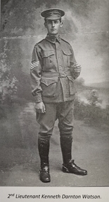
Photograph - Kenneth Darnton Watson - Community Leader
Kenneth Darnton Watson was born at Bendigo on 24 May 1893 to George Darnton Watson and Adelaide Nora Holmes. He was educated at Melbourne Church of England Grammar School, being selected as School Captain in 1913 and a member of the Head of the River rowing team. After finishing school, he worked as a jackaroo on Wanganella Station and later at Mt. Widderin, Skipton, Victoria. When WW1 was declared, Kenneth enlisted and after initial training at Maribyrnong, Victoria he left Australia as 2nd Lieutenant with 7th Australian Field Artillery Brigade, to disembark at Plymouth on July 10, 1916. He took part in the Battles of Messines, Menin Road, Polygon Wood and Passchendaele Ridge in 1917. For his efforts in Passchendaele Ridge on 17th December he was awarded the Military Cross "for conspicuous gallantry and devotion to duty." In 1918 he took part in the Battles of Villers-Bretonneux, Hamel and Amiens. He returned to Australia in November 1919 and was discharged on 20th January 1920. In 1922, Kenneth Darnton Watson came to Wodonga where he purchased de Kerilleau, consisting of 2,500 acres, from Mr George Gordon. The two storey brick homestead had been built by William Huon in 1870. On 30th May 1924, he married Phyllis Emily Lenore Austin and they had four children, Ian Darnton 1925, Robert Darnton 1926 Rosemary McPherson 1929 and Faith Holmes 1931. On the land he worked hard, building fences, cattle, sheep and horse yards, and farmed Corriedale sheep, Shorthorn cattle and horses. Mr Watson was an innovative farmer, introducing modern methods of top dressing at de Kerilleau by means of an aircraft. He was also a dedicated community man. He was a member of both Albury and Wodonga Show Committees, Murray Valley Development League, No.1 Region, Graziers' Association of Southern Riverina, Albury Legacy Club, Wodonga RSL, and Wodonga Turf Club including terms as President on several of these organisations. Kenneth was also a Warden of St. Luke's Church of England, Wodonga. Kenneth served as Wodonga Shire President from 1929 to 1931, and was again elected to Council from 1943 to 1945. A most respected and valued member of the local community, Kenneth Darnton Watson died on the 4th of October 1951, aged 58. Lenore Watson lived at de Kerilleau until her death on 15th June 1984. Both are buried in Wodonga.These images are significant because they record the service of a prominent member of the Wodonga community.A collection of black of white images of Kenneth Darnton Watson of Wodonga.kenneth darnton watson, watson family wodonga, wodonga community members -
 Wodonga & District Historical Society Inc
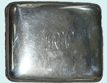
Functional object - Cigarette Case - K. D. Watson, Wodonga
This cigarette case was owned by Kenneth Darnton Watson and carried into battle during World War I. Kenneth Darnton Watson was born at Bendigo on 24 May 1893 to George Darnton Watson and Adelaide Nora Holmes. He was educated at Melbourne Church of England Grammar School, being selected as School Captain in 1913 and a member of the Head of the River rowing team. After finishing school, he worked as a jackaroo on Wanganella Station and later at Mt. Widderin, Skipton, Victoria. When WWI was declared, Kenneth enlisted and after initial training at Maribyrnong, Victoria he left Australia as 2nd Lieutenant with 7th Australian Field Artillery Brigade, to disembark at Plymouth on July 10, 1916. He took part in the Battles of Messines, Menin Road, Polygon Wood and Passchendaele Ridge in 1917. For his efforts in Passchendaele Ridge on 17th December he was awarded the Military Cross "for conspicuous gallantry and devotion to duty." In 1918 he took part in the Battles of Villers-Bretonneux, Hamel and Amiens. He returned to Australia in November 1919 and was discharged on 20th January 1920. In 1922, Kenneth Darnton Watson came to Wodonga where he purchased de Kerilleau, consisting of 2,500 acres, from Mr George Gordon. The two storey brick homestead had been built by William Huon in 1870. On 30th May 1924, he married Phyllis Emily Lenore Austin and they had four children, Ian Darnton 1925, Robert Darnton 1926 Rosemary McPherson 1929 and Faith Holmes 1931. On the land he worked hard, building fences, cattle, sheep and horse yards, and farmed Corriedale sheep, Shorthorn cattle and horses. Mr Watson was an innovative farmer, introducing modern methods of top dressing at de Kerilleau by means of an aircraft. He was also a dedicated community man. He was a member of both Albury and Wodonga Show Committees, Murray Valley Development League, No.1 Region, Graziers' Association of Southern Riverina, Albury Legacy Club, Wodonga RSL, and Wodonga Turf Club including terms as President on several of these organisations. Kenneth was also a Warden of St. Luke's Church of England, Wodonga. Kenneth served as Wodonga Shire President from 1929 to 1931, and was again elected to Council from 1943 to 1945. A most respected and valued member of the local community, Kenneth Darnton Watson died on the 4th of October 1951, aged 58. Lenore Watson lived at de Kerilleau until her death on 15th June 1984. Both are buried in Wodonga.This item is significant because it was owned by a decorated Australian serviceman and prominent member of the Wodonga community.A silver cigarette case owned by Kenneth Darnton Watson of Wodonga. The inside contains straps to hold the cigarettes in place. Both the front and back have been engraved.On front: KDW On back: 1919kenneth darnton watson, watson family wodonga, wodonga community members -
 Wodonga & District Historical Society Inc
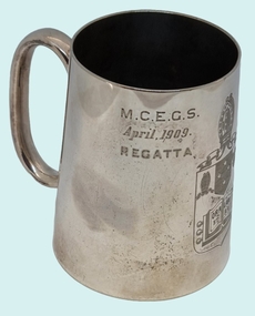
Functional object - Silver Mug - K. D. Watson, Wodonga
This cup was awarded to Kenneth Darnton Watson when he was a boarder and competitive rower whilst completing his secondary education. Kenneth Darnton Watson was born at Bendigo on 24 May 1893 to George Darnton Watson and Adelaide Nora Holmes. He was educated at Melbourne Church of England Grammar School, being selected as School Captain in 1913 and a member of the Head of the River rowing team. After finishing school, he worked as a jackaroo on Wanganella Station and later at Mt. Widderin, Skipton, Victoria. When WW1 was declared, Kenneth enlisted and after initial training at Maribyrnong, Victoria he left Australia as 2nd Lieutenant with 7th Australian Field Artillery Brigade, to disembark at Plymouth on July 10, 1916. He took part in the Battles of Messines, Menin Road, Polygon Wood and Passchendaele Ridge in 1917. For his efforts in Passchendaele Ridge on 17th December he was awarded the Military Cross "for conspicuous gallantry and devotion to duty." In 1918 he took part in the Battles of Villers-Bretonneux, Hamel and Amiens. He returned to Australia in November 1919 and was discharged on 20th January 1920. In 1922, Kenneth Darnton Watson came to Wodonga where he purchased de Kerilleau Homestead, consisting of 2,500 acres, from Mr George Gordon. The two storey brick homestead had been built by William Huon in 1870. On 30th May 1924, he married Phyllis Emily Lenore Austin and they had four children, Ian Darnton 1925, Robert Darnton 1926 Rosemary McPherson 1929 and Faith Holmes 1931. On the land Kenneth worked hard, building fences, cattle, sheep and horse yards, and farmed Corriedale sheep, Shorthorn cattle and horses. he was an innovative farmer, introducing modern methods of top dressing at de Kerilleau by means of an aircraft. He was also a dedicated community man. He was a member of both Albury and Wodonga Show Committees, Murray Valley Development League, No.1 Region, Graziers' Association of Southern Riverina, Albury Legacy Club, Wodonga RSL, and Wodonga Turf Club including terms as President on several of these organisations. Kenneth was also a Warden of St. Luke's Church of England, Wodonga. Kenneth served as Wodonga Shire President from 1929 to 1931, and was again elected to Council from 1943 to 1945. A most respected and valued member of the local community, Kenneth Darnton Watson died on the 4th of October 1951, aged 58. Lenore Watson lived at de Kerilleau until her death on 15th June 1984. Both are buried in Wodonga.These images are significant because they record the service of a prominent member of the Wodonga community.A silver mug awarded to K D Watson as a rowing trophy in April 1909. It features the shield of Melbourne Church of England Grammar School (M.C.E.G.S.), as well as his name and the event for which it was awarded.View 1: M.C.E.G.S. April 1909 Regatta View 2: Crest of MECEGS featuring motto "Ora et Labora" View 3: BOARDERS FOUR K. D. WATSON 3kenneth darnton watson, watson family wodonga, wodonga community members -
 Greensborough Historical Society
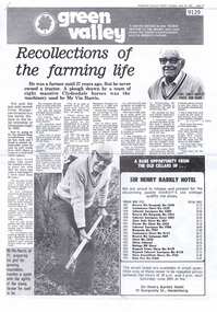
Article - Newspaper Clipping, Diamond Valley News, Recollections of the farming life, 16/06/1981
"Green Valley" series articles about people and artists in Greensborough and surrounds. Front page article about Vin Harris, a Greensborough farmer. Page 2 article about the Harrison family of Lower Plenty and page 3 covers local artists Alan Sartori, George De Nemes and Wayne Viney.Three pages of text and black and white imagesgreensborough, artists - greensborough, vin harris, farming