Showing 360 items matching "glenferrie street"
-
 Vision Australia
Photograph - Image, Interior of the Vision Australia office at 1300 Howitt Street, Ballarat, January 2008
Interior of the Vision Australia office at 1300 Howitt Street, Ballarat, taken by Michelle Prentice during a visit.15 digital photographs of Vision Australia's Ballarat officevision australia, ballarat -
 Vision Australia
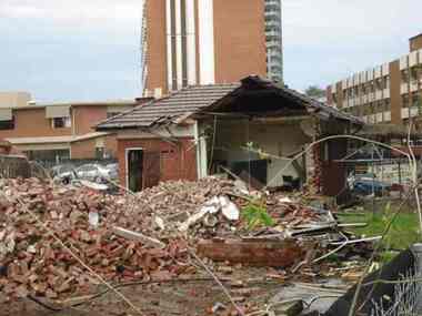
Photograph - Image, Demolition of Raleigh Street premises, 200
On September 23, 1925 the State Goverment gazetted a transfer of land in Raleigh Street, Prahran to RVIB. This was used to establish a hostel for women apprentices and workers, and building commenced in 1926 and was completed in 1927, at a cost of 3500 pounds. Demand for accommodation was strong and in 1929 a hostel for men was completed. The building were used as hostels for many years, but as demand decreased, the Institution found other ways to utilise the buildings. In 1972, a plant nursery was established on the site and other departments temporarily used the site. In 1994 the Employment Services team moved out of the building and the site was sold to developers.17 col. images of the partially demolished house at Raleigh Street, Prahranroyal victorian institute for the blind, raleigh street hostel -
 Vision Australia
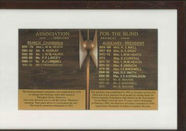
Photograph - Image, Association for the Blind (Geelong branch) Branch Chairman [and] Auxiliary President
The Geelong branch committee was established in 1976 to manage the Geelong Centre then based in Pakington Street, Newtown. One early decision was to call the Centre "Illawarra", meaning 'high place above or overlooking the sea'. The branch committee disbanded in 1993. The auxiliary was established in 1963 to increase services for blind and vision impaired local people by raising funds for Vision Australia Foundation, then known as the Association for the Blind. Over the next 39 years, until is disbanded in February 2002, the Illawarra Auxiliary (renamed in 1976) raised many thousands of dollars to achieve this aim. Branch Chairman: 1976-79 Mrs L.W.M. Heath, 1980-82 Mr R. Averay, 1982-85 Mr L.W.M. Heath, 1985-88 Mr P.P. Larcey, 1988-91 Dr. B.J. Landsell, 1991-93 Mr F. Francesevic Auxiliary President: 1964-66 Mrs K.S. Nall, 1967-69 Mrs G.S. Gray, 1970-72 Mrs L.M.W. Heath, 1973 Mrs E. Currell, 1974-75 Mrs L.W.M. Heath, 1975-78 Mrs E. Snibson, 1979-84 Mrs I.E. Backwell, 1984-86 Mrs D.P. Smith, 1986-89 Mrs E.E.A. Donaldson, 1989-93 Mrs B. McKane, 1993-99 Mrs J. Backwell, 1999- Mrs B. McKane This photograph was taken of the honour board that previously hung in the Geelong Centre.Image of honour board with names of the people who were Geelong Branch chairmen or Auxiliary Presidents association for the blind, illawarra (geelong) -
 Vision Australia
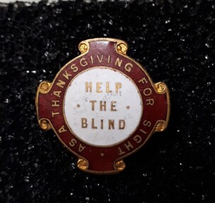
Badge - Object, Help the Blind badge, 1940-1980
To raise funds for the Royal Victorian Institute for the Blind, these badges were sold by street sellers in Melbourne. "Help the Blind" - A red, white and gold badge, circular, with four scroll shapes on the edges. The centre is white, with 'Help the Blind' in gold; the outer area is red with gold edging and words, 'as a thanksgiving for sight'. Some badges have paper numbers on the reverse. Metal pin with red and white enamel, and gold edgingHelp the Blindroyal victorian institute for the blind, badges -
 Vision Australia
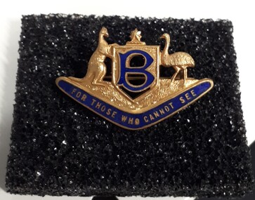
Badge - Object, For Those Who Cannot See badge, 1940-1980
To raise funds for the Royal Victorian Institute for the Blind, these badges were sold by street sellers in Melbourne. A gold colour Australian coat of arms (Kangaroo and emu beside a shield with a star at the top), sits above a blue enamelled boomerang. In the shield is the letter 'B' in blue enamel. 'For those who cannot see' is written in gold lettering across the boomerang. Metal pin with blue enamel letteringFor those who cannot see royal victorian institute for the blind, badges -
 Vision Australia
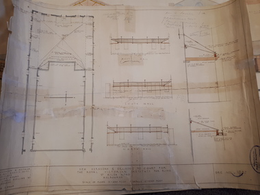
Plan - Image, New verandah & draining to court for the Royal Victorian Institute for Blind, April 1924
In 1924 plans were submitted to the RVIB board for the addition of a new veranda and associated drainage pipes located in the courtyard behind Ormond Hall. Hand written notes on the plan indicate that the tender for materials from Pollards was 330 pounds, asphalt 35 pounds totally a cost of 365 pounds. And that additional costs of 120 pounds, comprising of 20 for G Lavatory (?) and J Famdy (?) 100 pounds.1 architectural plans for proposed verandah and drainageStephenson & Meldrum, Architects Collins Court 374 Little Collins Street Melbourne Phone: 6990royal victorian institute for the blind, plans -
 Vision Australia
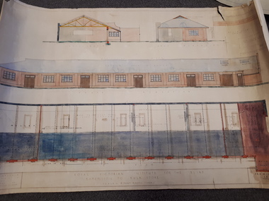
Plan - Image, Royal Victorian Institute for the Blind Extension to Bulk Store, 27/8/1925 (according to Mosiac entry)
In this undated drawing, believed to have been done in 1925, an existing bluestone store was extended out into the courtyard area. The extensions were on the south and west elevations, and the drawing includes a floor plan of these areas. Noted on the plan is the removal of fireplaces that existed in this building, the location abutting the Alfred Hospital reserve and location of the motor room.1 architectural plan of extension to bulk storeStephenson & Meldrum, Architects 374 Little Collins Street Melbourne Phone: 6990 On the back: Widening of old bluestone store plans & specroyal victorian institute for the blind, plans -
 Vision Australia
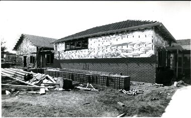
Image, 1983
An image of the extension work done at Kelaston in 1983 for the development of a low vision clinic, and the temporary premises in Mair Street that was utilised whilst the Howitt Street building was unavailable.2 x B/W photographsassociation for the blind, kelaston home (ballarat) -
 Vision Australia
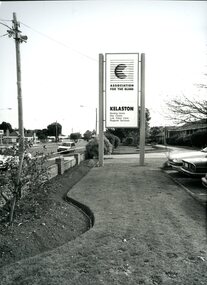
Photograph - Image, AFB Kelaston home photographs taken by Ballarat Courier
Local newspaper photographs taken at the Association for the Blind's Kelaston home in Ballarat. 044 - View of the Kelaston sign and grounds in Howitt Street. 045 - Mr Roy King presented with a plaque in honour of his service. 046 - L to R: Lynne Klien, two residents, Mona Dynon, Laurie Hay (day centre coordinator) upon the occasion of Laurie's retirement. 052 - L to R: Ruby Blake, Don Dunstan (manager of Kelaston) and another nursing home resident. 054 - L to R: unknown, Dianne Kerr, Bob de Little and a visitor look on in the craft room.5 x B/W photographs of Kelaston nursing homeassociation for the blind, kelaston home (ballarat), dianne kerr -
 Vision Australia
Object, Patience board, 19
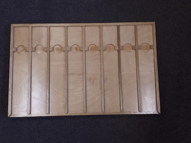
This wooden board has two differently designed sides: one with four strips running the length of the board and the other with seven strips of wood running across the width of the board. These strips and various ridges around the edge and in the 'lanes' assist players as they play card games. The attached booklets describe the sides as Squares (4 strips) or Streets (7 strips), which could be used to play a variety of card games described. On the Squares side: Carpet, Count Nogo, Frames and Poker Patience and on the Streets side: Triangles and Henley could be played in addition to the traditional game of Patience. The board was designed to be used with a distinct sized card (RNIB no. 9087) that could fit between the strips. Wooden board with card dividers with accompanying printed and braille booklet. recreation equipment, games -
 Vision Australia
Text, Association for the Advancement of the Blind Home Committee April 1930 - December 1936, 1930-1936
Minutes of the monthly meetings of the AAB Home Committee held at 7 Mair Street, Brighton to discuss items related to the running of the Brighton home for the Blind (later named 'Elanora'). A brief index of names preceeds the minutes. Agenda topics included Accounts, Matron's Report, Applications for Admission and Official Visitors, infirmary rules (p.13), potential removal of residents due to improper conduct (p.31, 46 & 112) and applications for position of Matron (p.147). 1 paper registerassociation for the advancement of the blind, elanora home (brighton) -
Vision Australia
Text, Association for the Advancement of the Blind Home Committee January 1937 - November 1941, 1937-1941
Minutes of the monthly meetings of the AAB Home Committee held at 7 Mair Street, Brighton to discuss items related to the running of the Brighton home for the Blind (later named 'Elanora'). A brief index of names preceeds the minutes. Agenda topics included Accounts, Matron's Report, Applications for Admission and Official Visitors, rules for admission and guidance (p.i), dissatisfaction between staff (p.19), installing ear phones in the infirmary (p.103) and the potential purchase of land at the rear of the home (p.168). Correspondence and an inmates register have been listed for some of the period. 1 paper registerassociation for the advancement of the blind, elanora home (brighton) -
Vision Australia
Text, Association for the Advancement of the Blind Home Committee November 1941 - May 1950, 1941-1950
Minutes of the monthly meetings of the AAB Home Committee held at 7 Mair Street, Brighton to discuss items related to the running of the Brighton home for the Blind (later named 'Elanora'). A brief index of names preceeds the minutes. Agenda topics included Accounts, Matron's Report, Applications for Admission and Official Visitors, appointment of a special nurse (p.39), an Adventist service conducted in the home being too large and needed to reduce number (p.92), and that bread for tea should be buttered late in the afternoon and not be in a melted condition (p.154). 1 paper registerassociation for the advancement of the blind, elanora home (brighton) -
Vision Australia
Text, Association for the Advancement of the Blind Hostel Committee 1 July 1935 to 29 May 1939, 1935-1939
Minutes of the monthly meetings of the AAB Hostel Committee to discuss items related to the running of the Mens Hostel at 11 Lara Street, South Yarra and the Women's Hostel at 54 The Avenue, Windsor. Agenda topics included Receipts and Accounts, Admissions, reports from both hostels and Official Visitors, removal of keys from inmates doors (p.28), an approach to 3XY to obtain additional readers for the Men's Hostel (p.162) and copies of correspondence to housekeepers of both hostels. 1 paper registerassociation for the advancement of the blind -
Vision Australia
Text, Association for the Advancement of the Blind Hostel Committee 31 July 1939 to 4 July 1947, 1939-1947
Minutes of the monthly meetings of the AAB Hostel Committee to discuss items related to the running of the Mens Hostel at 11 Lara Street, South Yarra and the Women's Hostel at 54 The Avenue, Windsor. Agenda topics included Receipts and Accounts, Admissions, reports from both hostels and Official Visitors, asking residents if they have relatives to go to in case of air raids or if they wish the Association to make arrangements for their evacuation (p.89) and copies of correspondence to housekeepers of both hostels. 1 paper registerassociation for the advancement of the blind -
Vision Australia
Text, Association for the Advancement of the Blind Hostel Committee 3 September 1947 to 7 May 1958, 1947-1958
Minutes of the monthly meetings of the AAB Hostel Committee to discuss items related to the running of the Mens Hostel at 11 Lara Street, South Yarra and the Women's Hostel at 54 The Avenue, Windsor. Agenda topics included Receipts and Accounts, Admissions, reports from both hostels and Official Visitors, rules of the hostel including no washing on Sundays (p.75), the closure of the Mens Hostel (p.78), regret that the sale of the Women's Hostel was not advised prior, and that when a new hostel is established, it be named in honour of Mrs L. Hutchinson (p.173). 1 paper registerassociation for the advancement of the blind -
Vision Australia
Text, Association for the Advancement of the Blind Finance and Executive minutes from 1/1/1936 to 6/12/1939, 1936-1939
At the front of the minutes is an index of names for some of the people referred to in the minutes of the Finance/Executive Commitees, with relevant page numbers. Held at the office of the Association for the Advancement of the Blind, these minutes contain information on bank balances, correspondence received and replied to, receipts expenditure, accounts and other business discussed. This included concerts, applications for pensions and a reference to the movement to a new premises at 118 Queen Street (p30).1 paper registerassociation for the advancement of the blind -
Vision Australia
Text, Association for the Blind General Committee minutes from 31/5/1976 to 29/10/1979, 1976-1979
Held at the office of the Association for the Blind, these minutes contain information on attendees, meeting chair, apologies, confirmation of minutes, reports, matters arising from reports, recommendations, general business and the date of the next meeting. This included a renovation to provide offices at 21 New Street so that more beds could be added to Elanora, establishment of the John Wilson Award, and acceptance of the recommendation that the Association be a resource centre for small self-help groups. 1 paper registerassociation for the blind -
 Vision Australia
Pamphlet - Text, Do you know what this is?
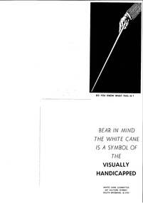
A leaflet produced to raise awareness of white canes. On the front a man's hand holds a white cane. Inside the leaflet reads "Bear in mind the white cane is a symbol of the visually handicapped" and was produced by the White Cane Committee, 247 Vulture Street, South Brisbane, Q, 4101.1 page with illustration of white caneIllustration of a hand holding a white cane on the front pagewhite cane day, advertising -
 Vision Australia
Badge - Object, Remember the Blind badge, 1940-1980
To raise funds for the Royal Victorian Institute for the Blind, these badges were sold by street sellers in Melbourne. "Remember the Blind" - Blue and white oval badges with the words, 'Remember the Blind' around the edge. The outer oval is narrow, white with gold edges and words. A dark blue oval is in the centre, suspended over the empty space by four curved pieces of metal, with gold edging. Some badges have paper numbers on the reverse. Metal pin with enamel with writingRemember the Blind royal victorian institute for the blind, badges -
 Vision Australia
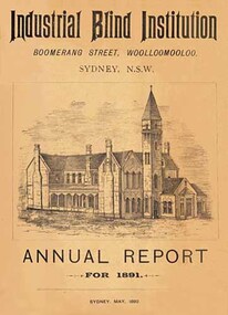
Text, Sydney Industrial Blind Institution annual reports 1879-1898, 1879-1898
In 1875 John William Wood left a legacy of 5000 pounds for a building to be erected for the benefit of people who were blind. A site near William Street was agreed upon, and building commenced of a two storey sandstone in Boomerang Street. Some months after its completion, a public meeting was held to inaugurate the Sydney Industrial Blind Institution, outline its rules and regulations and elect a board of management. To publicise it's work and gain donor support, the SIBI produced an annual report outlining the finances, facilities and programs offered.1 volume, illustrationssydney industrial blind institution -
 Vision Australia
Image, 15/10/1979
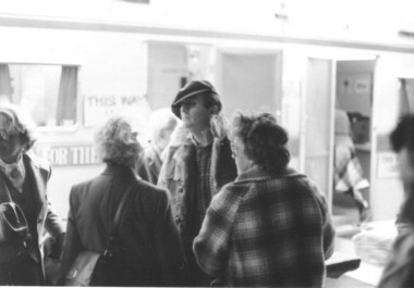
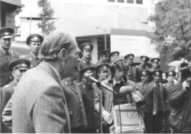
October 15, 1979 was the very first publicly proclaimed White Cane Day in Victoria. Announced by Premier Hamer, onlookers were invited to learn more about the various societies in Victoria that assisted the blind and vision impaired. Barry Humphries was the guest of honour, and spoke with a small group before venturing out with his own white cane to test out Melbourne’s wet streets. Caravans were set up along Swanston Street to distribute information. The RAAF band played and a square dance exhibition was held by vision impaired dancers in Bourke Street. 13 B/W photographs w/ 20 negatives and 23 col. negativesOn the back of BRIP381.11 is a partially erased pencil description 'Kathy Zwald' and 'Doris Nothling".white cane day, barry humphries, doris nothling, kathy zwald -
 Vision Australia
Image, 15/10/1979
October 15, 1979 was the very first publicly proclaimed White Cane Day in Victoria. Announced by Premier Hamer, onlookers were invited to learn more about the various societies in Victoria that assisted the blind and vision impaired. Barry Humphries was the guest of honour, and spoke with a small group before venturing out with his own white cane to test out Melbourne’s wet streets. Caravans were set up along Swanston Street to distribute information. The RAAF Central band played and a square dance exhibition by The Lightfooters (a group ofvision impaired dancers) in Bourke Street. 12 B/W photographswhite cane day, raaf central band -
 Vision Australia
Photograph - Image, Man using white cane and sonic guide
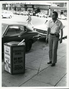
A bearded man uses a white cane and sonic guide to help him navigate around the streets of Strathfield. The sonic guide consists of a pair of heavy black spectacles with three sensors built into the bridge of the glasses. The glasses are attached by a cable to a control box which is designed to be clipped onto the wearer's belt or clothing. The control box has two switches and a volume setting, and assists the user in determining objects in their path and their distance to them.2 B/W photographs of man using sonic guide and white cane"5156-220" and '5156-224" on back of photographsroyal blind society of nsw, white cane, orientation and mobility -
 Vision Australia
Photograph - Image, Michael Yanchenock walking around Sydney, 1969
Michael Yanchenock uses his white cane to navigate around the side of a building in Sydney both alone and with mobility instructor Margit Rihr. These pictures were taken near the William Street/Boomerang Street building of RBS.2 x Sepia toned photograph of orientation and mobility training1-1769 Michael Mobility training Oct 1969 Photographic Illustrators, Double Bay 2-1769 Photographic Illustrators, Double Bay - 36-1764. Margit Rihr & Michael Yanchenock - mobility training October 1969, Mobility - historicalroyal blind society of nsw, white cane day, orientation and mobility, michael yanchenock, margaret rihr -
 Vision Australia
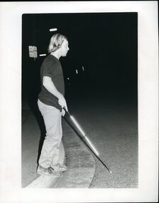
Photograph - Image, Man crossing street using white cane at night
A man uses a white cane crossing a street at night in Newcastle. His cane reflects the photographer's flash and is illuminated against the dark night.Black and white photograph of a man using a white cane at nightOrientation and mobility at night - Newcastle Please return to RBSwhite cane day, royal blind society of new south wales -
 Vision Australia
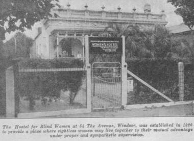
Photograph - Image, Women's Hostel (Egremont) in Windsor newspaper cutting
The AFB were aware that accommodation options for blind people were limited and sought to open a hostel to assist with this.The first hostel opened in Lara Street, South Yarra but could not meet demand. In 1926, a suitable property 'Egremont' at 54 The Avenue, Windsor, came on the market. The price was £2650. Lack of funds to purchase seemed an insurmountable barrier. With assistance from the Trustees of the Edward Wilson Estate and the Felton Bequest a deposit of £650 was raised. In a huge step of faith the Committee took out a mortgage of £2000. The interest on the mortgage and its repayments weighed heavily on the Committee. The Avenue, as 'Egremont' was commonly termed, was also a seven roomed house. Mr Paterson and the Architect, Mr Parkes of Oakley and Parkes, immediately began planning an extension, fourteen single bedrooms were added. They were filled from the Waiting List. A Windsor Auxiliary was formed and worked to reduce the mortgage of £2000. An active programme of dances, card evenings, theatre nights and the like took place under the leadership of Mrs. Robertson. The Auxiliary also took an interest in the boarders, arranging entertainment and social activity. £1500. was still owed in 1930. Living side by side is no easy task for a group of people, and the Hostel meeting minute books are filled with stories of disputes over wireless sets, telephones, hot water bottles and wardrobes. In 1958, with rising costs and the growth of aged care centres, the Hostel was closed and the house sold to a succession of private buyers. In 2016 it still stands and has been refurbished as a guest house.B/W copy of newspaper photographThe hostel for blind women at 54 The Avenue, Windsor was established in 1926 to provide a place where sightless women may live together to their mutual advantage under proper and sympathetic supervision. The Windsor Hostel was sold in 1958. This building still stands today and has been refurbished.egremont, blind womens hostel, tilly aston -
 Vision Australia
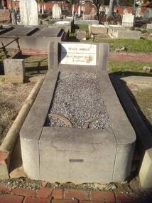
Photograph - Image, Gael Vincent, Grave of Matilda Ann Aston in St Kilda cemetery, 2016
Tilly Aston moved to 42 Raleigh Street in 1913, after her mother had died and her brother married. She died there of cancer on 1 November 1947 and was buried in St Kilda cemetery; her estate was valued for probate at £1149. Her headstone is inscribed: headstone ‘Tilly Aston, Blind Poetess and Philanthropist, Died 1st Nov 1947, Aged 74, Resurgam.’2 x col. photographs of grave and headstonetilly aston, association for the blind -
 Vision Australia
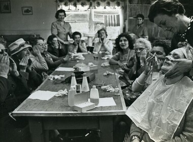
Photograph - Image, Pampering session at RBS
A group of ladies sit around a table, rubbing make up products into their face. One lady, in the foreground, is receiving a facial massage.1 B/W photograph of woman sitting and rubbing lotion on their faces12 A recreation - William Streetroyal blind society of new south wales, recreation -
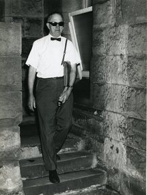 Vision Australia
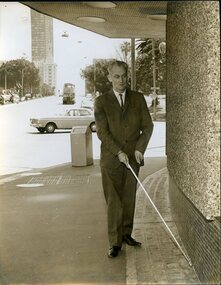
Photograph - Image, Man using an ultrasonic torch at William Street, 1968
An ultrasonic torch sends out a high frequency beam that bounces off items in it's path and sends back signals to an ear piece worn by the user. A change in sound indicates the nearness of an object, and it was (at the time) thought to be a possible replacement for white canes in the future. In this image, a man descends steps at the William Street building of RBS, using the torch to guide him.B/W photograph of man using torch6/68049 Ultrasonic torch being used at the Royal Blind Society.royal blind society of new south wales, orientation and mobility