Showing 108 items matching "greensborough hotel"
-
 Greensborough Historical Society
Postcards, Yarra Plenty Regional Library, Eltham District Historical Society postcards, 1900s
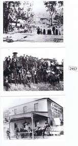
1. Watson's Hotel, cnr. Pitt Street and Main Road Eltham c. 1902. 2. Main Road Hurstbridge. 3. Railway workers celebrate the first steam train to Hurstbridge 1912Three black & white postcardswatson's hotel, eltham, hurstbridge, hurstbridge train line, eltham district historical society -
 Greensborough Historical Society
Compact disc, Jasmin Burge, Photographs by Jasmin Burge, 2011-2013
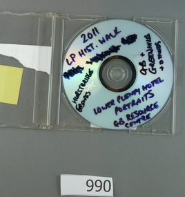
... . Mainly focused on Greensborough area, there are also photographs...Greensborough Historical Society 34A Glenauburn Road Lower ...Contains a collection of photographs by Jasmin Burge. Mainly focused on Greensborough area, there are also photographs of Loyola College, Lower Plenty Hotel, Hurstbridge and some Greensborough Historical Society activities.A collection of 21st century photographs of the Greensborough area. 1 compact disk in plastic case. Contains photographs.In black pen on cd: "LP Hist walk, Hurstbridge graves, GB and Greenhills, Lower Plenty hotel portraits, GB Resource Centre."greensborough, greensborough cemetery, loyola college, greensborough historical society, jasmin burge -
 Greensborough Historical Society
Article, The Willis Diary by Anne Paul. Based on A Pioneer Squatter's Life, 09/04/1837o
The Willis Diary by GHS member Anne Paul is based on A Pioneer Squatter's Life (Item158). The Willis family were early settlers at Lower Plenty, just near where the hotel and old bridge are today. Anne has reviewed and analysed this chapter from Historical Records of Victoria, Vol. 6. The Crown, the land, and the squatter, 1835-1840. She includes further information on the Willis family and photographs of the archaeological dig at the Bridge Inn Hotel Mernda in 2017.Diary of James L Willis from 1837, portraying hardships suffered in the young colony of Victoria.15 page, text and colour illustrations. Digital copy.willis family, plenty river, lower plenty, james willis, bridge inn hotel mernda -
 Greensborough Historical Society
Photograph - Digital image, Charles Marshall et al, Hotel with woman on verandah, 1920s
This photograph shows a country hotel with a woman standing on the verandah, possibly Charles' wife Doris.Digital copy of black and white photograph. No caption on this photocharles marshall, world war 1 -
Greensborough Historical Society
Article, A Squatter's life on the Plenty River at 'Wanstead' by Anne Paul, 09/04/1837o
The Willis Diary by GHS member Anne Paul is based on A Pioneer Squatter's Life (Item158). The Willis family were early settlers at Lower Plenty, just near where the hotel and old bridge are today. Anne has reviewed and analysed this chapter from Historical Records of Victoria, Vol. 6. The Crown, the land, and the squatter, 1835-1840. She includes further information on the Willis family and photographs of the archaeological dig at the Bridge Inn Hotel Mernda in 2017.Diary of James L Willis from 1837, portraying hardships suffered in the young colony of Victoria.10 pages, text and colour illustrations. Abridged hard copy of item 4491.willis family, plenty river, lower plenty, james willis, bridge inn hotel mernda -
 Greensborough Historical Society
Newspaper clipping, D. Medhurst, Early closing of hotels, by D. Medhurst, 08/07/1916
Written by Greensborough local David Medhurst, this article bemoans the effect of drinking on the population.1p. Reprint of Letter to the Editor, Heidelberg News , by D. Medhurst, Greensborough residentdavid medhurst, hotels -
 Greensborough Historical Society
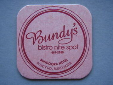
Coaster - Digital Image, Bundoora Hotel, Bundoora Hotel coasters, 1990, 1990s
Digital image of drink coaster from Bundoora Hotel (also known as Bundy's Bistro), 1990s.Part of a collection of miscellaneous historical images with a connection to the local area.Digital image of 4 coasters. 3 with white card with red text and logo; one green card with red logo."Bundy's Bistro" or "Bundoora Hotel"bundoora hotel, bundys bistro -
 Greensborough Historical Society
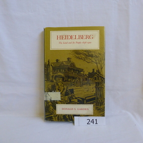
Book, Melbourne University Press, Heidelberg: the land and its people 1838-1900; by Donald P. Garden, 1838-1900
This book covers the early history of Heidelberg, Victoria from its beginnings in 1838 to 1900.There is some reference to the 'annexation' of Greensborough in 1875 and the route of the Heidelberg-Eltham railway line, 1893.Hard cover book. 218 p., ill., maps. Slip cover has a drawing based on an early photograph of the Old England Hotel.Property stamps from Nunawading Public Library (cancelled from their collection)heidelberg, greensborough, donald garden -
 Greensborough Historical Society
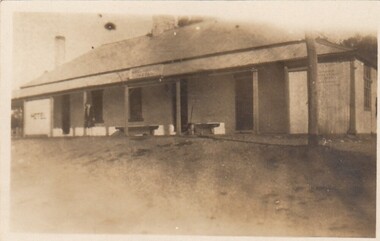
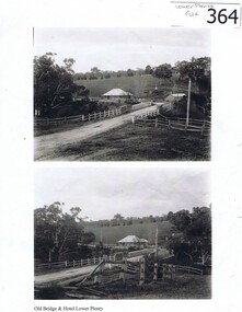
Photograph (copy), Old Bridge and Hotel Lower Plenty, 1925c
2 historical views of the Lower Plenty bridge and hotel. Original photographs are in the Victorian State Library collection.Both the bridge and hotel remain but are in a very different landscape. This shows the area about 110 years ago.A4 photocopy of 2 black and white photographslower plenty, lower plenty hotel, plenty river, lower plenty river bridge. -
 Eltham District Historical Society Inc
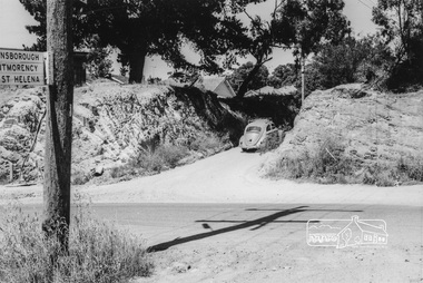
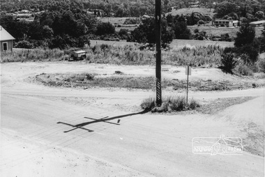
Photograph, Intersection of Main Road and Bridge Street, Eltham, February 1968, Feb 1968
Shows a VW Beetle (GVM-459) heading east up the hill on Bridge Street continuance which at the time was slightly mis-aligned. Also street direction signs to Greensborough, Montmorency and St Helena.In February 1968 an unknown person took a series of photos from the Eltham Hotel at Pitt Street heading north along Main Road through the shopping centre to just north of Elsa Court covering the length of the section of Main Road which was duplicated shortly thereafter. Shows the condition and environment of the streesscape of Main Road, Eltham immediately prior to the duplication between Pitt Street and Elsa Court through the shopping centre. Also shows a number of shops and businesses that operated at that time.Black and white photographduplication, eltham, main road, bridge street -
 Eltham District Historical Society Inc
Photograph, Intersection of Main Road and Bridge Street, Eltham, February 1968, Feb 1968
Shows street signs on pole for Greensborough, Montmorency and St HelenaIn February 1968 an unknown person took a series of photos from the Eltham Hotel at Pitt Street heading north along Main Road through the shopping centre to just north of Elsa Court covering the length of the section of Main Road which was duplicated shortly thereafter. Shows the condition and environment of the streesscape of Main Road, Eltham immediately prior to the duplication between Pitt Street and Elsa Court through the shopping centre. Also shows a number of shops and businesses that operated at that time.Black and white photographduplication, eltham, main road, bridge street -
 Eltham District Historical Society Inc
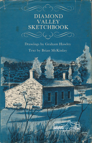
Book, Diamond Valley sketchbook / text by Brian McKinlay ; drawings by Graham Hawley, 1973
Contents include short articles and illustrations of historic properties within the municipalities of Banyule, Nillumbik and Whittlesea. Including The Griffin House, Rosehill, Lower Plenty, The Austin Hospital, Heidelberg, St John's Church, Heidelberg, Banyule, Heidelberg, Trestle Bridge, Eltham, Diamond Valley railway, The Shillinglaw Cottage, Eltham, Montsalvat, Old England Hotel, Heidelberg, Eltham Primary School, Mud brick homes, Eltham, Sweeney's Cottage, Eltham, Pound Pend Tunnel, The Gold Memorial, Potter's Cottage, Memorial Tower, Charterisville, Weller's Pub, The Barrel, Eltham, Hassall's Gallery, The Old Bridge, Greensborough, Diamond Valley Shire Offices, Greensborough, St Katherine's Chapel, Yan Yean Reservoir, Mernda Hotel, Mernda Mechanics Institute, Old Barn, Mernda, Parade College, La Trobe University.Hardback with jacket ; 63 p. : ill., maps ; 22cm. diamond valley shire, shire of nillumbik, city of whittlesea, city of banyule, shillinglaw cottage, weller's hotel -
 Surrey Hills Historical Society Collection
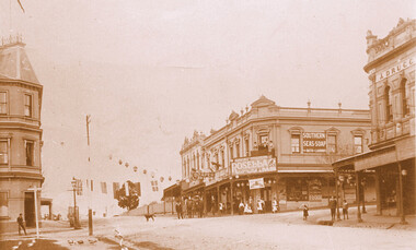
Photograph, Kenneth (Ken) Tudor Hall, Alfred Davies grocery store, corner Canterbury and Union Roads, 1906 or 1909, Original: 1906 or 1909; Copy photo by Ken Hall c1982
Ref: Mr & Mrs J Davies, Greensborough - Alfred Davies took over this store in 1904. He lived with his wife, Lucretia and 5 children above the store. His son Cyril recalled sleeping on the corner balcony on hot nights. Alfred Davies was a strong Temperance man and gave up the store when clients pressured him to collect their beer from the hotel opposite and deliver it with their grocery orders. The pharmacy moved across the road to this corner in 1936 when acquired by Dartnells. The corner shop in Woodheads building was a store and other businesses over the years. The "Druggist" on right, in Hansen's Exchange building, was established in 1889. From 1910 Percy Cathcart conducted the pharmacy there until 1936 when he was joined by Vic Dartnell, his cousin. In 1940, Vic transferred the business to Woodheads corner. His son John followed as a pharmacist until his daughter Amanda became the pharmacist. After the Dartnell family sold the business, the pharmacy continued in a similar manner as a compounding pharmacy and retained 'Dartnell' in its name.This documents the importance given to celebration of the British Empire in the Surrey Hills area in the first half of the 20th century. It also documents the earliest centre of business activity in the area with 2 major sets of dual occupancy residential and retail terraces - the Woodhead buildings and Hansen's Exchange, the later set of terraces having been demolished c1971.Sepia photo of the corner of Canterbury and Union Roads in 1906 or 1909 festooned with flags and lanterns for Empire Day celebrations. On the SE corner is Alfred Davies grocery store with advertising signs for Rosella jams and Southern Seas soap. There are people standing on a balcony above the Rosella advertising sign. Other adults and children stand in the street and there is a cab outside the draper's further east in Canterbury Road. On the opposite corner to Alfred Davies is a druggist and on the north-west corner is McNeil's Family Hotel.mcneil's family hotel, empire day, festivals and celebrations, grocers, pharmacists, alfred davies, businesses, woodhead's buildings, john woodhead, percy cathcart, hansen's exchange, hansen's folly -
 Eltham District Historical Society Inc
Photograph - Digital Photograph, Alan King, Golden King Mine poppet-head, Yarrambat Primary School, 1 February 2008
... Hotel, also called Evelyn Arms and Tunnel Hill Hotel... Hotel, also called Evelyn Arms and Tunnel Hill Hotel ...The Golden King Mine poppet-head stands at the school’s Yan Yean Road exit gate. Published: Nillumbik Now and Then / Marguerite Marshall 2008; photographs Alan King with Marguerite Marshall.; p23 Early Yarambat - Tanck's Corner Its early settlers, who in the 1840s were amongst the first non-Aboriginal people in the area, found life tough as they grazed their sheep and cattle. Yarrambat was then known as Tanck’s Corner or Reynolds Corner, after wood carter, Frederick Tanck, who owned land north of Ironbark Road, at the corner of Yan Yean Road, and Thomas Reynolds, owner of the opposite property. After Reynolds sold his land, the corner became known as Tanck’s Corner. In 1929 the district’s name was changed to Yarrambat, believed to mean ‘high hill’ in the Wurundjeri language. Tanck’s Corner was in the centre of gold-bearing country and the district is honeycombed with old tunnels and shafts. However although gold played a dominant role for decades, there was insufficient to develop a substantial township. Meat and agricultural produce made a greater impact. Until the mid-20th century the only substantial building was the primary school. The first gold rush occurred around 1860, the second after 1900; then during the Depression, the Government paid men to pan for gold. The first rush attracted hundreds of Chinese people to Smugglers Gully, who constructed round diggings to keep away spirits. Alluvial miners lived along the Plenty River in tents or humpies - some fenced with gardens - and some miners distilled their own ‘plonk’. It was a wild time and bushrangers - and later gangster Squizzy Taylor - were said to hide4 in the old Pioneer Tunnel in Dunne’s Gully between Heard Avenue and Pioneer Road. Mines opposite Tanck’s Corner included Beer’s Line, Golden Crown and Golden Stairs. Some of the big mines had batteries and stampers to process quartz. At first there was plenty of alluvial gold, as much as two ounces to the ton. At times gold was exposed after heavy rains so fossickers panned for gold around orchard irrigation trenches. Gold was mined until 1984 when Yarrambat’s last operating goldmine, the Golden King Mine, in North Oatlands Road, closed. The Clayton family operated it full-time, making a comfortable living and in the 1960s it was the only private family gold mine in Victoria.5 Gold was such an important part of Yarrambat’s history that a gold poppet-head is the Yarrambat Primary School’s logo. The Golden King Mine poppet-head stands at the school’s Yan Yean Road exit gate. However this school was built in 1988. The original school No 2054, at the corner of Ironbark and Yan Yean Roads, was opened in 1878 and modified to its present form in the 1920s. In 2000 it was relocated to the Heritage Museum at Yarrambat Park.7 The school, whose first head teacher was Charles Planner, consisted of one room with a three-roomed residence. The school was also the community centre. On Saturday nights it was crammed for dances or euchre parties, community singing or other social events. On Sundays, services for different denominations took turns each week. However the school had its teething problems. Parents accused Charles Planner of neglecting his duties and the school closed several times. When it closed in 1892, only church services continued. Social activities moved elsewhere, such as the tennis club to the Stuchbery tennis court opposite. A sports day and woodchop on Boxing Day around 1900 was held at the Evelyn Hill Hotel, also called Evelyn Arms and Tunnel Hill Hotel, on the Greensborough–Diamond Creek Road. An annual agricultural show in Diamond Creek paraded through the town, and New Year’s Day picnics at the Yan Yean Reservoir included highland dancing and competitions. Also popular were the Indian hawkers who visited every three months, selling trinkets, clothing and other items. One called Jimmy ‘Allem dem Bedi’, gave presents and told stories, played draughts and sold delicious curries he cooked over his camp fire at night.This collection of almost 130 photos about places and people within the Shire of Nillumbik, an urban and rural municipality in Melbourne's north, contributes to an understanding of the history of the Shire. Published in 2008 immediately prior to the Black Saturday bushfires of February 7, 2009, it documents sites that were impacted, and in some cases destroyed by the fires. It includes photographs taken especially for the publication, creating a unique time capsule representing the Shire in the early 21st century. It remains the most recent comprehenesive publication devoted to the Shire's history connecting local residents to the past. nillumbik now and then (marshall-king) collection, golden king mine, tanck's corner, yarrambat primary school -
 Eltham District Historical Society Inc
Photograph - Digital Photograph, Alan King, Maroondah Aqueduct Siphon Bridge over the Plenty River, 26 January 2008
Opened in 1891, the bridge formed part of the Maroondah Aqueduct carrying water from Watts River near Healesville to the reservoir at Preston where it joined Melbourne's metropolitan water system. Covered under Heritage Overlay, Nillumbik Planning Scheme. Published: Nillumbik Now and Then / Marguerite Marshall 2008; photographs Alan King with Marguerite Marshall.; p99 Built to supply thirsty Melbourne in the late 19th century, the siphon bridge spanning the Plenty River off Leischa Court, Greensborough, was part of an engineering masterpiece. Opened in 1891, the bridge formed part of the Maroondah Aqueduct carrying water from the Watts River near Healesville to the reservoir at Preston where it joined the metropolitan distribution system. A major link in Melbourne’s water supply, it also had a huge impact on communities, which mushroomed along its route. Named after the Aboriginal word for the area around the Maroondah Reservoir, the Maroondah Aqueduct was fully operational until the 1970s. Since the 1980s the land along parts of the aqueduct have been used for walking and bicycle riding, shaded in places by Monterey Pine trees planted to stabilise the surrounding ground. From 1857 the Yan Yean Reservoir supplied Melbourne’s water but the growing city needed additional catchments.1 In 1886 work began on a weir on the Watts River to enable the aqueduct to carry most of the river water 41 miles (66km) to Melbourne. The aqueduct, built by the Board of Works, is the oldest remaining aqueduct near Melbourne and was probably the first built with concrete.2 Although the aqueduct is now only used between the Maroondah and Sugarloaf Reservoirs, it can still be traced across the Shire. It extends from the Maroondah Reservoir through Christmas Hills, Kangaroo Ground, Research, Eltham, St Helena and then previously wound west through Greensborough to Reservoir.3 Built by horse and manpower the aqueduct gravity fed 25 million gallons (113.6ML) of water a day to Melbourne along a gradient of one foot to the mile. It included 25 miles (41km) of open concrete and brick channel, six miles (10km) of tunnels, and nine miles (15km) of 14 inverted siphons of riveted wrought-iron across creeks. Bricks for the aqueduct were made from clay found near the sites and remains of several kilns can still be found between Kangaroo Ground and Christmas Hills. Building the aqueduct transformed local communities. An abattoir was established at Christmas Hills. Grog shanties and labourers’ camps sprang up and local courts dealt with cases of ‘petty pilfering and boisterous behaviour’.4 The Kangaroo Ground school population jumped to 91, crammed into a room with one teacher. Miners who built the tunnels camped just north of Churinga in Greensborough – then called Tunnel Hill Camp – and adjacent to the Evelyn Arms Hotel. The miners’ high spirits were sometimes quenched in horse troughs or by a ‘welt under the ear and kick on the behind’ as the local constable calmed them down rather than lock them up.5 But the growing city of Melbourne needed more water, so the O’Shannassy catchment, east of Warburton, was added to the system in 1914. In 1920 work began on the present concrete Maroondah Dam one mile (1.6km) from the weir on the Watts River. The aqueduct capacity was thus doubled to 50 million gallons (227ML) a day.6 Intense land development threatened to pollute the open water supply, so channel sections were replaced with large pipes. In the late 1960s a large water main was built from the tunnel outlet at Research and extended through St Helena and Greensborough, so this section of the aqueduct was taken out of use. Long sections of the unused open channels in Greensborough and Bundoora were destroyed, but the old channel in Research and Eltham North remained largely intact. In the 1970s, the Sugarloaf Reservoir was constructed, inundating 445 hectares of land in Christmas Hills. Sugarloaf was officially opened in 1980 and serves as a water storage and treatment plant supplying Melbourne. In the early 1980s pipes replaced the section from Sugarloaf Reservoir to the tunnel entrance at Kangaroo Ground. The Research-Kangaroo Ground tunnel operates as part of the pipeline system.This collection of almost 130 photos about places and people within the Shire of Nillumbik, an urban and rural municipality in Melbourne's north, contributes to an understanding of the history of the Shire. Published in 2008 immediately prior to the Black Saturday bushfires of February 7, 2009, it documents sites that were impacted, and in some cases destroyed by the fires. It includes photographs taken especially for the publication, creating a unique time capsule representing the Shire in the early 21st century. It remains the most recent comprehenesive publication devoted to the Shire's history connecting local residents to the past. nillumbik now and then (marshall-king) collection, maroondah aqueduct, pipe bridge, siphon bridge -
Eltham District Historical Society Inc
Document - Folder, Shallard family
Jack and Mary Emma Shallard and their three children, Bill, Joyce and Jack, moved to the Eltham area around 1912. Jack married Blanche Everard and lived in Montmorency and was active in community matters. Contents Photocopy page, October 1920, re Eltham, noting Joseph Bromley Shallard as a Councillor for Eltham. Photograph: Eltham Historical Society display at home of Joy and Bruce Ness 1987, Les Robertson, Jack Shallard, Blanche Shallard and Margorie North. Photograph: Eltham Historical Society float, Eltham Festival Parade 1988, Blanche Shallard, Opal Smith and Eileen Gibbon. Manuscript and typed notes, no date: Memories of Eltham and district by Jack Shallard Newspaper article: "Jack Shallard will be sadly missed", Diamond Valley News, 18 June 1991. Obituary of Jack Shallard. Letter Elizabeth Pidgeon to Eltham District Historical Society, 20 March 2001: Seeking information on Shallard family of Eltham, provides information on Roberts and Tinker families. Newspaper death notice for Blanche Shallard, The Age, 12 September 2002. Newspaper funeral notice for Blanche Shallard, The Age, 13 September 2002. Order of Service: Blanche Emily Shallard, St Faith's Anglican Church, Montmorency, 13 September 2002. Eulogies for Blanche Shallard by Jan Mullins, Kerry Knowles, and grandchildren of Blanche Shallard. Letter Sue Law to the Shallard family, 15 September 2002. Acknowledging contribution of Blanche Shallard to EDHS and seeking copies of eulogies. Newspaper article: "Community honours a favourite resident", Diamond Valley Leader, 20 November 2002. Obituary of Blanche Emily Shallard with photograph. Notes, undated, of Sue Law's recollections from Blanche Shallard. Newspaper advertisement: "63 and 65 Rattray Road, Montmorency", Diamond Valley News, no date. For sale 63 and 65 Rattray Road, Montmorency. Newspaper advertisement: "63 and 65 Rattray Road, Montmorency", Diamond Valley Leader, 12 March 2003. Auction 5 April of 63 and 65 Rattray Road, Montmorency.Newspaper clippings, A4 photocopies, etcjoseph shallard, mary emma shallard nee tinker, elizabeth ann tinker nee roberts, susan shallard nee roberts, james roberts, sarah roberts nee pope, joseph bromley shallard, william shallard, joseph tinker, jack vincent shallard, jocelyn shallard, christopher shallard, elsie shallard nee mills, meruka house sherbourne road, mary north, jack shallard, blanche shallard nee everard, bill everard, eltham primary school, melbourne high school, university of melbourne, holy trinity church of england kew, st margaret's church of england eltham, st faith's church of england montmorency, best hooper rintoul and shallard, diamond valley community hospital, blanche emily shallard nee everard, 63-65 rattray road montmorency, jan mullins, kerry knowles, joy neww, bruche ness, les robertson, marjorie north, eltham festical parade 1988, opal smith, eileen gibbon, joyce shallard, falkiner street eltham, bridge street eltham, karingal drive montmorency, sherbourne road montmorency, "kaweka" sherbourne road montmorency, greensborough road eltham, eltham state school, rechabites hill henry street eltham, eltham hotel, boy scouts troup eltham, eltham district cricket association, first world war memorial tltham, eltham railway station -
 Greensborough Historical Society
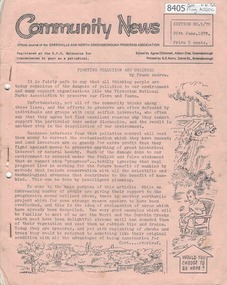
Newsletter, Greenhills and North Greensborough Progress Association, Community News: official journal of the Greenhills and North Greensborough Progress Association. 25th June,1970. Edition No.5/70, 25/06/1970
This edition includes a report on the Progress Association's June 1970 meeting, Councillors report, Fighting pollution and ugliness, How about a community hotel? Some grevilleas for local planting, Further acacias, School and Kinder news, Scout and Guide news, Letters to the editor. A digital copy of this Newsletter is available from Greensborough Historical Society.Newsletter, 18 p., illus. greenhills and north greensborough progress association, greenhills -
 Eltham District Historical Society Inc
Film - Video (VHS), Nillumbik Shire Council, The Nillumbik Story, 1996
PART 1 – NILLUMBIK (00:00-07:17) Opening features various scenes around Nillumbik Shire. For 40,000 years Nillumbik was the home of the Wurundjeri people. Robert Hoddle gave the district its name. Jock Ryan, then president of Nillumbik Historical Society discusses the names Nillumbik and Diamond Creek. In the late 1830s white occupation began with gold found in Warrandyte in 1851 and 12 years later at Diamond Creek -the Diamond Reef which led to the Caledonian gold rush. Jock Ryan discusses the Diamond Creek mine, which was thriving until it burnt out in 1915. Large numbers of workmen moved into area in late 1870s to construct the Maroondah Aqueduct. With growing population of Melbourne, the nearby Yan Yean system had severely disrupted the flow of the Plenty River, forcing the closure of three flour mills there. The aqueduct came to the rescue carrying water 66km from Healesville to Preston. When the Diamond Creek gold mine burnt down the local economy suffered but fruit growing industry had already been established and Diamond Creek became a thriving fruit growing centre. Interview with Jack Powell, a long-time fruiterer at St Andrews market, his family had lived in the area for a hundred years, 3 to 4 generations, “a lot of hard work”. By the time the railway arrived fruit growing was no longer competitive. The railway brought the city closer and day trippers. The Green Wedge separates the shire from the more densely developed neighbours such as Whittlesea, Doncaster, Templestowe, Bulleen and Greensborough. Population at the time (1996) was 19,000 but links to the past remain strong. Mudbrick houses along the Heritage Trail The saving of Shillinglaw Cottage from demolition in 1963 and relocation brick by brick. PART 2 – ENVIRONMENT (07:18-14:44) Peter Brock (with Bev Brock in background) at St Andrews market discusses his childhood growing up in the district and the environment and the values it instilled upon him and his own family. The Brocks have been in the district since the 1860s. Nillumbik Shire responsible for managing three catchment areas; Diamond Creek, Arthurs Creek and Watsons Creek. Follows the course of the Diamond Creek commencing in Kinglake through the district to its confluence with the Yarra River at Eltham at Eltham Lower Park. Highlights Eltham Lower Park community revegetation program and the newly constructed (1996) viewing platform built of new and recycled timbers at the confluence of the Diamond Creek and Yarra River. Also featured are outdoor recreation on the river and at Eltham Lower Park including the Diamond Valley miniature railway. Sugarloaf reservoir and recreational activities and fishing. Aerial view of Memorial Park and Shire of Eltham War Memorial tower at Garden Hill, Kangaroo Ground. Significant tourism opportunities for the shire with 3 million potential day-trippers in metropolitan Melbourne. Council and community working together to find a way to promote the shires natural and artistic assets. At Arthurs Creek, the Brock family and neighbours working together to take care of their waterway. Peter Brock’s uncle, Sandy Brock talks about environmental management and the Arthurs Creek Landcare group and actions to eradicate blackberry problem. Having previously planted Cypress rows they are replacing them with indigenous species to improve the water supply, keeping cattle out of the creek bed to improve the quality downstream flowing into the Yarra. Eltham East Primary School Band playing “All things bright and beautiful” merges into scenes of the bushland sanctuary set aside by the school in 1980 with unidentified teacher discusses the sanctuary and their education program and school children’s comments. Plight of a family of Wedgetail eagles nesting in the path of a developer’s bulldozer at North Warrandyte and actions to save their nesting areas. PART 3 – ARTS (14:45-22:00) Arts and Jazz festival at Montsalvat featuring interviews with Sigmund Jorgensen discussing Montsalvat and its principles. Also Matcham Skipper. Clifton Pugh’s funeral at Montsalvat and his legacy at Dunmoochin near Cottlesbridge with artists in residence, at the time, Chicago artist Charles Reddington who discusses the benefits of the experience. An unidentified female artist also talks about the program and why people are drawn to the area. Unidentified man on street talking about the amount of talent in the area, artists, poets, musicians, authors. Artist Ming Mackay (1918-2009) interviewed talking about the people she mixes with on “the Hill”. Works of local artists are displayed Eltham Library Community Gallery and Wiregrass gallery with a new coffee shop at the Wiregrass making it an even more popular destination. Music at St Andrews Hotel (may be a little bit country) and the Saturday market where likely to hear anything. Sellers and patrons at the market asked about what attracts them to the market and where they came from. Scenes of poets/authors giving readings. CREDITS Music by John Greenfield from the CD Sweet Rain “The Snow Tree”, Uncle Music UNC 2001 Cameras - David Mirabella and Peter Farragher Editor – Olwyn Jones Written and Produced by Jason Cameron A Jason Cameron Proction for Nillumbik ShireProvides a record of the relatively newly created Shire of Nillumbik at the time and the features and attactions of the shire in its people arts, culture and environmentVHS Cassette (five copies) DVD (one copy) Converted to MP4 file format 0:22:00, 1.60GBvideo recording, arthurs creek, arthurs creek landcare group, artists, artists in residence, arts, arts festival, authors, blackberry, brock family, bulldozer, bulleen, bushland sanctuary, caledonian gold rush, charles reddington, clifton pugh, cottlesbridge, cypress rows, developer, diamond creek, diamond creek mine, diamond reef, diamond valley miniature railway, doncaster, dunmoochin, education program, eeps, eltham, eltham east primary school, eltham east primary school band, eltham library community gallery, eltham lower park, environment, fishing, flour mill, fruit growing, fruiterer, garden hill, gold mining, green wedge, greensborough, heritage trail, hurstbridge railway line, jazz festival, jock ryan, kangaroo ground, kangaroo ground tower, kinglake, maroondah aqueduct, matcham skipper, memorial park, ming mackay (1918-2009), montsalvat, mudbrick houses, music, musicians, nesting area, nillumbik historical society, nillumbik shire, north warrandyte, old timer, orchards, peter brock, plenty river, poets, population, recreation, recreational activities, revegetation, robert hoddle, sandy brock, shillinglaw cottage, shire of eltham war memorial, sigmund jorgensen, st andrews hotel, st andrews market, sugarloaf reservoir, templestowe, the hill, tourism, viewing platform, warrandyte, water catchment area, watsons creek, wedgetail eagle, whittlesea, wiregrass gallery, wurundjeri, yarra river, jack powell