Showing 6777 items
matching gully
-
 Eltham District Historical Society Inc
Slide - Photograph, Queenstown Cemetery, Smiths Gully Road, St Andrews, c.2004
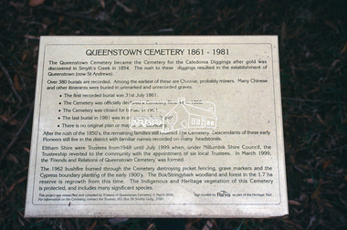
The discovery of gold in Smyth's Creek in 1854 and subsequent gold rush to the Caledonia diggings led to the establishment of Queenstown (present day St Andrews). The first recorded burial was July 31st, 1861 and it was officially declared a Cemetery Reserve in 1866. Many graves are unmarked and unrecorded including many Chinese and other itinerant miners. The cemetery was closed for new burials in 1851. The last recorded burial was in 1981 in an existing family grave.35mm colour positive transparency Mount - white 7 dots (Technodia Italy)queenstown cemetery, smiths gully road, st andrews -
 Eltham District Historical Society Inc
Slide - Photograph, Smiths Gully to St Andrews, Nature History Trail, c.2004
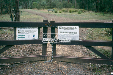
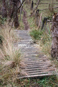
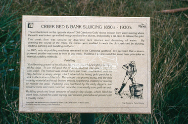
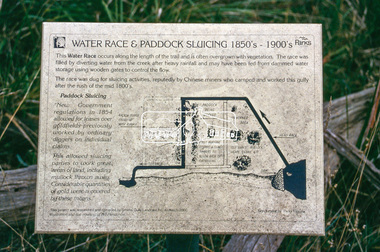
Situated opposite Queenstown Cemetery35mm colour positive transparency Mount - white 7 dots (Technodia Italy)smiths gully road, st andrews, nature history trail, smiths gully -
 Eltham District Historical Society Inc
Slide - Photograph, Smiths Gully to St Andrews, Nature History Trail, c.2004
Situated opposite Queenstown Cemetery35mm colour positive transparency Mount - white 7 dots (Technodia Italy)smiths gully road, st andrews, nature history trail, smiths gully -
 Eltham District Historical Society Inc
Slide - Photograph, Smiths Gully to St Andrews, Nature History Trail, c.2004
Situated opposite Queenstown Cemetery35mm colour positive transparency Mount - white 7 dots (Technodia Italy)smiths gully road, st andrews, nature history trail, smiths gully -
 Eltham District Historical Society Inc
Slide - Photograph, Smiths Gully to St Andrews, Nature History Trail, c.2004
Situated opposite Queenstown Cemetery35mm colour positive transparency Mount - white 7 dots (Technodia Italy)smiths gully road, st andrews, nature history trail, smiths gully -
 Eltham District Historical Society Inc
Slide - Photograph, Smiths Gully to St Andrews, Nature History Trail, c.2004
Situated opposite Queenstown Cemetery35mm colour positive transparency Mount - white 7 dots (Technodia Italy)smiths gully road, st andrews, nature history trail, smiths gully -
 Eltham District Historical Society Inc
Slide - Photograph, Smiths Gully to St Andrews, Nature History Trail, c.2004
Situated opposite Queenstown Cemetery35mm colour positive transparency Mount - white 7 dots (Technodia Italy)smiths gully road, st andrews, nature history trail, smiths gully -
 Eltham District Historical Society Inc
Slide - Photograph, Smiths Gully to St Andrews, Nature History Trail, c.2004
Situated opposite Queenstown Cemetery35mm colour positive transparency Mount - white 7 dots (Technodia Italy)smiths gully road, st andrews, nature history trail, smiths gully -
 Eltham District Historical Society Inc
Slide - Photograph, Smiths Gully to St Andrews, Nature History Trail, c.2004
Situated opposite Queenstown Cemetery35mm colour positive transparency Mount - white 7 dots (Technodia Italy)smiths gully road, st andrews, nature history trail, smiths gully -
 Eltham District Historical Society Inc
Slide - Photograph, Smiths Gully to St Andrews, Nature History Trail, c.2004
Situated opposite Queenstown Cemetery35mm colour positive transparency Mount - white 7 dots (Technodia Italy)smiths gully road, st andrews, nature history trail, smiths gully -
 Eltham District Historical Society Inc
Slide - Photograph, Smiths Gully to St Andrews, Nature History Trail, c.2004
Situated opposite Queenstown Cemetery35mm colour positive transparency Mount - white 7 dots (Technodia Italy)smiths gully road, st andrews, nature history trail, smiths gully -
 Eltham District Historical Society Inc
Slide - Photograph, Smiths Gully to St Andrews, Nature History Trail, c.2004
Situated opposite Queenstown Cemetery35mm colour positive transparency Mount - white 7 dots (Technodia Italy)smiths gully road, st andrews, nature history trail, smiths gully -
 Eltham District Historical Society Inc
Slide - Photograph, Smiths Gully to St Andrews, Nature History Trail, c.2004
Situated opposite Queenstown Cemetery35mm colour positive transparency Mount - white 7 dots (Technodia Italy)smiths gully road, st andrews, nature history trail, smiths gully -
 Eltham District Historical Society Inc
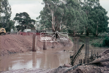
Slide, Construction of new bridge, looking upstream from east bank towards existing Lintons Bridge across Arthurs Creek, Doctors Gully Road, Nutfield, 22 February 1972, 1972
35 mm colour positive transparency Mount - Agfacolor Service (Blue)arthurs creek, bridge construction, doctors gully road, eltham shire council, infrastructure, lintons bridge, nutfield -
 Eltham District Historical Society Inc
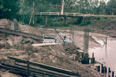
Slide, Construction of new bridge, looking downstream from east bank towards existing Lintons Bridge across Arthurs Creek, Doctors Gully Road, Nutfield, 22 February 1972, 1972
35 mm colour positive transparency Mount - Agfacolor Service (Blue)arthurs creek, bridge construction, doctors gully road, eltham shire council, infrastructure, lintons bridge, nutfield -
 Eltham District Historical Society Inc
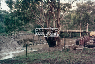
Slide, Construction of new bridge, looking downstream from west bank towards existing Lintons Bridge across Arthurs Creek, Doctors Gully Road, Nutfield, 22 February 1972, 1972
35 mm colour positive transparency Mount - Agfacolor Service (Blue)arthurs creek, bridge construction, doctors gully road, eltham shire council, infrastructure, lintons bridge, nutfield -
 Eltham District Historical Society Inc
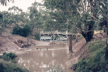
Slide, Construction of new bridge, looking downstream from west bank towards existing Lintons Bridge across Arthurs Creek, Doctors Gully Road, Nutfield, 22 February 1972, 1972
35 mm colour positive transparency Mount - Agfacolor Service (Blue)arthurs creek, bridge construction, doctors gully road, eltham shire council, infrastructure, lintons bridge, nutfield -
 Eltham District Historical Society Inc
Slide, View of Martin's house indicating its relationship to the gully, Bonds Road, Lower Plenty, 18 July 1972, 1972
Water drainage work undertaken by Eltham Shire Council in Bonds Road, Lower Plenty outside the Martin property opposite Montpelier Drive, July 1972 35 mm colour positive transparency Mount - Agfacolor Service (Blue)Bonds Road (Martin property) 12.10 pm 18.7.72bonds road, drainage works, eltham shire council, infrastructure, lower plenty, martin property, montpelier drive -
 Federation University Historical Collection
Photograph - Black and White Photograph, Gold Nugget From White Horse Gully Bendigo, 16/04/1853
Pphotograph of an illustration from teh Illustrated London News 16 April 1853.white horse gully, bendigo, gold nugget -
 Mission to Seafarers Victoria
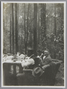
Photograph - Photograph, Black and white, Reverend John Reginald Weller, Picnic to officers & cadets of the S.S. Wentworth, at Sherbrooke Gully, Dec. 1925, December 1925
weller album, sherbrooke, picnics, officers, 1925, cadets -
 Eltham District Historical Society Inc
Photograph, Kinglake National Park, Fern Gully
Source: Mrs. McMinn, Kinglake.This photo forms part of a collection of photographs gathered by the Shire of Eltham for their centenary project book,"Pioneers and Painters: 100 years of the Shire of Eltham" by Alan Marshall (1971). The collection of over 500 images is held in partnership between Eltham District Historical Society and Yarra Plenty Regional Library (Eltham Library) and is now formally known as the 'The Shire of Eltham Pioneers Photograph Collection.' It is significant in being the first community sourced collection representing the places and people of the Shire's first one hundred years.Digital imagesepp, shire of eltham pioneers photograph collection, kinglake, kinglake national park, fern gully -
 Eltham District Historical Society Inc
Photograph, Research Gully Road
Source: Mrs. E.R. Reynolds, Thompson Crescent, ResearchThis photo forms part of a collection of photographs gathered by the Shire of Eltham for their centenary project book,"Pioneers and Painters: 100 years of the Shire of Eltham" by Alan Marshall (1971). The collection of over 500 images is held in partnership between Eltham District Historical Society and Yarra Plenty Regional Library (Eltham Library) and is now formally known as the 'The Shire of Eltham Pioneers Photograph Collection.' It is significant in being the first community sourced collection representing the places and people of the Shire's first one hundred years.Digital imagesepp, shire of eltham pioneers photograph collection, research (vic.), research gully road -
 Eltham District Historical Society Inc
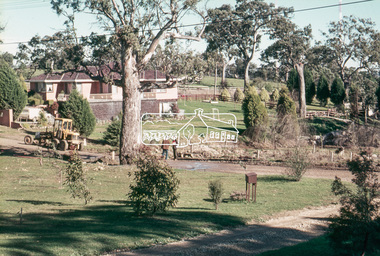
Photograph, Long Gully and environs, Watsons Creek catchment, 23 March 1981, 23/03/1981
Three colour photographslong gully, watsons creek -
 Eltham District Historical Society Inc
Photograph, Doug Orford, Lintons Bridge across Arthurs Creek, Doctors Gully Road, Nutfield, 1991, 1991
From a collection of 35 photos taken by Doug Orford at 35 specific locations along the exact boundary of the then Shire of Eltham.Colour photographbridges, arthurs creek, lintons bridge, nutfield, doctors gully road -
 Eltham District Historical Society Inc
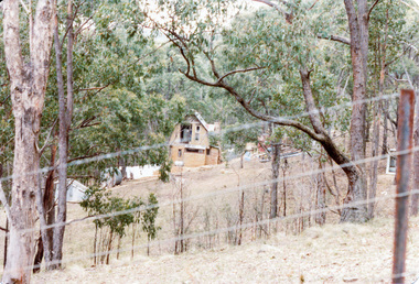
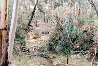
Photograph, Long Gully and environs, Watsons Creek catchment, c.Oct 1982, 1982
Looking for a route for a walking trail from Kinglake to the Yarra River. Not shown is Rod Roscholler. Colour photograph1982, long gully, watsons creek, lodi francesconi, russell yeoman -
 Eltham District Historical Society Inc
Photograph, Long Gully and environs, Watsons Creek catchment, c.Oct 1982, 1982
Colour photograph1982, long gully, watsons creek -
 Eltham District Historical Society Inc
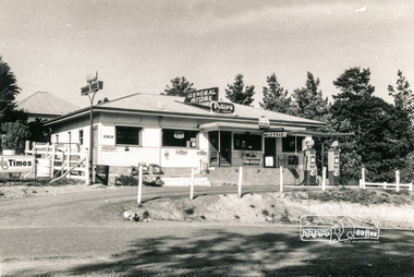
Photograph, General Store, Smiths Gully, 27 Apr. 1968
Black and white photographgeneral store, smiths gully, milk bar, post office, service satation, shops -
 Eltham District Historical Society Inc
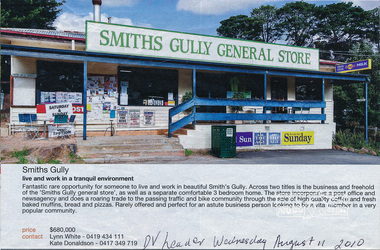
Newspaper clipping, Real Estate for sale; General Store, Smiths Gully, Diamond Valley Leader, 11 Aug 2010, 11/08/2010
Newspaper clippinggeneral store, smiths gully -
 Eltham District Historical Society Inc
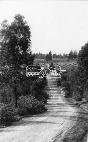
Photograph, Research. Showing top part of present day (1970) Ingrams Road on left. Then research Gully Road
Source: Mrs. E.R. Reynolds, Thompson Crescent, ResearchThis photo forms part of a collection of photographs gathered by the Shire of Eltham for their centenary project book,"Pioneers and Painters: 100 years of the Shire of Eltham" by Alan Marshall (1971). The collection of over 500 images is held in partnership between Eltham District Historical Society and Yarra Plenty Regional Library (Eltham Library) and is now formally known as the 'The Shire of Eltham Pioneers Photograph Collection.' It is significant in being the first community sourced collection representing the places and people of the Shire's first one hundred years.Digital imagesepp, shire of eltham pioneers photograph collection, research (vic.)