Showing 101 items
matching hard drive
-
 Parks Victoria - Andersons Mill
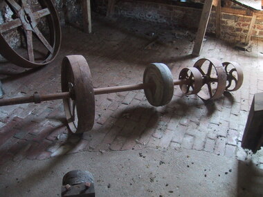
Machine - Shaft, drive
Used to drive the belt for machines.A long shaft with five wheels of varying height attached to it. The largest wheel has six spokes, the second to last in size has five curved spokes. One wheel is made of hard rubber. The shaft extends beyond the largest wheel, where it has a big bolt. The shaft extends an inch or two beyond the wheel at the other end. All wheels are bolted on. -
 University of Melbourne, Burnley Campus Archives
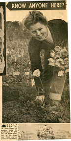
Newspaper - Newspaper Cutting, The Sun, Fewer Girls There Now, 1963
Compares the College of today with the College 29 years ago especially in relation to the proportion of female students.2 copies of Article in "The Sun" July 26, 1963 p22. (1) "Susan Axnick, 18, finds plenty of poppies ready for the picking in the plot she has been tending. In the shops now these are as scarce as vegetables." (2) "Tractors have come these days even to the small plots of the horticulturalist. Here Lawrice Inglis, 17, (1966) drives while Paul Bucknell (1966), 16, left, and Rod Dawson (1966), 17, stand with their shovels ready." (3) "Cathy Taylor (1965), 18, a second year prefect at the school, holds up two cauliflowers of a size that would be hard to buy anywhere today. She grew them herself."lawrice inglis, paul bucknell, rod dawson, cathy taylor, susan axnick, poppies, students working outside, tractor, prefect, cauliflower, orchard -
 Eltham District Historical Society Inc
Photograph - Digital Photograph, Marguerite Marshall, Alan Marshall by Marcus Skipper (1995) outside Eltham Library, Panther Place, Eltham, 11 October 2006
Sculture in bronze of Alan Marshall by Marcus Skipper, 1995 Alan Marshall, AM., O.B.E., Hon.LL,D. (1902-1984) was born at Noorat, Victoria and became one of Australia's most famous authors. His association with the Eltham area began in 1920 when he started his first job as a junior clerk at the Eltham Shire Offices, Kangaroo Ground. In the 1940's he spent some time living at Research. From 1955 he lived in Eltham for nearly 20 years. Disabilities resulting from polio as a young child did not prevent a wide range of experiences. Alan's occupations have been listed as clerk, night watchman, fortune teller, freelance journalist and author. He has been patron of many disadvantaged Children's Societies. Alan's books are numerous and include novels, short stories, children's books, history and travel. Among the best known are his autobiographies "I Can Jump Puddles" and "This is the Grass". Others include "These are My People", "Ourselves Writ Strange", "People of the Dreamtime"; "The Gay Provider" and "Wild Red Horses". In 1971 he wrote the Centenary History of the Shire of Eltham, "Pioneers and Painters". Covered under National Trust of Australia (Victoria), State significance. Published: Nillumbik Now and Then / Marguerite Marshall 2008; photographs Alan King with Marguerite Marshall.; p159 Outside the Eltham Library a bronze figure of a short one-legged man with a crutch invites people to the world of literature. The bronze statue, by Marcus Skipper, is of author Alan Marshall, who is famed for his autobiography I Can Jump Puddles, about growing up and overcoming the effects of polio. That plucky little boy later lived in the Nillumbik district for more than 50 years, and on his death in 1984, was buried in the Nillumbik Cemetery at Diamond Creek. Although a hugely successful author, his grave is modest with only a tiny boulder and simple bronze plaque on a grassed plot. From 1955 to 1972 Marshall lived in a tiny fibro-cement bungalow at the rear of a house at Park West Road, Eltham, owned by his older sister, Elsie McConnell. It was there that he wrote most of his autobiographical trilogy and his history of the former Eltham Shire, Pioneers and Painters. His long association with Eltham Shire began in 1918 when his family moved to Diamond Creek. Then in 1920 he began work as a junior clerk at the Eltham Shire Offices on Main Road, Kangaroo Ground near the Yarra Glen Road, while boarding at the hotel next door. Marshall later bought a block of land in Research, which had three bark huts. In one of these he wrote his first book These Are My People. He later sold the land but lived in a caravan there and in 1955 wrote I Can Jump Puddles.1 Proud of its citizen, the Eltham Shire named a park after Marshall at the corner of Main Road and Leanne Drive, Eltham. In 1985 the Shire initiated the Alan Marshall Short Story Award. It was Marshall’s early life in the country that taught him to live courageously in spite of his crippling polio, and he inspired many. This informed his writing – full of courage, championing the battler and love of the bush. Alan Marshall was born in 1902 at Noorat in Western Victoria, as the only son of Billy a drover, horse breaker, hawker and then general store owner. At the age of six, Marshall contracted infantile paralysis and was later hospitalised in Colac for 18 months. With his father’s encouragement, Marshall learnt to swim, wrestle and box, ride a bicycle (downhill), ride a horse and drive a car. Marshall won a scholarship to Stott’s Correspondence College to study accountancy. To help him continue his studies and find employment, his family bought 12 acres (4.8ha), in Ryans Road, Diamond Creek, opposite Windmill Court. There they ran cows, some poultry and an orchard. But life with a disability and during the Depression was hard for Marshall, who for 20 years, endured long periods of unemployment and loneliness and was often exploited at work.2 However, life improved in the 1930s, when he published short stories and articles in newspapers and magazines, including a column of advice to the lovelorn, which he wrote for nearly 20 years. At age 42 Marshall published his first book and in the next 30 years he published more than 20. His most successful book was I Can Jump Puddles, which sold more than three million copies internationally. It was made into a film, released in 1971, by Czechoslovakian director Karel Kachyna. Marshall was one of the first Australians to write about Aborigines who called him Gurrawilla - teller of tales - when he lived with them in Arnhem Land for eight months.3 In 1941 Marshall married Olive Dixon, with whom he had two daughters, Catherine and Jennifer. Marshall and Olive divorced in 1957. In 1972 Marshall was awarded an OBE for his work with the handicapped. He was also awarded an Honorary Doctor of Laws by Melbourne University, an Order of Australia for services to literature and the Soviet Order of Friendship of Peoples.This collection of almost 130 photos about places and people within the Shire of Nillumbik, an urban and rural municipality in Melbourne's north, contributes to an understanding of the history of the Shire. Published in 2008 immediately prior to the Black Saturday bushfires of February 7, 2009, it documents sites that were impacted, and in some cases destroyed by the fires. It includes photographs taken especially for the publication, creating a unique time capsule representing the Shire in the early 21st century. It remains the most recent comprehenesive publication devoted to the Shire's history connecting local residents to the past. nillumbik now and then (marshall-king) collection, alan marshall, art in public places, eltham, eltham library, marcus skipper, panther place, public art, sculpture -
 Eltham District Historical Society Inc
Photograph - Digital Photograph, Alan King, Blue Lake, Plenty Gorge Park, 2008
A quarry was transformed into the Blue Lake. Published: Nillumbik Now and Then / Marguerite Marshall 2008; photographs Alan King with Marguerite Marshall.; p179 The dramatic steep-sided Plenty Gorge lies along the divide of two geological areas, and separates the Nillumbik Shire and the City of Whittlesea. On the Nillumbik side are undulating hills and sedimentary rock, and in Whittlesea, lies a basalt plain formed by volcanic action up to two million years ago. This provides the Plenty Gorge Park with diverse vegetation and habitats, making it one of Greater Melbourne’s most important refuges for threatened and significant species. The park, established in 1986, consists of around 1350 hectares, and extends 11 kilometres along the Plenty River, from Greensborough to Mernda. It provides a wildlife corridor for around 500 native plant and 280 animal species. The area’s plentiful food and water attracted the Wurundjeri Aboriginal people and then European settlers. By 1837 squatters had claimed large runs of land for their sheep and cattle. The Plenty Valley was among the first in the Port Phillip District to be settled - mainly in the less heavily timbered west - and was proclaimed a settled district in 1841.But by the late 1880s, the settlers’ extensive land clearing for animal grazing, then agriculture, depleted the Wurundjeri’s traditional food sources, which helped to drive them away. Many Wurundjeri artefacts remain (now government protected), and so far 57 sites have been identified in the park, including scarred trees, burial areas and stone artefacts. Pioneer life could be very hard because of isolation, flooding, bushfires and bushrangers. Following the Black Thursday bushfires of 1851, basalt was quarried to build more fire-resistant homes. Gold discoveries in the early 1850s swelled the population, particularly around Smugglers Gully; but food production made more of an impact. In the late 1850s wheat production supplanted grazing. In the 1860s the government made small holdings available to poorer settlers. These had the greatest effect on the district, particularly in Doreen and Yarrambat, where orchards were established from the 1880s to 1914. Links with a prominent early family are the remains of Stuchbery Farm, by the river’s edge bounded by Smugglers Gully to the north and La Trobe Road, Yarrambat, to the east. The Stuchberys moved to the valley in 1890, and the family still lives in the area. In 1890, Alfred and Ada first lived in a tent where four children were born, then Alfred built the house and outbuildings around 1896. They planted an orchard, then a market garden, and developed a dairy. The family belonged to the local Methodist and tennis communities. Their grandson Walter, opened the Flying Scotsman Model Railway Museum in Yarrambat, which his widow, Vi, continues to run. Wal was also the Yarrambat CFA Captain for 22 years until 1987. Walter sold 24 hectares in 1976 for development - now Vista Court - and in 1990, the remaining 22.6 hectares for the park. Remaining are an early stone dairy and remnants of a stone barn, a pig sty and a well. Until it was destroyed by fire in 2003, a slab hut stood on the Happy Hollow Farm site, at the southern end of the park. The hut is thought to have been built in the Depression around 1893. This was a rare and late example of a slab hut with a domestic orchard close to Melbourne. Emmet Watmough and his family first occupied the hut, followed by a succession of families, until the Bell family bought it around 1948. There they led a subsistence lifestyle for 50 years, despite encroaching Melbourne suburbia. The Yellow Gum Recreation Area includes the Blue Lake, coloured turquoise at certain times of the year. Following the 1957 bushfires, this area was quarried by Reid Quarries Pty Ltd for Melbourne’s first skyscrapers, then by Boral Australia. However in the early 1970s water began seeping into the quarry forming the Blue Lake and the quarry was closed. The State Government bought the site in 1997 and opened it as a park in 1999.This collection of almost 130 photos about places and people within the Shire of Nillumbik, an urban and rural municipality in Melbourne's north, contributes to an understanding of the history of the Shire. Published in 2008 immediately prior to the Black Saturday bushfires of February 7, 2009, it documents sites that were impacted, and in some cases destroyed by the fires. It includes photographs taken especially for the publication, creating a unique time capsule representing the Shire in the early 21st century. It remains the most recent comprehenesive publication devoted to the Shire's history connecting local residents to the past. nillumbik now and then (marshall-king) collection, blue lake, plenty gorge park -
 Eltham District Historical Society Inc
Photograph - Digital Photograph, Marguerite Marshall, Stuchbery Farm dairy, 14 March 2008
Stuchbery Farm was situated on the Plenty River bounded by Smugglers Gully to the north and La trobe Road, Yarrambat, to the east. Alan and Ada Stutchbery moved to the valley in 1890, first living in a tent where four children were born. Alfred built a home and outbuildings around 1896. They planted an orchard, then a market garden and developed a dairy. Published: Nillumbik Now and Then / Marguerite Marshall 2008; photographs Alan King with Marguerite Marshall.; p179 The dramatic steep-sided Plenty Gorge lies along the divide of two geological areas, and separates the Nillumbik Shire and the City of Whittlesea. On the Nillumbik side are undulating hills and sedimentary rock, and in Whittlesea, lies a basalt plain formed by volcanic action up to two million years ago. This provides the Plenty Gorge Park with diverse vegetation and habitats, making it one of Greater Melbourne’s most important refuges for threatened and significant species. The park, established in 1986, consists of around 1350 hectares, and extends 11 kilometres along the Plenty River, from Greensborough to Mernda. It provides a wildlife corridor for around 500 native plant and 280 animal species. The area’s plentiful food and water attracted the Wurundjeri Aboriginal people and then European settlers. By 1837 squatters had claimed large runs of land for their sheep and cattle. The Plenty Valley was among the first in the Port Phillip District to be settled - mainly in the less heavily timbered west - and was proclaimed a settled district in 1841. But by the late 1880s, the settlers’ extensive land clearing for animal grazing, then agriculture, depleted the Wurundjeri’s traditional food sources, which helped to drive them away. Many Wurundjeri artefacts remain (now government protected), and so far 57 sites have been identified in the park, including scarred trees, burial areas and stone artefacts. Pioneer life could be very hard because of isolation, flooding, bushfires and bushrangers. Following the Black Thursday bushfires of 1851, basalt was quarried to build more fire-resistant homes. Gold discoveries in the early 1850s swelled the population, particularly around Smugglers Gully; but food production made more of an impact. In the late 1850s wheat production supplanted grazing. In the 1860s the government made small holdings available to poorer settlers. These had the greatest effect on the district, particularly in Doreen and Yarrambat, where orchards were established from the 1880s to 1914. Links with a prominent early family are the remains of Stuchbery Farm, by the river’s edge bounded by Smugglers Gully to the north and La Trobe Road, Yarrambat, to the east. The Stuchberys moved to the valley in 1890, and the family still lives in the area. In 1890, Alfred and Ada first lived in a tent where four children were born, then Alfred built the house and outbuildings around 1896. They planted an orchard, then a market garden, and developed a dairy. The family belonged to the local Methodist and tennis communities. Their grandson Walter, opened the Flying Scotsman Model Railway Museum in Yarrambat, which his widow, Vi, continues to run. Wal was also the Yarrambat CFA Captain for 22 years until 1987. Walter sold 24 hectares in 1976 for development - now Vista Court - and in 1990, the remaining 22.6 hectares for the park. Remaining are an early stone dairy and remnants of a stone barn, a pig sty and a well. Until it was destroyed by fire in 2003, a slab hut stood on the Happy Hollow Farm site, at the southern end of the park. The hut is thought to have been built in the Depression around 1893. This was a rare and late example of a slab hut with a domestic orchard close to Melbourne. Emmet Watmough and his family first occupied the hut, followed by a succession of families, until the Bell family bought it around 1948. There they led a subsistence lifestyle for 50 years, despite encroaching Melbourne suburbia. The Yellow Gum Recreation Area includes the Blue Lake, coloured turquoise at certain times of the year. Following the 1957 bushfires, this area was quarried by Reid Quarries Pty Ltd for Melbourne’s first skyscrapers, then by Boral Australia. However in the early 1970s water began seeping into the quarry forming the Blue Lake and the quarry was closed. The State Government bought the site in 1997 and opened it as a park in 1999.This collection of almost 130 photos about places and people within the Shire of Nillumbik, an urban and rural municipality in Melbourne's north, contributes to an understanding of the history of the Shire. Published in 2008 immediately prior to the Black Saturday bushfires of February 7, 2009, it documents sites that were impacted, and in some cases destroyed by the fires. It includes photographs taken especially for the publication, creating a unique time capsule representing the Shire in the early 21st century. It remains the most recent comprehenesive publication devoted to the Shire's history connecting local residents to the past. nillumbik now and then (marshall-king) collection, ada stuchbery, alan stuchbery, dairy, stuchbery farm, farm buildings, yarrambat, plenty gorge park -
 Warrnambool and District Historical Society Inc.
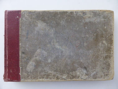
Journal - Book, City Poundkeeper's Book, C 1950
This book records the impounding of animals which have been found wandering on local roads or trespassing on land. Many are farm animals and give the various breeds of animals from red Ayrshire cows to bay ponies, and nanny goats. Impounded animals were either claimed by their owners after payment of a fee or if unclaimed , they were sold. The Warrnambool pound was situated on Merrivale Drive.This book is a record of a practice which was necessary to remove stock which were wandering on local roads or trespassing on neighbours. It contains many local names and is of social interest. Rectangular book with hard cover Fawn cloth with red leather spine. Pages are lined in blue and red and pages are headed in black . It dates from 1957 to 1998 with one entry for 2004.Entries are hand written in blue and black. The entries give particulars of the animal impounded and where found with name of council officer and owner, if known, of the animal.various pieces of paper pasted inside front cover.There are many names included in this journal. Among the earlier entries are James P O'KeefeH C Bidmade, Keith Nixon, C Eccles, I Carmody,warrnambool, warrnambool pound -
 Greensborough Historical Society
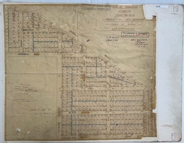
Poster - Planning Document, City of Heidelberg, Subdivision Plan # 19 - Parish of Keelbundoora, Crown Portion 16, Watsonia "Black's subdivision', 1924
Subdivision Plan # 19 - Parish of Keelbundoora, Crown Portion 16, Watsonia "Black's subdivision". This subdivision plan includes proposed street names which were later changed (e.g. Morwell Street (not Morwell Avenue) now called Greenwood Drive). Includes Lambourn Road, Black Street, Grace Street, Eden Avenue, High Street, Kenmare Street, Morwell Avenue, Greensborough Road, Mundy Street, Ladd Street.An example of hard copy subdivision plans from the Greensborough area. Mainly from the Shire of Diamond Valley era (1964-1994).Plan (single sided) mounted on heavy card. Stamped and handwritten Council permissions, dates and other details. subdivision plans, city of heidelberg, greensborough, main street greensborough, shire of heidelberg, watsonia, black family -
 Bendigo Historical Society Inc.
Photograph - AUSTIN COLLECTION: Ray Beer, Central Deborah Gold Mine
Ray Beer was an employee of the Central Deborah Gold Mine. February 15th 2009: Bendigo Advertiser: 'MINING stalwart Raymond Beer has died at the age of 74 after a battle with cancer. He leaves behind an extended family and a legacy in Bendigo’s mining history. Ray was mine manager at the Central Deborah Gold Mine - appointed in 1978 - and led the team that made possible the underground project at the second level. He had a vision to allow visitors to go underground and experience Bendigo’s mining heritage first hand. Ray was responsible for developing the new battery, shaft and poppet head to make this a reality. It took persistence and lots of hard work. Friend and work colleague Bill McNamara said Ray was as good as 10 men. His enthusiasm and work ethic were unprecedented. Ray will be sadly missed by his wife, Thelma, six children, 15 grandchildren, seven brothers, three sisters, his extended family, and friends. He will be remembered for his kindness, tenacity and strength of character. In recognition of his contribution to Bendigo’s mining history, after more than 20 years of service at his retirement, a bronze life-sized statue was unveiled in his honour'. Central Deborah Gold Mine history: At its peak, Central Deborah Gold Mine reached a depth of 412 metres. It has 17 separate levels and 15 kilometres of drives and cross cuts (tunnels). The Central Deborah was very much a hands-on mine and the conditions that the miners worked in would be considered shocking by today's standards – being lowered underground in a cage with only two sides, often working ankle to knee deep in water, filling up to 32 ore trucks a shift by hand which were then pushed a mile or more along rails in the drives, working by carbide lamp, breathing in the fumes and rock dust and communication by bells. Geez, they were ironmen. However, at the time working conditions were considered to be among the best on the goldfields at Central Deborah, after all it was one of the only mines that had hot showers. Following Central Deborah Gold Mine's closure, the Bendigo skyline began to noticeably change. Obvious remnants of mining such as poppet heads, engine rooms, service quarters, battery houses and chimneys were steadily disappearing. After intense lobbying by the local community, the Bendigo City Council purchased the still very much intact Central Deborah Gold Mine in 1970 for a mere $6,000 to ensure that a vital link to Bendigo's historic golden past was maintained. The Bendigo Trust was then formed to oversee the operations of the Central Deborah Gold Mine, which led to the surface of the mine being opened to the public in 1971. Initially the surface was open for just 12 hours a week and as the demand for viewing a part of Bendigo's history increased, so did the opening hours. In 1974 the mine was gazetted as a Public Historical Purposes Reserve and attracted such visitors as H.R.H Prince Charles. By far the greatest shortcoming at this stage was that no one could view the underground workings, as these had become flooded. After what could only be described as a monumental effort by everyone involved, Level 2 of the mine was officially opened to the public by the Premier of Victoria, the Honourable John Cain, on 20 June 1986, which brought to fruition a long standing dream.Black and white photograph. Ray Beer, underground at Central Deborah Gold Mine, standing alongside wooden sign 'Murrell's Corner'. Sign is placed horizontally on timber supports; side of drive visible in background. Ray is wearing bib and brace overalls and hard hat with a belt around his waist. He is giving a 'thumbs up' sign. gold mining, central deborah gold mine, ray beer, mine manager -
Bendigo Historical Society Inc.
Photograph - AUSTIN COLLECTION: Central Deborah Gold Mine, Possibly 1990's
Central Deborah Gold Mine history: At its peak, Central Deborah Gold Mine reached a depth of 412 metres. It has 17 separate levels and 15 kilometres of drives and cross cuts (tunnels). The Central Deborah was very much a hands-on mine and the conditions that the miners worked in would be considered shocking by today's standards – being lowered underground in a cage with only two sides, often working ankle to knee deep in water, filling up to 32 ore trucks a shift by hand which were then pushed a mile or more along rails in the drives, working by carbide lamp, breathing in the fumes and rock dust and communication by bells. Geez, they were ironmen. However, at the time working conditions were considered to be among the best on the goldfields at Central Deborah, after all it was one of the only mines that had hot showers. Following Central Deborah Gold Mine's closure, the Bendigo skyline began to noticeably change. Obvious remnants of mining such as poppet heads, engine rooms, service quarters, battery houses and chimneys were steadily disappearing. After intense lobbying by the local community, the Bendigo City Council purchased the still very much intact Central Deborah Gold Mine in 1970 for a mere $6,000 to ensure that a vital link to Bendigo's historic golden past was maintained. The Bendigo Trust was then formed to oversee the operations of the Central Deborah Gold Mine, which led to the surface of the mine being opened to the public in 1971. Initially the surface was open for just 12 hours a week and as the demand for viewing a part of Bendigo's history increased, so did the opening hours. In 1974 the mine was gazetted as a Public Historical Purposes Reserve and attracted such visitors as H.R.H Prince Charles. By far the greatest shortcoming at this stage was that no one could view the underground workings, as these had become flooded. After what could only be described as a monumental effort by everyone involved, Level 2 of the mine was officially opened to the public by the Premier of Victoria, the Honourable John Cain, on 20 June 1986, which brought to fruition a long standing dream.Black and white photograph. Two men with hard hats and lights, inspecting quartz outcrop on wall of drive at Central Deborah Gold Mine.gold mining, central deborah gold mine, ray beer, mine manager -
Bendigo Historical Society Inc.
Photograph - AUSTIN COLLECTION: Quartz vein, Central Deborah Gold Mine, Possibly 1990's
Black and white photograph. Underground miner, wearing hard hat and light, inspecting a quartz vein on the wall of a drive at the William's United Gold Mine, Eaglehawk. On back of photo: ' Ian Clark, 8" drill hole'and drill holegold mining, central deborah gold mine, underground, quartz vein, williams united gold mine, eaglehawk -
Eltham District Historical Society Inc
Document - Folder, Smith, Isa Bernhard
Isa grew up near Tyntynder, Swan Hill. After she married they lived at Nerreman Park, eventually building their own house. Contents Newspaper article: "Isa's hard work pays off", Diamond Valley News, 17 December 1985. Biography of Isa Smith. Newspaper clippings, A4 photocopies, etcisa bernhard smith, ryans road eltham, karringal drive eltham, nerreman creek, west main drain eltham, war memorial trust eltham, st margaret's church eltham, eltham pony club, whelan the wrecker, prahran technical college, melbourne grammar school