Showing 177 items
matching harden
-
 Ringwood and District Historical Society
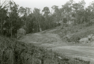
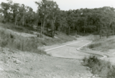
Photographs, 1979-80 MMBW pipe line project at Hubbard Reserve, North Ringwood � View east up the gully
Part of a 43-photo record of the MMBW�s engineering feat in drilling a 12 inch pipe line up to 40 feet deep through rock hardened by volcanic action associated with geological fault that occurs along the line. The work took place from October 1979 to May 1980 on the southern boundary of Hubbard Reserve, North Ringwood. The collection was presented to the Ringwood Historical Research Group by J Clarke on 9th June 1980.E568 N19 13 May 1980 A43 View east up the gully, when all the work was finished -
 Ringwood and District Historical Society
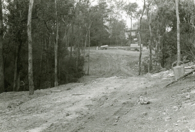
Photographs, 1979-80 MMBW pipe line project at Hubbard Reserve, North Ringwood � Looking east near Debbie Place
Part of a 43-photo record of the MMBW�s engineering feat in drilling a 12 inch pipe line up to 40 feet deep through rock hardened by volcanic action associated with geological fault that occurs along the line. The work took place from October 1979 to May 1980 on the southern boundary of Hubbard Reserve, North Ringwood. The collection was presented to the Ringwood Historical Research Group by J Clarke on 9th June 1980.E567 N16 13 May 1980 A43 Looking east from the ridge above Debbie Place. The finished manhole is in the gully. -
 Ringwood and District Historical Society
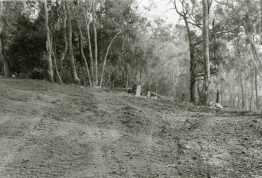
Photographs, 1979-80 MMBW pipe line project at Hubbard Reserve, North Ringwood � View east from Debbie Place
Part of a 43-photo record of the MMBW�s engineering feat in drilling a 12 inch pipe line up to 40 feet deep through rock hardened by volcanic action associated with geological fault that occurs along the line. The work took place from October 1979 to May 1980 on the southern boundary of Hubbard Reserve, North Ringwood. The collection was presented to the Ringwood Historical Research Group by J Clarke on 9th June 1980.E558 N29 13 May 1980 A43 View east from Debbie Place -
 Ringwood and District Historical Society
Photographs, 1979-80 MMBW pipe line project at Hubbard Reserve, North Ringwood � Track down to creek bridge
Part of a 43-photo record of the MMBW�s engineering feat in drilling a 12 inch pipe line up to 40 feet deep through rock hardened by volcanic action associated with geological fault that occurs along the line. The work took place from October 1979 to May 1980 on the southern boundary of Hubbard Reserve, North Ringwood. The collection was presented to the Ringwood Historical Research Group by J Clarke on 9th June 1980.E565 N12 13 May 1980 A43 My old track down to the bridge over the creek. The pipe line went to the right of the big tree 40-foot down. -
 Ringwood and District Historical Society
Photographs, 1979-80 MMBW pipe line project at Hubbard Reserve, North Ringwood � The new trach goes on down to Debbie Place
Part of a 43-photo record of the MMBW�s engineering feat in drilling a 12 inch pipe line up to 40 feet deep through rock hardened by volcanic action associated with geological fault that occurs along the line. The work took place from October 1979 to May 1980 on the southern boundary of Hubbard Reserve, North Ringwood. The collection was presented to the Ringwood Historical Research Group by J Clarke on 9th June 1980.E566 N13 13 May 1980 A43 The parting of the ways. My old track goes left to Burlock Avenue. The new way goes on down to Debbie Place. -
 Ringwood and District Historical Society
Photographs, 1979-80 MMBW pipe line project at Hubbard Reserve, North Ringwood � Manhole behind 29 Burlock Avenue
Part of a 43-photo record of the MMBW�s engineering feat in drilling a 12 inch pipe line up to 40 feet deep through rock hardened by volcanic action associated with geological fault that occurs along the line. The work took place from October 1979 to May 1980 on the southern boundary of Hubbard Reserve, North Ringwood. The collection was presented to the Ringwood Historical Research Group by J Clarke on 9th June 1980.E566 N5 13 May 1980 A43 Manhole behind 29 Burlock Avenue, 38 feet deep. Debbie place is on the far right. -
 Ringwood and District Historical Society
Photographs, 1979-80 MMBW pipe line project at Hubbard Reserve, North Ringwood � The manhole in the creek
Part of a 43-photo record of the MMBW�s engineering feat in drilling a 12 inch pipe line up to 40 feet deep through rock hardened by volcanic action associated with geological fault that occurs along the line. The work took place from October 1979 to May 1980 on the southern boundary of Hubbard Reserve, North Ringwood. The collection was presented to the Ringwood Historical Research Group by J Clarke on 9th June 1980.E563 1 April 1980 A43 The manhole in the creek, waiting until boring is finished. -
 Ringwood and District Historical Society
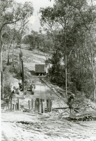
Photographs, 1979-80 MMBW pipe line project at Hubbard Reserve, North Ringwood � Tracked drill rig
Part of a 43-photo record of the MMBW�s engineering feat in drilling a 12 inch pipe line up to 40 feet deep through rock hardened by volcanic action associated with geological fault that occurs along the line. The work took place from October 1979 to May 1980 on the southern boundary of Hubbard Reserve, North Ringwood. The collection was presented to the Ringwood Historical Research Group by J Clarke on 9th June 1980.E561 N16 3 March 1980 A43 Tracked drill rig on the line of trench for sewer to Debbie Place -
 Ringwood and District Historical Society
Photographs, 1979-80 MMBW pipe line project at Hubbard Reserve, North Ringwood � Air track drill rig
Part of a 43-photo record of the MMBW�s engineering feat in drilling a 12 inch pipe line up to 40 feet deep through rock hardened by volcanic action associated with geological fault that occurs along the line. The work took place from October 1979 to May 1980 on the southern boundary of Hubbard Reserve, North Ringwood. The collection was presented to the Ringwood Historical Research Group by J Clarke on 9th June 1980.E561 N19 3 March 1980 A43 Air track drill rig in position as in N18 -
 Ringwood and District Historical Society
Photographs, 1979-80 MMBW pipe line project at Hubbard Reserve, North Ringwood � Last days of the boring
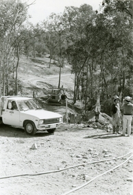
Part of a 43-photo record of the MMBW�s engineering feat in drilling a 12 inch pipe line up to 40 feet deep through rock hardened by volcanic action associated with geological fault that occurs along the line. The work took place from October 1979 to May 1980 on the southern boundary of Hubbard Reserve, North Ringwood. The collection was presented to the Ringwood Historical Research Group by J Clarke on 9th June 1980.E561 N1 1 April 1980 A43 Last days of the boring. The mole had broken between the last two shafts. Dominic Di Nezza and Glen Pearson discuss further moves to release it. -
 Ringwood and District Historical Society
Photographs, 1979-80 MMBW pipe line project at Hubbard Reserve, North Ringwood � Drill rig
Part of a 43-photo record of the MMBW�s engineering feat in drilling a 12 inch pipe line up to 40 feet deep through rock hardened by volcanic action associated with geological fault that occurs along the line. The work took place from October 1979 to May 1980 on the southern boundary of Hubbard Reserve, North Ringwood. The collection was presented to the Ringwood Historical Research Group by J Clarke on 9th June 1980.E561 N17 3 March 1980 A43 Powder-monkey marks out the spots for holes -
 Ringwood and District Historical Society
Photographs, 1979-80 MMBW pipe line project at Hubbard Reserve, North Ringwood � View towards Debbie Place
Part of a 43-photo record of the MMBW�s engineering feat in drilling a 12 inch pipe line up to 40 feet deep through rock hardened by volcanic action associated with geological fault that occurs along the line. The work took place from October 1979 to May 1980 on the southern boundary of Hubbard Reserve, North Ringwood. The collection was presented to the Ringwood Historical Research Group by J Clarke on 9th June 1980.E561 N15 3 March 1980 A43 View towards Debbie Place, showing 2 swivel cranes at shafts, timber of manhole in creek, the tracked drill rig and its compressor caravan. -
 Ringwood and District Historical Society
Photographs, 1979-80 MMBW pipe line project at Hubbard Reserve, North Ringwood � Boring mole pit
Part of a 43-photo record of the MMBW�s engineering feat in drilling a 12 inch pipe line up to 40 feet deep through rock hardened by volcanic action associated with geological fault that occurs along the line. The work took place from October 1979 to May 1980 on the southern boundary of Hubbard Reserve, North Ringwood. The collection was presented to the Ringwood Historical Research Group by J Clarke on 9th June 1980.E561 N14 3 March 1980 A43 View west behind No. 29 Burlock Avenue, showing gantry over manhole 38 feet deep. -
 Ringwood and District Historical Society
Photographs, 1979-80 MMBW pipe line project at Hubbard Reserve, North Ringwood � The work on sewer line from 29-39 Burlock Avenue
Part of a 43-photo record of the MMBW�s engineering feat in drilling a 12 inch pipe line up to 40 feet deep through rock hardened by volcanic action associated with geological fault that occurs along the line. The work took place from October 1979 to May 1980 on the southern boundary of Hubbard Reserve, North Ringwood. The collection was presented to the Ringwood Historical Research Group by J Clarke on 9th June 1980.E561 N11 3 March 1980 A43 The work on sewer line from 29-39 Burlock Avenue. Lundy-Clarke's place on sky-line. -
 Ringwood and District Historical Society
Photograph, 1979-80 MMBW pipe line project at Hubbard Reserve, North Ringwood. Debbie Place from the east end
Part of a 43-photo record of the MMBW's engineering feat in drilling a 12 inch pipe line up to 40 feet deep through rock hardened by volcanic action associated with geological fault that occurs along the line. The work took place from October 1979 to May 1980 on the southern boundary of Hubbard Reserve, North Ringwood. The collection was presented to the Ringwood Historical Research Group by J Clarke on 9th June 1980.E550 N12 Dec 1979 A43 Debbie Place from the east end -
 Ringwood and District Historical Society
Photographs, 1979-80 MMBW pipe line project at Hubbard Reserve, North Ringwood � View from Debbie Place, preliminary sewer work
Part of a 43-photo record of the MMBW�s engineering feat in drilling a 12 inch pipe line up to 40 feet deep through rock hardened by volcanic action associated with geological fault that occurs along the line. The work took place from October 1979 to May 1980 on the southern boundary of Hubbard Reserve, North Ringwood. The collection was presented to the Ringwood Historical Research Group by J Clarke on 9th June 1980.E561 N13 28 Feb 1980 A43 View from Debbie Place, preliminary sewer work -
 Ringwood and District Historical Society
Photographs, 1979-80 MMBW pipe line project at Hubbard Reserve, North Ringwood � Line of tunnel shafts behind 29-39 Burlock Avenue
Part of a 43-photo record of the MMBW�s engineering feat in drilling a 12 inch pipe line up to 40 feet deep through rock hardened by volcanic action associated with geological fault that occurs along the line. The work took place from October 1979 to May 1980 on the southern boundary of Hubbard Reserve, North Ringwood. The collection was presented to the Ringwood Historical Research Group by J Clarke on 9th June 1980.E561 N10 Feb 1980 A43 Line of tunnel shafts behind 29-39 Burlock Avenue. Horizontal gantry was above the manhole in the corner of No. 29. -
 Ringwood and District Historical Society
Photographs, 1979-80 MMBW pipe line project at Hubbard Reserve, North Ringwood � First hole west of bore hole at 39 Burlock Avenue
Part of a 43-photo record of the MMBW�s engineering feat in drilling a 12 inch pipe line up to 40 feet deep through rock hardened by volcanic action associated with geological fault that occurs along the line. The work took place from October 1979 to May 1980 on the southern boundary of Hubbard Reserve, North Ringwood. The collection was presented to the Ringwood Historical Research Group by J Clarke on 9th June 1980.E561 N9 Feb 1980 A43 First hole west of bore hole at 39 Burlock Avenue -
 Port Melbourne Historical & Preservation Society
Document - Certificate of Marriage George QUICK & Rosa Harden HARRIS, 29 Sep1858
Rosa Harden HARRIS married George Quick at St Peters, Melbourne on the 29th December 1858. George was born in New York and his father, Joseph, was a Cordwainer. Rosa had been born in London and her parents were Jane RINTOUL and John Mark HARRIS, a silversmith. One of the witnesses was Rosa's sister, Charlotte Elizabeth HARRIS, who was to marry John LOWE. Rosa went on to own a two story brick shop and dwelling on the corner of Dow & Graham Streets, Port Melbourne. Pale blue Original Certificate of Marriage No. 1044 celebrated at St Peters church, Melbourne.graham street, john lowe, rosa harden quick, rosa harden harris, george quick, celebrations- weddings, charlotte elizabeth harris, joseph quick, jane rintoul, john mark harris -
 Royal Australian and New Zealand College of Obstetricians & Gynaecologists (RANZCOG)
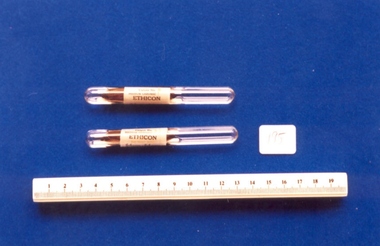
Two glass vials of 'Ethicon' catgut #3 used by Dr Mitchell Henry O'Sullivan, Ethicon
Tanned or chronic catgut came from top quality catgut (fat free). A hardening process was then applied to the muscle durations. The process was introduced and perfected by the firm of Mersons of Edinburgh, makers of sterile surgical ligatures in the early 1930s. Once processed the catgut was preserved in an iod-asceptic preserving spirit and hermetically sealed in glass tubes. It was completely sterile and ready for immediate use. The length of the catgut in each tube was five feet, or 2.5m, and could be wound onto glass winders in assorted colours.Dr Mitchell Henry O'Sullivan worked in the Victorian country town of Casterton as a general practitioner from 1919 until his death in 1977. He also practiced obstetrics. His son, Dr David More O'Sullivan donated his obstetric bag and its contents to the College in 1999. The bag and contents are a unique time capsule of the type of instruments and pharmaceuticals used in the inter-war period.Two glass vials [195.1,.3] with catgut number three "Ethicon" [195.2,.4] in sterile solution. Vials are moulded and sealed at both ends.obstetric delivery -
Clunes Museum
Memorabilia - PRIZE CARDS/CLOTH BAG
.1 PRIZE CARD BACK TO CLUNES EASTER 1972 FIRST PRIZE AWARDED TO JOANNE FAWCETT FOR BEST DECORATED PRAM SIGNED BY JT HARDEN, PRESIDENT, JEAN PEART SECRETARY .2 PRIZE CARD BACK TO CLUNES EASTER 1972 FIRST PRIZE AWARDED TO MECHANICAL ROUGH RIDER FOR MOST UNUSUAL SIGNED BY JT HAYDEN PRESIDENT, JEAN PEART SECRETARY .3 CLOTH BAG, WHITE COTTON BAG WITH EMBLEM ON FRONT THREE BEARS PORRIDGE, ROLLED OATS, 5 LBS.NETback to clunes, easter 1972, tthree bears porridge -
 Tennis Australia
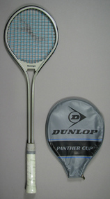
Racquet & cover, Circa 1982
A Slazenger, Panther Cup squash racquet (1), with vinyl racquet head cover, featuring the Dunlop brand logo and trademark (2), since both brands were owned by the same company at this time. Racquet primarily comprises of a frame made from a singular piece of tubular metal, secured by a plastic bridge across the throat, and the hardened plastic handle below. Materials: Metal, Plastic, Synthetic material, Ink, Nylon, Vinyl, Synthetic material, Ink, Plastic, Metaltennis -
Clunes Museum
Photograph, Harvey Photo, 1979
Members; L Davis, T Weatherly, A Ross, K Thompson, J Hill, L Torney, H Adams, R Hood, B Anderson, D Pearce, K Harper, K Ridley, J Engelen, I Mahar, R Andrews, J Millar, B Engelen, A G Leishman, N Harling, R Torney, C Sullivan, H O'Toole, K Kinnersley, T Harden, R Donal, F Gilders, D Hill (Pres), K Robinson, G Lear, W Birch, A G McLennan, H SaintColoured photograph mounted on buff coloured card of members of Clunes Bowling clubOn front printed in black ink; Clunes Bowling club Centenary Year 1879-1979 On reverse; J Toole paid clunes bowling club, 1879-1979 -
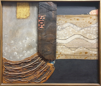 Federation University Art Collection
Mixed media - Collage, 'The' by Elwyn Lynn, 1968
Elwyn (Jack) LYNN (6 November 1917 – 22 January 1997) Born Canowindra, New South Wales Sydney based artist Elwyn Lynn was a self-taught artist who often used unconventional painting media and expressive surfaces to create abstract work. He trained as a teacher, and was a teacher of English and History in Sydney Secondary schools until 1968. From 1969 to 1983 Elwynn Lynn was Curator of the Power Gallery of Contemporary Art at Sydney University where he built up an international collection, which is now within the Sydney Museum of Contemporary Art. He was an art critic at The Australian for many years, and wrote several books, including one on the artist Sir Sidney Nolan. Elwyn Lynn was awarded Membership of the Order of Australia in 1975. He won the Wynne Prize at the Art Gallery of NSW in 1988, received an Honorary Doctor of Letters from the University of Sydney in 1969, and received the Emeritus Award from the Australia Council in 1994. This item is part of the Federation University Art Collection. The Art Collection features over 2000 works and was listed as a 'Ballarat Treasure' in 2007.Framed mixed media artwork. Like most of Elwyn Lynn's work 'The' is essentially abstract, although evoking a sense of landscape. " Lynn’s heavy textures were created by mixing polyvinyl acetate (PVA) with sand, cement or plaster, after which it was left to dry in the sun or near a radiator. With the upper level drying and hardening first, its skin could be cut, sliced, poked, prodded and distressed, pushed into folds and corrugations." (https://www.charlesnodrumgallery.com.au/artists/elwyn-lynn/elwyn-lynn/, accessed 22 October 2019)art, artwork, elwyn lynn, abstract, available -
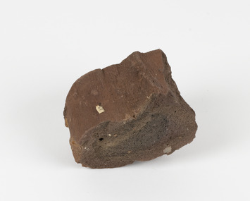 The Beechworth Burke Museum
Geological specimen - Ropy Lava
‘Ropy lava’ is known for its sculptural and layered qualities. It occurs in specific lava flows that are slow moving and slow cooling, allowing for unique formations to be created out of the motion. Ropy Lava is a flow that has a hardened crust with molten material underneath, the tension between these states is what creates its characteristic form. The brown/red hue of the stone is an indication of age, as it is oxidised iron deposits. This rock deposit is thought to be sourced from the area by Talbot, in western Victoria. This area has a rich mineral history and experienced the gold rush in the 1850's. The traditional owners of this area are the Dja Dja Wurrung people.This geological specimen shows the conditions in which the Australian landscape was created as well as provides an indication as to how these events occurred. It is representative of a common natural process that contextualises the formation of Australia with the formation of other landmasses. This specimen is part of a larger collection of geological and mineral specimens collected from around Australia (and some parts of the world) and donated to the Burke Museum between 1868-1880. A large percentage of these specimens were collected in Victoria as part of the Geological Survey of Victoria that begun in 1852 (in response to the Gold Rush) to study and map the geology of Victoria. Collecting geological specimens was an important part of mapping and understanding the scientific makeup of the earth. Many of these specimens were sent to research and collecting organisations across Australia, including the Burke Museum, to educate and encourage further study.Hand sized specimen in brown/red hues42 / victoria, talbot, lava, ropy, ropy lava, mineral, geological specimen, geological, geological heritage, natural stone, natural history -
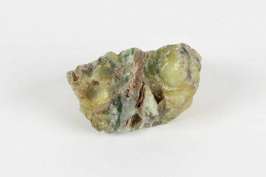 The Beechworth Burke Museum
Geological specimen - Common Opal, Unknown
It is not known where this opal originated. Common Opal is formed from silica-rich water entering the earths crust and hardening into a gel of water and silica-spheres, layered through the specimen. Common opal differs from precious opal in colouration and appearance, with precious opal including more colours, and having a translucent or glossy appearance, where common opal shows less colour and is typically opaque. It scores high on the Mohs hardness scale, and is common throughout the world, especially in Australia, where it is far more prevalent than the highly-prized precious opal. Australia is also the highest producer of opals in the modern world. This specimen is part of a larger collection of geological and mineral specimens collected from around Australia (and some parts of the world) and donated to the Burke Museum between 1868-1880. A large percentage of these specimens were collected in Victoria as part of the Geological Survey of Victoria that begun in 1852 (in response to the Gold Rush) to study and map the geology of Victoria. Collecting geological specimens was an important part of mapping and understanding the scientific makeup of the earth. Many of these specimens were sent to research and collecting organisations across Australia, including the Burke Museum, to educate and encourage further study.A solid, silica-based mineral specimen of Common Opal in shades of grey, green, and yellow, with a thick grey vein running through the centre. geological specimen, geology, geology collection, burke museum, beechworth, opal, common opal, gemstone, mining -
 Ringwood and District Historical Society
Photographs, 1979-80 MMBW pipe line project at Hubbard Reserve, North Ringwood � Back-hoe at pit
E560 N6 Dec 1979 A43 The back-hoe works on the beginnings of pit in 39 Burlock Avenue backyard Part of a 43-photo record of the MMBW�s engineering feat in drilling a 12 inch pipe line up to 40 feet deep through rock hardened by volcanic action associated with geological fault that occurs along the line. The work took place from October 1979 to May 1980 on the southern boundary of Hubbard Reserve, North Ringwood. The collection was presented to the Ringwood Historical Research Group by J Clarke on 9th June 1980. -
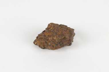 The Beechworth Burke Museum
Geological specimen - Laterite
Laterite refers to both a rock and a soil type that is rich in clay, as well as Iron and Aluminium. It is created during a process that is called laterization, where high heat and seasonal heavy rainfall cause there to be wet and dry periods, which over time hardens the soil into rock. Because of this, most laterite is formed between tropics of Cancer and Capricorn. The iron oxide in laterite is what gives it it’s orange-red colouring. The largest religious complex in the world, Angkor Wat in Cambodia, is partially constructed of laterite, particularly its foundations, as laterite is porous and allows rainwater to drain. This specimen of laterite was collected from the Democratic Republic of Congo while it was colonised by Belgium in the 19th century. Laterite forms in many parts of the world, particularly between the tropics. It is used both for ore and as a building material, and comparing specimens from different parts of the world allows us to document the different compositions that this mineral can have when formed at different locations. This specimen is part of a larger collection of geological and mineral specimens collected from around Australia (and some parts of the world) and donated to the Burke Museum between 1868-1880. A large percentage of these specimens were collected in Victoria as part of the Geological Survey of Victoria that begun in 1852 (in response to the Gold Rush) to study and map the geology of Victoria. Collecting geological specimens was an important part of mapping and understanding the scientific makeup of the earth. Many of these specimens were sent to research and collecting organisations across Australia, including the Burke Museum, to educate and encourage further study.a palm-sized solid iron-aluminium oxide mineral specimen in shades of brown, orange and greyburke museum, beechworth, geological, geological specimen, laterite, laterite specimen, geology -
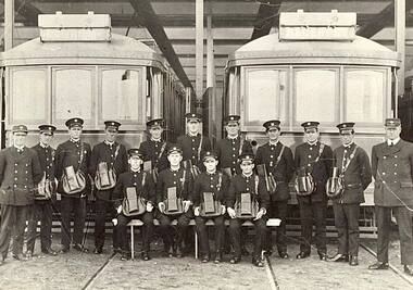 Melbourne Tram Museum
Photograph - Digital Image, State Library of Victoria, "FNPTT Conductors and Inspectors", 1/11/2021 12:00:00 AM
Digital image with Email titled "FNPTT Conductors and Inspectors", dated 1/11/2021 forwarding an image of Fitzroy Northcote and Preston Tramways Trust Staff c1920. Image from the State Library of Victoria. Lists the staff in the photo. Photo of crews standing in front of two trams at the Preston (Thornbury) Depot with their Conductors bags.trams, tramways, fnptt, conductors, inspectors, crews, preston depot, thornbury depot -
 Ringwood and District Historical Society
Photographs, 1979-80 MMBW pipe line project at Hubbard Reserve, North Ringwood � Boring mole pit
E560 N5 Dec 1979 A43 Boring mole pit near big box tree in 39 Burlock Avenue backyard Part of a 43-photo record of the MMBW�s engineering feat in drilling a 12 inch pipe line up to 40 feet deep through rock hardened by volcanic action associated with geological fault that occurs along the line. The work took place from October 1979 to May 1980 on the southern boundary of Hubbard Reserve, North Ringwood. The collection was presented to the Ringwood Historical Research Group by J Clarke on 9th June 1980.