Showing 2918 items matching "highways"
-
 Lakes Entrance Historical Society
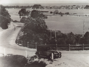
Photograph - Princes Highway around Jemmys Point, Lakes Entrance, H D Bulmer, 1930 c
Princes Highway around Jemmys Point, car parked on road at junction of original steep road to top of Jemmys Point. Man on bicycle riding up hill. Bullock Island and New Works in distance over North Arm and Cunninghame Arm waterways Lakes Entrance VictoriaBlack and white photograph of lower section of Princes Highway around Jemmys Point, car parked on road at junction of original steep road to top of Jemmys Point. Man on bicycle riding up hill. Bullock Island and New Works in distance over North Arm and Cunninghame Arm waterways Lakes Entrance Victoriaroads and streets, township, waterways, fences, vehicles -
 Orbost & District Historical Society
black and white photographs, 1915
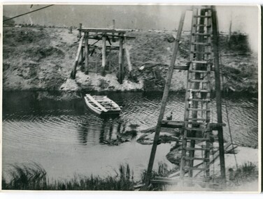
This photograph is of the construction of the first road bridge over the Genoa River - 1915. Before today's timber truss and concrete bridge was constructed between 1926-1928 by contractor J.T. Noble Anderson, two earlier bridges crossed the Genoa River at this location. They provided crucial links in the Princes Highway route from Melbourne to Sydney. The letter on the back of the postcard was written by Gordon ? to Alex ? on 2nd October 1917. "this represents the opening of Genoa Bridge. Mrs Alexander cutting the ribbon and Mr Martin holding it at the other side. Did most of the speaking. The gent holding the roll of paper is who came to open the bridge. I can't think of his name. Hubert is standing up at the right / Gordon " This is a pictorial record associated with the history of Genoa in East Gippsland.1100 -A large black / white photograph on a cream coloured buff card. It is of an unfinished bridge with men working there. A small rowboat can be seen on the far side of the river. 1100.1 - A photograph / postcard of the opening of "Genoa Bridge 1917". There is a ribbon stretched across the timber decking road in front of a group of people. 1100.2 - A black / white photograph of a road bridge across a river.on back - "Princes Highway - the 1st bridge over the Genoa River - 1915" on back of 1100.1 is a hand-written letter.genoa-bridge princes-highway-east-gippsland -
 Whitehorse Historical Society Inc.
Article, Burwood Highway, 29/01/1992 12:00:00 AM
Burwood Highway is official.(official name change)Burwood Highway is official.(official name change)Burwood Highway is official.(official name change)burwood highway, roads and streets -
 Whitehorse Historical Society Inc.
Photograph - Black and white photograph, Royal Visit 1954
Royal visit 1954 . Decorations in Whitehorse Road Mitcham.Maroondah highway showing decorations looking South.royal visit 1954, maroondah highway mitcham, decorations -
Lakes Entrance Historical Society
Domestic object - Souvenir Ashtray, 1920
Glass ashtray with photograph of The Entrance and Pacific Highway.Lakes Entraancetourism, mementos -
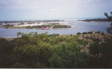
 Lakes Entrance Historical Society
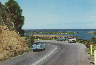
Postcard - Princes Highway Lakes Entrance, AFK International Publishers, 1970 c
Parking bay for viewing the Entrance situated on a sharp bend of the Princes Highway. Also in image part of Bullock Island and New Works area. Three motor cars in picture, post and rail safety fence Lakes Entrance Victoria. Also three colour postcards of same view showing progress at parking bay to steel mesh fence and steel guard rails numbers 04206.1, size 9 x 14 cm, 04206.2, 04206.3 size 10 x 14.5 cmColour postcard showing parking bay for viewing the Entrance situated on a sharp bend of the Princes Highway. Also in image part of Bullock Island and New Works area. Three motor cars in picture, post and rail safety fence Lakes Entrance Victoriacivil engineering, islands, waterways, gippsland lakes, vehicles -
 Ringwood and District Historical Society
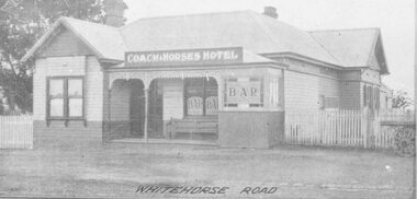
Photograph, Coach and Horses Hotel, Whitehorse Road, Ringwood. 1924
Appears to be reproduction of newspaper photograph. South Side of highway.Written below one photograph, "Photo of Coach and Horses Hotel, corner of White Horse Road and Madden Street. Enter Estate at Madden Street". 1924. -
 Bendigo Historical Society Inc.
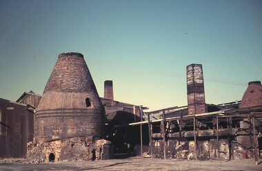
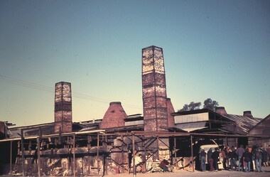
Slide - BENDIGO & EASTER FAIR, 1972
Kilns at the Bendigo Pottery, Midland Highway, Epsom, Bendigo.slide, bendigo, bendigo pottery, kilns bendigo pottery -
 Bendigo Historical Society Inc.
Slide - BENDIGO & EASTER FAIR, 1972
Kilns at the Bendigo Pottery, Midland Highway, Epsom, Bendigo.slide, bendigo, bendigo pottery, kilns at bendigo pottery -
 Bendigo Historical Society Inc.
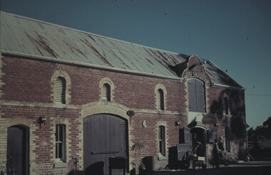
Slide - BENDIGO & EASTER FAIR, 1972
Stable Gallery at Bendigo Pottery, Midland Highway, Epsom.slide, bendigo, bendigo pottery, stable gallery, bendigo pottery -
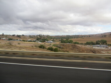
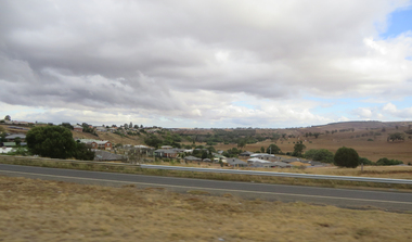 Ballarat Heritage Services
Photographs - Colour, Clare Gervasoni, Bacchus Marsh from the Western Highway, 2019, 31/03/2019
Colour photograph of Bacchus Marsh from the Western Highway. bacchus marsh -
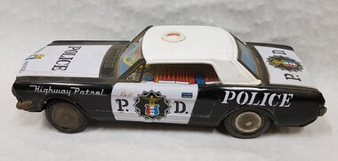 Numurkah & District Historical Society
Tin, toy police car
Black & White Tin Police Car. Rubber wheels. Siren on roof missingP.D. / Police / Highway Patrol toy, children, tin, car, police -
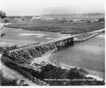 Lakes Entrance Historical Society
Postcard - North Arm bridge Lakes Entrance Victoria, 1920c
Also 2x identical fade P)1151-2,3Black and white miniature postcard of the concrete bridge spanning the North Arm, showing the bridge and abutments,road to bridge from Kalimna, and post and rail fences along road, grass covered mud flats with Club Hotel, Methodist Church and Maranui Guesthouse in distance amongst other buildings. Cunninghame Arm and sand hummocks in far distance. Sandbars visible in North Arm. Lakes Entrance VictoriaPrincess highway Lakes Entrancebridges, coast, religion, hotels, guesthouses -
![Photograph - Construction of the F19 [Eastern Freeway], Ron Setford, January 1977](/media/collectors/550653872162f11fb04854aa/items/683be0ac69688f11138ec21e/item-media/683be0d069688f11138ec49c/item-fit-380x285.jpg) Kew Historical Society Inc
Kew Historical Society IncPhotograph - Construction of the F19 [Eastern Freeway], Ron Setford, January 1977
Ron Setford and his wife Grace Setford lived in Tanner Avenue, East Kew, from c.1946 to c.1995. A keen photographer, he recorded the changing face of Kew over a 20 year period. Apart from 30 photographs of built structures and places in Kew dating from 1960 and 1961, 145 of his 35mm colour slides chronicle the development of the F19 (later renamed Eastern) Freeway through the Yarra Valley in Kew over a five year period from c.1972 to c.1977. This important collection was donated to the Society by his granddaughter in 2025.This collection of 175 35mm slides is of local and statewide significance, owing to its subject matter, particularly the major development of road transport infrastructure during the 1970s with the construction of the Eastern Freeway. The photographer also took care to annotate and date most of his slides which enable the researcher to pinpoint temporal and spatial locations."Freeway / Chandler Highway Bridges"ron setford, eastern freeway, f19 freeway -
![Photograph - Construction of the F19 [Eastern Freeway], Ron Setford, January 1977](/media/collectors/550653872162f11fb04854aa/items/683bdf5d69688f11138eb53e/item-media/683bdf7e69688f11138eb75a/item-fit-380x285.jpg) Kew Historical Society Inc
Kew Historical Society IncPhotograph - Construction of the F19 [Eastern Freeway], Ron Setford, January 1977
Ron Setford and his wife Grace Setford lived in Tanner Avenue, East Kew, from c.1946 to c.1995. A keen photographer, he recorded the changing face of Kew over a 20 year period. Apart from 30 photographs of built structures and places in Kew dating from 1960 and 1961, 145 of his 35mm colour slides chronicle the development of the F19 (later renamed Eastern) Freeway through the Yarra Valley in Kew over a five year period from c.1972 to c.1977. This important collection was donated to the Society by his granddaughter in 2025.This collection of 175 35mm slides is of local and statewide significance, owing to its subject matter, particularly the major development of road transport infrastructure during the 1970s with the construction of the Eastern Freeway. The photographer also took care to annotate and date most of his slides which enable the researcher to pinpoint temporal and spatial locations."Freeway / Chandler Highway Bridge"ron setford, eastern freeway, f19 freeway -
![Photograph - Construction of the F19 [Eastern Freeway], Ron Setford, July 1977](/media/collectors/550653872162f11fb04854aa/items/683bdefd69688f11138eb24b/item-media/683bdf1e69688f11138eb44d/item-fit-380x285.jpg) Kew Historical Society Inc
Kew Historical Society IncPhotograph - Construction of the F19 [Eastern Freeway], Ron Setford, July 1977
Ron Setford and his wife Grace Setford lived in Tanner Avenue, East Kew, from c.1946 to c.1995. A keen photographer, he recorded the changing face of Kew over a 20 year period. Apart from 30 photographs of built structures and places in Kew dating from 1960 and 1961, 145 of his 35mm colour slides chronicle the development of the F19 (later renamed Eastern) Freeway through the Yarra Valley in Kew over a five year period from c.1972 to c.1977. This important collection was donated to the Society by his granddaughter in 2025.This collection of 175 35mm slides is of local and statewide significance, owing to its subject matter, particularly the major development of road transport infrastructure during the 1970s with the construction of the Eastern Freeway. The photographer also took care to annotate and date most of his slides which enable the researcher to pinpoint temporal and spatial locations."Chandler Highway / 7/77"ron setford, eastern freeway, f19 freeway -
Ringwood and District Historical Society
Photographs, 12 coloured photographs of Maroondah Highway and around clock tower. c1990s, C1990s
12 coloured photographs of Maroondah Highway and around clock tower -
Whitehorse Historical Society Inc.
Article, Trams rumble into Vermont South for first time, 2005
Trams rumble into Vermont South for first time.Launch of Burwood Highway tram route extended to Vermont SouthTrams rumble into Vermont South for first time.tram services, burwood highway, vermont south, vermont south -
Whitehorse Historical Society Inc.
Document, Ringwood
Development of the transport facilities from and to Ringwood with Development of Maroondah Highwayringwood, roads and streets, maroondah highway -
 Healesville and District Historical Society
Sign - John Green & Coranderrk, Green Street - Healesville Historic Walk
Information sign at corner of Green Street and Maroondah Highway, Healesville.See image. -
 Lakes Entrance Historical Society
Photograph - Kite Festival, 1/11/1995 12:00:00 AM
Princes Highway viewing Point Kalimna showing Bullock Island during the International Kite Festival. The vast expanse of dumped sand perfect for Kite Flying but not the environment covers a large area of the island Lakes Entrance Victoria. Also a colour photograph taken of banners and kites at the Foorbridge venue of the International Kite Festival number 04048.1Colour photograph taken from Princes Highway viewing Point Kalimna showing Bullock Island during the International Kite Festival. The vast expanse of dumped sand perfect for Kite Flying but not the environment covers a large area of the island Lakes Entrance Victoria. Also 2 colour photographs taken of banners and kites at the Footbridge venue of the International Kite Festival number 04048.1 and 04048.2 sports, kites, events -
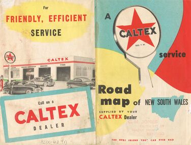 Bendigo Historical Society Inc.
Document - J W SWATTON COLLECTION: MAP OF NEW SOUTH WALES
Two Road maps of New South Wales. C M Jones, Caltex Dealer, Golden Square, Bendigo stamped on the front. Map shows Sydney Outlet Roads, City of Sydney, City of canberra, Newcastle District, Motor tours Around Sydney, Routes to Brisbane, Road Map of New South Wales. It also lists the Principal Towns with Distances from Sydney and Interstate Road Mileages including Sydney to Melbourne via Hume Highway, Prince's Highway, via Canberra & Bombala. Also Sydney to Adelaide via Hume & Sturt Highways, Sydney to Brisbane via New England Highway, Pacific Highway via Toowoomba and Sydney to Adelaide via Western, Mid-Western and Sturt Highways.person, receipts, j w swatton, j w swatton collection, road map of new south wales, caltex, c m jones, e s sculley, clive barrass -
![Photograph - Construction of the F19 [Eastern Freeway], Ron Setford, November 1972](/media/collectors/550653872162f11fb04854aa/items/67fb2de2a8240b7bcaf334be/item-media/67fb2e09a8240b7bcaf3366d/item-fit-380x285.jpg) Kew Historical Society Inc
Kew Historical Society IncPhotograph - Construction of the F19 [Eastern Freeway], Ron Setford, November 1972
Ron Setford and his wife Grace Setford lived in Tanner Avenue, East Kew, from c.1946 to c.1995. A keen photographer, he recorded the changing face of Kew over a 20 year period. Apart from 30 photographs of built structures and places in Kew dating from 1960 and 1961, 145 of his 35mm colour slides chronicle the development of the F19 (later renamed Eastern) Freeway through the Yarra Valley in Kew over a five year period from c.1972 to c.1977. This important collection was donated to the Society by his granddaughter in 2025.This collection of 175 35mm slides is of local and statewide significance, owing to its subject matter, particularly the major development of road transport infrastructure during the 1970s with the construction of the Eastern Freeway. The photographer also took care to annotate and date most of his slides which enable the researcher to pinpoint temporal and spatial locations."Approach to Chandler Highway / Nov 72"ron setford, eastern freeway, f19 freeway -
![Photograph - Construction of the F19 [Eastern Freeway], Ron Setford, May 1976](/media/collectors/550653872162f11fb04854aa/items/6828828d64071e7c58e68949/item-media/682882ac64071e7c58e68b4b/item-fit-380x285.jpg) Kew Historical Society Inc
Kew Historical Society IncPhotograph - Construction of the F19 [Eastern Freeway], Ron Setford, May 1976
Ron Setford and his wife Grace Setford lived in Tanner Avenue, East Kew, from c.1946 to c.1995. A keen photographer, he recorded the changing face of Kew over a 20 year period. Apart from 30 photographs of built structures and places in Kew dating from 1960 and 1961, 145 of his 35mm colour slides chronicle the development of the F19 (later renamed Eastern) Freeway through the Yarra Valley in Kew over a five year period from c.1972 to c.1977. This important collection was donated to the Society by his granddaughter in 2025.This collection of 175 35mm slides is of local and statewide significance, owing to its subject matter, particularly the major development of road transport infrastructure during the 1970s with the construction of the Eastern Freeway. The photographer also took care to annotate and date most of his slides which enable the researcher to pinpoint temporal and spatial locations."Dual highways towards Burke Rd"ron setford, eastern freeway, f19 freeway -
![Photograph - Construction of the F19 [Eastern Freeway], Ron Setford, December 1977](/media/collectors/550653872162f11fb04854aa/items/683bda9d69688f11138e958c/item-media/683bdab769688f11138e9604/item-fit-380x285.jpg) Kew Historical Society Inc
Kew Historical Society IncPhotograph - Construction of the F19 [Eastern Freeway], Ron Setford, December 1977
Ron Setford and his wife Grace Setford lived in Tanner Avenue, East Kew, from c.1946 to c.1995. A keen photographer, he recorded the changing face of Kew over a 20 year period. Apart from 30 photographs of built structures and places in Kew dating from 1960 and 1961, 145 of his 35mm colour slides chronicle the development of the F19 (later renamed Eastern) Freeway through the Yarra Valley in Kew over a five year period from c.1972 to c.1977. This important collection was donated to the Society by his granddaughter in 2025.This collection of 175 35mm slides is of local and statewide significance, owing to its subject matter, particularly the major development of road transport infrastructure during the 1970s with the construction of the Eastern Freeway. The photographer also took care to annotate and date most of his slides which enable the researcher to pinpoint temporal and spatial locations."F19 (F83) Freeway / Chandler Highway"ron setford, eastern freeway, f19 freeway -
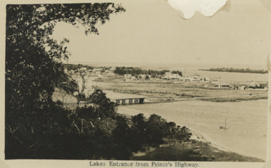 Lakes Entrance Historical Society
Postcard - First concrete bridge over North Arm Lakes Entrance Victoria, H D Bulmer, 1920 c
First concrete bridge over North Arm swamp land behind buildings on Esplanade low sand dunes on outer barrier Lakes Entrance VictoriaBlack and white postcard of township showing first concrete bridge over North Arm swamp land behind buildings on Esplanade low sand dunes on outer barrier Lakes Entrance VictoriaLakes Entrance from Princes Highwayislands, roads and streets, bridges, township -
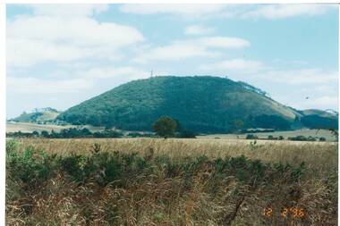 Buninyong & District Historical Society
Photograph - Original Photograph, Ann Beggs-Sunter, Mount Buninyong from Midland Highway at Scotsburn, 1996, November 1995
historic transportColour photo, Mount Buninyong from Midland Highway at Scotsburn, 1996mount buninyong -
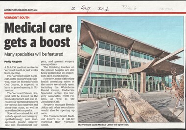 Whitehorse Historical Society Inc.
Article, Medical Care gets a Boost, 2016
The Vermont South Medical Centre on Burwood Highway is expected to open in November.vermont south medical centre, vermont private hospital, burwood highway, vermont south, 645 - 647 -
 Ballarat Heritage Services
Photographs - Colour, Clare Gervasoni, Underbank Development at Bacchus Marsh from the Western Highway, 2019, 31/03/2019
Colour photograph of the Bacchus Marsh suburb of Underbank from the Western Highway. bacchus marsh -
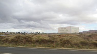
 Ballarat Heritage Services
Photographs - Colour, Clare Gervasoni, Bacchus Marsh from the Western Highway, 2019, 31/03/2019
Colour photograph of the Bacchus Marsh suburb of Underbank from the Western Highway. bacchus marsh