Showing 155 items
matching igneous-volcanic
-
 Ringwood and District Historical Society
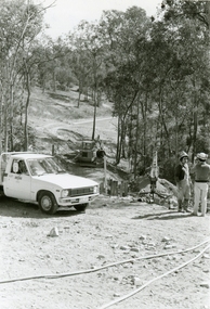
Photographs, 1979-80 MMBW pipe line project at Hubbard Reserve, North Ringwood � Air track drill rig
Part of a 43-photo record of the MMBW�s engineering feat in drilling a 12 inch pipe line up to 40 feet deep through rock hardened by volcanic action associated with geological fault that occurs along the line. The work took place from October 1979 to May 1980 on the southern boundary of Hubbard Reserve, North Ringwood. The collection was presented to the Ringwood Historical Research Group by J Clarke on 9th June 1980.E561 N19 3 March 1980 A43 Air track drill rig in position as in N18 -
 Ringwood and District Historical Society
Photographs, 1979-80 MMBW pipe line project at Hubbard Reserve, North Ringwood � Last days of the boring
Part of a 43-photo record of the MMBW�s engineering feat in drilling a 12 inch pipe line up to 40 feet deep through rock hardened by volcanic action associated with geological fault that occurs along the line. The work took place from October 1979 to May 1980 on the southern boundary of Hubbard Reserve, North Ringwood. The collection was presented to the Ringwood Historical Research Group by J Clarke on 9th June 1980.E561 N1 1 April 1980 A43 Last days of the boring. The mole had broken between the last two shafts. Dominic Di Nezza and Glen Pearson discuss further moves to release it. -
 Ringwood and District Historical Society
Photographs, 1979-80 MMBW pipe line project at Hubbard Reserve, North Ringwood � Drill rig
Part of a 43-photo record of the MMBW�s engineering feat in drilling a 12 inch pipe line up to 40 feet deep through rock hardened by volcanic action associated with geological fault that occurs along the line. The work took place from October 1979 to May 1980 on the southern boundary of Hubbard Reserve, North Ringwood. The collection was presented to the Ringwood Historical Research Group by J Clarke on 9th June 1980.E561 N17 3 March 1980 A43 Powder-monkey marks out the spots for holes -
 Ringwood and District Historical Society
Photographs, 1979-80 MMBW pipe line project at Hubbard Reserve, North Ringwood � View towards Debbie Place
Part of a 43-photo record of the MMBW�s engineering feat in drilling a 12 inch pipe line up to 40 feet deep through rock hardened by volcanic action associated with geological fault that occurs along the line. The work took place from October 1979 to May 1980 on the southern boundary of Hubbard Reserve, North Ringwood. The collection was presented to the Ringwood Historical Research Group by J Clarke on 9th June 1980.E561 N15 3 March 1980 A43 View towards Debbie Place, showing 2 swivel cranes at shafts, timber of manhole in creek, the tracked drill rig and its compressor caravan. -
 Ringwood and District Historical Society
Photographs, 1979-80 MMBW pipe line project at Hubbard Reserve, North Ringwood � Boring mole pit
Part of a 43-photo record of the MMBW�s engineering feat in drilling a 12 inch pipe line up to 40 feet deep through rock hardened by volcanic action associated with geological fault that occurs along the line. The work took place from October 1979 to May 1980 on the southern boundary of Hubbard Reserve, North Ringwood. The collection was presented to the Ringwood Historical Research Group by J Clarke on 9th June 1980.E561 N14 3 March 1980 A43 View west behind No. 29 Burlock Avenue, showing gantry over manhole 38 feet deep. -
 Ringwood and District Historical Society
Photographs, 1979-80 MMBW pipe line project at Hubbard Reserve, North Ringwood � The work on sewer line from 29-39 Burlock Avenue
Part of a 43-photo record of the MMBW�s engineering feat in drilling a 12 inch pipe line up to 40 feet deep through rock hardened by volcanic action associated with geological fault that occurs along the line. The work took place from October 1979 to May 1980 on the southern boundary of Hubbard Reserve, North Ringwood. The collection was presented to the Ringwood Historical Research Group by J Clarke on 9th June 1980.E561 N11 3 March 1980 A43 The work on sewer line from 29-39 Burlock Avenue. Lundy-Clarke's place on sky-line. -
 Ringwood and District Historical Society
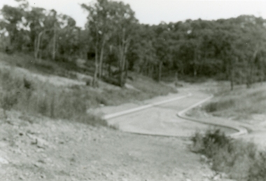
Photograph, 1979-80 MMBW pipe line project at Hubbard Reserve, North Ringwood. Debbie Place from the east end
Part of a 43-photo record of the MMBW's engineering feat in drilling a 12 inch pipe line up to 40 feet deep through rock hardened by volcanic action associated with geological fault that occurs along the line. The work took place from October 1979 to May 1980 on the southern boundary of Hubbard Reserve, North Ringwood. The collection was presented to the Ringwood Historical Research Group by J Clarke on 9th June 1980.E550 N12 Dec 1979 A43 Debbie Place from the east end -
 Ringwood and District Historical Society
Photographs, 1979-80 MMBW pipe line project at Hubbard Reserve, North Ringwood � View from Debbie Place, preliminary sewer work
Part of a 43-photo record of the MMBW�s engineering feat in drilling a 12 inch pipe line up to 40 feet deep through rock hardened by volcanic action associated with geological fault that occurs along the line. The work took place from October 1979 to May 1980 on the southern boundary of Hubbard Reserve, North Ringwood. The collection was presented to the Ringwood Historical Research Group by J Clarke on 9th June 1980.E561 N13 28 Feb 1980 A43 View from Debbie Place, preliminary sewer work -
 Ringwood and District Historical Society
Photographs, 1979-80 MMBW pipe line project at Hubbard Reserve, North Ringwood � Line of tunnel shafts behind 29-39 Burlock Avenue
Part of a 43-photo record of the MMBW�s engineering feat in drilling a 12 inch pipe line up to 40 feet deep through rock hardened by volcanic action associated with geological fault that occurs along the line. The work took place from October 1979 to May 1980 on the southern boundary of Hubbard Reserve, North Ringwood. The collection was presented to the Ringwood Historical Research Group by J Clarke on 9th June 1980.E561 N10 Feb 1980 A43 Line of tunnel shafts behind 29-39 Burlock Avenue. Horizontal gantry was above the manhole in the corner of No. 29. -
 Ringwood and District Historical Society
Photographs, 1979-80 MMBW pipe line project at Hubbard Reserve, North Ringwood � First hole west of bore hole at 39 Burlock Avenue
Part of a 43-photo record of the MMBW�s engineering feat in drilling a 12 inch pipe line up to 40 feet deep through rock hardened by volcanic action associated with geological fault that occurs along the line. The work took place from October 1979 to May 1980 on the southern boundary of Hubbard Reserve, North Ringwood. The collection was presented to the Ringwood Historical Research Group by J Clarke on 9th June 1980.E561 N9 Feb 1980 A43 First hole west of bore hole at 39 Burlock Avenue -
 The Beechworth Burke Museum
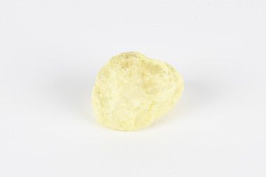
Geological specimen - Native Sulphur, unknown
Native Sulphur in its solid form is a yellow crystalline mineral that forms near volcanic vents and fumaroles where it is the solid form of hot gases. It is also frequently found in the subsurface as a by-product of sulphide ore mineralization. In all its forms, sulphur is one of the most commonly occurring minerals on the planet, especially in natural gases, and is key to the make-up of a range of other minerals. It is essential to continuing life on earth, and was used in ancient societies as part of medical care, religious rites, and entertainment, and was key to the invention of gunpowder by the Chinese. Native Sulphur in its solid form is a yellow crystalline mineral that forms near volcanic vents and fumaroles where it is the solid form of hot gases. It is also frequently found in the subsurface as a by-product of sulphide ore mineralization. In all its forms, sulphur is one of the most commonly occurring minerals on the planet, especially in natural gases, and is key to the make-up of a range of other minerals. It is essential to continuing life on earth and was used in ancient societies as part of medical care, religious rites, and entertainment, and was key to the invention of gunpowder by the Chinese. The exact site of extraction for this specimen is unknown, but it was probably collected in New Zealand in the 1850s. Sulphur is significant both for its historical and current uses, and for its nature as one of the most abundant minerals on the planet. Sulphur's importance comes both from its abundance and its role in ensuring survival, creating other minerals, and daily human life. This specimen is significant as representative of sulphur's solid properties. This specimen is part of a larger collection of geological and mineral specimens collected from around Australia (and some parts of the world) and donated to the Burke Museum between 1868-1880. A large percentage of these specimens were collected in Victoria as part of the Geological Survey of Victoria that begun in 1852 (in response to the Gold Rush) to study and map the geology of Victoria. Collecting geological specimens was an important part of mapping and understanding the scientific makeup of the earth. Many of these specimens were sent to research and collecting organisations across Australia, including the Burke Museum, to educate and encourage further study.A solid, small, crystalline mineral specimen that is largely bright yellow, with some darker spotting. geological specimen, geology, geology collection, burke museum, beechworth, sulphur, native sulphur, new zealand, native sulphur specimen, sulphur specimen -
 The Beechworth Burke Museum
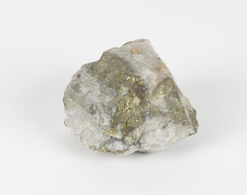
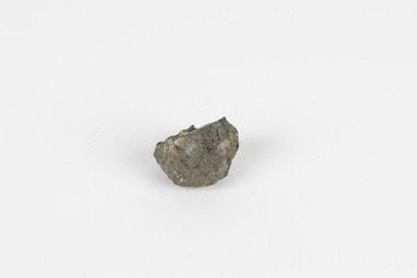
Geological specimen - Pyrite
This specimen was recovered from Adelong, NSW. The initial discovery of gold at Adelong by a Mr Williams took place in 1857. Much of the area is underlain by granitic rocks, while at Adelong itself a prominent norite intrusive body occurs. To the west of Adelong is a belt of intermediate to mafic igneous rocks and sediments which extends from Batlow in the south to at least as far north as the Snowy Mountains Highway. Around 26 tonnes of gold was found at the Adelong goldfield from its discovery in the 1850s until the last miners left in the 1940s. Pyrite has the formula of FeS2 and forms as an isometric (cube) form. It is a common occurring material and is often mistaken for gold, now colloquially known as ‘fool’s gold’. Pyrite that has strongly crystallised is considered stable, but the mineral has the potential to oxidise and decay. This specimen is part of a larger collection of geological and mineral specimens collected from around Australia (and some parts of the world) and donated to the Burke Museum between 1868-1880. A large percentage of these specimens were collected in Victoria as part of the Geological Survey of Victoria that begun in 1852 (in response to the Gold Rush) to study and map the geology of Victoria. Collecting geological specimens was an important part of mapping and understanding the scientific makeup of the earth. Many of these specimens were sent to research and collecting organisations across Australia, including the Burke Museum, to educate and encourage further study.Pyrite is iron sulphide (also known as “fool's gold”) which is commonly found in slates.Existing Label: 104 /burke museum, beechworth, indigo shire, beechworth museum, geological, geological specimen, mineralogy, pyrite, adelong -
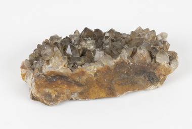 The Beechworth Burke Museum
Geological specimen - Smoky quartz crystals, unknown
Quartz is an extremely common mineral to find across the world. Quartz can have two forms; Microcrystalline quartz or Crystalline quartz. Microcrystalline quartz is a fine grain quartz where crystalline quartz is often a large crystal. This specimen is a crystalline quartz. Made of silicon oxide, this specimen is called smokey quartz crystals because of its brownish colour. However, the colour of quartz can vary. In addition, quartz are formed in deep-seated igneous rocks and crystallized through hot aqueous solutions. This type of crystal can be found all over Australia, including Beechworth in Victoria. Other places quartz can be found is the Ashburton River area in Western Australia, Marlborough in Queensland, the Lune River area in Tasmania and Kingsgate in New South Wales. This specimen is significant because it is common to find this kind of mineral. While the location of where this specimen was originally from is unknown, it highlights the many places in Australia where quartz is found. It demonstrates that quartz makes up a large portion of Australia's geology. In addition, quartz itself can vary in its colour and shape. This specimen represents one of these variations. That being smoky quartz crystals. This specimen is part of a larger collection of geological and mineral specimens collected from around Australia (and some parts of the world) and donated to the Burke Museum between 1868-1880. A large percentage of these specimens were collected in Victoria as part of the Geological Survey of Victoria that begun in 1852 (in response to the Gold Rush) to study and map the geology of Victoria. Collecting geological specimens was an important part of mapping and understanding the scientific makeup of the earth. Many of these specimens were sent to research and collecting organisations across Australia, including the Burke Museum, to educate and encourage further study.A large hand-sized quartz mineral with shades of brown and gray throughout.Smoky quartz / crystals /locality/ unknown / (needs a wash) /BBgeological specimen, geology, geology collection, burke museum, beechworth, microcrystalline, quartz, quartz mining, quartz reefs beechworth, smokey quartz crystals, crystals, crystalline, silicon oxide, brown, colour, igneous rocks, magma, ashburton river, western australia, marlborough, queensland, lune river, tasmania, kingsgate, new south wales, nsw -
 Ringwood and District Historical Society
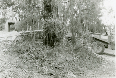
Photographs, 1979-80 MMBW pipe line project at Hubbard Reserve, North Ringwood � Back-hoe at pit
E560 N6 Dec 1979 A43 The back-hoe works on the beginnings of pit in 39 Burlock Avenue backyard Part of a 43-photo record of the MMBW�s engineering feat in drilling a 12 inch pipe line up to 40 feet deep through rock hardened by volcanic action associated with geological fault that occurs along the line. The work took place from October 1979 to May 1980 on the southern boundary of Hubbard Reserve, North Ringwood. The collection was presented to the Ringwood Historical Research Group by J Clarke on 9th June 1980. -
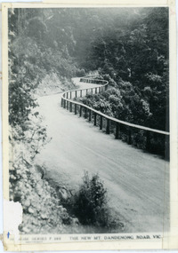 Mt Dandenong & District Historical Society Inc.
Photograph, The New Mt Dandenong Road, Vic
Copy of Rose Series postcard #385 showing the new Mt Dandenong Tourist Road with wooden railing fence on low side of road. Surface not yet made. This photograph has a detailed inscription on the back handwritten by John Lundy-Clarke in 1974.View downhill from the Windy Bend showing the site of the 1972 landslide. In this picture the road is running along the top edge of the wall 900’ thick of Kalorama Docite that plunges thousands of feet deep down into the earth below the Ranges and extends to Fern Tree Gully. It was once a horizontal terrace nearly ten miles square and tipped over to the left when the mountain subsided into its volcanic cauldron.mt dandenong road, rose series, windy bend, landslide -
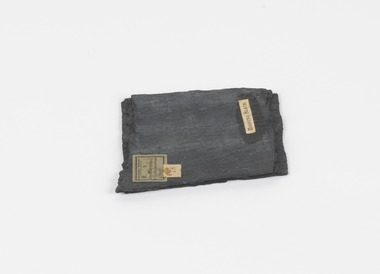 The Beechworth Burke Museum
Geological specimen - Slate (Metamorphic), Unknown
This particular specimen was found in the Moorabool Slate quarries in Victoria. The Moorabool Slate quarries was established in the 1860’s by a company of Welshmen with a crew of six who purchased land by the riverside to mine for slate. Under the promise of adding to existing recourses the crew mined the slate which was used for paving and roofing. Slate is a fine-grained, low-grade metamorphic rock that is formed by the transformation of mudstone, shale or sometimes volcanic ash under low pressure and temperatures. It dark colour is due to carbonaceous material or to finely divided iron sulphide. It is believed that Evan Rowlands and Theophilus Williams of Ballarat were the first to discover the slate veins. Slate is a one of the most common natural stones in general use. Being used as paving, flooring, roofing and more. However, its history of being mined in Australia is not common as it is considered that the best places to mine slate is Spain and parts of the United Kingdom. This specimen is part of a larger collection of geological and mineral specimens collected from around Australia (and some parts of the world) and donated to the Burke Museum between 1868-1880. A large percentage of these specimens were collected in Victoria as part of the Geological Survey of Victoria that begun in 1852 (in response to the Gold Rush) to study and map the geology of Victoria. Collecting geological specimens was an important part of mapping and understanding the scientific makeup of the earth. Many of these specimens were sent to research and collecting organisations across Australia, including the Burke Museum, to educate and encourage further study.A somewhat rectangular foliated metamorphic rock composed of quartz, sericite and minerals from the chlorite group that make up the compounds of slate. The rock is dark grey almost black.Geological survey / R S / Loc Moorabool /Slate quarries / 1/4 sheet | 78 | Roofing Slate /burke museum, beechworth, geological, slate, metamorphic, slate (metamorphic), geological specimen, slate specimen, indigo shire -
![Interior of the crater at Mount Franklin / [by] Nicholas Caire, circa 1876](/media/collectors/550653872162f11fb04854aa/items/577b5e58d0cdd10948d30390/item-media/577b5ec3d0cdd10948d34bee/item-fit-380x285.jpg) Kew Historical Society Inc
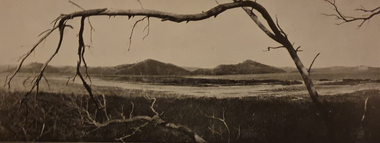
Kew Historical Society IncPhotograph, Anglo-Australasian Photographic Company, Interior of the crater at Mount Franklin, c. 1876
Nicholas Caire was born on Guernsey in the Channel Islands in 1837. He arrived in Adelaide with his parents in about 1860. In 1867, following photographic journeys in Gippsland, he opened a studio in Adelaide. From 1870 to 1876 he lived and worked in Talbot in Central Victoria. In 1876 he purchased T. F. Chuck's studios in the Royal Arcade Melbourne. In 1885, following the introduction of dry plate photography, he began a series of landscape series, which were commercially successful. As a photographer, he travelled extensively through Victoria, photographing places few of his contemporaries had previously seen. He died in 1918. Reference: Jack Cato, 'Caire, Nicholas John (1837–1918)', Australian Dictionary of Biography.An original, rare photograph from the series 'Views of Victoria: General Series' by the photographer, Nicholas Caire (1837-1918). The series of 60 photographs that comprise the series was issued c. 1876 and reinforced a neo-Romantic view of the Australian landscape to which a growing nationalist movement would respond. Nicholas Caire was active as a photographer in Australia from 1858 until his death in 1918. His vision of the Australian bush and pioneer life had a counterpart in the works of Henry Lawson and other nationalist poets, authors and painters.Views of Victoria (General Series) No.33 / ‘Interior of the crater at Mount Franklin’ / Albumen silver photograph mounted on cardOn Reverse: ‘Mount Franklin is situated near Malmsbury, about ten or twelve miles distant. The most remarkable and interesting part of this Mountain is its Crater, which, from its immense size and great depth, denotes that a volcanic eruption of considerable magnitude must have taken place at some period in the past. Looking down from the summit, the large gum trees growing at the bottom of the Crater appear but small saplings.’nicholas caire (1837-1918), mount franklin, victoria - landscape photography -
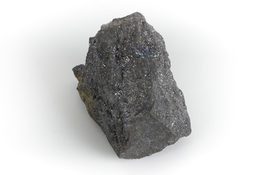 The Beechworth Burke Museum
Geological specimen - Galena Chalcopyrite, Unknown
Galena Chalcopyrite is the earth's primary ore of lead and is mined from a large number of deposits in many countries. It is also an important source of silver. Galena Chalcopyrite is one of the most abundant and widely distributed sulfide minerals across the world. The mineral is found in igneous and metamorphic rocks in medium- to low-temperature hydrothermal veins. This specific specimen was recovered from the mines in Broken Hill, New South Wales. The mines in Broken Hill were first established after Charles Rasp discovered a large amount of silver-lead-zinc ore-body in the area in 1883. BHP (Broken Hill Proprietary) mining company was then established in 1885 and quickly became the lead in Australia's mining industry after they began excavating and exporting the country's largest amount of lead, silver, and zinc. This feat generated over $100 billion in wealth for the company.Galena Chalcopyrite is signifiant as it represents the catalyst for the rise of Australia's most influential mining companies - BHP. The mineral was one of the first to be mined in the country and after being made into lead, was used for a variety of things such as paint, batteries, ammunition, and plumbing materials before it was known to be harmful to humans. This specimen is part of a larger collection of geological and mineral specimens collected from around Australia (and some parts of the world) and donated to the Burke Museum between 1868-1880. A large percentage of these specimens were collected in Victoria as part of the Geological Survey of Victoria that begun in 1852 (in response to the Gold Rush) to study and map the geology of Victoria. Collecting geological specimens was an important part of mapping and understanding the scientific makeup of the earth. Many of these specimens were sent to research and collecting organisations across Australia, including the Burke Museum, to educate and encourage further study. A grey, solid hand-sized lead sulfide mineral with a silver metallic luster.burke museum, beechworth, geological, geological specimen, galena, galena chalcopyrite, chalcopyrite, broken hill, bhp, bhp mining, broken hill mine, mine, australia mine, lead, lead mine -
 The Beechworth Burke Museum
Geological specimen - Olivine with Chromian diopside (dark green), Unknown
This specimen was donated in 1868 by Alfred Selwyn. Olivine is typically found in basic and ultra-basic igneous rocks around the world, in a variety of colours including yellowish green, olive green, greenish black and reddish brown with a transparent to translucent diaphaneity. The luster of the specimen is vitreous, the luminescence non-fluorescent and when fractured the mineral is very brittle producing small, conchoidal fragments. Chromian diopside is normally found in small sizes as the larger the size of the mineral the darker the colour is, almost black rather than green. Chromium is the element that gives chromian diopside and emeralds their rich green colour. Diopside is found across the world in multiple colours however gem-quality chromian diopside is mined in Siberia, Russia and prominent within the jewellery industry as a more affordable substitute to emeralds. Chromium-bearing diopside has been located across Australia. Chromium-bearing Diopside is located across the world found in North America, parts of South America, and across Australia, Africa, Europe and Asia. Chromium-bearing Diopside is mined in Siberia, Russia and is sold as a commercial substitute for emeralds. The stone is often turned into jewellery. This item is one of many geological and mineral specimens that constitute a broader collection obtained from various regions across Australia (as well as some international locales) and generously contributed to the Burke Museum between 1868 and 1880. A significant portion of these specimens originated from Victoria and were acquired as a result of the Geological Survey of Victoria, initiated in 1852 during the Gold Rush era. The primary objective of this survey was to investigate and chart the geological characteristics of Victoria. The procurement of geological specimens played a vital role in advancing our comprehension of the Earth's scientific composition and was instrumental in supporting research and educational institutions throughout Australia, including the Burke Museum, in their efforts to foster further exploration and study. A solid mineral specimen in shades of green, grey and brownburke museum, beechworth, geological, geological specimen -
 Ringwood and District Historical Society
Photographs, 1979-80 MMBW pipe line project at Hubbard Reserve, North Ringwood � Boring mole pit
E560 N5 Dec 1979 A43 Boring mole pit near big box tree in 39 Burlock Avenue backyard Part of a 43-photo record of the MMBW�s engineering feat in drilling a 12 inch pipe line up to 40 feet deep through rock hardened by volcanic action associated with geological fault that occurs along the line. The work took place from October 1979 to May 1980 on the southern boundary of Hubbard Reserve, North Ringwood. The collection was presented to the Ringwood Historical Research Group by J Clarke on 9th June 1980. -
 Ringwood and District Historical Society
Photographs, 1979-80 MMBW pipe line project at Hubbard Reserve, North Ringwood � Cover of mole pit
E560 N24 Jan 1980 A43 Cover of mole pit near big box tree in 39 Burlock Avenue backyard Part of a 43-photo record of the MMBW�s engineering feat in drilling a 12 inch pipe line up to 40 feet deep through rock hardened by volcanic action associated with geological fault that occurs along the line. The work took place from October 1979 to May 1980 on the southern boundary of Hubbard Reserve, North Ringwood. The collection was presented to the Ringwood Historical Research Group by J Clarke on 9th June 1980. -
 Federation University Historical Collection
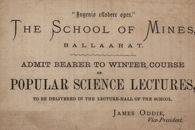
Advertising card, School of Mines: Popular Science Lectures, 1882, 1882
The card enabled a person to attend the 'Popular Science Lectures' which were held in the lecture hall of the school. These were the Winter course of 1882. The Lectures were from 8p.m. They ran from June 9 through to October 11. The subjects were varied and a guest speaker was responsible for each session. G Foord (Royal Mint) - Alchemy; Rev Ick (Sandhurst) - The Wonders of Coral Life; R Ellery (Government Astronomer) - The Sun's Distances and the Transits of Venus; J Thomas (Geelong) - The Stellar Universe; J Usher (Doctor) - Physiology, Body and Bones; Baron Von Mueller (Government Botanist) - General observations on the Flora of Australia; Professor Mica Smith - Gold; Professor F Kraush - Volcanic rocks of the Ballarat District. This was organised by the School Councilwhen James Oddie was Vice-President.Beige coloured card written on both sidespopular science lectures, winter course 1882, guest speakers, g foord, royal mint, alchemy, reverend ick, sandhurst, coral life, r ellery, government astronomer, sun's distances, transits of venus, j thomas, stellar universe, baron von mueller, flora of australia, government botanist, mica smith, gold, f m kraush, volcanic rocks -
 Ballarat Heritage Services
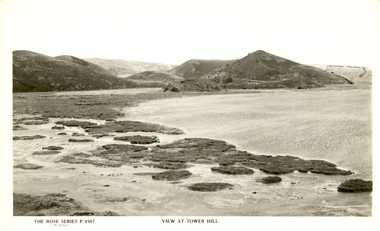
Photograph - Image, Tower Hill, Victoria, c1918, c1918
Tower Hill is a volcanic formation believed to have erupted about 32,000 years ago. Its formation is known as a "nested maar" and it is the largest example of its type in Victoria. During formation, molten lava pushed its way up through the Earth’s crust and encountered a layer of water-bearing rock. Violent explosions followed creating a shallow crater which later filled with water to form the lake. Further eruptions occurred in the centre of this crater, creating the islands and cone shaped hills. In 1892 Tower Hill became Victoria’s first National Park. In 1961, Tower Hill became a State Game Reserve under the then Fisheries and Wildlife Department and a major re-vegetation program began. (https://www.towerhill.org.au/index.php/about-reserve/history, accessed 23 December 2019)Black and white image of Tower Hill, near Koroit, Victoria.tower hill, volcano, crater -
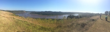 Ballarat Heritage Services
Photograph - Colour photograph, Tower Hill, 2016, 23/12/2015
Tower Hill is a volcanic formation believed to have erupted about 32,000 years ago. Its formation is known as a "nested maar" and it is the largest example of its type in Victoria. During formation, molten lava pushed its way up through the Earth’s crust and encountered a layer of water-bearing rock. Violent explosions followed creating a shallow crater which later filled with water to form the lake. Further eruptions occurred in the centre of this crater, creating the islands and cone shaped hills. In 1892 Tower Hill became Victoria’s first National Park. In 1961, Tower Hill became a State Game Reserve under the then Fisheries and Wildlife Department and a major re-vegetation program began. (https://www.towerhill.org.au/index.php/about-reserve/history, accessed 23 December 2019)Panaramic view of Tower Hill, Victoria.tower hill, volcano, crater -
 Ballarat Heritage Services
Photograph - Photograph - Black and White, Tower Hill, Victoria
Tower Hill is a volcanic formation believed to have erupted about 32,000 years ago. Its formation is known as a "nested maar" and it is the largest example of its type in Victoria. During formation, molten lava pushed its way up through the Earth’s crust and encountered a layer of water-bearing rock. Violent explosions followed creating a shallow crater which later filled with water to form the lake. Further eruptions occurred in the centre of this crater, creating the islands and cone shaped hills. In 1892 Tower Hill became Victoria’s first National Park. In 1961, Tower Hill became a State Game Reserve under the then Fisheries and Wildlife Department and a major re-vegetation program began. (https://www.towerhill.org.au/index.php/about-reserve/history, accessed 23 December 2019)Black and white photograph of Tower Hill devoid of trees.tower hill, crossley, volcano -
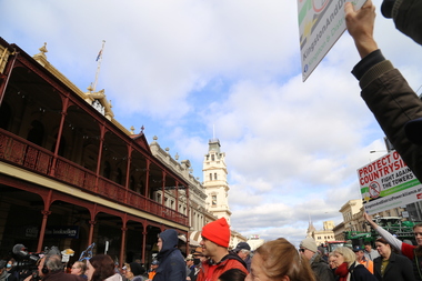
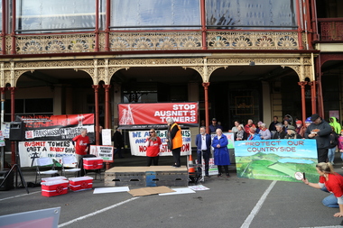
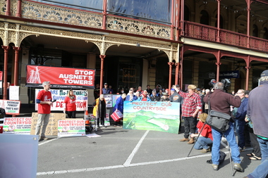
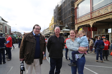 Victorian Farmers Federation
Photograph - Digital Photograph, Stop Ausnet Rally Ballarat - Katherine Myers, Scott Young, Charles Everist, 15 July 2022
VFF is seeking an appropriate framework to ensure farmers do not bear the cost of infrastructure on their farms. Overhead powerlines are proposed through the rich volcanic soils around Ballarat. This land supports 1200 jobs in processing in Ballarat. The towers would impact on the ability to irrigate crops, to use tractors around them, on biosecurity and on ability to use emergency equipment near them. VFF wants assurances that the managing entry to farm policy position will be adhered to and that a statewide strategic plan for renewable energy is prepared. https://www.vff.org.au/wp-content/uploads/2021/09/PS210901LG-Managing-Entry-to-Farms-adopted.pdf https://www.vff.org.au/wp-content/uploads/2021/09/VFF-Renewable-Energy-and-Energy-Efficiency-Policy-Statement-Meeting-172-June-2021.pdfadvocacy, renewable energy, farmers, protest, rally, managing entry to farm, victorian farmers federation, ballarat -
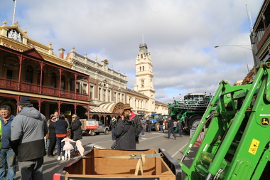 Victorian Farmers Federation
Photograph - Digital Photograph, Stop Ausnet Rally Ballarat - post event scenes, 15 July 2022
VFF is seeking an appropriate framework to ensure farmers do not bear the cost of infrastructure on their farms. Overhead powerlines are proposed through the rich volcanic soils around Ballarat. This land supports 1200 jobs in processing in Ballarat. The towers would impact on the ability to irrigate crops, to use tractors around them, on biosecurity and on ability to use emergency equipment near them. VFF wants assurances that the managing entry to farm policy position will be adhered to and that a statewide strategic plan for renewable energy is prepared. https://www.vff.org.au/wp-content/uploads/2021/09/PS210901LG-Managing-Entry-to-Farms-adopted.pdf https://www.vff.org.au/wp-content/uploads/2021/09/VFF-Renewable-Energy-and-Energy-Efficiency-Policy-Statement-Meeting-172-June-2021.pdfadvocacy, renewable energy, farmers, protest, rally, managing entry to farm, victorian farmers federation, ballarat -
 Victorian Farmers Federation
Photograph - Digital Photograph, Stop Ausnet Rally Ballarat, 15 July 2022
VFF is seeking an appropriate framework to ensure farmers do not bear the cost of infrastructure on their farms. Overhead powerlines are proposed through the rich volcanic soils around Ballarat. This land supports 1200 jobs in processing in Ballarat. The towers would impact on the ability to irrigate crops, to use tractors around them, on biosecurity and on ability to use emergency equipment near them. VFF wants assurances that the managing entry to farm policy position will be adhered to and that a statewide strategic plan for renewable energy is prepared. https://www.vff.org.au/wp-content/uploads/2021/09/PS210901LG-Managing-Entry-to-Farms-adopted.pdf https://www.vff.org.au/wp-content/uploads/2021/09/VFF-Renewable-Energy-and-Energy-Efficiency-Policy-Statement-Meeting-172-June-2021.pdfadvocacy, renewable energy, farmers, protest, rally, managing entry to farm, victorian farmers federation, ballarat