Showing 169 items matching "jemmys point lakes entrance"
-
 Lakes Entrance Historical Society
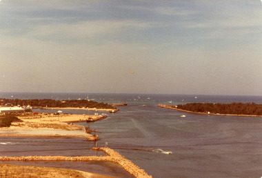
Photograph - The Entrance, Holding George, 1979
Date made April 1979Colour photograph of the Entrance, Bullock Island and Reeves Channel, taken from Jemmys Point during the King of the Straits, offshore powerboat race. It also shows the built up groynes at the entrance to the North Arm, Pecks fish processing factory seen on Bullock Island. Lakes Entrance Victoriawaterways, recreation, boats and boating -
 Lakes Entrance Historical Society
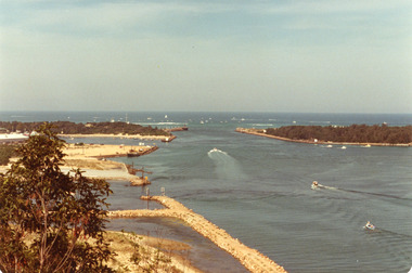
Photograph - The Entrance, 1979
The king of the straits, offshore powerboat race with Lakes entrance as a destination was not repeated due to adverse weather conditionsColour photograph of the entrance, Bullock Island and Reeves Channel. Taken from Jemmys Point during the King of the Strait offshore powerboat race. It also shows the built up groynes at the entrance to the North Arm. Lakes Entrance Victoriafishing industry, waterways, boats and boating -
 Lakes Entrance Historical Society
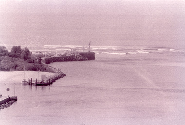
Photograph - The Entrance, Fish Marie, 1995
Black and white photograph of the Eastern Pier, taken from Jemmys Point. It shows the rock wall of the pier, rock groynes at the entrance to Cunninghame Arm behind which dredged sand has been dumped. Lakes Entrance Victoria waterways, piers -
 Lakes Entrance Historical Society
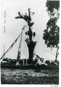
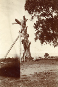
Photograph - Lookout tree, Bulmer H D, 1910 c
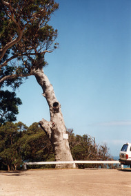
Also copy 15 x 10 same imageBlack and white photograph copied from a postcard of the LookOut Tree on Jemmys Point, shows the standing dead grey box tree supported by two heavy logs, a 35 foot ladder attached for access to top. Lakes Entrance Victoria.historic sites, navigation -
 Lakes Entrance Historical Society
Photograph - Lookout tree, 1910
Black and white small format photograph of the LookOut Tree at Jemmys Point, showing dead tree supported by two logs, a woman two-thirds of the way up the 35 foot ladder which reaches the top. Lakes Entrance, Victoriahistoric sites, navigation -
 Lakes Entrance Historical Society
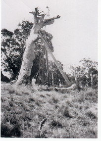
Photograph - Lookout tree, 1927
Black and white photograph of the Lookout Tree on Jemmys Point showing a standing dead grey box tree supported by two long timbers. Access to the top via a 35 foot ladder. Thelma Roder standing on top beside signal structure, two women and child standing near base. Lakes Entrance Victoria,historic sites, navigation -
 Lakes Entrance Historical Society
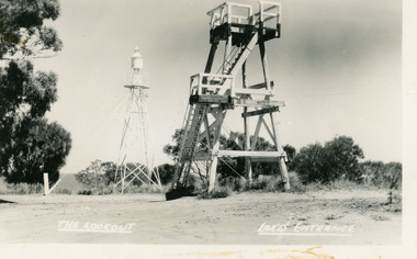
Postcard - Lookout tower Jemmy's Point, Bulmer H D, 1950
Black and white postcard of the timber lookout on Jemmys Point, with the signal light on steel tower nearby. Lakes Entrance Victoria,The Lookout, Lakes Entrancehistoric sites, navigation -
 Lakes Entrance Historical Society
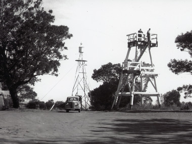
Photograph - Lookout tower Jemmy's Point, 1960
Also one other photograh similar showing steps, landing, and Carpenters Chev car parked.Black and white photograph of the timber lookout on Jemmys Point, steel tower with signal light in background, base of old lookout tree visible on left of image. Lakes Entrance, Victoria.historic sites, navigation -
 Lakes Entrance Historical Society
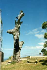
Photograph - Lookout tree, 1990
Colour photograph of the old lookout tree on Jemmys Point, showing a standing dead grey box tree, remains of three branches at top which once held a platform and signal structure. Two timber seats on lawn at base, roadway in foreground. Lakes Entrance, Victoria,2008historic sites, navigation -
 Lakes Entrance Historical Society
Photograph - Lookout tree, 1990
Colour photograph of the old lookout tree on Jemmys Point, showing a standing dead grey box tree, remains of three branches at top which once held a platform and signal structure. Two timber seats on lawn at base, roadway in foreground. Lakes Entrance, Victoria,historic sites, navigation -
 Lakes Entrance Historical Society
Postcard - Reeve's Channel, Valentine Series, 1940
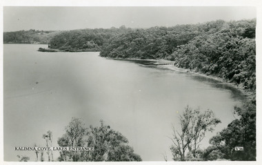
Black and white postcard taken from elevation on Jemmys Point, showing Reeves Channel, Gippsland Lakes, including Kalimna Jetty and Sawmill Flat at entrance to Maringa Creek, timbered cliffs above lake. Lakes Entrance VictoriaKalimna at Lakes Entrance boats and boating, waterways, topography -
 Lakes Entrance Historical Society
Postcard - Township, 1935c
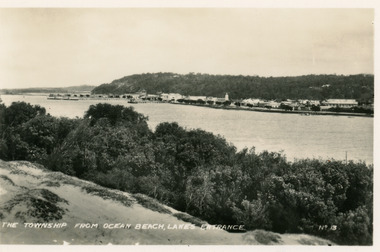
Black and white small format postcard of town, taken from south shore of the lake. It shows a panoramic view of Esplanade and buildings, jetties, Great War Memorial cypress trees, Jemmys Point and Kalimna Heights in background. Vegetation of sand hummocks in foreground. Lakes Entrance VictoriaThe Township from Ocean Beach Lakes Entrance No 13memorials, vegetation, waterfront, township -
 Lakes Entrance Historical Society
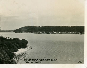
Postcard - Township, 1930c
Black and white small format postcard of the town, taken from the south shore of the lake. It shows a distant view of the town with Jemmys Point and Kalimna Heights in the background, portion of vegetation and south shore beside lake in foreground. Lakes Entrance VictoriaThe Township from Ocean Beach, Lakes Entrance V25vegetation, township, waterfront -
 Lakes Entrance Historical Society
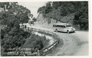
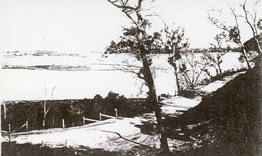
Postcard - Transport, Bulmer H D, 1960c
1 other copyBlack and white postcard of a bend in the Princes Highway at Jemmys Point. It shows two tourist coaches on the road between the steep road cutting and the post and rail fence, gravel footpath on road side of fence. Man directing traffic. Lakes Entrance VictoriaTourist coaches at Lakes Entrance, Victourism, transport, roads and streets -
 Lakes Entrance Historical Society
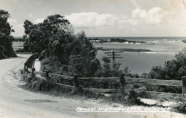
Postcard, Bulmer H D, 1920c
Black and white copy same sizeTinted postcard of a bend in the Princes Highway, Jemmys Point. It shows the road between the steep cutting and post and rail fence. Glimpse of footbridge to Bullock Island, entrance and hummocks. Lakes Entrance VictoriaPrinces Highway, Lakes Entrance topography, waterways, roads and streets -
 Lakes Entrance Historical Society
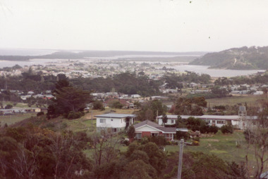
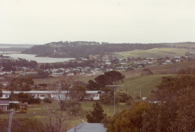
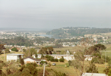
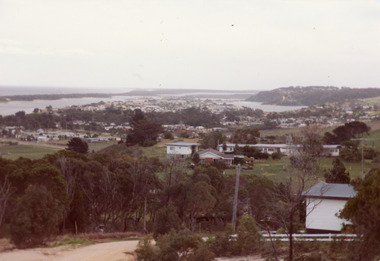
Photograph - Township, Fish, Marie, 1985c
\Colour photograph of township showing, North Arm and North Arm Bridge, Jemmys Point, Mount Barkly, Kalimna Heights on right, Cunninghame Arm and sand dunes on left. Looking towards Bullock Island and Rigby Island and Hopetoun Channel in centre background. Sea Vista flats in foreground. Photo take from near Telecom Tower on Merrangbaur Hill circa 1985. Lakes Entrance Victoria bridges, waterways, township -
 Lakes Entrance Historical Society
Photograph - Township, Fish, Marie, 1985c
Colour photograph of township showing, North Arm and North Arm Bridge, Jemmys Point, Mount Barkly, Kalimna Heights on right, Cunninghame Arm and sand dunes on left. Looking towards Bullock Island and Rigby Island and Hopetoun Channel in centre background. Sea Vista flats in foreground. Photo take from near Telecom Tower on Merrangbaur Hill circa 1985. Lakes Entrance Victoria bridges, waterways, township -
 Lakes Entrance Historical Society
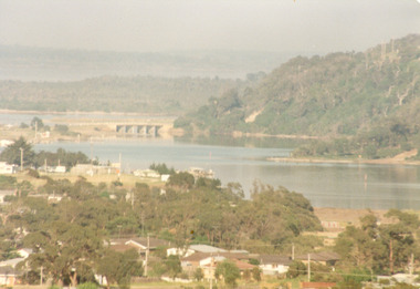
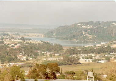
Photograph - Township, Fish, Marie, 1985c
Colour photograph, image of part of township, showing Jemmys Point, Mount Barkly, North Arm and old North Arm bridge, football ground mid picture. View towards Rigby Island, Hopetoun Channel and dunes. Photo taken using telephoto lenses from near Telecom Tower on Merrangbaur Hill. Lakes Entrance Victoria bridges, waterways, township -
 Lakes Entrance Historical Society
Photograph - Township, Fish, Marie, 1985c
Colour photograph of township, showing buildings, Jemmys Point, Mount Barkly, Kalimna Heights, North Arm and old North Arm bridge, and Rigby Island beyond. Sea Vista flats in foreground. Photo taken from near Telecom Tower on Merrangbaur Hill. Lakes Entrance Victoriatopography, township, waterways, bridges -
 Lakes Entrance Historical Society
Photograph - Township, Fish, Marie, 1985c
Colour photograph of part of township showing Jemmys Point, Mount Barkly, Kalimna Heights, North Arm & old North Arm bridge, looking beyond to Rigby Island. Photo taken from near Telecom Tower on Merrangbaur Hill. Lakes Entrance Victoriatopography, township, waterways, bridges -
 Lakes Entrance Historical Society
Photograph - Township
Colour photograph of township of Lakes Entrance showing North Arm, North Arm Bridge, Jemmys Point, Mount Barclay, Kalimna Heights, Cunningham Arm and sand dunes on left. Looking west to Bullock Island and Rigby Island. Photo taken from near Telecom Tower on Merrangbaur Hill. Lakes Entrance Victoria bridges, waterways, islands, township -
 Lakes Entrance Historical Society
Photograph - The Entrance, 1910c
Black and white photograph of the Princes Highway at Kalimna. It shows the road around Jemmys Point. Bullock Island and a distant view of the man made entrance. Gumtrees along roadside. Lakes Entrance VictoriaThe Entrance from Princes Highwayroads and streets, vegetation, fences, waterways -
 Lakes Entrance Historical Society
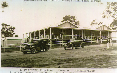
Photograph - Gainsborough House, 1925c
Gainsborough House was built of boxed poured concrete by Leslie Paynter and his father William Henry Paynter. It was opened about Christmas 1923 or 1924.Black and white photograph of Gainsborough House, Jemmys Point, showing an attractive accommodation house with veranda on front and north side. It is of concrete construction with iron roof. Guests on veranda and couple standing on road. Two soft top motor cars parked on road. Lakes Entrance VictoriaGainsborough House Jemmys Point Lakes Entrance.L Paynter, Proprietor, Phone 46, Moderate Tariff. Excellent Cuisine, Golf, Tennis, Shooting, Fishing, Surfing, Bathing.guesthouses, transport, people -
 Lakes Entrance Historical Society
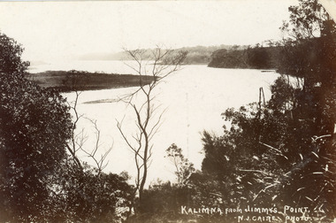
Postcard - Reeves Channel, Caire Nicholas John, 1905c
Also black and white enlargement 16 x 25Black and white postcard of the lake below Jemmys Point, Gippsland Lakes, showing Rigby Island opposite the steep cliffs of Kalimna and Nungurner shores of lakes. Small island, known as the Doughboy of Rigby Island. View taken from Jemmys Point with natural vegetation in foreground. Lakes Entrance VictoriaKalimna from Jimmys Pointislands, waterways, topography, boats and boating -
 Lakes Entrance Historical Society
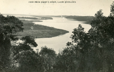
Postcard - Gippsland Lakes, Bulmer and Segerberg, 1915c
Black and white postcard of the Gippsland lakes, taken from Jemmys Point. It shows Rigby Island, Fraser Island and Flannagan Island, Reeves Channel. Natural vegetation in foreground. Lakes Entrance VictoriaView from Jimmy's Point Lakes Entranceislands, waterways, topography -
 Lakes Entrance Historical Society
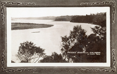
Photograph - Reeves River, 1910c
Also another copy print 8 x 13, both printed as though framedBlack and white photograph of Reeves Channel, Gippsland Lakes. It shows Rigby Island opposite the steep cliffs of mainland shore. Small island off Rigby was known as the Doughboy. Taken from Jemmys Point, natural vegetation in foreground. Lakes Entrance VictoriaReeves River from Kalimnaislands, waterways, topography -
 Lakes Entrance Historical Society
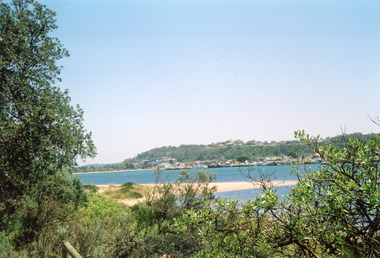
Photograph - Lakes Entrance, Davies, Judy, 2005c
Colour photograph of Jemmys Point, Kalimna Heights, and the Western end of the township, taken from the southern shore of Cunninghame Arm. Small sand spit and natural vegetation in foreground. Lakes Entrance Victoriajetties, waterways, topography, township -
 Lakes Entrance Historical Society
Photograph - S.S. Gippsland, 1920c
Black and white photograph of the steamer Gippsland leaving the Kalimna Jetty Gippsland Lakes Victoria. It shows the steep cliffs of Jemmys Point Bullock Island and entrance in the background. Lakes Entrance VictoriaKalimna Cove and Jetty Gippsland Lakesjetties, topography, ships and shipping -
 Lakes Entrance Historical Society
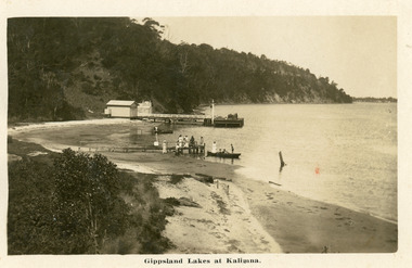
Postcard - Kalimna Jetty, 1920c
Personal message on back of postcardBlack and white postcard of Kalimna Jetty. It shows a jetty and landing with sheds, also shows seven people on rustic jetty in middle of photo, four people in boat. Jemmys Point road cutting in background. Lakes Entrance VictoriaGippsland Lakes at Kalimnajetties, waterways, tourism, boats and boating -
 Lakes Entrance Historical Society
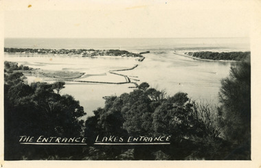
Postcard - The Entrance, 1940c
Also one similar images, 7 x 12.5, donated by Pam Cole, Lara VicBlack and white postcard of Bullock Island, and rock groynes, Reeves and Entrance Channels and Carpenter Town at the New Works, taken from Jemmys Point, dense vegetation in foreground. Lakes Entrance VictoriaThe Entrance Lakes Entrance waterways, topography, township