Showing 678 items
matching junction road
-
 Eltham District Historical Society Inc
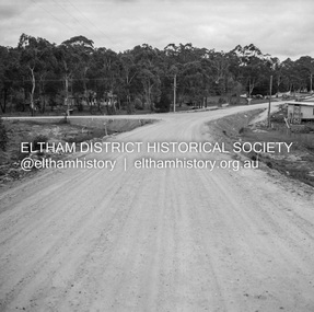
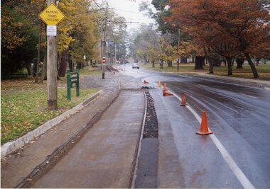
Negative - Photograph, J.A. McDonald, Heidelberg-Kinglake Road, Hurstbridge, Sep. 1959
... Cherrytree Road junction September 1959... Cherrytree Road junction September 1959 Record of various Shire ...During reconstruction of approaches looking towards Cherrytree Road junction September 1959Record of various Shire of Eltham infrastructure works undertaken during the period of 1952-1962 involving bridge and road reconstruction projects, sometimes with Eltham Shire Council Project Reference numbers quoted. It was during this period that a number of significant improvements were made to roads and new bridges constructed within the shire that remain in place as of present day (2022). In many situations, the photos provide a tangible visible record of infrastructure that existed throughout the early days of the Shire. The album was put together by or under the direction of the Shire Engineer, J.A. McDonald.infrastructure, shire of eltham, bridge construction, cherry tree road, hurstbridge, road construction -
 Whitehorse Historical Society Inc.
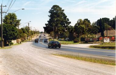
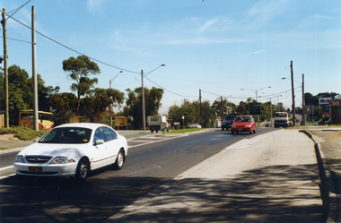
Photograph, Prior to Widening of Mitcham Road, 1/02/2000 12:00:00 AM
... Springvale Road Junction. Donvale Nursery on right. Taken prior... photograph of Mitcham Road looking towards Springvale Road Junction ...Coloured photograph of Mitcham Road looking towards Springvale Road Junction. Donvale Nursery on right. Taken prior to construction to widen Mitcham Road.mitcham road, donvale, springvale road -
![Cotham Road [Kew]](/media/collectors/550653872162f11fb04854aa/items/6132d605e06408664db73aee/item-media/6132d631e06408664db73d5f/item-fit-380x285.jpg) Kew Historical Society Inc
Kew Historical Society IncPhotograph - Cotham Road [Kew], c.1985
... Original colour positive photograph of the junction... colour positive photograph of the junction of Cotham Road ...Original colour positive photograph of the junction of Cotham Road and High Street in Kew, showing businesses of the period, including the Westpac Bank (left), the Greyhound Hotel, Coles and the newsagency (right)"Cotham Rd"cotham road, high street -- kew (vic.), roads -
 Melbourne Tram Museum
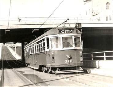
Photograph - Black & White Photograph/s, Melbourne & Metropolitan Tramways Board (MMTB), c July 1970
... inbound on route 5 passing under the St Kilda Junction road over... inbound on route 5 passing under the St Kilda Junction road over ...Black and white photograph - large format - of tram W6 940 inbound on route 5 passing under the St Kilda Junction road over bridge with Queens Way St Kilda reserve track in the background. The tram has the destination of City. The tram was the first to be fitted with marker lights - noted in Bourke St 3/7, Herald Sun 3/7 following strong public pressure. See page 5 of the June 1970 issue of Monarail, the magazine of the Monash University Railway club. See also image i2, from the June 1970 issue of TMSV Running Journal with a photo of the tram at the time of the launch. Image provided by Mal Rowe 30-9-2018.trams, tramways, st kilda junction, w6 class, queens way, tram 940 -
 Halls Gap & Grampians Historical Society
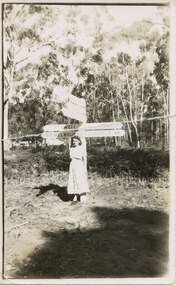
Photograph - B/W, C 1950s (?)
... at a road junction. The visible signs read "17 Stawell" and "163... at a road junction. The visible signs read "17 Stawell" and "163 ...The woman is Mrs. Ron Groves, formerly Dulcie Stevenson, Cheltenham.The photo shows a woman standing in front of road signs at a road junction. The visible signs read "17 Stawell" and "163 Melbourne" to the left and "Halls Gap 1" and "Dunkeld 49" to the right.people, tourists -
 Melbourne Tram Museum
Photograph - Black and White photograph, 1967
... about to leave the junction at Flemington Road and run through... the junction at Flemington Road and run through Royal Park. The tram ...Black and White photograph of W5 790, Route 56, West Coburg about to leave the junction at Flemington Road and run through Royal Park. The tram shelter and cross over are in the view.On rear in ink "Melbourne Vic (1967)"trams, tramways, w5 class, royal park, flemington road, route 56, shelters, tram 790 -
 Rutherglen Historical Society
Image
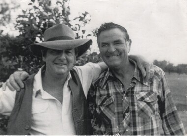
... Photograph was found on the road at the junction of Jacks...-country Photograph was found on the road at the junction of Jacks ...Photograph was found on the road at the junction of Jacks Road and the Murray Valley Highway by Ian Stones, a member of the Rutherglen Historical Society. We do not know the identity of the man with Slim Dusty.Photo of Slim Dusty & unknown man ?slim dusty -
 Melbourne Tram Museum
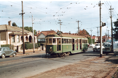
Photograph - Tram 415 - Riversdale Road, Travis Jeffrey, mid 1950s
... 74), at the junction in Riversdale Road for Camberwell Depot... 74), at the junction in Riversdale Road for Camberwell Depot ...Colour print showing W2 class tram No. 414 (Burwood Route 74), at the junction in Riversdale Road for Camberwell Depot. Note the signal light on the pole on the right hand side of the photograph.Yields information about tram 415 and the junction with the Camberwell Depot tracks.Colour print on Fujichrome paper.trams, tramways, tram 415, riversdale road, cambewell depot -
 Eltham District Historical Society Inc
Photograph, Kinglake near shops
... Three colour photographs showing the various road junctions... the various road junctions near Kinglake shops. 1. St Andrews Road ...Three colour photographs showing the various road junctions near Kinglake shops. 1. St Andrews Road, Kinglake on left; Toolangi Road to left before roundabout 2. Whittlesea Road on left with Kinglake Hotel 3.kinglake, kinglake whittlesea road, hurstbridge road, kinglake healesville road -
 Ringwood and District Historical Society
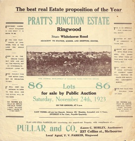
Flyer, Brochure for Land Sale By Public Auction, Pratt's Junction Estate, Ringwood, Victoria - 1923
... , Georges Road, Junction Street, and six room weatherboard villa... Whitehorse Road, Oliver Street, Georges Road, Junction Street ...Folded double-sided brochure advertising 86 residential lots for sale by Public Auction at 3pm, Saturday, November 24th, 1923, with town photographs, map of subdivision and summary of local features and services. Subdivision plan includes Whitehorse Road, Oliver Street, Georges Road, Junction Street, and six room weatherboard villa for sale. Local Agent - F.V. Parker, Ringwood. -
 Bendigo Historical Society Inc.
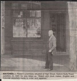
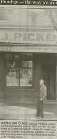
Newspaper - JENNY FOLEY COLLECTION: WATCHES
... . Picken's premises, situated at High Street, Sailors Gully Road..., situated at High Street, Sailors Gully Road Junction. In 1901 he ...Bendigo Advertiser "The way we were" from 1999. Watches: J. Picken's premises, situated at High Street, Sailors Gully Road Junction. In 1901 he was listed as "atch anc clock maker, English and Colonial jewlerry made to order and repaired"newspaper, bendigo advertiser, the way we were -
 Melbourne Tram Museum
Negative, Wal Jack collection, c1930
... or 355 in St Kilda Road Melbourne at junction with City Road... of W2 255 or 355 in St Kilda Road Melbourne at junction ...Black and white negative from Wal Jack collection of W2 255 or 355 in St Kilda Road Melbourne at junction with City Road, with route number 7 showing. Photo c1930. Photo may not be by Wal Jack as a size that he did not use.trams, tramways, st kilda road, city road, route 7, w2 class, tram 255?, tram 355? -
 Melbourne Tram Museum
Photograph - Dandenong and Glenferrie Roads, c1950
... for the junction with Hawthorn Road. Shows the centre poles, the closest... for the junction with Hawthorn Road. Shows the centre poles, the closest ...Photo looking west shows the curve from Dandenong Road into Glenferrie Road. In the background is a shelter at the stop for the junction with Hawthorn Road. Shows the centre poles, the closest one being fitted with a section insulator with associated wiring and the trees along the central reservation. Photo c1950.Yields information about Dandenong Road at Glenferrie Road.Black and White photograph with note on the rear.In pencil "Dandenong & Glenferrie Roads"tramways, dandenong road, central poles, shelters -
 Ballarat Tramway Museum
Photograph - Black & White Photograph/s - set of 2, Sep. 1971
... , promoting Ballarat. .1 - St Kilda Road - Domain Junction area - St... Junction area - St Kilda Road .2 - Domain Road - after using ...Yields information through a photograph of Ballarat No. 36 in Melbourne for Tourism Week in September 1971and its use in Melbourne. Two black and white photographs of Ballarat No. 36, after closure of the Ballarat system in Melbourne, for Tourism Week, promoting Ballarat. .1 - St Kilda Road - Domain Junction area - St Kilda Road .2 - Domain Road - after using the crossover - with W6 953? alongside. See Reg item 3501 for photos of its transport to Melbourne, 3503 for colour postcard and 3432 for a newspaper clipping. Both photographs have been used for display purposes. Photographer unknown.tramways, trams, melbourne, tourism, mmtb, domain road, tram 36 -
 Whitehorse Historical Society Inc.
Photograph, Prior to Construction of Mitcham Road, 1/02/2000 12:00:00 AM
... Springvale Road Junction. Donvale Bus Terminus on left, Mobil... photograph of Mitcham Road, looking towards Springvale Road Junction ...Coloured photograph of Mitcham Road, looking towards Springvale Road Junction. Donvale Bus Terminus on left, Mobil Service Station on right, as is a small shopping centre which consisted in earlier days as only a family operated general store. This photograph was taken just prior to widening of Mitcham Road.mitcham road, donvale, springvale road -
 Melbourne Tram Museum
Document - Research Notes, H. S. McComb, development and timing of the "PMTT" part 3, 1950's
... , bridges, track miles, junctions: Kew Junction, Glen Huntly Road... Junction, Glen Huntly Road, Glenhuntly Road, Victoria St cable tram ...Set of papers, handwritten concerning the development and timing of the "PMTT", Prahran and Malvern - about 30 sheets. Prepared by H. S. McComb - gives layout of the PMTT system, of track layout, opening dates, sketches of various junctions, bridges, track miles, junctions: Kew Junction, Glen Huntly Road, Glenhuntly Road, Victoria St cable tram terminus, Barkers Road, Commercial Road, Malvern Road, Hawthorn Road, Balaclava Junction, Caulfield station loop, Glenferrie Road. Items 2041 to 2052 within box 72.3 in a brown folder marked "PMTT" in red pencil.trams, tramways, pmtt, malvern, routes, track, kew junction, victoria st, barkers rd, glenhuntly rd, malvern rd, caulfield, hawthorn rd, balaclava rd, balaclava junction, glenferrie rd -
 Hume City Civic Collection
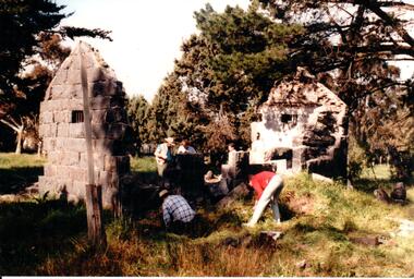
Photograph, c 1993
... at The Gap which was south of the junction of Gap Road (Sunbury Road... at The Gap which was south of the junction of Gap Road (Sunbury Road ...Aitkens Gap Police Lock up was originally constructed at The Gap which was south of the junction of Gap Road (Sunbury Road) and Calder Highway (Victoria St/Mt. Alexander Road). It was part of a police complex which was a changeover station for the gaol escort. The goal was relocated and rebuilt in the police station grounds in Sunbury in 1993.A coloured photograph of five men working on the removal of Aitkens Gap Gaol from its original site. Two end walls of the gaol are standing and the work is being done on the front and back of the building. Conifers and cypress trees are growing around the site.peter free, aitkens gap gaol, police historical association, sunbury police station, george evans collection -
 Bendigo Historical Society Inc.
Newspaper - JENNY FOLET COLLECTION: WATCH AND CLOCK
... were on the High Street and Sailors Gully Road junction... and Sailors Gully Road junction. The clip is in a folder. Newspaper ...Bendigo Advertiser ''The way we were'' from 2000. Watch and clock: James Pickens established his business prior to 1872. In 1901 he was listed as ''watch and clock'' maker. He made and repaired English and colonial jewellery to order. The premises were on the High Street and Sailors Gully Road junction. The clip is in a folder.newspaper, bendigo advertiser, the way we were -
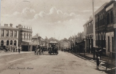 Kew Historical Society Inc
Postcard, Main Street, Kew, c.1890
... ], Kew, looking south west from near its junction with Cotham... its junction with Cotham Road, showing: Ryan’s Council Family ...The Kew Historical Society's Pictures Collection is comprised of photographs, postcards and original works of art. The postcards include original (mainly) images dating from the 1900s to the present. A number of postcards, some of which have numerous variants, were published as parts of series. Others are original images customised as postcards. Many of the postcards in the collection depict places within the suburbs of Kew and Kew East. Others depict locations in Victoria or internationally. A monochrome postcard showing Main Street [High Street], Kew, looking south west from near its junction with Cotham Road, showing: Ryan’s Council Family Hotel, T. G. Jellis (baker, confectioner), Herbert King (undertaker), L. Merritt (boot warehouse), horse tram, horse drawn vehicles and pedestrians.Post card text addressed to Miss Newell of Balmain.high street - kew, cotham road - kew, tramways - kew -
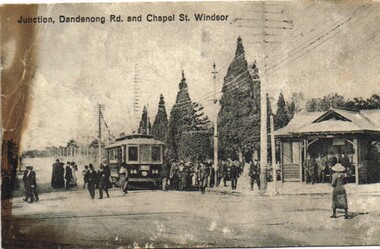 Melbourne Tram Museum
Postcard, "Junction, Dandenong Rd and Chapel St Windsor", c1910
... Postcard photo of PMTT tram 14 at the junction... Postcard photo of PMTT tram 14 at the junction of Dandenong Road ...Postcard photo of PMTT tram 14 at the junction of Dandenong Road and Chapel St Windsor with many people either leaving or joining the tram. On the right hand side is a PMTT shelter with a number of people standing in it. Divided back with spaces for Correspondence, address and stamp. Stamp area has "Printed in county of Saxony" and number 3949 in bottom right hand corner.trams, tramways, pmtt, dandenong rd, chapel st, shelters, tram 14 -
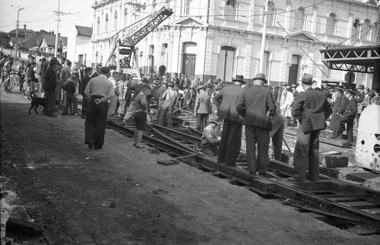 Melbourne Tram Museum
Negative, Wal Jack, 17/05/1942 12:00:00 AM
... of the junction between Union Road and Maribyrnong Road, Ascot Vale... of the junction between Union Road and Maribyrnong Road, Ascot Vale. Shows ...Black and white negative, by Wal Jack, of the installation of the junction between Union Road and Maribyrnong Road, Ascot Vale. Shows a W Leech mobile crane, a few workers and many bystanders supervising the work. Two uniformed tramway (driver and conductor) are on the right hand side of the photograph. In the background is the Union Hotel. Photo dated 17-05-1942 in the Wal Jack album along with details of the location.trams, tramways, trackwork, union road, maribyrnong rd, new tramway -
 Surrey Hills Historical Society Collection
Book, A History of Camberwell, 1964
... Junction and Burke Road, pre 1950's era. Electric transport 1916... photographs of Camberwell Junction and Burke Road, pre 1950's era ...Includes description including photographs of Camberwell Junction and Burke Road, pre 1950's era. Electric transport 1916-1925, tools and waterways. Published [Brisbane] : Jacaranda Press in association with the Camberwell City Council, 1964 From estate of Ken Hall; Cheryl Poustie was Ken's daughter. Records in detail history and development of the Melbourne suburb of Camberwell. A city covering thirteen square miles. Begins with first European settlement in 1835 by John Gardiner - ending at 1960.Records in detail history and development of the Melbourne suburb of Camberwell. A city covering thirteen square miles. Begins with first European settlement in 1835 by John Gardiner - ending at 1960.Title Page: Kenneth T.Hall / 89-4418camberwell - history, (mr) john gardiner, outer circle railway, camberwell (vic) - history, broughton hall -
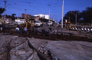
 Ballarat Tramway Museum
Photograph - Colour Photograph/s - set of 3, Carolyn Dean, 20/05/2004 12:00:00 AM
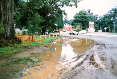
... - To the south of depot junction. .3 - Preparing the road surface... junction. .3 - Preparing the road surface for the next pavement ...Set of three photographs taken on 20/05/2004 of the tram track pavement reconstruction in Wendouree Parade. Photo by Carolyn Dean. .1 - Depot junction, looking south, not the warning trams crossing and cyclist sign on the pole. .2 - To the south of depot junction. .3 - Preparing the road surface for the next pavement layer.On rear of each photo in ink, "20/05/04", "Photo by Carolyn Dean"road works, wendouree parade -
 Glen Eira Historical Society
Document - Caulfield Fire Station, No 26, Tree Reserve, Dandenong Road
... of properties in the neighbourhood of the junction of Dandenong Road... between owners of properties in the neighbourhood of the junction ...A three page photocopy of a handwritten memorandum of agreement dated 11/10/1894 between the municipalities of Caulfield and Malvern and the Metropolitan Fire Brigades Board consenting to the erection of a fire station on Tree Reserve. Also a three page photocopy of a handwritten agreement dated 11/10/1894 between owners of properties in the neighbourhood of the junction of Dandenong Road and Waverly Road and the Metropolitan Fire Bridgades Board to allow the Board to erect and use a fire station on Tree Reserve in Dandenong Road. The agreement was signed by the property owners.caulfield east, shire of caulfield, tree reserve, caulfield fire station, rs anderson and son, fire stations, legal documents, lloyd c d, jowett f, delves catherine , catani c, federal building society, st james building society, nathan philip, trustees of the late john nathan, adams j, bates j -
 Eltham District Historical Society Inc
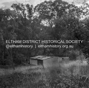
Negative - Photograph, J.A. McDonald, Road Reserve Housing, Mar. 1961
... wer at the junction of Flat Rock Road and Cherry Tree Road... were built wer at the junction of Flat Rock Road and Cherry ...Shack built on road reserve without permit Most probably up on Simms Road, Kinglake Other areas where illegal shacks were built wer at the junction of Flat Rock Road and Cherry Tree Road, Hurstbridge. At times, Building Surveyor George E Newton would have to attend to these shacks for inspection and issue demolition ordersRecord of various Shire of Eltham infrastructure works undertaken during the period of 1952-1962 involving bridge and road reconstruction projects, sometimes with Eltham Shire Council Project Reference numbers quoted. It was during this period that a number of significant improvements were made to roads and new bridges constructed within the shire that remain in place as of present day (2022). In many situations, the photos provide a tangible visible record of infrastructure that existed throughout the early days of the Shire. The album was put together by or under the direction of the Shire Engineer, J.A. McDonald.infrastructure, shire of eltham, 1961-03, building surveyor, cherry tree road, flat rock road, george e. newton, houses, hurstbridge, kinglake, road reserve, road reserve housing, scan - 120 format 6x6 negative, shack, simms road -
 Eltham District Historical Society Inc
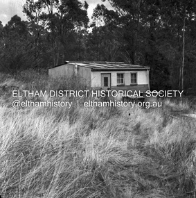
Negative - Photograph, J.A. McDonald, Road Reserve Housing, Mar. 1961
... wer at the junction of Flat Rock Road and Cherry Tree Road... were built wer at the junction of Flat Rock Road and Cherry ...Shack built on road reserve without permit Most probably up on Simms Road, Kinglake Other areas where illegal shacks were built wer at the junction of Flat Rock Road and Cherry Tree Road, Hurstbridge. At times, Building Surveyor George E Newton would have to attend to these shacks for inspection and issue demolition ordersRecord of various Shire of Eltham infrastructure works undertaken during the period of 1952-1962 involving bridge and road reconstruction projects, sometimes with Eltham Shire Council Project Reference numbers quoted. It was during this period that a number of significant improvements were made to roads and new bridges constructed within the shire that remain in place as of present day (2022). In many situations, the photos provide a tangible visible record of infrastructure that existed throughout the early days of the Shire. The album was put together by or under the direction of the Shire Engineer, J.A. McDonald.infrastructure, shire of eltham, 1961-03, building surveyor, cherry tree road, flat rock road, george e. newton, houses, hurstbridge, kinglake, road reserve, road reserve housing, scan - 120 format 6x6 negative, shack, simms road -
 Eltham District Historical Society Inc
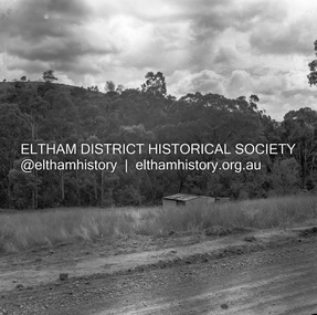
Negative - Photograph, J.A. McDonald, Road Reserve Housing, Mar. 1961
... were at the junction of Flat Rock Road and Cherry Tree Road... were built were at the junction of Flat Rock Road and Cherry ...Shack built on road reserve without permit Most probably up on Simms Road, Kinglake Other areas where illegal shacks were built were at the junction of Flat Rock Road and Cherry Tree Road, Hurstbridge. At times, Building Surveyor George E Newton would have to attend to these shacks for inspection and issue demolition ordersRecord of various Shire of Eltham infrastructure works undertaken during the period of 1952-1962 involving bridge and road reconstruction projects, sometimes with Eltham Shire Council Project Reference numbers quoted. It was during this period that a number of significant improvements were made to roads and new bridges constructed within the shire that remain in place as of present day (2022). In many situations, the photos provide a tangible visible record of infrastructure that existed throughout the early days of the Shire. The album was put together by or under the direction of the Shire Engineer, J.A. McDonald.infrastructure, shire of eltham, 1961-03, building surveyor, cherry tree road, flat rock road, george e. newton, houses, hurstbridge, kinglake, road reserve, road reserve housing, scan - 120 format 6x6 negative, shack, simms road -
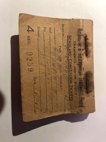 Melbourne Tram Museum
Ephemera - Ticket Blocks, Melbourne & Metropolitan Tramways Board (MMTB), "Scholars' Concession Tickets", mid 1940's
... Balaclava Junction and Barkers Road, via Glenferrie Road, for MLC... Junction and Barkers Road, via Glenferrie Road, for MLC school ...Ticket block formed from a preprinted card stapled to contain about 40 prepaid Scholars' Concession tickets that were given to the conductor at the time of the trip. Has the details on the front cover and terms of use on the rear. Handwritten in pencil (appears to be) - B. Cohen, Fol? 1550, for use between Balaclava Junction and Barkers Road, via Glenferrie Road, for MLC school issued 1/10/48? Book No. 9259. Has a "Malvern" stamp on the inside along with other ink and pencil notes.trams, tramways, tickets, schools tickets, scholar's tickets -
 Melbourne Tram Museum
Slide - Set of 2, Keith Kings, 5/05/1968 12:00:00 AM
... Fitzroy St and High St into St Kilda Road. Shows the old junction... Fitzroy St and High St into St Kilda Road. Shows the old junction ...Set of two 35mm Kodak white cardboard colour slide by Keith Kings of 5/5/1968 .1 - construction of new curves from Fitzroy St and High St into St Kilda Road. Shows the old junction trackwork and road height differences. Note the temporary tram stop. .2 - ditto, shows the trackwork for High St behind the hotel and the Junction Hotel with a large Dunlop sign and Rothmans cigarette advert. See Keith's slide notes.Keith Kings stamp and number "23-27 and 23-28", with details of exposure. .1 - St Kilda Jtn by pass work. installing new turnout for Fitzroy St. In new track, New level is lower. Old curves replaced after a day's work to all normal service to resume during weekdays. .2 - St Kilda Bypass work. Installing new turnout for Fitzroy St. In new track looking south. Old Jtn out of photo to the left. New concrete track ready at rear on right. Hotel (which will remain in the middle of everything!!)trams, tramways, st kilda junction, fitzroy st, st kilda rd, trackwork, high st -
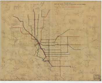 Melbourne Tram Museum
Drawing, Melbourne & Metropolitan Tramways Board (MMTB), "Route Map showing location of special work and pole numbers" "All night tram routes in colours", late 1941
... No. P5799. Shows crossovers, track layouts at junctions, signal... crossovers, track layouts at junctions, signal cabins roads, railways ...Map of the system shown at two inches = 1 mile. Drawing No. P5799. Shows crossovers, track layouts at junctions, signal cabins roads, railways, and stations. Originally signed by Perway Engineer - 20/12/1940, though originally drawn in 1922. Has been marked up in colour pencil to show the all-night routes and the individual services. The plan shows the lines to Maribyrnong Munitions works along Cordite Ave and Wests Road and the track from Moonee Ponds to Union Road, opened in July 1941, but not the extension to Essendon Airport built in 1942.Demonstrates a detail drawing of Melbourne tramways, junctions and pole numbers.Drawings - dyeline cloth-backed print - titled - "Route Map showing the location of special work and pole numbers" and subtitled - "All night tram routes in colours". trams, tramways, mmtb, trackwork, tramways, junction, map, world war 2, night trams