Showing 454 items matching "localities"
-
 Bendigo Historical Society Inc.
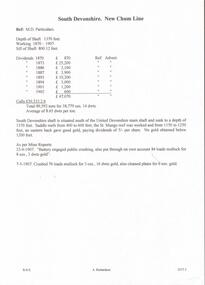
Document - DEVONSHIRE MINES - SOUTH DEVONSHIRE
Hand written notes on the South Devonshire Mine. Mentions depth, years of working, Dividends, Calls, gold yield, and locality. Extract from Mine Reports mentions amount of gold from loads of mullock.mine, gold, devonshire mines, devonshire mines, south devonshire, new chum line, united devonshire, st mungo reef -
 Whitehorse Historical Society Inc.
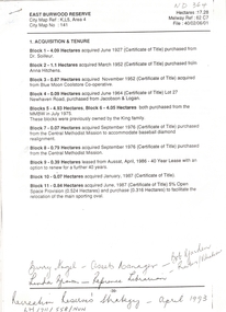
Letter - Correspondence, East Burwood Reserve, 1993
Various documents relating to the establishment of East Burwood ReserveVarious documents relating to the establishment of East Burwood Reserve including acquisition of land, details, plans, locality map, news cuttings and photographs. Appears to be copy of Nunawading City Council File April 1993Various documents relating to the establishment of East Burwood Reserve sportsgrounds, east burwood reserve, soilleur (dr), hitchens, anna, blue moon fruit co-operative ltd., jacobson and logan, king family, central methodist mission, aussat, tally ho, sewart, bill -
 Bendigo Historical Society Inc.
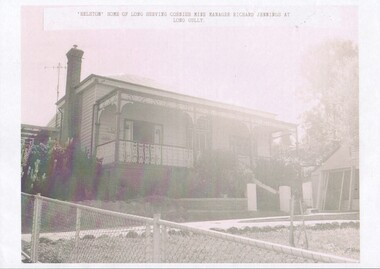
Photograph - "Helston" home of Richard Jennings
Richard Jennings was a native of Cambourne, in Cornwall, born c. 1831. He arrived in Victoria in 1851, returned to Cornwall and then came back to Bendigo. He was the manager of several mines in the Bendigo goldfields and retired from these posts in 1891. His home "Helston" is in Backhaus St. Long Gully. Richard died in Feb. 1917 and was buried at the White Hills Cemetery.10563.5 Home of long serving Cornish Mine Manager Richard Jennings, who died at his residence "Helston" at Back Street, Long Gully. He was aged 86 years, and was one of the pioneers of the localityrichard jennings, long gully, "helston" -
 Lakes Entrance Historical Society
Book, Rogers, J. G. and Hellyer, Nellie, Lonely Graves of the Gippsland Goldfields and Greater Gippsland, 1994
Description of burial sites and details of circumstances of deaths of many persons buried in lonely and out of the way places across Gippsland. Indexed under locality and family name. Contains bibliography and glossary of causes of death.Nelly Hellier, J.G. Rogers. Aug.1994bibliography, cemeteries -
 Ballarat Heritage Services
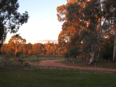
Photograph - Photograph - Colour, Clare Gervasoni, Evening View at Clydesdale, Victoria, 2018, 14/05/2018
Located in Central Victoria, Clydesdale is a locality in Hepburn Shire.Colour photograph of the bush around Clydesdale, Victoriaclydesdale, landscape, bush -
 Ringwood and District Historical Society
Flyer, Executor's Auction Subdivision Advertisement, Lilydale Road and Oban Road, Ringwood East, Vic. - 1937
Single page advertisement for Executor's Auction of land in Ringwood East on Saturday, May 29, 1937 with locality map showing 26 building sites for auction highlighted in brown, and brief summary of local services available. Subdivision includes Old Lilydale Road, Joseph Street, Dynes Street, Albert Street (later Wyrunga Street), Carcoola Road, and Mount Dandeong Road. (Carcoola Road incorrectly shown as Oban Road on the subdivision plan). Auctioneer - C.E. Carter, (Phone Ringwood 24. -
Canterbury History Group
Ephemera - Maling's Tramway Estate, 1924
Brochure for the auction on 13 December 1924 of 40 building blocks comprising the Maling's Tramway Estate, Balwyn. Includes a small locality plan giving comparative prices per foot of land for some other suburbs.balwyn, malings tramway estate, land sales, land subdivision, shepreth street, the willows, meldreth street, whitehorse road, banool road, maling family, arthur tuckett & son, geo. m. hume -
 Bendigo Historical Society Inc.
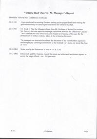
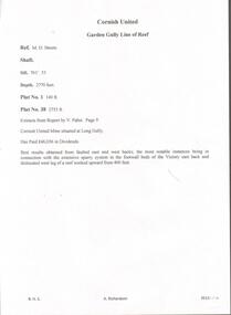
Document - VICTORIA QUARTZ - NOTES ON THE VICTORIA QUARTZ MINE
Three typed and one handwritten copies of notes on the Victoria Quartz Mine. Notes include Size of Lease, Depth of Shaft, Locality, P;lant, Early History, Leading & Prominent, Best Gold and Gold Yield.document, gold, victoria quartz, victoria quartz, notes on the victoria quartz mine, goldmines hotel, mr william rae, lansell's 180, mr e j dunn, geological branch of the mines department, new chum railway mine, new chum drainage association, mines dept special edition australian mining standard 1/6/1899, mines dept booklet 'bendigo goldfield' 1936, mines dept annual and quarterly reports, annals of bendigo, a richardson -
 Bendigo Historical Society Inc.
Document - GREAT SOUTHERN MINE - GREAT SOUTHERN GARDEN GULLY
Hand written notes, with typed copy of same, on the locality of the Great Southern Mine on the Garden Gully reef between Dead Dog and Dead Cat Gullies. Check up written at the top. Albert Richardson Collectionmine, gold, great southern mine, great southern mine, great southern garden gully ext'd -
 Bendigo Historical Society Inc.
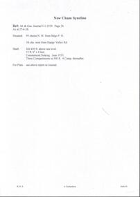
Document - MINING REPORTS - NEW CHUM SYNCLINE
Handwritten notes with the locality of the New Chum Syncline, the height of the sill above sea level, size of the shaft, commenced Sinking in June 1935. Ref: M. & Geo. Journal 1 - 1 - 1939. Page 26.document, gold, mining reports, new chum syncline, m & geo journal, bendigo p o -
 The Beechworth Burke Museum
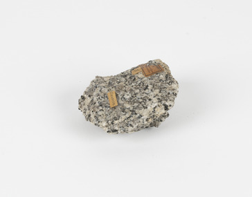
Geological specimen - Granodiorite, Unknown
This specimen was found in Harcourt, Victoria. Harcourt is a small historic gold rush town located in a valley at the foot of Mount Alexander (741 m) in the Central Highlands of Victoria. In recent times the goldrush origins of the town have been replaced by a district known for apples, cider and wine. The Traditional owners of Harcourt are The Dja Dja Wurrung people. Granodiorite is a coarse-grained intrusive igneous rock similar to granite, but containing more plagioclase feldspar than orthoclase feldspar. Granodiorite has greater than 20% quartz by volume, and between 65% and 90% of the feldspar is plagioclase. This piece is of significance due to its provenance in Harcourt, Vic. Granodiorite is commonly produced in volcanic arcs, and in mountain buildings where it emplaces as large batholiths in mountain roots. Granodiorite is the plutonic equivalent of dacite. This specimen is part of a larger collection of geological and mineral specimens collected from around Australia (and some parts of the world) and donated to the Burke Museum between 1868-1880. A large percentage of these specimens were collected in Victoria as part of the Geological Survey of Victoria that begun in 1852 (in response to the Gold Rush) to study and map the geology of Victoria. Collecting geological specimens was an important part of mapping and understanding the scientific makeup of the earth. Many of these specimens were sent to research and collecting organisations across Australia, including the Burke Museum, to educate and encourage further study.Granodiorite is a coarse-grained intrusive igneous rock similar to granite, but containing more plagioclase feldspar than orthoclase feldspar. According to the QAPF diagram, granodiorite has a greater than 20% quartz by volume, and between 65% and 90% of the feldspar is plagioclase.GRANDIORITE. / Locality: / Harcourt, Victoria / Other label: Geological survey / R S / Loc Harcourt quarries [?] Alexander / 1/4 Sheet. | 4 | Granite /granodiorite, granite, burke museum, harcourt, coarse-grained, igneous, plagioclase feldspar, orthoclase feldspar, quartz, mount alexander, the dja dja wurrung people, the traditional owners, central highlands of victoria, gold rush -
 The Beechworth Burke Museum
Geological specimen - Precious Opal
In Australia, precious opal is found in Cretaceous age sandstones and mudstones. These sedimentary rocks were deeply weathered and this weathering released silica into the groundwater.Australia is the only part of the world where opalised animal and plant fossils have been found. Opal artefacts several thousands of years old have been discovered in East Africa. As early as 250 BC the Romans prized opals, thought to have come from mines in Eastern Europe, the ancient world's main source of opals. There are many aboriginal dreamtime stories that feature opal. Australian opals discovered during the late 1800's found little favour with European markets but their commercial value increased in the 1900's and in 1932 Australia took over as the major producer of opals in the world and remains the largest producer to this day. Opal is found around the world (Brazil, Mexico, Honduras and the western US) however Australia produces 95% of the world's precious opal and it is our official national gemstone. Opal was first mined commercially at Listowel Downs in Queensland in 1875 and later at White Cliffs in NSW. Today, Coober Pedy (SA) is the main producer of white opal, though in recent years this field has expanded and all types of opals are found. Other centres in SA include Andamooka and Mintabe. Lightning Ridge (NSW) is renowned for black opal and formerly White Cliffs was a large producer of high quality opal. Boulder opals (opals in concretionary ironstone) are mined in Queensland from numerous localities in a zone extending from the Eulo and Cunnamulla district in the south and northwest for a distance of over 700 km to Kynuna in the north. The towns of Quilpie, Yowah and Winton are the main opal mining and wholesale centres. Opals are considered gemstones and have been used in jewellery for thousands of years.Throughout much of history, opals were actually believed to be good luck. The Romans thought that opals were one of the luckiest gemstones and a symbol of hope. In the Middle Ages, opals were believed to be bestowed with all the positive properties of coloured gemstones due to its rainbow-like play of colour. Finally, there is a superstition that you should not wear an opal unless it is your birthstone otherwise misfortune will befall you. This, of course, is far-fetched, but the notion could have been promoted in the late 19th and early 20th Centuries by diamond traders who were trying to increase sales of diamonds and deter people from buying opals. Possibly related to this is the thought that you should set opal jewellery with diamonds as their powers of good fortune will override any negativity held by the opal. The great majority of opal does not show play of colour and is called common opal or potch however this is not the case with a precious opal. Opal is a precious gemstone, like rubies, emeralds or diamonds. Opal is rare, and it is expensive to prospect and mine for.Silica is one of the most common minerals on the planet, but precious opal is very rare – far more rare than diamonds. Precious opal is rare because the natural processes that create it rarely occur.Most (at least 95%) of the opal found by miners is common opal without gem colour. In Australia we call it potch. It can be white, grey, black or amber coloured. Even when a miner finds gem-coloured opal, most of it can’t be cut into gemstones because it’s too thin, or sandy. This specimen is part of a larger collection of geological and mineral specimens collected from around Australia (and some parts of the world) and donated to the Burke Museum between 1868-1880. A large percentage of these specimens were collected in Victoria as part of the Geological Survey of Victoria that begun in 1852 (in response to the Gold Rush) to study and map the geology of Victoria. Collecting geological specimens was an important part of mapping and understanding the scientific makeup of the earth. Many of these specimens were sent to research and collecting organisations across Australia, including the Burke Museum, to educate and encourage further study.It is not known where this opal originated, except that it is probably from Victoria, as it has been recorded from many localities in the State. Common Opal is formed from silica-rich water circulating through rocks near the Earth’s surface. It consists of minute spheres of silica arranged in different ways. In common opal, the spheres are of different sizes and randomly arranged, unlike in precious opal where the spheres are of similar size and uniformly arranged in three dimensions. These differences account for common opal generally being translucent to opaque and without the play of colours, or opalescence, displayed by precious opal. Common opal is found in many localities and different geological environments throughout Australia and the world. Precious opal requires special conditions to form and is much less common. Australia produces most to the world’s precious opal. burke museum, beechworth, indigo shire, beechworth museum, geological, geological specimen, precious opal, opal, brazil, mexico, honduras, queensland, coober pedy, gemstones, jewellery, play-of-colour, light blue -
 Bendigo Historical Society Inc.
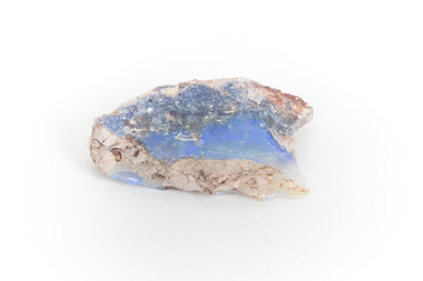
Document - NEW ARGUS MINE - NOTES ON THE NEW ARGUS MINE
One handwritten and four typed copies of notes on the New Argus Mine at Eaglehawk. One typed copy has a locality map attached. Notes mention locality, depth of shaft, early history, prominence, amount of gold obtained and production. References; Special Edition Australian Mining Standard 1/6/1899, Mines Dept. Booklet 'Bendigo Goldfield' 1936, Mines Department Annual and Special Reports, Annals of Bendigo Mining Section 1886 - 1922 and A. Richardson. 4 Typewritten copies of this item have not been scanned.document, gold, new argus mine, new argus mine, notes on the new argus mine, eaglehawk, specimen hill mine, mr cave, mr amos, the argus mine, north specimen hill mine, adlinga and pascoe & co, new hopeful, bendigo amalgamated goldfields, special edition australian mining standard 1/6/1899, mines dept. booklet 'bendigo goldfield 1936, mines dept. annual and special reports, annals of bendigo mining section 1886 - 1922, a richardson -
 Bendigo Historical Society Inc.
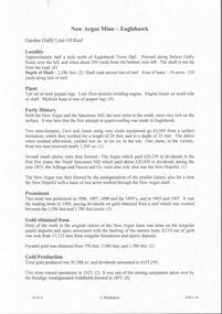
Document - CORNISH UNITED MINE - EXTRACTS FROM REPORT BY V PABST
Hand written notes from a report by V. Pabst. Notes include depth of shaft, depth of Plat Nos 1 & 38, locality, Dividends paid and the best places where gold was found. Victory also mentioned.mine, gold, cornish united mine, cornish united mine, extracts from report by v. pabst, dividends paid, v. pabst, victory -
 Ringwood and District Historical Society
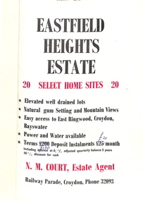
Flyer, Land Sale Brochure, Eastfield Heights Estate, Croydon. (Undated, circa 1950s)
Bi-fold advertisement for 20 residential allotments with locality map of East Ringwood-Croydon area and map of subdivision bounded by Eastfield Road, and The Pass, Croydon. Agent - N.M. Court, Railway Parade, Croydon, Phone 32093. -
 Buninyong & District Historical Society
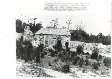
Photograph - Photograph of Original Photograph, Hughes family of Lal Lal, 1870's, 1870s
historic, social, familyIn Lal Lal forest, Hughes family in front of primitive bark miner's hut with shingle roof, rough stone chimney on left, parents and youngest daughter standing, two older daughters seated, scrubby grass in foreground, rough picket fence and a cow. incomplete label: "...diggings having been worked out, the inhabitantshave gradually left the locality, and Mr. and Mrs. Hughes only remain. They live in a remote part of the forest." lal lal, hughes family, miner's cottage -
 Bendigo Historical Society Inc.
Document - LANDS OFFICE: SANDHURST LAND SALES 1865 - 1869, 1865 - 1869
Document: green hard cover journal. Red spine and corners. Contains name index to areas in Sandhurst region, including rural areas. LH page: allots. secs., locality, page book. RH page: same information.Lands Officeplace, bendigo, land sales, bendigo, sandhurst, land sales, land surveyed -
 Bendigo Historical Society Inc.
Document - UNITED HUSTLERS AND REDAN - NOTES ON THE UNITED HUSTLERS AND REDAN
One handwritten and three typed copies of notes on the United Hustlers and Redan mine. Notes include locality, plant, early history, Prominence, best gold, k. K. Shaft, Total gold production and dividends and Origin of Names.document, gold, united hustlers and redan, united hustlers and redan, notes on the united hustlers and redan, the south or k k shaft, the hustlers, redan, little, white, ragman's, maiden, williamsons, bignall's, the alabama company, k k company, new hustlers and redan, united pioneers, lady darling, hibernia, red white and blue, sophia, redan, north comet, go-a-head, cosmopolitan, johnsons, geo lansell, bendigo amalgamated goldfields company, kocks, kock's koh-i-nor, mines dept booklet bendigo goldfield geo brown 1936, mines dept annual and quarterly reports, mines dept bulletin no 33 h herman 1913, annals of bendigo mining sections 1878 to 1920, a richardson -
 Bendigo Historical Society Inc.
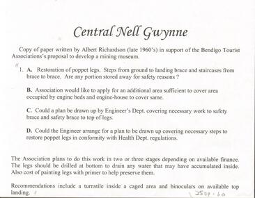
Document - CENTRAL NELL GWYNNE - DESCRIPTION OF THE CENTRAL NELL GWYNNE
2 typed carbon copies of locality, plant, early history, revival period, dividends and gold production of the Central Nell Gwynne. 1st copy images 3509.6a,6b,6c, 2nd copy images 3509.6d,6e,6f,mine, gold, central nell gwynne, central nell gwynne, description of the central nell gwynne -
 Greensborough Historical Society
Business card and Sticker, Locality Store, 2018_
The Locality Store is a young mens' clothing store, situated at 24 Main Street GreensboroughBlack & white, one-sided card; and sticker with red textlocality store, main street greensborough -
 Ballarat Heritage Services
Photograph - Photograph - Colour, Clare Gervasoni, Stephen Henwood Grave at Sandon Cemetery, 2017, 16/07/2017
Sandon is a locality in central Victoria, split between the Shire of Mount Alexander and the Shire of Hepburn.A gravestone in the Sandon Cemetery.Sacred to the memory of Stephen Henwood beloved husband of Mary Keast who died at Strangways June 27th 1901 aged 69 years.sandon, sandon cemetery, cemetery art, draped urn, stephen henwood, mary keast, strangways -
Federation University Historical Collection
Book, Digging for Gold: A guide to researching family and local history in Victoria's Central Goldfields, 1988
... localities ...Yellow covered book of 121 pagesnon-fictiongold, mining, genealogy, family history, local history, localities, historical societies -
Glenelg Shire Council Cultural Collection
Booklet - Booklet - Port of Portland Victoria 1950 - 1975, c. 1970
4 page booklet with 3 unattached leaflets inside. White textured light card. Black and white photo of Port and seal of pht commissinoners, on front cover. Back cover has Port of Portland Industril and commercial locality map.Front: 'Port of Portland Victoria 1950 - 1975' - Printed in black -
 Bendigo Historical Society Inc.
Document - CENTRAL DEBORAH GOLD MINE - NOTES ON CENTRAL DEBORAH GOLD MINE
2 copies of notes on the Central Deborah Gold Mine, 1 hand written and 1 carbon copy. Notes include Locality, the Shaft and it's depth, the Original Shaft and a Winding Engine which had been at several other sites.mine, gold, central deborah gold mine, central deborah gold mine, notes on central deborah gold mine, winding engine, roberts & sons, new chum goldfields, new golden fleece, deborah -
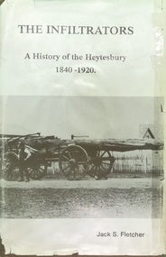 Heytesbury District Historical Society Inc.
Book, The Shire of Heytesbury, The Infiltrators :A History of the Heytesbury 1840-1920 by Jack S. Fletcher, First Edition 1985
The book relates to the triumphs & the achievements, the hardships & the tribulations, of the pioneers & settlers of the district.This book gives a detailed history of the Heytesbury district, including the settlerment of the townships of Port Campbell, Timboon, Princetown. This incorporates the development and establishment of industry, commerce, agriculture, education and social and religious events. Reference to families from the area are listed in index. This book is one of 2 by the author. The other accompanying book is titled "And We Who Followed: A History of the Heytesbury, 1921-1987", and follows "The Infiltrators".A tan hard cover book with title in gold lettering & a dust cover with a photo of a bullock team & wagon carting a large log, with two bullockies driving. The book has a locality map.contents,index,ledger entries & black & white photographschurches, education, agriculture, history, port campbell, pioneers, timboon, cobden, heytesbury, princetown, sports -
 Bendigo Historical Society Inc.
Document - SOUTH NEW MOON MINE - NOTES ON THE SOUTH NEW MOON MINE
Handwritten notes on the South New Moon Mine on the Garden Gully Line of Reef. Notes include locality, depth of shaft, plant, Original Company, New Company, Prominence, Leading Mine, Note and Gold Produced.Notes prepared by Albert Richardson.document, gold, south new moon mine, south new moon mine, garden gully line of reef, sou;th virginia coy, great southern mine, mines dept booklet 'bendigo goldfield' geo brown 1936, mines dept annual and quarterly reports, annals of bendigo mining sections 1890 - 1935, a richardson, booklet 'healthy golden bendigo 1906 public library bendigo -
 Bendigo Historical Society Inc.
Photograph - H. A. & S. R. WILKINSON COLLECTION: BLACK AND WHITE PHOTO OF A MAN
Envelope containing a black and white photo of a man in singlet and shorts standing in front of a fence, few houses and trees in the background. Date and locality unknown. The envelope was between contract of sale 11700.372 and 11700.374. The photo could belong to either of those.organization, business, h.a. & s.r wilkinson real estate -
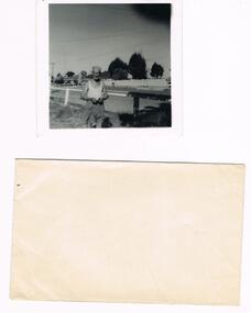
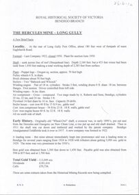 Bendigo Historical Society Inc.
Document - THE HERCULES MINE - NOTES ON THE THE HERCULES MINE
Typed and handwritten notes on the The Hercules Mine at Long Gully. Notes mention locality, when it closed, date of plant auction, depth of shaft, plant, early history, where best gold was obtained, total gold yield, dividends and calls.document, gold, the hercules mine, the hercules mine, notes on the the hercules mine, long gully post office, a roberts & sons, babcock & wilcock, wheal-owl shaft, hercules and energetic, bendigo amalgamated goldfields, historical mining records -
 Bendigo Historical Society Inc.
Document - LITTLE 180 MINE - NOTES ON THE LITTLE 180 MINE
Three handwritten and three typed copies of notes on the Little 180 Mine. Notes include locality, underground connections, depth, plant, historical notes best gold, gold yield and dividends. References are in the left margin. Albert Richardson Collectiondocument, gold, little 180 mine, little 180 mine, notes on the little 180 mine, sheepshead line of reef, john brown factory, central red white & blue, central blue, ironbark south mine, rae's hill, a roberts & sons bendigo, s h johnson stratford, deborah consolidated mine, big 180 mine, new chum syncline mine, george lansell, new chum line of reef, a richardson, bendigo branch of royal historical society, mine's dept transverse and longitudinal sections little 180 mine, catalogue mining sales j h curnow, mine's dept special edition australian mining standard1/6/1899, mines dept booklet bendigo goldfield 1936, mine's dept quarterly and annual reports -
 Bacchus Marsh & District Historical Society
Map, Parish of Yangardook, County of Bourke 1876
The parish of Yangardook lies directly north of the township of Melton. The locality of Toolern Vale lies in the centre of this parish. A single page paper map showing the plan for the Parish of Yangardook in the in the County of Bourke. Scale 40 chains to 1 inch. The map is pasted into a bound volume containing 76 maps or plans in total. High resolution digital image stored on BMDHS computer network. Photo lithographed at the Department of Lands and Survey, Melbourne by J. Noone, 1.8.76yangardook parish maps, toolern vale victoria maps