Showing 99 items
matching locality plans
-
 Ringwood and District Historical Society
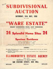
Flyer, Subdivisional Auction Sale Brochure, Ware Estate, East Ringwood, Vic. - 1958
Folded double-sided advertisement for auction of 24 home sites and existing residence on Saturday, 24th May, 1958, including locality map, subdivision layout, terms of sale, and summary of local facilities and services. Additional plan of lots 28-33 dated 26/10/60 by Licensed Surveyor for Kirkpatrick & Webber, 225 Maroondah Highway Ringwood headed Plan of Subdivision of part of Crown Allotment 26A Parish of Ringwood.Subdivision includes Mount Dandenong Road, Ware Crescent, Davey Drive, and Grey Road (later Grey Street). Timber residence included in the subdivision was formerly Ware Kindergarten Holiday Home. (Agent) Ellingworth's Estate Agency, 580 Station Street, Box Hill - (Phone) WX1228. -
 Bacchus Marsh & District Historical Society
Map, Bullengarook Parish, County of Bourke
An undated parish plan map for the parish of Bullegarook. This parish area is close to the Bacchus Marsh district and borders some of the areas contained within the former Bacchus Marsh Shire and present day Moorabool Shire.A single page paper map showing the parish plan map for Bullengarook. This parish area contains the locality of Bullengarook and parts of the Wombat State Forest and is close to the town of Gisborne. A cadastral map showing land ownership. The map is not dated but a very similar map held by the State Library of Victoria is estimated to date from about 1927. The map is pasted into a bound volume containing 76 maps or plans in total. High resolution digital image stored on BMDHS computer network. bullengarook parish maps -
 Bendigo Historical Society Inc.
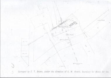
Map - LANSELL'S BIG 180 MINE - LOCALITY OF LANSELL'S NO 180 SHAFT
Buff coloured photocopy of the location of Lansell's No 180 Shaft and showing the positions of Underground Workings near the intersection of Lily St and Alley St. Also mentioned are the North Old Chum Shaft and the New Chum and Victoria Co Shaft. Luffman Brothers has been written in in pen and initialled A R. Printed at the bottom is: Surveyed by E. T. Brown, under the direction of A. W. Howitt, Secretary for Mines for the - (the rest is cut off).map, bendigo, mining plan, lansell's big 180 mine, locality of lansell's no 180 shaft, north old chum co shaft, new chum and victoria co shaft, luffman brothers, e t brown, a w howitt -
 Bendigo Historical Society Inc.
Document - NORTH JOHNSONS MINE - NOTES ON THE NORTH JOHNSONS MINE
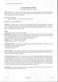
One typed, one handwritten and one handwritten carbon copy of notes on the North Johnsons Mine on the Garden Gully Line of Reef. Notes include size of lease (which was very small, only 83 yards along the line of reef, and the late 1890's absorbed the Rose of Denmark lease, the next mine north, of 57 yeards along the line of reef, Depth of shaft, height of Sill, Locality, Plant, Early History, Prominence, Best Gold, Total Gold Yield and Dividends,Underground Connections and References. Albert Richardson Collection. document, gold, north johnsons mine, north johnsons mine, garden gully line of reef, rose of denmark, camerons reef, dagmar reef, johnsons no 1, johnsons no 2, special edition australian mining standard 1/6/1899, mines dept booklet bendigo goldfield geo brown 1936, mines dept quarterly and annual reports, annals of bendigo mining sections 1866 - 1917, a richardson, e j dunn's special report no 1 measurements taken from north johnsons mine transverse section 22/9/1892, wood & mcnair sharebrokers plan of leases of portion of bendigo goldfield to 4/5/1912 -
 Bendigo Historical Society Inc.
Document - THE SEA GOLD MINING AMALGAMATED COMPANY N. L. - NOTES ON THE SEA GOLD MINING
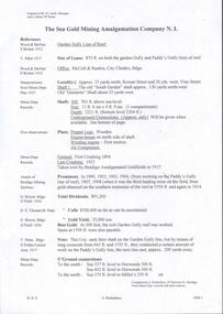
Carbon copy of notes, with typed copy of same, on The Sea Gold Mining Amalgamated Company N. L. on the Garden Gully Line of Reef. Notes include size of lease, office, locality of shaft, sill and depth of shaft, plant, first & last crushing, Prominence, call and dividends, gold yield, best gold and underground connections. Signed by A Richards. Written at the top of page: Original to Mr R Leach, Manager, Allan's Music . Notes prepared by Albert Richardson.document, gold, the sea gold mining amal coy n l, the sea gold mining amalgamated company n. l., notes on the sea gold mining amalgamated company n. l., mccoll & rankin, mines dept plan 1937, annals of bendigo mining sections, g brown bendigo goldfield 1936, wood & mcnair s'brokers 1912, v pabst bendigo goldfields central area 1917, mines dept records, a richardson -
 Bendigo Historical Society Inc.
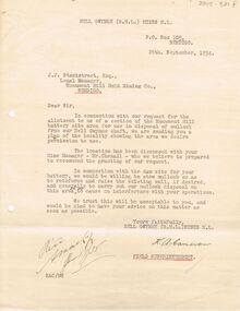
Document - MCCOLL, RANKIN AND STANISTREET COLLECTION: NELL GWYNNE MINES LETTER
... . Mentions raising wall of existing wall of dam. Plan... of dam. Plan of the locality attached. See 2205.846. Document ...Letter to J.J. Stanistreet, Legal Manager, Monument Hill Gold Mining Co., Bendigo from Nell Gwynne Mines N.L., dated 26th September 1934. Letter in connection with our request for the allotment to us of a section of the Monument Hill battery site area for use in disposal of mullock from our Nell Gwynne shaft. Mentions raising wall of existing wall of dam. Plan of the locality attached. See 2205.846.bendigo, business, nell gwynne mines n.l. -
 Wodonga & District Historical Society Inc
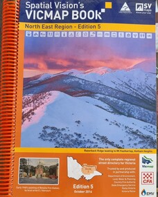
Book - Spatial Vision's VICMAP BOOK 2016 - Northeast Region, Spatial Vision Innovations Pty Ltd, 2016
This edition of Spatial Vision's VicMap Book North East Region was published in October 2016 and provides detailed topographic maps for the region. It was used by emergency services and various agencies, including the Country Fire Authority (CFA). It covers areas including Wodonga, Albury, Wangaratta, and beyond, including national parks and recreation areas. Text on the cover states that the volume is "Trusted by and produced in partnership with: Department of Environment, Land, Water & Planning, Country Fire Authority, State Emergency Service, Parks Victoria, Victoria Police".A spiral bound volume of 409 pages including colour topographic maps and illustrations of North East Victoria. The cover features a colour photo of Razorback Ridge leading to Mount Feathertop, Hotham Heights, Victoria. It also features an index map inside the front cover, a legend, road index, and locality index.This edition of Spatial Vision's VicMap Book North East Region was published in October 2016 and provides detailed topographic maps for the region. It was used by emergency services and various agencies, including the Country Fire Authority (CFA). It covers areas including Wodonga, Albury, Wangaratta, and beyond, including national parks and recreation areas. Text on the cover states that the volume is "Trusted by and produced in partnership with: Department of Environment, Land, Water & Planning, Country Fire Authority, State Emergency Service, Parks Victoria, Victoria Police".emergency management north east victoria, state emergency service, cfa wodonga -
 Wodonga & District Historical Society Inc
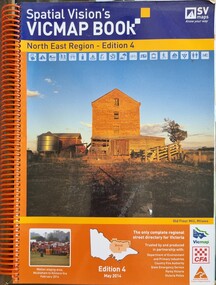
Book - Spatial Vision's VICMAP BOOK 2014 - North East Region
This edition of Spatial Vision's VicMap Book North East Region was published in May 2014 and provides detailed topographic maps for the region. It was used by emergency services and various agencies, including the Country Fire Authority (CFA). It covers areas including Wodonga, Albury, Wangaratta, and beyond, including national parks and recreation areas. Text on the cover states that the volume is "Trusted by and produced in partnership with: Department of Environment, Land, Water & Planning, Country Fire Authority, State Emergency Service, Parks Victoria, Victoria Police".A spiral bound volume of 409 pages including colour topographic maps and illustrations of North East Victoria. The cover features a colour photo of the old flour mill at Milawa, Victoria. It also features an index map inside the front cover, a legend, road index, and locality index.non-fictionThis edition of Spatial Vision's VicMap Book North East Region was published in May 2014 and provides detailed topographic maps for the region. It was used by emergency services and various agencies, including the Country Fire Authority (CFA). It covers areas including Wodonga, Albury, Wangaratta, and beyond, including national parks and recreation areas. Text on the cover states that the volume is "Trusted by and produced in partnership with: Department of Environment, Land, Water & Planning, Country Fire Authority, State Emergency Service, Parks Victoria, Victoria Police".emergency management north east victoria, cfa wodonga