Showing 180 items
matching location of trees
-
 Marysville & District Historical Society
Painting (Item) - Oil painting, Isaac Whitehead, A spring morning near Fernshaw 1880, 1880
A copy of an early oil painting of Fernshaw in Victoria.A copy of an early oil painting of Fernshaw in Victoria by Isaac Whitehead. Isaac Whitehead (1819–1881) was an Irish-Australian artist who worked in watercolour and pastel. He was also a picture framer and art promoter. It is believed that Isaaz Whitehead emigrated to Australia with his family in either 1853 or 1858. Isaac Whitehead died at his home 50 Punt Road, Prahran, Melbourne, on 21 April 1881. Isaac Whitehead had established himself as the foremost picture framer in Melbourne by 1860, known for his highly ornate frames with floral decorations. Among the clients of his framing business were Louis Buvelot, Nicholas Chevalier, and Eugene von Guérard. In his own paintings, he painted a number of scenes of the forests of Gippsland, Victoria. His work focused on the rich landscapes with trees and ferns, with a high degree of botanical detail. His work won him two medals and his work was posthumously exhibited at 1884 Victorian Jubilee Exhibition, the 1886 London Colonial and Indian Exhibition, and the 1888 Melbourne Centennial Intercolonial Exhibition. Fernshaw was a rural township 63 km northeast of Melbourne and 10 km northeast of Healesville. Situated on the Watts River, near where a log had fallen making a convenient crossing, Fernshaw was settled in the 1860s. It provided good country for orchards and berry growing. The location was at the foot of Blacks Spur, with Mounts Juliet and Mondah rising on either side, providing spectacular scenery. There were nearby fern gullies giving rise to the name – ‘shaw’ is old English for thicket or wood. By 1875 Fernshaw had a post office (1865), two hotels, a school (1871), and stores. It was famed for its beauty, attracting tourists. In 1886 the Melbourne and Metropolitan Board of Works began work on the Watts River water catchment scheme – later to become Maroondah – and the Board obtained approval for the catchment country to be reserved and kept free of settlement. This required the removal of the Fernshaw township, which was completed by about 1890.isaac whitehead, fernshaw, victoria, louis buvelot, nicholas chevalier, eugene von guerard, gippsland, victorian jubilee exhibition, london colonial and indian exhibition, melbourne centennial intercolonial exhibition, watts river, healesville, blacks spur, mount juliet, mount mondah -
 Eltham District Historical Society Inc
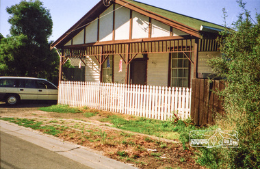
Photograph, Margaret Ball, 72 Franklin Street, Eltham, c.1999, 1999
Owner: Ernie Andrews (potato man). House was shifted to this location.The Margaret Ball (Pre 1960s Houses) Collection was a personal project initiated to mark the year 2000 and arose as a result of the disappearance of many pre-1960s parts of Eltham due to development. Approximately 200 pre-1960s style houses that were left in Eltham between Main Road and east to Bible Street, between Cecil Street to the north and south to Dalton Street were photographed in late 1999. Not all of the houses could be photographed; some because the garden or trees blocked the view of the house, others because of rubbish or cars were in the way, some because people were working on the house or in the gardens at the time.Roll of 35mm colour negative film, 6 stripsAgfa HDC 200 plus-2eltham, houses, streets, margaret ball (pre 1960s houses) collection, franklin street -
 Glen Eira Historical Society
Plan - LEMPRIERE AVENUE
One item about this location 1/Excerpts (5 pages) from Andrew Wards Heritage Study vol 2, 3.6 on Lempriere Avenue and ‘Greenmeadows Gardens’ Historic Area include street plan and general view of Roselle Estate’, Greenmeadows Garden. Included in his description is mention of a large eucalypt in ‘Greenmeadows Gardens’ which pre-dates European settlement.streetscape, lempriere avenue, ‘greenmeadows gardens’, meadow street, alston grove, californian bungalow style, fences, spanish mission style, ‘greenmeadows house, lempriere w. g., meadow street, clarke william senior, ‘greenmeadows’, trees, balaclava road, orrong road, allan road, meadow street, lempriere john, kirton mr, dickson and yorston (pty ltd), lempriere ruby l mrs, dickson g c, yorston j c, st kilda east, east st kilda, roselle estate, east st kilda, east st kilda riding -
 Federation University Historical Collection
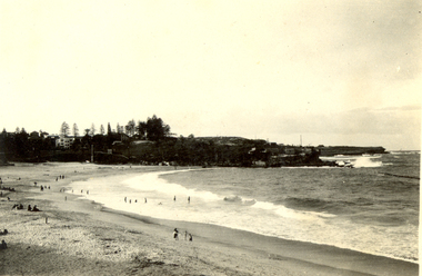
Photograph - Black and White, Frank Wright, Coogee Beach, 1923, Easter 1923
Frank Wright was a renown resident of Smeaton, where he was born. He lived at Laura Villa, and attended Smeaton State School. His father William was a gold miner and his mother's name was Sarah. Their family won many singing and instrumental awards. Frank was tutored by Percy Code and was awarded a gold medal for the highest marks in the ALCM examinations in the British Colonies at the age of seventeen years. He became the Australian Open Cornet Champion by the age of eighteen. A year later, Frank conducted the City of Ballarat Band, and later the Ballarat Soldiers’ Memorial Band. He formed the Frank Wright Frisco Band and Frank Wright and his Coliseum Orchestra. These bands won many South Street awards, and Frank as conductor won many awards in the Australian Band Championship contest. In 1933 Frank Wright sailed to England to conduct the famous St Hilda’s Band and was later appointed Musical Director of the London County Council, where he organized many amazing concerts in parks, in and around the London district. He was made Professor of Brass and Military Band Scoring and conducted at the Guildhall of Music and Drama. Frank was often invited to adjudicate Brass Band Championships around Europe, in Australia, including South Street and in New Zealand. The Frank Wright Medal at the Royal South Street competition is awarded to an individual recognized as making an outstanding contribution to brass music in Australia.Black and white seascape photograph of a beach curving around to a treed headland at end of the beach. The beach is dotted with people both in and out of the water. The location is Coogee, Sydney.Written in pen on back - The surf at Coogee, Sydney. Easter 1923, F.W. (au)frank wright, coogee beach -
 Ringwood and District Historical Society
Map, Plan of Country Lands in the Parishes of Nunawading Ringwood and Scoresby - circa 1855
Blueprint copy of Survey Map detailing original Selectors' names and property locations. List of Parish map references including property bearings, distances in Links, and markings on trees. Descriptive remarks include areas marked "Farmer's Common", "Poor soil thickly/moderately timbered with stringy bark", and location of water and firewood reserves."Surveyed and plotted by N.M. Bickford, Superintendant of Mr. Hodgkinson's Field Party". "The land comprised in this survey is of inferior quality, moderately undulating, and thickly wooded. It is watered by Dandenong Creek and Deep Creek." Inset map showing location of (*proposed) cemetery on southern corner of Lillydale Road from Melbourne and Sawmill Road, later Mount Dandenong Road. (*Cemetery did not eventuate.) -
 Ringwood and District Historical Society
Map, Plan of the Parish of Warrandyte County of Evelyn - 1841
Blueprint copy of Survey Map W27 detailing original Selectors' names and property locations between Yarra Yarra River (Warrandyte) and Mullum Mullum Creek (Ringwood). List of Parish map references including property bearings, distances in Links, and markings on trees. Pound Bend area of Warrandyte marked as Reserve For Aborigines. Descriptive remarks include areas marked "scrubby, flat, sandy soil". Several other references faded and illegible.(Map) by T.H. Nutt Feb 3 1841. -
 Bendigo Historical Society Inc.
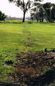
Photograph - CASTLEMAINE GAS COMPANY COLLECTION: PHOTO PADDOCK, 20/07/1999
Photo of a paddock with what looks like the tracing of a trench. Trees in the background. At bottom left date stamp in yellow 20/07/1999. Location unknown.Kodakplace, land, paddock -
 Bendigo Historical Society Inc.
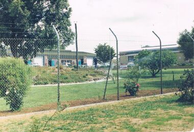
Photograph - CASTLEMAINE GAS COMPANY COLLECTION: PHOTO GARDEN
Garden with shrubs and roses and trees behind a fence and 2 buildings in the background. Date and location unknown.Agfabusiness, retail, gas and fuel -
 Bendigo Historical Society Inc.
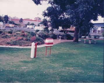
Photograph - CASTLEMAINE GAS COMPANY COLLECTION: PHOTO PARK
Green lawn, park benches and a table, large tree, a red and white box, a post and a red pipe coming out of the ground. In the background a car park with several vehicles and 2 buildings. Date and location unknown.business, retail, gas and fuel -
 Bendigo Historical Society Inc.
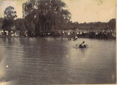
Photograph - PHOTOGRAPH: LAKE WEEROONA BENDIGO
Sepia photograph mounted on board. Image shows large group of people standing on side of lake watching young men paddling in tub like boats. Man in foreground in boat has white skin down to sleeve mark, very tanned arms. Large willow tree in middle, slab fence behind onlookers. Uncertain of location, could be large dam, no buildings evident in background of image.event, recreation, bendigo, recreation, lake, dam. -
 Bendigo Historical Society Inc.
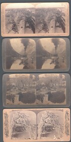
Photograph - WES HARRY COLLECTION: 4 STEREOGRAPHIC CARDS, 1905 ?
Four stereographic cards depicting various scenes and locations : (a) Gudvangen's outlook over the Naerofjord, where the sea reaches far in among the mountains, Norway , (b) Royal Munster Fusiliers fighting from behind the redoubt at Honey Nest Kloof (Feb 16th) South Africa , (c) Winter scene at Niagara Falls , (d) Ancient Olive trees, Garden of Gethsemane, Jerusalem (Mathew xxvi, 36 - 56).place, various, underwood publishers, american series -
 Bendigo Historical Society Inc.
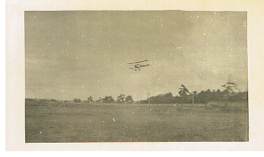
Postcard - BASIL WATSON COLLECTION: POSTCARD BIPLANE FLYING OVER PADDOCK
... Postcard: Biplane flying over paddock, trees on RH side.... Postcard: Biplane flying over paddock, trees on RH side ...Postcard: Biplane flying over paddock, trees on RH side. No location given.aviation, civilian, biplane, basil watson collection, bi-plane. -
 Bendigo Historical Society Inc.
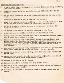
Document - ''PROGRAMME: FOR ABORIGINE CAMP''
''Programme for Aborigine Camp''. Single page typed programme (undated - and no actual location referred to) re 17 activities for a 'demonstration' of how aborigines were supposed to live/have lived? - e.g. #3 One boy to be fishing in the space between the tree at the edge of the creek; # 11 When coach drives through Park, aborigines to rush from all quarters and point their spears at the coach, and jabber. War crys in order.bendigo, history, aboriginal, aboriginal camp. mia mia. -
 Ithacan Historical Society
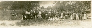
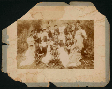
Photograph, Picnic Group, 1920s
From the outset the Ithacan Philanthropic held at least one family picnic a year. They either took place at a popular seaside locations or at popular picnic sites in the nearby hills around Melbourne. The first annual picnic was held in 1918. The Ithacan Greeks worked long hours in family food and restaurant businesses in Melbourne. On Sundays the shops were closed so it was seen as an opportunity to relax outdoors away from the city. The Ithacan Philanthropic Society continues this tradition holding an annual picnic in late summer.A black and white panoramic photograph of a large picnic group of men, women and children standing in an open area with trees around the perimeter. Eight children are sitting on the ground in front of the adults and a group of ladies are sitting on a bench to the left of the group. Some of the party are holding long walking sticks which must have been used when they went on a hike or walk.families, picnics, leisure time. -
 Bendigo Historical Society Inc.
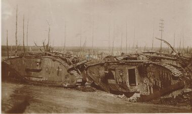
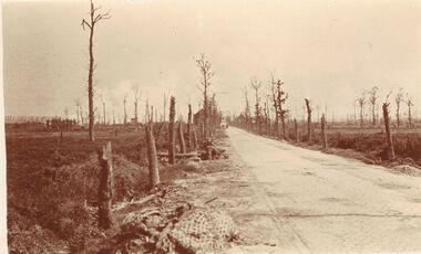
Postcard - ACC LOCK COLLECTION: SEPIA PHOTO OF TWO DESTROYED TANKS, POSTCARD, 1914-1918
... . Defoliated trees in background. Location not known. Handwritten... of two destroyed tanks. Defoliated trees in background. Location ...Postcard, WW1, sepia photo of two destroyed tanks. Defoliated trees in background. Location not known. Handwritten in pencil on the back - G33 and GSpostcard, postcard, ww1, tanks, france -
 Bendigo Historical Society Inc.
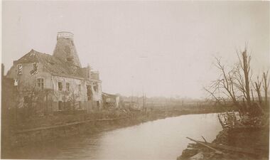
Postcard - ACC LOCK COLLECTION: SEPIA PHOTO OF BOMBED BUILDING BESIDE A RIVER, POSTCARD, 1914-1918
... a river. Other buildings in far distance. Defoliated trees.... Defoliated trees on the right. Location unknown. Handwritten ...Postcard, WW1, Sepia photo of bombed building beside a river. Other buildings in far distance. Defoliated trees on the right. Location unknown. Handwritten in pencil on the back - G43 and GSpostcard, postcard, ww1, france, ruins -
 Bendigo Historical Society Inc.
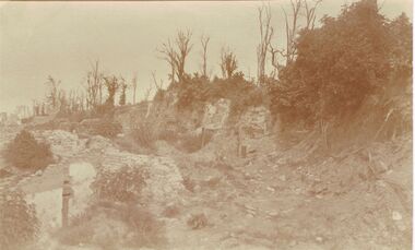
Postcard - ACC LOCK COLLECTION: SEPIA PHOTO OF RUINED BUILDINGS, POSTCARD, 1914-1918
... rubble remains. Shrubs and trees at the side. Location not known... of bombed out buildings, only rubble remains. Shrubs and trees ...Postcard, WW1, sepia photo of bombed out buildings, only rubble remains. Shrubs and trees at the side. Location not knownpostcard, postcard, ww1, france ruins -
 Bendigo Historical Society Inc.
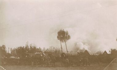
Postcard - ACC LOCK COLLECTION: SEPIA PHOTO OF BATTLEFIELD CAMP, POSTCARD, 1914-1918
... . Two trees in centre. Location unknown G49 and GS handwritten... behind buildings at right. Two trees in centre. Location unknown ...Postcard, WW1, Sepia image of three horse drawn wagons surounded by soldiers. Smoke billowing behind buildings at right. Two trees in centre. Location unknown G49 and GS handwritten in pencil on the reverse.postcard, postcard, ww1, france, battlefield -
 Bendigo Historical Society Inc.
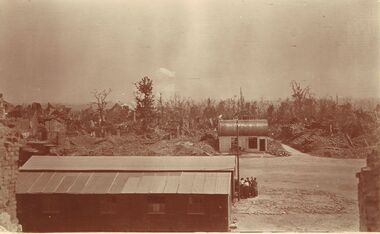
Postcard - ACC LOCK COLLECTION: SEPIA PHOTO OF BATTLEFIELD WITH RAOD AND BUILDINGS, POSTCARD, 1914-1918
Postcard, WW1, Sepia image of a battlefield. Two intact buildings, one on each side of a dirt road. Destroyed buildings in the background amongst trees. A group of six people outside the front building. Location unknown.postcard, postcard, ww1, france, battlefield -
 Bendigo Historical Society Inc.
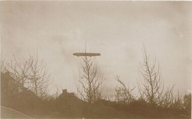
Postcard - ACC LOCK COLLECTION: SEPIA PHOTO OF A ZEPPELIN, POSTCARD, 1914-1918
... houses. Deciduous trees in foreground. Location unknown. G38... of a zeppelin flying over some houses. Deciduous trees in foreground ...Postcard, WW1, sepia photo of a zeppelin flying over some houses. Deciduous trees in foreground. Location unknown. G38 and GS handwritten in pencil on back.postcard, postcard, ww1, france, zeppelin -
 Bendigo Historical Society Inc.
Postcard - ACC LOCK COLLECTION: SEPIA PHOTO OF ROADWAY WITH DEFOLIATED TREES, POSTCARD, 1914-1918
Postcard, WW1, Sepia photo of a roadway with defoliated trees on either side. Rubbish on left side. Two vehicles in the distance. Location not known.postcard, postcard, ww1, france -
 Bendigo Historical Society Inc.
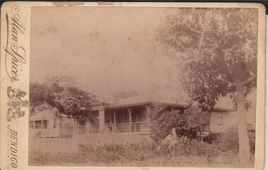
Photograph - ELMA WINSLADE WELLS COLLECTION: PHOTOGRAPH OF TWO HOUSES
Black and white photograph of two houses, a large tree on the right and branches of another one on the left. Date and location unknown. On the left hand side printed the name: Alan Spicer, Bendigo.Alan Spicer, Bendigobuildings, house, unkown -
 Knox Historical Society Inc.
Photograph, Group photo at Fern Tree Gully in 1896, 1896
The photo is of a group of 15 women and 11 men in bush type location with many holding a glass bottle presumably of refreshment. A note on the reverse side indicates that the photo may have been taken on Boxing Day (..."ing Day Fern Tree Gully 1896" but the corner of the photo with the rest of the inscription is missing). The photo is significant as it was taken by George Rose of "The Rose Collection" fame. It was noted on the reverse side was taken at Fern Tree Gully (written the early way as seperate words rather than Ferntree Gully as written today).Group Photo Sepia Fixed to mounting boardSticker affixed to reverse side- Should any copies of this Photograph be required kindly quote number to prevent mistakes.- No. 510 Photographer: Geo. Rose, 123 Chapel Street, Windsor. Inscription: ...ing Day, Fern Tree Gully 1896photo fern tree gully 1896 no.510 -
 Yarra City Council
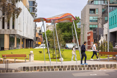
Artwork, other - Installation/Sculpture, William Eicholtz, Close Knit, 2023
'Close Knit' was conceived based around providing the high density accommodation of the area with what many residents will never experience; the iconic ‘Aussie’ backyard, symbolised by washing on a Hills Hoist. This concept was transposed into several elements, including two large flying jumper sculptures. These stainless steel and fibreglass structures are supported on slanted poles, reminiscent of Hills Hoist arms. The jumpers appear to catch the breeze, and billow up, like washing on the clothesline on a sunny day, and cast lovely shadows across the paths and gardens. They are bright and joyful reminders of simple homespun joys. The handcraft theme is also featured in knitted concrete garden walls throughout the gardens. As if the wind is captured in the movement of the Hellenistic drapery, these panels echo the Lady of Justice, an earlier work of mine on the Victorian County Court. These feature walls bring a softness to the park and hark back to classic European garden design. There are 6 finial/balls of wool marking gateways and entrances to the park, as well as a couple randomly scattered throughout to be discovered. There is also a draped plinth at the Peel street entrance which has my signature. Again these elements echo traditional garden design and are a tactile and recognizable link to the hand knit themes of the park. Given the strong themes of domesticity and handcrafts, I have titled my work ‘Close Knit’, as it applies to the purpose of this public space as well as the works scattered throughout. Yarra City Council delivered Cambridge Street Reserve in partnership with the Victorian Government, who have supported the project with $1.3m funding. Yarra City Council has invested a further $731,130 towards the project. Urban Imitative Landscape Design worked with artist William Eicholtz at the beginning of the design process to consider the needs of a growing high-density population of the area. At double the size, with extensive park seating and a large lawn space which is shaded by native trees, Cambridge Street Reserve is now the largest park in Collingwood. 'Close Knit' by William EicholtzTwo knitted fibreglass 'jumpers' over stainless steel framework; six concrete balls of wool throughout the park; 25 metres of cast (drapery) concrete walls; concrete plinth at Peel street entry which is draped with a concrete knit and a ball of wool on top as finial; reverse rope reliefs on the front façade of eastern stairs. Artist name and date 'William Eicholtz 2023' inscribed on plinth with ball of wool on top as finial. handcrafts, domesticity, aussie icons, european garden design, public space, high density accomodation -
 Bendigo Historical Society Inc.
Document - LOCAL TREES - AND OTHERS
Typed notes on some trees planted in Bendigo. The Bunya Pine became popular and to a lesser extent, the Hoop Pine and were planted in people's gardens. Locations of Bunya Pine and some Hoop Pine are listed.document, local trees - and others, fortuna, 'bon acord', wm rae, conroy home, wittscheibe home, mr d shanks, mr & mrs e j howe, alex bain, girton college, joel horwood, dr backhaus, ernst mueller, rosalind park, canterbury park, eaglehawk cemetry, bendigo cemetry, white hills cemetry, kangaroo flat cemetry, r. a. -
Tatura Irrigation & Wartime Camps Museum
Photograph - coloured, Irrigation Research Institute Staff 1985, 1985
Staff photograph of Irrigation Research Institute October 1985Coloured photograph in wooden varnished frame. 73 people. Trees and buildings in background. Peoples names included along base of photograph. Glass cover in frame.Names of people, date and location.irrigation research institute -
Victorian Aboriginal Corporation for Languages
Book, Leon Costermans, Native trees and shrubs of South-eastern Australia, 1998
... of the specific plants and details of their locations and environments ...Coloured photos and detailed line drawings are used to give a very clear description of the specific plants and details of their locations and environments.Colour photographs, illustrations, mapsplants, botany, nsw, victoria, south australia -
Victorian Aboriginal Corporation for Languages
Book, Leon Costermans, Trees of Victoria and adjoining areas, 1994
Format features leaf identification, map of location, seeds and bark etc., in black and white drawings.Colour photographs, illustrations, mapstrees, east gippsland, south coast nsw, mallee -
 Robin Boyd Foundation
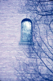
Slide, Robin Boyd
Colour slide in a mount. Shadows of tree on brickwork in winter, unknown locationMade in Australia / Encircled 1A (Handwritten)slide, robin boyd -
 Robin Boyd Foundation
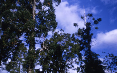
Slide, Robin Boyd, 1967
... Colour slide in a mount. Trees, unknown location... slide in a mount. Trees, unknown location Slide Robin Boyd ...Colour slide in a mount. Trees, unknown locationMade in Australia / 10 / MAY 67M6slide, robin boyd