Showing 1694 items
matching looking south
-
 Ballaarat Mechanics' Institute (BMI Ballarat)
Looking South Drummond St sth 1968 from Hospital
... Looking South Drummond St sth 1968 from Hospital... hospital 1968 Looking South Drummond St sth 1968 from Hospital ...This photograph is from the Max Harris Collection held by the Ballaraat Mechanics' Institute. Please contact BMI for all print and usage inquiries.ballarat, drummond, hospital, 1968 -
 Ballaarat Mechanics' Institute (BMI Ballarat)
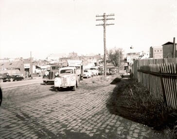
Armstrong St Nth looking south from railway line
... Armstrong St Nth looking south from railway line... nth 1960s Armstrong St Nth looking south from railway line ...This photograph is from the Max Harris Collection held by the Ballaraat Mechanics' Institute. Please contact BMI for all print and usage inquiries. ballarat, armstrong st nth, 1960s -
 Ballaarat Mechanics' Institute (BMI Ballarat)
Armstrong St Nth looking south towards CBD
... Armstrong St Nth looking south towards CBD... nth 1960s Armstrong St Nth looking south towards CBD ...This photograph is from the Max Harris Collection held by the Ballaarat Mechanics' Institute. Please contact BMI for all print and usage inquiries.ballarat, armstrong st nth, 1960s -
 Ballaarat Mechanics' Institute (BMI Ballarat)
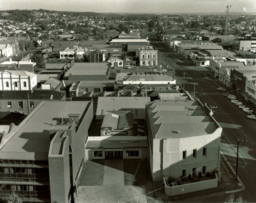
Armstrong St South looking south west from Town Hall tower 1970s
... Armstrong St South looking south west from Town Hall tower... tower 1970s Armstrong St South looking south west from Town Hall ...ballarat, armstrong st, view, above, town hall tower, 1970s -
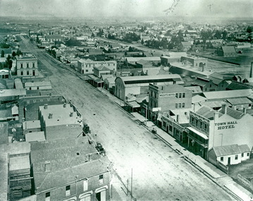 Ballaarat Mechanics' Institute (BMI Ballarat)
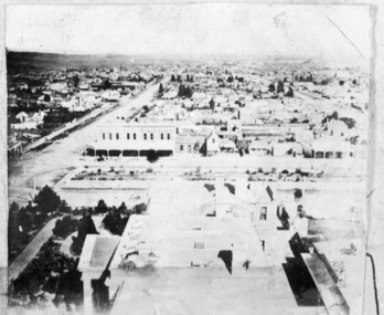
Town Hall Tower Armstrong St Sth looking south 1870s
... Town Hall Tower Armstrong St Sth looking south 1870s... Hall Tower Armstrong St Sth looking south 1870s ...Max Harris Collection, Ballaarat Mechanics' Instituteballarat, armstrong st sth, south, 1870s, town hall hotel -
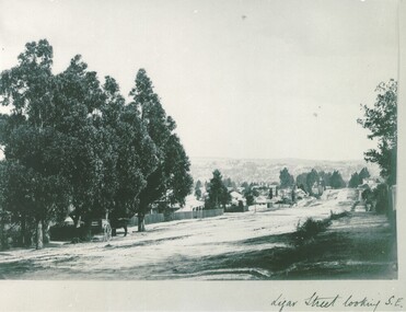 Ballaarat Mechanics' Institute (BMI Ballarat)
Ligar St looking South East
... Ligar St looking South East... looking South East ...This photograph is from the Max Harris Collection held by the Ballaraat Mechanics' Institute. Please contact BMI for all print and usage inquiries.ballarat, ligar -
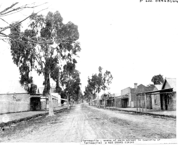 Tarnagulla History Archive
Photograph: Commercial Road, Tarnagulla, looking south from Victoria Theatre
... Photograph: Commercial Road, Tarnagulla, looking south from.... Photograph: Commercial Road, Tarnagulla, looking south from Victoria ...David Gordon Collection. -
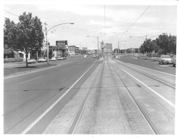 Melbourne Tram Museum
Photograph - St Kilda Road looking south, Melbourne & Metropolitan Tramways Board (MMTB), c1975
... St Kilda Road looking south.... with notes on the rear. Photograph St Kilda Road looking south ...Photograph of the south end of St Kilda Road, before the full reconstruction of High Street St Kilda (now St Kilda Road) but after the reconstruction of the Queens Road underpass, photo c1975. Shows the buildings at the junction including the Tower Hotel in the distance. Signs for advertising include Repco, Caltex Astron, UniRoyal Tyres, and Dunlop Tyres. The "Timeline history of Melbourne Tramways etc Barry George et al" gives the date of the opening of the High St section as March 1975.Yields information about the redevelopment of St Kilda Junction.Black and White Photograph with notes on the rear.On rear of photograph in ink "St Kilda Road Junction Stage One complete c1975"trams, tramways, high st, st kilda junction, st kilda rd -
 Bendigo Historical Society Inc.
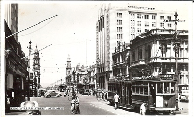
Photograph - BASIL MILLER COLLECTION: KING WILLIAM ST, SOUTH AUSTRALIA - LOOKING SOUTH
... - LOOKING SOUTH... - LOOKING SOUTH ...BHS CollectionBlack and white photo postcard of 3 trams on King William St, Adelaide, SA. The Savings Bank of SA and Penfolds Wines in background. Written on back in black ink, a letter to his mother from Basil Miller.basil miller, bendigo trams -
 Melbourne Tram Museum
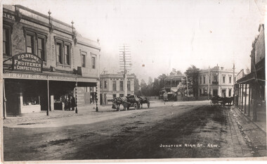
Photograph - Kew Junction looking South West - horse tram, c1900
... Kew Junction looking South West - horse tram... photograph with notes on the rear. Photograph Kew Junction looking ...Photograph, from a postcard titled "Junction High St Kew." shows a horse tram at Kew Junction in Church St about to turn into High St. Buildings in the view are F O Stowe Fruiter Confectioner, Alice cycle works, a tobacconist advertising Havelock tobacco sign, and Collins Kew Hotel. There are three horse-drawn carts, one with a horse eating from a chaff bag.Yields information about Kew Junction c1900.Black and white photograph with notes on the rear.Has on the rear in pencil "Horse tram in Barker Road Kew" and number "185"tramways, horse trams, kew junction, high st kew, church st -
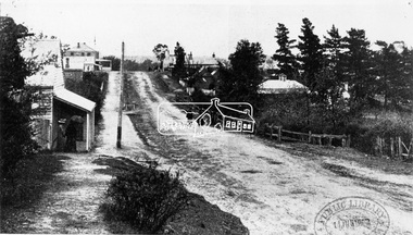
 Ringwood and District Historical Society
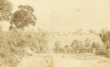
Photograph/Postcard, Warrandyte Road, Ringwood. Looking south towards central Ringwood. 1908. (Postcard + enlarged photos)
... Warrandyte Road, Ringwood. Looking south towards central...Written on back of enlargement, "Warrandyte Rd. Looking..., "Warrandyte Rd. Looking south towards Ringwood.". Written on front ...Written on back of enlargement, "Warrandyte Rd. Looking south towards Ringwood.". Written on front "Railway Township Ringwood" On reverse of postcard: dated 4.12.1908, Addressed to Mrs L. H. Kenney, High St, Preston, Victoria. "Dear Sister, I hope you are all well. We are so but very just now. Love to all. L.K" -
 Greensborough Historical Society
Photograph - Digital image, Frank Robinson, Willows in the Plenty River, looking south west to cliffs, 1954_
... Willows in the Plenty River, looking south west to cliffs....Willows in the Plenty River, looking south west to cliffs..., looking south west to cliffs. The Blackjack property, house ...Willows in the Plenty River, looking south west to cliffs. The Blackjack property, house and acres of fruit orchards ran down to the Plenty River off Hume Street Greensborough and was the home of the Robinson family to late 1956. The photographs were taken as slides by Frank Robinson and digitised by his son James in 2015. Oral history has it that Anthony Beale was the first to bring willow cuttings from the island of St Helena, to Australia.Digital copy of colour photograph.robinson family, blackjack, plenty river -
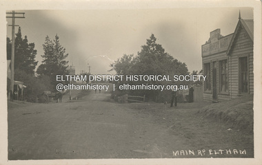
 Eltham District Historical Society Inc
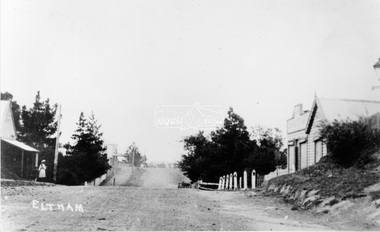
Photograph, View in Eltham looking south along Main road from Bridge Street, 1902
... View in Eltham looking south along Main road from Bridge...Looking south along Main Road from the south side... melbourne Looking south along Main Road from the south side ...Looking south along Main Road from the south side of the intersection of Bridge Street with Main Road. Post Office (Anne Hunniford Postmistress) on left then the Commercial Bank of Australasia building. The house on the right, 'Derril,' was purchased by Walter Gahan in 1924 and was demolished in 1968 when Main Road was widened. In the distance on the left is Watson's Hotel and on the right (opposite side of the main road, Morris's Hotel Cross Ref: 0624This photo forms part of a collection of photographs gathered by the Shire of Eltham for their centenary project book,"Pioneers and Painters: 100 years of the Shire of Eltham" by Alan Marshall (1971). The collection of over 500 images is held in partnership between Eltham District Historical Society and Yarra Plenty Regional Library (Eltham Library) and is now formally known as the 'The Shire of Eltham Pioneers Photograph Collection.' It is significant in being the first community sourced collection representing the places and people of the Shire's first one hundred years.Digital image Print 14 x 24 cm 35 mm B&W negativeanne jane hunniford (1855-1928), bridge street, commercial bank of australia, derril, eltham, gahan house, main road, morris's hotel, post office, shire of eltham pioneers photograph collection, watsons hotel -
 Melbourne Tram Museum
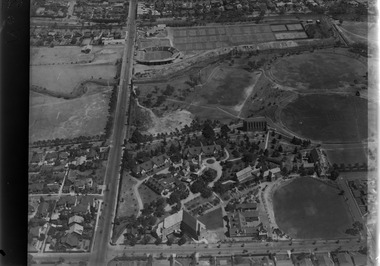
Photograph - Digital Image, Kevin O'Reilly, looking south over the Scotch College complex, Late 1930's to mid 1940's
... looking south over the Scotch College complex... Reg Item 135. Image titled "Scotch" on CD, of looking south..." on CD, of looking south over the eastern part of Scotch College ...Image from CD (Compact Diskette for use in computers) - see Reg Item 135. Image titled "Scotch" on CD, of looking south over the eastern part of Scotch College complex with Glenferrie Road, Hawthorn on the left hand side of the photograph. The Kooyong Stadium (Tennis) constructed in 1927 now shows the new extended Northern stand added in 1934. In the top left of the photograph is the Kooyong Railway Station. A tram can be seen southbound in Glenferrie Road, adjacent to the college. late 1930's to mid 1940's trams, tramways, kooyong, hawthorn, glenferrie rd, kooyong tennis courts, scotch college -
 Melbourne Tram Museum
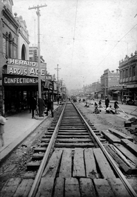
Photograph - Digital Image, Sydney Road, Coburg, looking south from near Bell St, c1920
... Sydney Road, Coburg, looking south from near Bell St...Digital Image of Sydney Road, Coburg, looking south from... Digital Image of Sydney Road, Coburg, looking south from near Bell ...Digital Image of Sydney Road, Coburg, looking south from near Bell St, showing the track repair work to remove bricks from the rails that were resulting in damage to the track foundations by letting water into the track. Photo supplied for identification purposes May 2020, by the Editor, Australian Railway History - see htd4680doc for email correspondence. Image belongs to the ARHS NSW Div. Rail Resource Centre No. 117413 Was used in the June 2020 issue of Australian Railway History - see Reg Item 4684. In the background are the Commercial Bank of Australia, A. M. Hadden Chemist, Walkers Stores, Joblings Boots, a Lending Library with advertisements for "The Age", "The Argus" and "The Herald".trams, tramways, sydney road, coburg, track repairs, trackwork -
 Melbourne Tram Museum
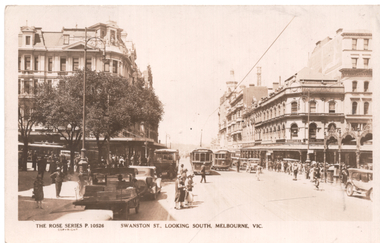
Postcard, Rose Stereograph Co, "Swanston St looking south Melbourne", c1930
... "Swanston St looking south Melbourne"... looking south Melbourne", from just north of Collins Stret. Trams... looking south Melbourne", from just north of Collins Stret. Trams ...Rose Series postcard No. P 10526 titled "Swanston St looking south Melbourne", from just north of Collins Stret. Trams in the view are S class No 164 and W class No 381? On the left side is a cable tram in Collins Street waiting to cross Swanston Street. An early MMTB bus is also heading south in Swanston Street with motorcycle and side car behind it. The cable tram signal is visible just to the left of the bus. This signal would continue to control all tram movements through the intersection until the insulation of modern motor traffic lights around 1929. On the left of photo is the imposing Queen Victoria building demolished in the mid 1960's to make way for the City Square. Yields information about Swanston St. at the intersection with Collins St.Postcard - printed real photograph with Rose Stereograph Co. name on the rear. Unused.trams, tramways, swanston st, s class, tram 164, cable trams, signals, w class, collins st -
 Melbourne Tram Museum
Postcard, Nu-color-Vue, looking south along Swanston St, mid 1970's
... looking south along Swanston St... from the Melbourne Town Hall portico, looking south along... the Melbourne Town Hall portico, looking south along Swanston St towards ...Colour postcard divided back, serrated edge, with a view from the Melbourne Town Hall portico, looking south along Swanston St towards the intersection of Bourke St. shows the city square, Wales Corner, trams and traffic in both streets. Has a W2 crossing Swanston St - W2 586? - the crossing is one of the type which composed of panels that allowed for maintenance. City Square completed to Flinders Lane early 1970, Bourke St Mall opened 1983 - photo mid 1970's Back has space for name and address, stamp and a message and title of postcard. Produced by Nu-Color-Vue. Card Number ML 209, NCV 2940.trams, tramways, postcards, swanston st, bourke st, tram 586? -
 Melbourne Tram Museum
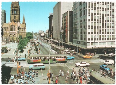
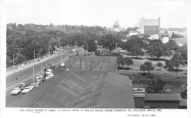
Postcard, Rose Stereograph Co, Flinders St station clock tower looking south towards the Shrine, 1956
... Flinders St station clock tower looking south towards the... the Flinders St station clock tower looking south towards the Shrine... station clock tower looking south towards the Shrine. Shows St ...Postcard - Rose Series black and white of the view from the Flinders St station clock tower looking south towards the Shrine. Shows St Kilda Road, Prince Henry's Hospital, the Yarra River and the gardens on the south side of the river. Has two trams in the view. On the lower edge of the card "The Rose Series P13602 Looking over St Kilda Road from Flinders St Station Melb. Vic" and "Olympic Year 1956". On the rear is a note written to Keith from Ken of Barkly St Mornington on 14/1/58 mainly about a Pat Lyton? now a tram conductor at Hanna St and a meeting with Brian. Has some personal notes about Pat.trams, tramways, flinders st, postcards, st kilda road -
 Eltham District Historical Society Inc
Negative - Photograph, Main Road, Eltham, looking south from Bridge Street, 1906-1907
... Main Road, Eltham, looking south from Bridge Street....Looking south along Main Road from the south side... melbourne Looking south along Main Road from the south side ...Looking south along Main Road from the south side of the intersection of Bridge Street with Main Road. Anne Hunniford's Post Office and Burgoyne's store on left. Miss Harriet (Minnie) Williams's Cash Drapery Mart (est. 1902 and enlarged in 1906), also known as Eltham House on the right. Harriet (Minnie) Williams was born London, 1857, the daughter of George John Williams (1812-1895) and Jane Mansfield (1812-1895). In September 1885 she was operating Williams’s Drapery Establishment in premises on Main Road owned by R. Wallis who advertised them to let in September 1885. In 1902 she opened Williams’s Cash Drapery Mart at the southwest corner of Bridge Street and Main Road (opposite the Post Office), owned by W.J. Taylor. In 1906 she bought the premises and one quarter acre of land and expanded the business with a re-opening in April 1906. Harriet was also well-known and esteemed as an active worker in Methodist circles and also Superintendent of the Sunday School. Harriet fell ill in August 1907 and died 15 August. She is buried in Eltham Cemetery with her good friend Ada Ford. Evelyn Observer and Bourke East Record (Vic. : 1902 - 1917), Friday 30 March 1906, page 5 ________________________________________ ELTHAM. (FROM OUR OWN CORRESPONDENT.) For over three years Miss Williams has carried on a drapery business in very small and inconvenient premises opposite the Eltham post-office. Recently she bought the building and a quarter-acre of land from Mr. W. J. Taylor. Thus having a free hand, she at once matured plans to enlarge and improve the premises to make them suitable for her growing business. The result being that she consulted Mr Roach, contractor, of Heidelberg, put the matter in his hands, and now he has completed in a very satisfactory manner and up-to-date style extensive improvements. A large addition, of very neat and attractive design, with three large windows, has been built right along the front of the old building, and the counters and inside fittings are very neat and convenient, harmonizing well with the attractive outside appearance. Miss Williams has now got in a large now stock of goods, and is making extensive arrangements for a “reopening week," commencing 2nd April, during which time she will make 10 per cent reduction on all cash purchases in the form of gifts of that value. Miss Williams has gone to considerable expense and liability both, in the enlargement and improvement of the premises and in purchasing additional stock. We therefore trust that the public will stand by her by heartily and en masse patronizing her re-opening effort to show their appreciation of pluck in this advance movement. Google Street View Feb 2017: https://www.google.com.au/maps/@-37.7191341,145.1462046,3a,50.5y,191.91h,88.27t/data=!3m6!1e1!3m4!1sARwwqEQfMSfH9oTWWapPgQ!2e0!7i13312!8i6656This photo forms part of a collection of photographs gathered by the Shire of Eltham for their centenary project book,"Pioneers and Painters: 100 years of the Shire of Eltham" by Alan Marshall (1971). The collection of over 500 images is held in partnership between Eltham District Historical Society and Yarra Plenty Regional Library (Eltham Library) and is now formally known as the 'The Shire of Eltham Pioneers Photograph Collection.' It is significant in being the first community sourced collection representing the places and people of the Shire's first one hundred years.Digital image 4 x 5 inch B&W Negsepp, shire of eltham pioneers photograph collection, eltham, main road, anne jane hunniford, burgoyne store, christopher watson, commercial bank of australia, drapery store, eltham house, harriet (minnie) williams, post office, watson's hotel, williams's cash drapery mart -
 Eltham District Historical Society Inc
Negative - Photograph, Main Road, Eltham, looking south from Bridge Street, 1906-1907
... Main Road, Eltham, looking south from Bridge Street....Looking south along Main Road from the south side... melbourne Looking south along Main Road from the south side ...Looking south along Main Road from the south side of the intersection of Bridge Street with Main Road. Anne Hunniford's Post Office and Burgoyne's store on left. Miss Harriet (Minnie) Williams's Cash Drapery Mart (est. 1902 and enlarged in 1906), also known as Eltham House on the right. Harriet (Minnie) Williams was born London, 1857, the daughter of George John Williams (1812-1895) and Jane Mansfield (1812-1895). In September 1885 she was operating Williams’s Drapery Establishment in premises on Main Road owned by R. Wallis who advertised them to let in September 1885. In 1902 she opened Williams’s Cash Drapery Mart at the southwest corner of Bridge Street and Main Road (opposite the Post Office), owned by W.J. Taylor. In 1906 she bought the premises and one quarter acre of land and expanded the business with a re-opening in April 1906. Harriet was also well-known and esteemed as an active worker in Methodist circles and also Superintendent of the Sunday School. Harriet fell ill in August 1907 and died 15 August. She is buried in Eltham Cemetery with her good friend Ada Ford. Note also the gas street lamp on right. Watson's Hotel on corner of Pitt Street visible in distance. The CBA bank building is hidden behind trees, the chimney and part roof visible. The photo was possibly taken by John Henry Clark of Clark Bros Photographers who operated from 25 Thompson Street, Windsor near Prahan 1894-1914. Evelyn Observer and Bourke East Record (Vic. : 1902 - 1917), Friday 30 March 1906, page 5 ________________________________________ ELTHAM. (FROM OUR OWN CORRESPONDENT.) For over three years Miss Williams has carried on a drapery business in very small and inconvenient premises opposite the Eltham post-office. Recently she bought the building and a quarter-acre of land from Mr. W. J. Taylor. Thus having a free hand, she at once matured plans to enlarge and improve the premises to make them suitable for her growing business. The result being that she consulted Mr Roach, contractor, of Heidelberg, put the matter in his hands, and now he has completed in a very satisfactory manner and up-to-date style extensive improvements. A large addition, of very neat and attractive design, with three large windows, has been built right along the front of the old building, and the counters and inside fittings are very neat and convenient, harmonizing well with the attractive outside appearance. Miss Williams has now got in a large now stock of goods, and is making extensive arrangements for a “reopening week," commencing 2nd April, during which time she will make 10 per cent reduction on all cash purchases in the form of gifts of that value. Miss Williams has gone to considerable expense and liability both, in the enlargement and improvement of the premises and in purchasing additional stock. We therefore trust that the public will stand by her by heartily and en masse patronizing her re-opening effort to show their appreciation of pluck in this advance movement. Google Street View Feb 2017: https://www.google.com.au/maps/@-37.7191341,145.1462046,3a,50.5y,191.91h,88.27t/data=!3m6!1e1!3m4!1sARwwqEQfMSfH9oTWWapPgQ!2e0!7i13312!8i6656 This photo forms part of a collection of photographs gathered by the Shire of Eltham for their centenary project book,"Pioneers and Painters: 100 years of the Shire of Eltham" by Alan Marshall (1971). The collection of over 500 images is held in partnership between Eltham District Historical Society and Yarra Plenty Regional Library (Eltham Library) and is now formally known as the 'The Shire of Eltham Pioneers Photograph Collection.' It is significant in being the first community sourced collection representing the places and people of the Shire's first one hundred years.Digital image (x2) 4 x 5 inch B&W Neg B&W Print 16 x 25 cmsepp, shire of eltham pioneers photograph collection, eltham, main road, anne jane hunniford, burgoyne store, christopher watson, commercial bank of australia, drapery store, eltham house, gas lamp, harriet (minnie) williams, post office, street lamp, watson's hotel, williams's cash drapery mart, clark bros. photo -
 Eltham District Historical Society Inc
Photograph, Main Road, Eltham, looking south from Bridge Street, c.1906-1907
... Main Road, Eltham, looking south from Bridge Street.... birthday. With love from Mary & Ada" See also SEPP_0624 Looking... collection Main Road, Eltham, looking south from Bridge Street ...Birthday greetings sent by Mary and Ada Shillinglaw from their home, 'Wattle Brae' at Eltham to their sister Carrie (Watson). Carrie was born 29 Feb 1876. Whilst the postcard was dated 1917, the actual photo is dated between 1906 and 1907. ""Wattle Brae" Eltham 28/2/17 Dear Carrie Wishing you a Bright and a happy birthday. With love from Mary & Ada" See also SEPP_0624 Looking south along Main Road from the south side of the intersection of Bridge Street with Main Road. Anne Hunniford's Post Office and Burgoyne's store on left. Miss Harriet (Minnie) Williams's Cash Drapery Mart (est. 1902 and enlarged in 1906), also known as Eltham House on the right. Harriet (Minnie) Williams was born London, 1857, the daughter of George John Williams (1812-1895) and Jane Mansfield (1812-1895). In September 1885 she was operating Williams’s Drapery Establishment in premises on Main Road owned by R. Wallis who advertised them to let in September 1885. In 1902 she opened Williams’s Cash Drapery Mart at the southwest corner of Bridge Street and Main Road (opposite the Post Office), owned by W.J. Taylor. In 1906 she bought the premises and one quarter acre of land and expanded the business with a re-opening in April 1906. Harriet was also well-known and esteemed as an active worker in Methodist circles and also Superintendent of the Sunday School. Harriet fell ill in August 1907 and died 15 August. She is buried in Eltham Cemetery with her good friend Ada Ford. Evelyn Observer and Bourke East Record (Vic. : 1902 - 1917), Friday 30 March 1906, page 5 ________________________________________ ELTHAM. (FROM OUR OWN CORRESPONDENT.) For over three years Miss Williams has carried on a drapery business in very small and inconvenient premises opposite the Eltham post-office. Recently she bought the building and a quarter-acre of land from Mr. W. J. Taylor. Thus having a free hand, she at once matured plans to enlarge and improve the premises to make them suitable for her growing business. The result being that she consulted Mr Roach, contractor, of Heidelberg, put the matter in his hands, and now he has completed in a very satisfactory manner and up-to-date style extensive improvements. A large addition, of very neat and attractive design, with three large windows, has been built right along the front of the old building, and the counters and inside fittings are very neat and convenient, harmonizing well with the attractive outside appearance. Miss Williams has now got in a large now stock of goods, and is making extensive arrangements for a “reopening week," commencing 2nd April, during which time she will make 10 per cent reduction on all cash purchases in the form of gifts of that value. Miss Williams has gone to considerable expense and liability both, in the enlargement and improvement of the premises and in purchasing additional stock. We therefore trust that the public will stand by her by heartily and en masse patronizing her re-opening effort to show their appreciation of pluck in this advance movement. Google Street View Feb 2017: https://www.google.com.au/maps/@-37.7191341,145.1462046,3a,50.5y,191.91h,88.27t/data=!3m6!1e1!3m4!1sARwwqEQfMSfH9oTWWapPgQ!2e0!7i13312!8i6656 POSTCARD 1905-1940s Like the carte-de-visite, postcards enjoyed a collecting craze by large numbers of people, and were often kept in albums through which the interested visitor could browse. Postcards were posted or exchanged in huge numbers. Postal authorities in Australia only allowed the private printing of postcards from 1898. At this time the back of the card was reserved for the address and postage stamp, and the front was used for the message and a picture. In 1902 British authorities allowed a "divided back", so that the left side could be used for the message, the right side for the address and stamp, and the whole of the front was devoted to the picture. France followed suit in 1904, Germany and Australia in 1905, and the United States in 1907. - Frost, Lenore; Dating Family Photos 1850-1920; Valiant Press Pty. Ltd., Berwick, Victoria 1991marg ball collection, postcard, 1906, 1917, ada maria chrisfield (nee shillinglaw) 1889-1974, ada maria shillinglaw (1889-1974), caroline (carrie) watson (nee shillinglaw 1876-1956), cash drapery mart, eltham, eltham hotel, main road, mary ann shillinglaw (1880-1963), shillinglaw cottage, watsons hotel, wattle brae -
 Glenelg Shire Council Cultural Collection
Photograph - Photograph - Blacknose Quarry, 29/09/1952
... , looking south...Front: 'BLACKNOSE QUARRY ACCESS ROAD 25.9.52 LOOKING SOUTH...: 'BLACKNOSE QUARRY ACCESS ROAD 25.9.52 LOOKING SOUTH ' - printed ...Port of Portland Authority ArchivesFront: 'BLACKNOSE QUARRY ACCESS ROAD 25.9.52 LOOKING SOUTH ' - printed on bottom frame Back: Purple PHT stampport of portland archives, blacknose quarry -
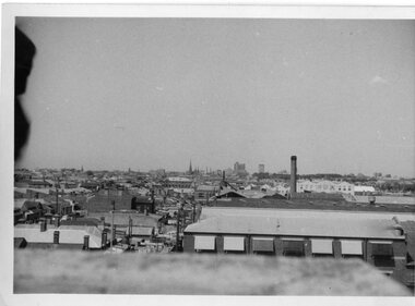 Melbourne Tram Museum
Photograph - Black and White photograph, Melbourne & Metropolitan Tramways Board (MMTB), 11/11/1963 12:00:00 AM
... Black and white photograph of a view looking south over...On the rear in ink "Nth Fitzroy Depot, 11-11-63 looking... Fitzroy Depot, 11-11-63 looking south" Black and white photograph ...Black and white photograph of a view looking south over North Fitzroy Depot towards the city, dated 11-11-63On the rear in ink "Nth Fitzroy Depot, 11-11-63 looking south"trams, tramways, north fitzroy, melbourne -
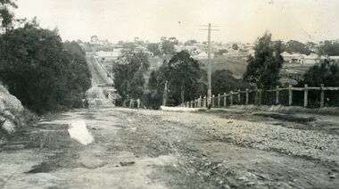 Ringwood and District Historical Society
Photograph, Looking south down Warrandyte Road, Ringwood around 1920
... Looking south down Warrandyte Road, Ringwood around 1920... Road. Looking south down Warrandyte Road, Ringwood around 1920 ...Black and white photograph taken just below where Mullum Mullum Road meets Warrandyte Road.The Mullum Mullum Bridge can be seen in the dip, with numerous houses on the ridge on Whitehorse Road (Maroondah Highway). The fencing was post and rail, with Warrandyte Road unmade, sealed with crushed rocks. -
 Ringwood and District Historical Society
Photograph, Looking south up Werac Drive, North Ringwood past Manuelo Drive in February 1979
... Looking south up Werac Drive, North Ringwood past Manuelo... Clarke collection. Looking south up Werac Drive, North Ringwood ...E552 N21 Part of a 51-photo record of the development of the "Kubis" Estate, Ringwood North, including road works to Debbie Place, Kubis Drive, Werac Drive, Manuelo Drive, Iluka Place and Glenvale Road. From the Jack Lundy Clarke collection. -
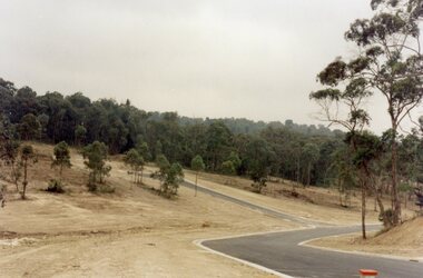 Ringwood and District Historical Society
Photograph, Junction of Kubis Drive and Iluka Court, North Ringwood, in February 1979. Looking south with Hubbard Reserve beyond
... February 1979. Looking south with Hubbard Reserve beyond.... Ringwood, in February 1979. Looking south with Hubbard Reserve ...E552 N25 Part of a 51-photo record of the development of the "Kubis" Estate, Ringwood North, including road works to Debbie Place, Kubis Drive, Werac Drive, Manuelo Drive, Iluka Place and Glenvale Road. From the Jack Lundy Clarke collection. -
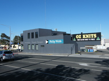 Ringwood and District Historical Society
Photograph, 135 Maroondah Highway, looking south-west across Ringwood Street intersection, in 2008. Showing Philip Webb real estate, formerly the SEC
... 135 Maroondah Highway, looking south-west across Ringwood... Haines, RDHS, in 2008. 135 Maroondah Highway, looking south-west ...Photographic record by Russ Haines, RDHS, in 2008. -
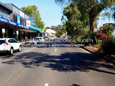 Eltham District Historical Society Inc
Photograph - Digital Photograph, Jim Connor, Main Road, Eltham looking south towards Arthur Street, 18 April 2018
... Main Road, Eltham looking south towards Arthur Street... Thompson's Pharmacy 1 image - born digital Main Road, Eltham looking ...jim connor collection, eltham shopping centre, main road, thompson's pharmacy -
 Eltham District Historical Society Inc
Photograph, Looking south towards Nyora Road, Eltham, 1977, 1977
... Looking south towards Nyora Road, Eltham, 1977.... Looking south towards Nyora Road, Eltham, 1977 Photograph ...Viewed from near the end of Stokes Place where the linear reserve now runs between 8 and 9 Stokes Place just visible through trees in foreground, 24 Nyora with red roof is the first house in middle of view. Frank Stokes first traveled to the district by train in 1944 to find land with the intention to establish an orchard. By chance he met Arthur Bird of Bird Orchard (bounded by Pitt Street, Eucalyptus Road and Wattle Grove) and they got talking over their common interest. Arthur put Frank up for the night and pointed out the land, part of Crown Allotment 15, Section 5, Parish of Nillumbik (CA15) somewhat diagonally opposite Bird Orchard. Frank bought the land and for the next two years would travel by train from Melbourne to Eltham every weekend establishing Stokes Orchard and building a home for his family, which they eventually moved into in 1946. In the mid 1970s the Shire of Eltham divided the orchard up into numerous rate-able parcel lots, which became affordable for Frank. As a consequence Stokes Orchard was turned into a housing development by Macquarie Builders and marketed as the Stokes Orchard Estate in two stages; Stage 1 encompassing Scarlet Ash Court, Ironbark Close and Peppermint Grove bounded by Nyora and Eucalyptus roads c.1976 and Stage 2 encompassing Stokes Place, Orchard Way, The Crest and The Lookout bound by Nyora and Diosma roads c.1979. The development of Orchard Way, The Crest and The Lookout did not proceed as planned due to the lack of the sewer along Diosma Road and so many of the proposed lots were incorporated into five-acre parcels instead.Housing development in Eltham as an extension to the Woodridge EstateDigital file only - Digitised by EDHS from a scrapbook (containing commercially printed photos of digital scans) on loan from Beryl Bradbury (nee Stokes), daughter of Frank Stokes.1977, beryl bradbury (nee stokes) collection, nyora road, stokes orchard estate, stokes place -
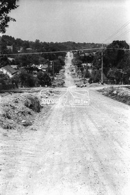 Eltham District Historical Society Inc
Photograph, Looking south towards intersection of York Street near 70 Bible Street, Eltham, c.September 1966, 1966c
... Looking south towards intersection of York Street near 70... Looking south towards intersection of York Street near 70 Bible ...Black and white photographic printOriginally located in a Filmpro King Size Prints processing envelope $3.01 Shire of Eltham 9/9/66 and noted as Calrossie Ave area and crossed out Eltham-Yarra Glen Road, Bridge Street to Elsa Court existing conditions mid 1967bible street, road construction, streets, york street