Showing 102 items
matching lower lake
-
 Stawell Historical Society Inc
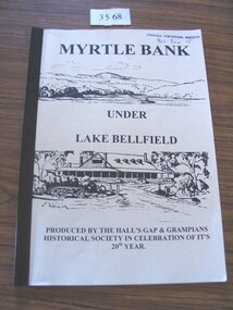
Book, Ida Stanton, Myrtlebank under Lake Bellfield, 2003
THe history of Myrtle bank, Halls gap and the GrampiansPale yellow card covers with plastic binding. drawing of a lake with a small boat and a man fishing. lower drawing two buildings one with four chimneys, and a wagon out the front.Myrtle Bank Under Lake Bellfield Produced by the Halls Gap & Grampians Historical society in celebration of it's 20th Year.stawell grampians -
 Bendigo Historical Society Inc.
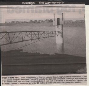
Newspaper - JENNY FOLEY COLLECTION: WHEN IT WAS FULL
BHS CollectionBendigo advertiser ''The way we were'' from 2003. When it was full: Brian Hollingworth of Epsom, supplied this photograph of the construction of the tower access bridge at lake Eppalock in 1962, just after the dam was completed. The bridge, which reaches to the intake tower, took about two months to build. It was built on the bank in sections and lowered into the water. The end of the bridge lay under 20 metres of water until lifted and placed into position. The clip is in a folder.newspaper, bendigo advertiser, the way we were -
 Lakes Entrance Historical Society
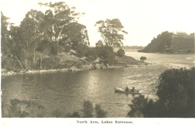
Postcard - North Arm Lakes Entrance Victoria. c1930, 1930 c
two people in a rowing boat on the lower reaches of the North Arm looking downstream Lakes Entrance Victoria. c1930 Second black and white postcard of lower reaches of North Arm looking upstream Lakes Entrance 04324.1, 9 x 14 cmBlack and white postcard showing two people in a rowing boat on the lower reaches of the North Arm looking downstream Lakes Entrance Victoria c1930. Second black and white postcard of lower reaches of North Arm looking upstream Lakes EntranceNorth Arm Lakes Entrancewaterways, topography, vegetation -
 Flagstaff Hill Maritime Museum and Village
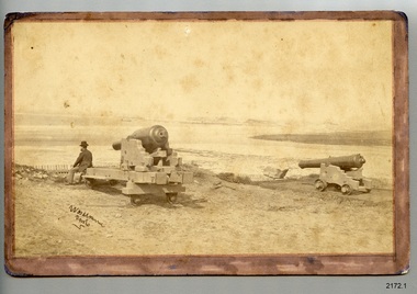
Photograph - Historical, maritime, 1878
The location of this photograph is disputed by historians, but the consensus is that is shows the early use of Flagstaff Hill by the Warrnambool Garrison. This photograph is very similar to one on file in the State Library of Victoria (SLV). The photograph in the State Library's collection is clearer, and is in black and white. It also has an inscription below it "Lady Bay, Warrnambool, 1878'. The inscription on the lower left of the SLV's photograph looks to be the same as on Flagstaff Hill's copy. The photographer is unidentified. The photograph is significant to Warrnambool's local history. It is connected to the 1870's defence of the Port of Warrnambool, and to southwest Victoria's coast. The photograph can be used as a comparative tool for measuring the changes in the landscape and the harbour.Photograph, sepia, on card. Unknown photographer. View towards Lady Bay, Warrnambool. A gentleman is seated on one of two cannon carriages with cannon, on a hill above a picket fence. A moored sailing ship is in the bay. Hills are in the background and la building is on land to the right. The photograph is mounted on card with a brown, hand coloured border on the front. The corners on the card are rounded. the reverse has round marks in the corners indicating that the photograph has been previously mounted, perhaps in an album. There is a purple stamp and some pencil inscriptions. A handwritten pen inscription is on the lower left corner of the front. [(1b) This black and white photograph is a copy of the original and has been printed on larger paper.]Front: "[undecipherable] / photo" Reverse in pencil: " REG. NO. 2172.1 / ORIGINAL" Reverse, stamped: "Flagstaff Hill Maritime Village"flagstaff hill, warrnambool, shipwrecked-coast, flagstaff-hill, flagstaff-hill-maritime-museum, maritime-museum, shipwreck-coast, flagstaff-hill-maritime-village, photograph, warrnambool, lady bay, lake pertobe, cannon hill, middle island, steam ship, breakwater, cannon, victoria, man seated on cannon, 1878, militia fort, port of warrnambool, militia, garrison, warrnambool garrison -
 Lakes Entrance Historical Society
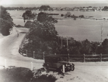
Photograph - Princes Highway around Jemmys Point, Lakes Entrance, H D Bulmer, 1930 c
Princes Highway around Jemmys Point, car parked on road at junction of original steep road to top of Jemmys Point. Man on bicycle riding up hill. Bullock Island and New Works in distance over North Arm and Cunninghame Arm waterways Lakes Entrance VictoriaBlack and white photograph of lower section of Princes Highway around Jemmys Point, car parked on road at junction of original steep road to top of Jemmys Point. Man on bicycle riding up hill. Bullock Island and New Works in distance over North Arm and Cunninghame Arm waterways Lakes Entrance Victoriaroads and streets, township, waterways, fences, vehicles -
 Lakes Entrance Historical Society
Photograph - Bullock Island Lakes Entrance, M Holding, 1988 c
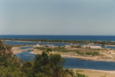
Kalimna Heights showing development on Bullock Island including Pecks Factory. The Club Spit of dredged sand is acquiring vegetation. April Hamer dredge moored at Port Jetty, new bridge in place Lakes Entrance VictoriaAlso two colour photographs showing dumped sand on Bullock Island taken from Princes Highway lower parking bay June 2000. Donor L P Newspaper number 04209.1 size 10 x 15 cm and 04209.2 size 10 x 15 cm|Two colour photographs of Gippsland Ports Facilities taken from waterway numbers 04208.3 and 04208.4 size 10 x 15 cmColour photograph taken from Kalimna Heights showing development on Bullock Island including Pecks Factory. The Club Spit of dredged sand is acquiring vegetation. April Hamer dredge moored at Port Jetty, new bridge in place Lakes Entrance Victoriaislands, waterways, gippsland lakes -
 Lakes Entrance Historical Society
Postcard - North Arm bridge Lakes Entrance Victoria, Bulmer H D, 1950c
3 Identical small format postcards 9 x 14Black and white small format postcard showing the town, North Arm bridge, Cunninghame Arm, sand hummocks, boat harbour, tourist launch approaching North Arm, power poles on lower side of road cutting. Lakes Entrance VictoriaLakes Entrance from Jemmys Pointbridges, township -
 Lakes Entrance Historical Society
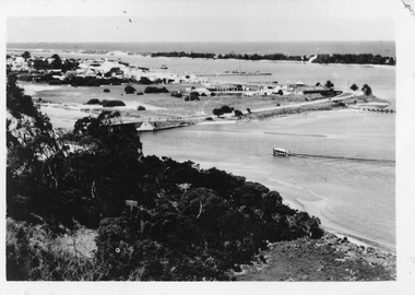
Photograph - View from Jemmys Point, 1926
Also two other black and white photographs taken along the road to Jemmys Point Bullock Island in background 05002.1 and 05002.2 showing trees along roadside 7 x 11.5 cmBlack and white photograph looking uphill at Jemmys Point Road showing post and rail fence on lower side and steep roadside cutting on upper side Lakes Entrance Victoria waterways, roads and streets, islands -
 Stawell Historical Society Inc
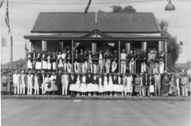
Photograph, Stawell Lawn Bowling Club Season Opening Day c1950's or 1960's
Stawell Bowling Club Season Opening Day. Large group of people on verandah of two storey Club house building with a line of people at lower level. Sometime in late 1950'sor early 1960's. Shows willow trees around Cato lake in background.stawell sport -
 Lakes Entrance Historical Society
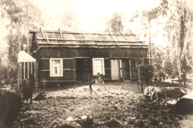
Photograph - Northropes Bunga Haven Lake Bunga Victoria, H D Bulmer, 1904 c
Sepia toned photograph of a bark house in bushland with glazed sash windows of six panes upper and lower. Large chimney of dropped slabs held in place by narrow uprights. Known as Northropes Bunga Haven Lake Bunga Victoriabuildings, settlers -
 Lakes Entrance Historical Society
Postcard - Reeves Channel, 1910 c
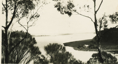
Black and white postcard showing view of Reeves channel looking west toward Metung west end of Rigby and Fraser Islands mouth of Maringa creek lower right with neat mill workers cottages on flat Lakes Entrance Victoriawaterways -
 Lakes Entrance Historical Society
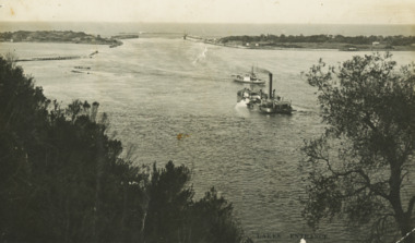
Postcard - Dredge Pioneer, Segerberg and Bulmer, 1910 c
Message on back Arrived safe 25th have a good time hoping you are well from FCG Addressed to Mrs FC Gason, Jessops Hill, Lower NicholsonBlack and white postcard showing dredge Pioneer working below Jemmys Point facing entrance rock groynes on west of Bullock Island calm entrance in distance steamer JCD heading across Reeves Channel after leaving Lakes Entrance VictoriaLakes Entrance waterways, dredges, correspondence