Showing 370 items
matching lower park greensborough
-
 Greensborough Historical Society
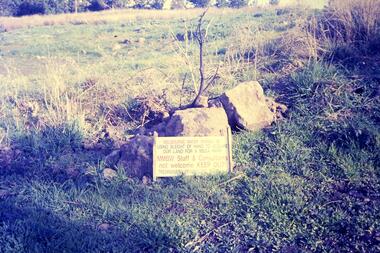
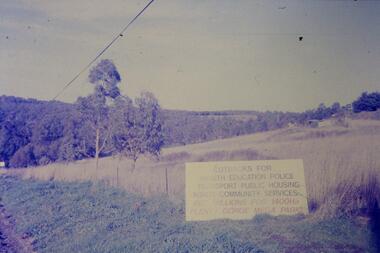
Slide - Photograph, John Ramsdale, Plenty Gorge sign: Slide 50, 1990s
Photograph shows a sign accusing MMBW of taking land for mega park - Plenty Gorge ParkPart of the John Ramsdale collection of slides and audio visual material.Colour photograph scanned from slide.No maker's marks. No caption on slide.plenty gorge metropolitan park, plenty gorge, melbourne and metropolitan board of works -
 Greensborough Historical Society
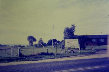
Slide - Photograph, John Ramsdale, Gorge Road sign: Slide 55, 1990s
Photograph shows house with anti-Plenty Gorge Park sign, Gorge Road South MorangPart of the John Ramsdale collection of slides and audio visual material.Colour photograph scanned from slide.No maker's marks. No caption on slide.plenty gorge, plenty gorge metropolitan park, melbourne and metropolitan board of works -
 Greensborough Historical Society
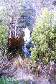
Slide - Photograph, John Ramsdale, Plenty Gorge: Slide 59, 1990s
Photograph shows a river through bushland. This is in Plenty Gorge.Part of the John Ramsdale collection of slides and audio visual material.Colour photograph scanned from slide.No maker's marks. No caption on slide.plenty gorge, plenty gorge metropolitan park -
 Greensborough Historical Society
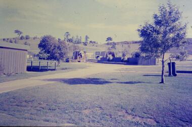
Slide - Photograph, John Ramsdale, Park and kiosk, Whittlesea: Slide 63, 1990s
Photograph shows farm park and kiosk on Plenty Road Whittlesea. This is the future site of Funfields.Part of the John Ramsdale collection of slides and audio visual material.Colour photograph scanned from slide.No maker's marks. No caption on slide.funfields, plenty road whittlesea -
 Greensborough Historical Society
Slide - Photograph, John Ramsdale, Sign - Gorge Road: Slide 76, 1990s
Photograph shows an anti- Plenty Gorge Park sign in Gorge Road South MorangPart of the John Ramsdale collection of slides and audio visual material.Colour photograph scanned from slide.No maker's marks. No caption on slide.plenty gorge, plenty gorge metropolitan park, melbourne and metropolitan board of works -
 Greensborough Historical Society
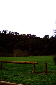
Slide - Photograph, John Ramsdale, Sports fields at Whatmough Park: Slide 78, 1990s
Photograph shows a park with pole fence in foreground. Part of the sports fields at Whatmough Park Greensborough.Part of the John Ramsdale collection of slides and audio visual material.Colour photograph scanned from slide.No maker's marks. No caption on slide.whatmough park, sports fields -
 Greensborough Historical Society
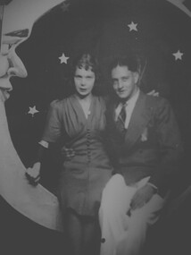
Photograph - Digital Image, Winifred O'Neill and Alfred Gibson 1934, 1934_
"My parents Winifred (O'Neill daughter of Ivy and Frank O'Neill) and Alfred Gibson. Courting days approx 1934 Luna Park." - Vicki WilsonDigital copy of black and white photographoneill family, winifred o'neill, clayton family, alfred gibson -
 Greensborough Historical Society
Photograph - Digital Image, Anne Paul, Cherry Street Macleod - Avenue of Honour, 26/06/2019
Photographs of the Avenue of Honour in Cherry Street Macleod. Established in 1919 as a memorial to service men and women who gave their lives in World War 1, the Avenue is a single row of sugar gums, the former Mont Park hospital grounds are adjacent. These photographs show the plaque. Digital copy of 3 colour photographs.macleod avenue of honour, cherry street macleod -
 Greensborough Historical Society
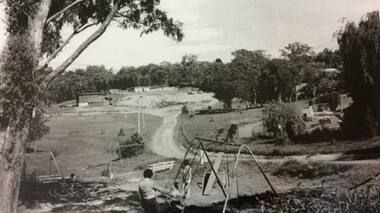
Photograph - Digital image, Ian Gilbert, Petrie Park 1960s, 1960s
Petrie Park Montmorency in the 1960s. The long drive can be seen with some children's play equipment. Today the park has a sports oval for cricket and football, a tennis court and lawn bowls as well as a children's playground. It is also the home of the Montmorency – Eltham RSL. The park is situated on Mountainview Road.Digital copy of black and white photo.petrie park montmorency, mountainview road montmorency -
 Greensborough Historical Society
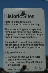
Photograph - Digital Image, Mernda historic sites 2018, 25/07/2019
In 2018 GHS members visited Turner's Bakery in Mernda for lunch and continued on to visit historic sites remaining in the Mernda area. These photographs show remnant bush and the Parks Victoria sign in the area.Mernda is an area of rapid modern growth with a few remaining historic buildings dating from the 19th centuryDigital copy of colour photographsmernda, parks victoria, bushland -
 Greensborough Historical Society
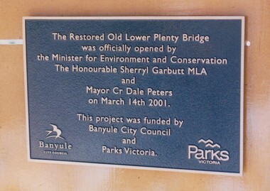
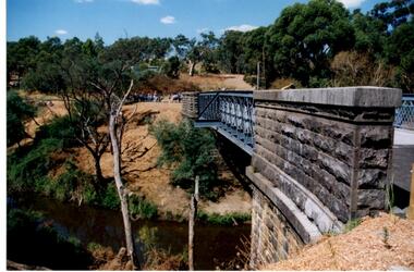
Photograph - Digital Image, Anne Paul, Plaque: Opening of restored Old Lower Plenty Bridge 2001, 14/03/2001
This plaque commemorates the opening of the restored Old Lower Plenty Bridge, opened on 14/03/2001 by the Minister for Environment and Conservation Sherryl Garbutt MLA and Mayor of Banyule Cr Dale Peters. The project was jointly funded by Banyule Council and Parks Victoria.Digital copy of colour photograph of memorial plaquelower plenty, lower plenty bridge, sherryl garbutt, dale peters, banyule council, parks victoria -
 Greensborough Historical Society
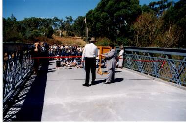
Photograph - Digital Image, Anne Paul, Opening of restored Old Lower Plenty Bridge 2001, 14/03/2001
The opening of the restored Old Lower Plenty Bridge, opened on 14/03/2001 by the Minister for Environment and Conservation Sherryl Garbutt MLA and Mayor of Banyule Cr Dale Peters. The project was jointly funded by Banyule Council and Parks Victoria. The restored bridge is the oldest remaining bridge in the former Shire of Eltham and forms part of the Plenty River Trail.Digital copy of colour photographlower plenty, lower plenty bridge, sherryl garbutt, dale peters, banyule council, parks victoria -
 Greensborough Historical Society
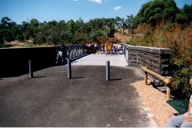
Photograph - Digital Image, Anne Paul, Opening of restored Old Lower Plenty Bridge 2001 - area adjacent, 14/03/2001
The opening of the restored Old Lower Plenty Bridge, opened on 14/03/2001 by the Minister for Environment and Conservation Sherryl Garbutt MLA and Mayor of Banyule Cr Dale Peters. The project was jointly funded by Banyule Council and Parks Victoria. The restored bridge is the oldest remaining bridge in Nillumbik and forms part of the Plenty River Trail. this photograph shows the area adjacent to the bridge on the day of the opening.Digital copy of colour photographlower plenty, lower plenty bridge, sherryl garbutt, dale peters, banyule council, parks victoria -
 Greensborough Historical Society
Photograph - Digital Image, Anne Paul, Opening of restored Old Lower Plenty Bridge 2001 - bridge and community, 14/03/2001
The opening of the restored Old Lower Plenty Bridge, opened on 14/03/2001 by the Minister for Environment and Conservation Sherryl Garbutt MLA and Mayor of Banyule Cr Dale Peters. The project was jointly funded by Banyule Council and Parks Victoria. The restored bridge is the oldest remaining bridge in the former Shire of Eltham and forms part of the Plenty River Trail. This photograph shows the bridge area ready for the opening ceremony and the assembled community members attending the function.Digital copy of colour photographlower plenty, lower plenty bridge, sherryl garbutt, dale peters, banyule council, parks victoria -
 Greensborough Historical Society
Photograph - Digital Image, Anne Paul, Opening of restored Old Lower Plenty Bridge 2001 - side view of bridge, 14/03/2001
The opening of the restored Old Lower Plenty Bridge, opened on 14/03/2001 by the Minister for Environment and Conservation Sherryl Garbutt MLA and Mayor of Banyule Cr Dale Peters. The project was jointly funded by Banyule Council and Parks Victoria. The restored bridge is the oldest remaining bridge in the former Shire of Eltham and forms part of the Plenty River Trail. This photograph shows the bridge from the side elevation, showing the bluestone and iron construction.Digital copy of colour photographlower plenty, lower plenty bridge, sherryl garbutt, dale peters, banyule council, parks victoria -
 Greensborough Historical Society
Photograph - Digital Image, Petrie Park Montmorency 1960s, 1960s
Petrie Park Montmorency, 1960s. This photograph shows the early development of Petrie Park, showing a dirt track to the oval and children's play equipment in foreground. The park is situated in Mountainview Road. Today the Montmorency Eltham RSL is also located in Petrie Park.Digital copy of black and white photographpetrie park montmorency, mountainview road montmorency, montmorency eltham rsl -
 Greensborough Historical Society
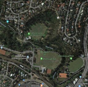
Aerial Photograph - Digital Image, Greensborough central with modern landmarks, 2015_
Aerial photograph of Greensborough showing modern landmarks and businesses, including Partington's Flat, Whatmough Park, Plenty River Trail. Bounded by Diamond Creek Road to the East and the Plenty River to the East, The Circuit to the South. Aerial photograph in colour with overlay text indicating modern landmarksgreensborough, manatunga circuit greensborough, plenty river, diamond creek road greensborough, the circuit greensborough, aerial photograph -
 Greensborough Historical Society
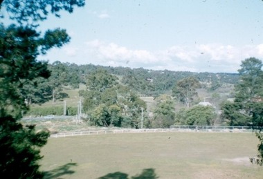
Photograph - Photograph - Digital Image, Greensborough Park 1958, 1958_
A photograph of Greensborough Park in 1958. There is a hawthorn or brush hedge along the roadside near the bridge which appears in other photos of the same date. Digital copy of colour photograph of the Greensborough Park 1958.greensborough park, hawthorn hedge -
 Greensborough Historical Society
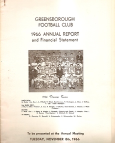
Annual Report, Greensborough Football Club: 1966 Annual Report and financial statement, 08/11/1966
Report to the Annual Meeting of the Greensborough Football Club. Outlines persons involved in the club, activities for the year and includes statistics and financial statement.A snapshot of the Greensborough Football Club in 1966. White card cover with photo of 1966 premier team. 12 pages. 2 copies.Back cover has an artist's impression of the proposed new hall and dressing rooms to be erected at the War Memorial Park in conjunction with the Park Trust and Greensborough Cricket Club.greensborough football club, annual report -
 Greensborough Historical Society
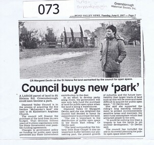
Article - Newspaper Clipping, Diamond Valley Leader, Council buys new 'park', 09/06/1987
Diamond Valley Council honours a commitment to purchase land for public open space in the South East Riding of Diamond Valley in 1987. The land is in St Helena Road Greensborough adjacent to St Katherine's Anglican Church.This land abuts St Katherine's Church St Helena, originally built by Anthony Beale and named for his wife Katherine Rose. Newspaper article photocopied onto A4 page, 3 columns of text under black and white photograph of Cr Margaret Devlin at St Katherine's Church St Helena. 2 copies.Diamond Valley News Tuesday June 9, 1987 - page 7.anthony beale, st helena, st katherines church, parks greensborough, beale reserve -
 Greensborough Historical Society
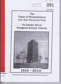
Book, The Tower of Remembrance and War Memorial Park on Garden Hill at Kangaroo Ground, Victoria, 1919o
Outlines the history of the Kangaroo Ground Tower of Remembrance from 1918 and the process undertaken by Nillumbik Council's Advisory Committee to refurbish the Tower. The Tower of Remembrance is a local landmark in Kangaroo Ground which had fallen into disrepair. This book documents the restoration of the Tower and Park c1997-2002Soft clear plastic front cover, red back cover. 107 pages, black and white illus. tower of remembrance, war memorials, kangaroo ground, nillumbik council, eltham district historical society -
 Greensborough Historical Society
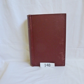
Book, Angus & Robertson Ltd, Official History of Australia in the War of 1914-18; by C. E. W. Bean. 8th edition, 1938_
The official history of Australia in WW1 written by C. E. W. Bean12 volumes. Hard cover, dark red binding. Maps and black and white illustrationsPresented to James Gordon Saunders Longfellow St Norman Park Q July 1950c e w bean, world war i, australia army, gallipoli -
 Greensborough Historical Society
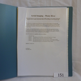
Folder, Aerial Imaging - Plenty River: by Ian Bryant, 2011_11
... ian bryant lower plenty greensborough yallambie park aerial ...Investigates early land use along the Plenty River from north of the main aqueduct crossing in Greensborough to south of the golf course in Lower PlentyHistorical features seen from aerial and satellite images of the modern landscape may indicate earlier agricultural land usage.9 x A4 pages of text and colour annotated maps downloaded from nearmap.com.plenty river, ian bryant, lower plenty, greensborough, yallambie park, aerial photography -
 Greensborough Historical Society
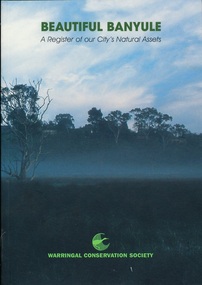
Book, Beautiful Banyule: by Carol Toomey, 1999_
A record of reserves and their features in the City of Banyule 1999. Full title: Beautiful Banyule: a register of out city's natural assets.A register of Banyule's natural assets104 pages, colour illustrations.Soft cover with treed skyline on front cover. 2 copies.Library labels.city of banyule, parks banyule, gardens banyule, historical sites banyule. -
 Greensborough Historical Society
Book, Nillumbik Shire Council, 1997 Community Guide Nillumbik, 1997_
Guide to services provided by Nillumbik Shire Council. Nillumbik Shire is located 25 kilometres north-east of Melbourne and the southern boundary is the Yarra River. The south of Nillumbik is predominantly urban, with commercial centres at Eltham and Diamond Creek. The north of the municipality includes significant natural features like Kinglake National Park and Sugarloaf ReservoirAnnual guide to services in Nillumbik. 64 pages. Cover is pale yellow with colour drawings. nillumbik shire council, handbooks -
 Greensborough Historical Society
Book, Nillumbik Shire Council, 1998 Community Guide Nillumbik, 1998_
Guide to services provided by Nillumbik Shire Council. Nillumbik Shire is located 25 kilometres north-east of Melbourne and the southern boundary is the Yarra River. The south of Nillumbik is predominantly urban, with commercial centres at Eltham and Diamond Creek. The north of the municipality includes significant natural features like Kinglake National Park and Sugarloaf ReservoirAnnual guide to services in Nillumbik 72 pages. Cover has white background and some 3-D artwork.nillumbik shire council, handbooks -
 Greensborough Historical Society
Book, Nillumbik Shire Council, 1999 Community Guide Nillumbik, 1999_
Guide to services provided by Nillumbik Shire Council. Nillumbik Shire is located 25 kilometres north-east of Melbourne and the southern boundary is the Yarra River. The south of Nillumbik is predominantly urban, with commercial centres at Eltham and Diamond Creek. The north of the municipality includes significant natural features like Kinglake National Park and Sugarloaf ReservoirAnnual guide to services in Nillumbik76 pages, illus. Cover has photographs of local people and title in white on orange background.nillumbik shire council, handbooks -
 Greensborough Historical Society
Book, Nillumbik Shire Council, Nillumbik Community Guide 2000/2001, 2000-2001
Guide to services provided by Nillumbik Shire Council. Nillumbik Shire is located 25 kilometres north-east of Melbourne and the southern boundary is the Yarra River. The south of Nillumbik is predominantly urban, with commercial centres at Eltham and Diamond Creek. The north of the municipality includes significant natural features like Kinglake National Park and Sugarloaf ReservoirAnnual guide to services in Nillumbik76 pages, black and white illustrations. Cover has a collage of local children with title in white on mid-blue background.nillumbik shire council, handbooks -
 Greensborough Historical Society
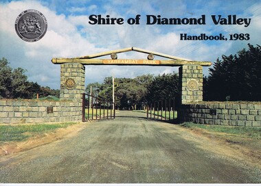
Book, Shire of Diamond Valley Handbook 1983, 1983_
Guide to services provided by Shire of Diamond Valley. The Shire of Diamond Valley was a Local Government Area located about 20 kilometres northeast of Melbourne. The shire covered an area of 74.38 square kilometres and existed from 1964 until 1994.Annual guide to services in Shire of Diamond Valley32 pages, col illus., maps. Cover illustration of the bluestone gateway, main entrance to Yarrambat Park, opened 1982.shire of diamond valley, greensborough, handbooks -
 Greensborough Historical Society
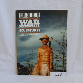
Book, Banyule City Council, Greensborough War Memorial Sculptures, Leigh Conkie, 2004_
These chainsaw sculptures were carved from the stumps of trees originally planted around the park. The carver was Leigh Conkie. The trees had become diseased and were in danger of falling.Memorial to local people who fought in the various wars of the 20th century. 21 pages, colour illustrationsgreensborough war memorial park, sculptures, ester street, leigh conkie, chainsaw sculptures