Showing 110 items
matching map - gold mines in victoria
-
 Bendigo Historical Society Inc.
Document - MARKS COLLECTION: MAP OF VICTORIA REEF MINING CLAIMS
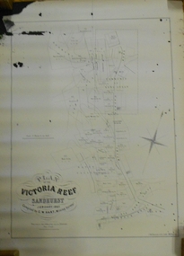
Copy of map. On bottom LH side: Plan of the Victoria Reef Sandhurst January 1867, Compiled by G.W. Hart, Mining Surveyor. Published by John N. Macartney, Argus Agent, Sandhurst. Price 4/- each. On bottom Rh side J.W. Pearson & Co. Lith. Melbourne Plan shows mining claims and names of holders, scale (4 chains to one inch) Loddon Road, Mount Korong Road, Ironbark Gully, township of Long Gully, Quartz Miners' Arms and Gold Mines Hotel on Loddon Road.bendigo, mining, victoria reef plan -
 Bendigo Historical Society Inc.
Map - BELLE VUE NO 2 - PLAN OF LEASES
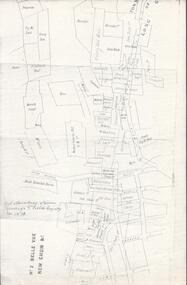
BHS CollectionPlan of Mining Leases from Rowan Street to Long Gully. Reference J. N. Macartney 2nd Edition Bendigo Goldfields Registry for 1872. Names of Leases are: Moore ?, Ellesmere Co, Bonati & Co, Dennis, Abe Lincoln Co, Lansell & Hunt, Black & White Lead Co, Koch & Hildebrand, Ballerstedt, Lazarus Co No 1, Lazarus Co, Watson, Lazarus Freehold, Lazarus Co No 2, Lazarus Tribute, South Extended Burra, Endeavor Co, Old Chum Co, Burrows and Sterry, New Chum & Victoria Trib, Jackson, North Old Wybrants Chum Co, Myra Co, McLenn, Geary & Co, Western Victoria Hill G. M. Co, Victoria Reef G.M.Co, South Adventure Co, South Try Me Well, W. Rae, Wells Midway, Extended Co, Handy Andy, Moonta Co, Humboldt Co, Adventure Co, Try Me Well, Sterry & Co, Midway, Tudor, Friedman's Reef, Rising Sun, Try Me Luck, Pomponia, Confidence Co, Alfred Co, Advance Co, Prince Alfred Co, Canterbury Co, Platus Co, S. Platus Co, Golden Fleece United, Alfred Co, Iron Duke Co, Victoria Gold Mines Co, Hercules Co and Iron Bark. Notes prepared by Albert Richardson.map, bendigo, mining plan, belle vue no 2, no 2 belle vue new chum & c, j n macartney bendigo goldfields registry 1872, moore ?, ellesmere co, bonati & co, dennis, abe lincoln co, lansell & hunt, black & white lead co, koch & hildebrand, ballerstedt, lazarus co no 1, lazarus co, watson, lazarus freehold, lazarus co no 2, lazarus tribute, south extended burra, endeavor co, old chum co, burrows and sterry, new chum & victoria trib, jackson, north old wybrants chum co, myra co, mclenn, geary & co, western victoria hill g. m. co, victoria reef g.m.co, south adventure co, south try me well, w. rae, wells midway, extended co, handy andy, moonta co, humboldt co, adventure co, try me well, sterry & co, midway, tudor, friedman's reef, rising sun, try me luck, pomponia, confidence co, alfred co, advance co, prince alfred co, canterbury co, platus co, s. platus co, golden fleece united, alfred co, iron duke co, victoria gold mines co, hercules co, iron bark -
 Bendigo Historical Society Inc.
Document - VICTORIA HILL - KEY TO SIGN POSTS ON AREA MAP
Three page hand written carbon copy of Sign numbers at Victoria Hill. No 1 North Old Chum Shaft, No 2 Ballerstedt's First Open - Cut. Special Sign Post, No 2 C Rock Formations Pitching North, No 2 B Rich shallow shafts, No 2 A Quartz veins, No 4 A Concrete Dams, No 3 Engine Beds - Lansell's 'Big 180' Mine, No 3 B Lansell's 'Big 180' Shaft, No 4 Twenty Stampers Crushing Battery, No 3 C Foundations - 'Cleopatra Needle' type Chimney for Lansell's 'big 180' Mine, No 5 Victoria Quartz Mine, No 5 A Fou;ndations Victoria Quartz Poppet Legs, No 5 C Foundations Victoria Quartz Winding Plant, No 5 B Victoria Quartz Dams, No 6 Rae's Open - Cut, No 9 Quartz Once Roasted Here, No 12 Anticlinal Arch, No 15 primitive Tunnels, No 14 Beautifully Coloured Rock Formations, No 16 Adit, Graded Bedding, Oblique Fault, Spurry Quartz Veins, No 17 Prospecting Tunnels, No 18 Floyd's Small Crushing Battery, No 19 Gt Central Victoria (Midway) Shaft, No 20 Great Central Victoria (Midway) Engine Bed, No 21 ballerstedt's Small 24 Yard Claim, No 22 Humboldt Shaft, No 23 Wittscheibe's 'Jeweller's Shop', No 24 The 'Adventure' ground, Large Open - Cut, No 26 Luffsman and Sterry's Ground, NO 27 A Round Shaft, Notes prepared by Albert Richardson.mine, gold, victoria hill, victoria hill, victoria hill key to sign posts on area map, north old chum shaft, ballerstedt's first open cut, lansell's big 180 shaft, 'cleopatra needle' type chimney, victoria quartz mine, rae's open cut, prospecting tunnels, floyd's small crushing battery, gt central victoria (midway) shaft, ballerstedt's small 245 yard claim, humboldt shaft, wittscheibe's 'jeweller's shop', adventure, luffsman and sterry's ground, david sterry, sterry's 'gold mines' hotel, round shaft -
 Bendigo Historical Society Inc.
Document - VICTORIA HILL - VISITOR PLANS FOR VICTORIA HILL
Handwritten carbon copy and typed copy of notes on 1st and 2nd stage plans for a tourist area on approx. 20 acres at Victoria Hill. First stage was to clean up the area, locate and sign post shafts, engine beds, etc and prepare a topographical map with these features on it. Second stage was to arrange for the purchase of typical miners homes and shops in the vicinity to be restored for inspection by visitors. Mining equipment to be placed in the area. Prepare brochures for sale. Set up a mining museum.Prepare an area near BCV 8 with direction finder to mining and general features, as this has the best natural ground level view in the City. Notes prepared by Albert Richardson.mine, gold, victoria hill, victoria hill, visitor plans for victoria hill, darrel mcclure, bendigo city council, bendigo historical society, central nell gwynne, caleb thomas, bcv 8, lazarus, old chum, new chum, victoria, repeater station (p. m. g.) -
 Bendigo Historical Society Inc.
Document - VICTORIA HILL - CLASSIFICATION REQUEST
Handwritten, 3 page carbon copy of a classification request for victoria Hill. Notes give locality, housing program in the area, immediate surrounds of the area, prominent citizens, buildings, mines, geographical formations and gold production. Notes prepared by Albert Richardson.mining, parish map, victoria hill, classification request for victoria hill, gold mines hotel, john brown knitwear factory, lansell's fortuna villa, army survey corp, housing commission, hercules, energetic, ironbark, manchester arms hotel, bendigo goldfield, old miners homes, george lansell, sir george lansell, bendigo advertiser, theodore ballerstedt junior, mr c t c johann ballerstedt, mr wm rae, david sterry, adventure, wittscheibe's 'jewellers shop', luffsman & sterry's rich claim, ballerstedt open cut and mine, lansells 180, victoria quartz, rotary club of bendigo south, bendigo cemetry -
 Bendigo Historical Society Inc.
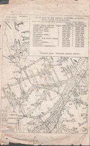
Document - MINING REPORTS - MAP OF PART OF THE BENDIGO GOLDFIELD INCLUDING WHITE HILLS AND EAGLEHAWK
BHS CollectionMap of part of the Bendigo Goldfield including White Hills and Eaglehawk. Map shows reef lines, gullies, railway line, tram route, type of rock, name of mine, Calls and Dividends. Also Deepest Mine Victoria Quartz 4614 ft. Names of Mines are Garden Gully United, Great Ext'd Hustlers, Johnson's Reef, South New Moon, New Moon, Catherine Reef, Virginia, Central Red White & Blue, Ironbark, Kock's Pioneer, Carlisle and the Hercules & Energetic. Map is part of the Albert Richardson Collection of mining documents and research. document, gold, mining reports, mining reports, map of part of the bendigo goldfield including white hills and eaglehawk, pabst bendigo goldfield, garden gully united, great ext'd hustlers, johnson's reef, south new moon, new moon, catherine reef, virginia, central red white & blue, ironbark, kock's pioneer, carlisle, hercules & energetic. victoria quartz -
 Bendigo Historical Society Inc.
Map - MINING PLAN ,VICTORIA HILL AREA, No date visible
... MAP Bendigo mining plan Mining Gold Mines Victoria Hill ...Map: Large scale plan of an area of the Goldfield, Northward from Barnard Street, covering the Victoria Hill area. Black printing on polycarbonate film. Transparent.map, bendigo, mining plan, mining, gold mines, victoria hill, lines of reef -
 Clunes Museum
Book - ADMINISTRATIVE REPORT, JOHN TAYLOR & SON, REPORT ON THE CLUNES GOLD FIELD STATE OF VICTORIA, AUSTRALIA, 1935
WRITTEN REPORT OF JOHN TAYLOR AND SONS, LONDON OF THE EXAMINATION OF THE PROPOSAL TO REOPEN THE GOLD MINES SITUATED IN THE TOWNSHIP OF CLUNES...HARDCOVER BOOK CONTAINING REPORTS BY THE MINING REGISTRARS WITH MAPS OF THE CLUNES GOLD FIELDWRITTEN REPORT OF JOHN TAYLOR AND SONS, LONDON OF THE EXAMINATION OF THE PROPOSAL TO REOPEN THE GOLD MINES SITUATED IN THE TOWNSHIP OF CLUNES...gold mining, commercial report, clunes mines to reopen, 1935 -
 Bendigo Historical Society Inc.
Map - HUSTLER'S REEF & HUSTLER'S REEF NO 1 MINES - LONGITUDINAL SECTION OF THE HUSTLER'S REEF & HUSTLER'S
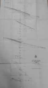
Longitudinal Section of the Hustler's Reef & Hustler's Reef No 1 Mines on the Hustler's Line of Reef. Bulletin No 33, Plate No XX. Note - Plates 4, 8, 13, 20, 26 & 31 form a Longitudinal Section from Fortuna Hustler's to Hustler's Consols Mine. Geological Survey of Victoria emblem. Signed by H A Whitelaw, Underground Survey Office Bendigo, September 1913. Shows the two shafts with their levels and depths. Also shows geographical features and yields of gold and amalgam per ton. .mining, parish map, hustler's reef & hustler's reef no 1 mines, geographical survey of victoria, underground survey office bendigo, h a whitelaw -
 The Beechworth Burke Museum
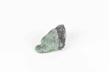
Geological specimen - Green Feldspar (orthoclase)
Feldspar, derived from the German word feldspat, is a group of minerals which is the most common mineral group found on Earth, making up more than half of the planet's crust. The major rock-forming minerals in the Feldspar group include albite, anorthite, orthoclase and microcline. (Mindat, Feldspar Group). Orthoclase is part of the Feldspar Group subgroup, Alkaline Feldspar, which are known to be poor in calcium, and mostly rich in potassium. It is further also considered to be a K Feldspar, a subgroup of Alkaline Feldspar that are Potassium-dominant with variable crystal symmetry and Al-Si ordering state. Orthoclase are most commonly Colorless to white, Greenish white, Grayish yellow, or Pale pink and transparent to translucent with slightly pearly cleavage. The mineral rates at a 6 on the Mohs Hardness Scale. (cannot be scratched with a knife, but scratches glass with difficulty). The stronger green colour of this particular specimen is distinctive to the Broken Hill region (where it was found), and due to a small amount of lead. (BB) Its qualities find it misidentified at times as as microcline variety amazonite. Broken Hill is one of the world’s richest lead-zinc-silver deposits. The huge, 300-million-tonne orebody was discovered in 1883 and the superb mineral specimens attract collectors from around the world. (Australian Museum, Minerals from Australia: Australian mining regions)While feldspar is not by any means rare, this particular specimen has qualities distinctive to the Broken Hill mining district, with these properties leading at times to the mineral's misidentification. This creates potential for further study and identification of these mineral deposits through methods such as microscopic twinning, or using the position of certain d values in XRD patterns to calculate the degree of disorder of a K-feldspar, as discussed on the Mindat website (Mindat.com, Orthoclase:About Orthoclase). This specimen is part of a larger collection of geological and mineral specimens collected from around Australia (and some parts of the world) and donated to the Burke Museum between 1868-1880. A large percentage of these specimens were collected in Victoria as part of the Geological Survey of Victoria that begun in 1852 (in response to the Gold Rush) to study and map the geology of Victoria. Collecting geological specimens was an important part of mapping and understanding the scientific makeup of the earth. Many of these specimens were sent to research and collecting organisations across Australia, including the Burke Museum, to educate and encourage further study.A solid small aluminosilicate mineral composition which is primarily pale green and blue-grey in colour with traces of beige and white throughout. Note: green plumbian orthoclase (aka green feldspar) is an indicator mineral for the Broken Hill style lead-zinc deposits.N/Abroken hill mine, geological specimen, minerology -
 Bendigo Historical Society Inc.
Map - HUSTLER'S ROYAL RESERVE NO 2 CO. - LONGITUDINAL SECTION OF THE HUSTLER'S ROYAL RESERVE NO 2 CO
Longitudinal Section of the Hustler's Royal Reserve No 2 Co. on the Hustler's Line of Reef Bulletin No 33, Plate No VIII. Note - Plates 4, 8, 13, 20, 26 & 31 form a Longitudinal Section from Fortuna Hustler's to Hustler's Consols Mine. Mines mentioned are the Hustler's Royal Reserve No 2 Main Shaft, Hustler's Royal Reserve No 2 Park Shaft, Royal Hustler's, Imperial Hustler's, Great Extended Hustler's Freehold and the Great Extended. Section shows depth of levels, datum lines and height of sill above sea level yield in oz. of gold. Geological Survey of Victoria emblem. H. Herman, Director, W. Dickson, Secretary for Mines and The Hon. J. Drysdale Brown MLC, Minister for Mines and signed by H S Whitelaw, Underground Survey Office Bendigo, September 1913. mining, parish map, hustler's royal reserve no 2, royal hustler's, imperial hustler's, great extended hustler's freehold, great extended, geological survey of victoria, underground survey office bendigo, h s whitelaw, h herman, w dickson, the hon j drysdale brown -
 Bendigo Historical Society Inc.
Map - UNITED HUSTLER'S & REDAN & K. K. MINES - PLAN OF THE UNITED HUSTLER'S & REDAN & K. K. MINES
Plan of the United Hustler's & Redan & K. K. Mines Bulletin No 33 Plate No XXXI. Shows depth of levels, Probable positions of reefs and natural surface with the poppet legs at the two shafts. Sill of shaft of the K. K. Mine 773.56 ft above Sea Level and sill of shaft of the United Hustler's & Redan Mine 745.62 above Sea Level. Also mentioned is the average amount of gold obtained per ton. Note on the top of page - Plates 4, 8, 13, 20, 26 & 31 form a Longitudinal Section from Fortuna Hustler's to Hustler's Consols Mine. Geological Survey of Victoria emblem and signed by H S Whitelaw, Underground Survey Office, Bendigo, September 1913. mining, parish map, united hustler's & redan & k. k. mines, geological survey of victoria, h s whitelaw, underground survey office bendigo -
 Bendigo Historical Society Inc.
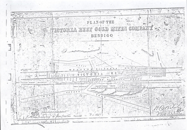
Document - VICTORIA HILL - PLAN OF THE VICTORIA REEF GOLD MINES COMPANY BENDIGO
3587.70 same as 3587.69. Copied onto smaller white paper.map, bendigo, victoria hill, plan of the victoria reef gold mines company bendigo -
 Bendigo Historical Society Inc.
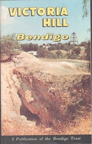
Book - VICTORIA HILL - VICTORIA HILL BENDIGO
Booklet titled: 'Victoria Hill Bendigo A Publication of the Bendigo Trust'. Booklet has photos of the Central Nell Gwynne Mine, Victoria Hill in the 1860's, with Rae's Battery in the foreground, geographical features, Rae's Open Cut, Victoria Hill from the New Chum Hill in the 1870's, compressor beds, The Victoria Quartz Mine, burnt ground from quartz roasting, the remains of a twenty head crushing battery, a view from Ballerstedt's Open Cut showing the historic Gold Mines Hotel built in 1857 and the engine beds of Lansell's '180' mine. There are also two maps, History of Victoria Hill and geographical notes on the area.book, bendigo, victoria hill -
 Bendigo Historical Society Inc.
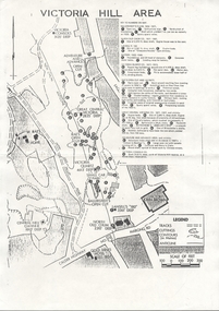
Document - VICTORIA HILL - VICTORIA HILL AREA MAP
... MAP Bendigo Victoria Hill Victoria Hill Map Gold Mines ...Photocopied map on cream paper. Map is the Victoria Hill area showing the locations of the Gold Mines Hotel, John Brown Factory and W Rae's Home. Map also shows mine shafts and open cuts.map, bendigo, victoria hill, victoria hill map, gold mines hotel, john brown factory, w rae's home, victoria consols, adventure and advance open cut, great central victoria, rae's open cut, victoria qiartz, ballerstedt's open cut, lansell's '180', north old chum, central nell gwynne -
 Bendigo Historical Society Inc.
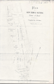
Map - NEW CHUM & VICTORIA LINES OF REEF - PLAN OF NEW CHUM & VICTORIA LINES OF REEF
Two pages of a Plan of New Chum & Victoria Lines of Reef, compiled by G. W. Hart. Taken from J. N. Macartney's G'Fields Registry for 1871. Plan shows leases from High Street to California Gully. Location of the Manchester Arms, British & American Hotel and the Quartz Miners Arms are shown. Townships of Long Gully and Ironbark are shown.map, goldfields, new chum & victoria lines of reef, victoria catharine g m coy, thornton & co, extd victoria reef g m co, ural tribute compy, nil desperandum compy, koch, north victoria g m co, danger hill coy, north endeavour coy, wheadon & co, pilot co, north energetic co, energetic compy, endeavour company, hercules co, victoria gold mines compy, iron duke g m co, golden fleece united, ballerstedt, alfred co, confidence co, prince alfred co, canterbury co, advance co, wells, humboldt co, adventure co, try me well, sterry & co, gibbs & ballerstedt, handy andy, wells?, south adventure co, w rae, victoria reef quartz m co, myra co, jackson, wybrants, burrows & sterry, new chum & victoria tribute, old chum co, ballerstedt, lazarus, watson, koch & hildebrand, lansell & hunt, dennis, abe lincoln co, bonati & co, ellesmere co, moore late menzies, british co, british tribute co, garibaldi, c c co, new chum trib, dobson & co, young chum co, little chum co, old chum co, new chum trib, little chum trib, g w hart, j n macartney's g'fields registry for 1871, manchester arms, british & american, quartz miners arms -
 Bendigo Historical Society Inc.
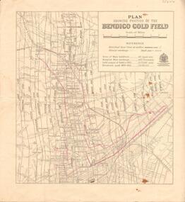
Map - BENDIGO GOLD FIELD - MAP OF PORTION OF THE BENDIGO GOLD FIELD
Map showing portion of the Bendigo Gold Field showing Alluvial working, shaft sites , streets and lines of reefs.Department of Mines, Victoria. Many mines, lines of reefs and gullies are on the map. Blue Royal Historical Society of Victoria Bendigo Branch stamp on the back.document, bendigo gold field, department of mines, lines of reefs, gullies, mines -
 Bendigo Historical Society Inc.
Map - GREAT EXTENDED HUSTLER'S MINE - LONGITUDINAL SECTION OF THE GREAT EXTENDED HUSTLER'S MINE
Longitudinal Section of the Great Extended Hustler's Mine on the Hustler's Line of Reefs. Bulletin No 33, Plate No XIII. Map shows the Hustler's Tribute, 2 Old Shafts, Great Extended Hustler's Shaft, Latham & Watson's Shaft and Ironbark Gully. Datum Line 750 feet above Sea Level. Poppet Legs on the surface and Sill of Shaft 788.99 feet above Sea Level. Levels and their depths are shown and some geographical features. Some amounts of gold mined mentioned. Geological Survey of Victoria emblem and signed by H A Whitelaw, Underground Survey Office Bendigo, September 1913. Note - Plates 4, 8, 13,20, 26 & 31 form a Longitudinal Section from Fortuna Hustlers to Hustler's Consols Mine. mining, parish map, great extended hustler's mine, geological survey of victoria, underground survey office bendigo, h a whitelaw, hustler's tribute, old shaft, great extended hustler's shaft, latham & watson's shaft, ironbark gully -
 Bendigo Historical Society Inc.
Map - FORTUNA HUSTLER'S MINE - LONGITUDINAL SECTION OF THE FORTUNA HUSTLER'S MINE
Longitudinal Section of the Fortuna Hustler's Mine on the Hustler's Line of Reef, Bendigo. Bulletin No 33, Plate No IV. Shows poppet legs at the surface level, Datum Line 750 feet above Sea Level, levels and their depths, the amount of gold per ton and some geographical features. Geological Survey of Victoria emblem and signed by H A Whitelaw, Underground Survey Office, Bendigo. Note - Plates 4, 8, 13, 20, 26 & 31 form a Longitudinal Section from Fortuna Hustler's to Hustler's Consols Mine. mining, parish map, fortuna hustler's mine, longitudinal section of the fortuna hustler's mine, geological survey of victoria, h a whitelaw, underground survey office bendigo, hustler's line of reef, hustler's consols mine -
 Bendigo Historical Society Inc.
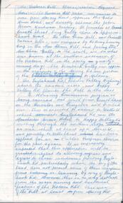
Document - VICTORIA HILL - SKETCH MAP - VICTORIA HILL
Hand drawn sketch map of mines and depth. Some have distances between the shafts. Mines mentioned are: Great Central Victoria, Ballerstedt, Humboldt and Sterry's.document, gold, victoria hill, sketch map - victoria hill, great central victoria, ballerstedt, humboldt, sterry's