Showing 94 items
matching mccalls
-
 Sunbury Family History and Heritage Society Inc.
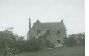
Photograph, Rosa McCall, Cumberland Homestead, 1951
The homestead in the image is 'Cumberland' which was sited along the Moonee Ponds Creek, near Gellibrand Hill. It was built by Donald Coghill, who acquired the land some time in the 1850s. During the first half of the twentieth century it was uninhabited until it was finally demolished.'Cumberland' was one of a number of homesteads that were built by European settlers in the Bulla area in the 1850s. A non-digital black and white photograph of a double storey Victorian homestead set in an open area.cumberland homestead, moonee ponds creek, gellibrand hill, donald coghill -
 Sunbury Family History and Heritage Society Inc.
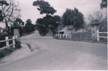
Photograph, Rosa McCall, Old Broadmeadows Township, 1949
The small town in the photograph is the former Broadmeadows Township (now part of Westmeadows). It was situated on the Old Sydney Road (Mickleham Road) and 2 miles east of the Broadmeadows Station. The stone bridge in the foreground spans the Moonee Ponds Creek and Fawkner Street is the road, which leads southwards to Gladstone Park and Tullamarine. The little building was a lolly shop that Mrs. Ethel Mitchell owned and ran for many years.Until 1869, before Sydney Road was finally opened, travellers on their way to Sydney would pass through the Broadmeadows Township.A copy of a non-digital black and white photograph of a road way with a bridge in the foreground leading to a small settlement. Small building with a pitched roof and a verandah is on the RHS of the image and the road leading out of the town is bordered with an avenue of pine trees.old broadmeadows township, fawkner street, moonee ponds creek, westmeadows, bridges -
 Broadmeadows Historical Society & Museum
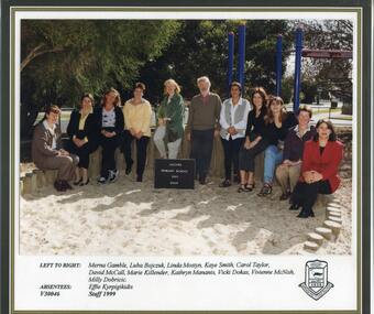
Photograph - School Photo, Fotek School Portraits, Jacana Primary School 1999 Staff Photograph, 1999
This 1999 photograph of staff at Jacana Primary School captures a significant moment in the history of a community-oriented institution that served Melbourne’s northern suburbs from 1959 until the early 2000s. More than just a staff portrait, the image reflects the enduring spirit of a school deeply embedded in its local context—one that championed educational access, fostered a strong sense of belonging, and played a vital role in shaping community identity. As a visual record, it offers valuable insight into the educational culture, staff dynamics, and broader social values of suburban Melbourne at the close of the 20th century. This 1999 photograph of Jacana Primary School staff holds considerable historical and cultural value as a visual record of a school that played a pivotal role in the educational and social fabric of Melbourne’s northern suburbs. Operating from 1959 until the early 2000s, Jacana Primary was more than an educational institution—it was a cornerstone of community life, fostering inclusion, resilience, and opportunity for generations of students and families. The image is significant for its ability to convey the ethos of the school at the close of the 20th century, reflecting broader trends in public education, suburban development, and community identity in Victoria. It offers insight into the people who shaped the school’s legacy and serves as a tangible link to the shared experiences and values of the Jacana community.A colour photograph depicting teachers at Jacana Primary School, taken in 1999. The image is bordered by a black frame and features a white strip along the bottom edge with names of individuals neatly printed. The Jacana Primary School logo is located in the bottom right-hand corner. Photograph is laminated. jacana primary school, education, photograph, group photograph, ms. carol taylor, 1999, merna gamble, luba bojczuk, mrs. linda mostyn, mrs. kaye smith, david mccall, marie killender, kathryn mananis, vicki dokas, mrs. vivien mcnish, ms. milly dobricic, effie kyrpigikidis -
 Sunbury Family History and Heritage Society Inc.
Photograph, Rosa McCall, Sunbury Cultural Ring, May 2018
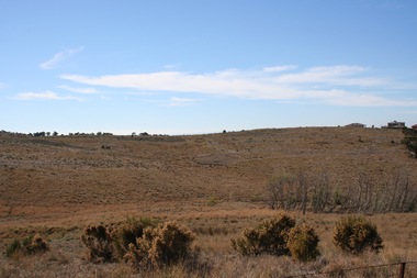
The photograph is of one of the Sunbury Cultural Rings sites. There are three Aboriginal earthen rings. The one in the foreground which is clear of weeds has been formed as a round dip in the earth and it is thought it was used as an Aboriginal gathering place. They are owned and managed by the Wurundjeri Tribe Land Council.The rings bear evidence of Aboriginal settlement and land use in the area. A coloured landscape photograph of open grassland and hills across the valley with a few native trees growing . aboriginal cultural rings, sunbury, jacksons creek, wurundjeri people