Showing 8398 items matching "mckillops-bridge"
-
 Ringwood and District Historical Society
Photograph, Mullum Mullum Creek new bridge work commences. Warrandyte Road, Ringwood - 1986
Start of new bridge, Warrandyte Rd. Ringwood 1986 (2 views)Written on back of photograph, "Start of new bridge, Warrandyte Rd. 1986." -
 Chelsea & District Historical Society Inc
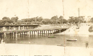
Photograph - Patterson River, Rail and Road Bridge, c 1912
The first bridge over the river was built in the early 1880's, prior to this it was a pontoon bridge.Sepia photo of the road bridge (Point Nepean / Nepean Highway) and rail bridge, near the mouth of the Patterson River., Carrum patterson river, road bridge, rail bridge, chelsea, transport, patterson river bridge, carrum bridge -
 South Gippsland Shire Council
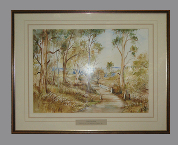
Framed watercolour painted by Bianca Biesuz, "Dryings Road Bridge", 1987
Painted by Bianca BiesuzCream card window mount with pink edging lines. Text panel cut out lower edge. Brown wood frame with gold edging. Painting portrays trees with a pathway through them, white bridge,"Dryings Road Bridge" -
 Linton and District Historical Society Inc
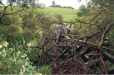
Photograph, Dilapidated bridge over Springdallah Creek, Happy Valley/Piggoreet, 2010
Already in a dilapidated condition, the bridge was further damaged by storms and floodwaters in 2010 and 2011. In 2025, little remains of the old bridge.Colour photograph showing damage to the Old Springdallah Bridge - a trestle bridge spanning Springdallah Creek, on Linton-Piggoreet Road. trestle bridges, old springdallah bridge -
 Lakes Entrance Historical Society
Photograph - North Arm bridge Lakes Entrance Victoria, M Fish, 1970 c
concrete bridge over North Arm taken from Eastern side of bridge southern shore of North Arm Lakes Entrance Victoria. Bridge built 1916 to 1917 demolished after opening of new bridgeColour photograph of concrete bridge over North Arm taken from Eastern side of bridge southern shore of North Arm Lakes Entrance Victoriabridges, topography -
 Kew Historical Society Inc
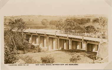
Postcard, Valentine Publishing Co Pty Ltd, New Yarra Bridge, Between Kew and Heidelberg, 1926-1930
Without bridges, Kew remained cut off from the City of Melbourne, only being accessible by Punt. Private and public bridges were constructed from the 1850s, beginning with the Hawthorn Bridge linking Bridge and Burwood Roads. A bridge across the Yarra at Burke Road was created as early as 1873. Since that first wooden bridge, a number of later bridges, typically on concrete pylons have been built, in 1926 and again during the 1970s.Angle view of the new Yarra bridge [ie. The Burke Road bridge] taken from the Kew side, showing the bridge’s structure. Trees line the river’s edge. In the distance can be seen a distant line of houses stretching to the horizon. The river appears to have an S-shaped bend beyond the bridge. The postcard, No. 227, was produced by the Valentine Publishing Co. Pty Ltd., of Queen Street, Melbourne.burke road bridge - kew (vic), bridges - kew (vic) -
 Stawell Historical Society Inc
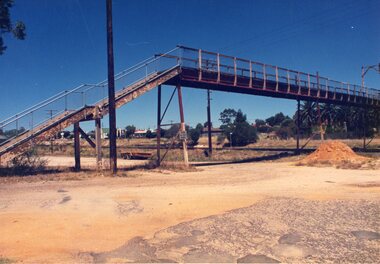
Photograph, Railway Step Bridge Stawell
Railway Step Bridge StawellTwo (2) Colour Photgraphs of a Pedestrian Bridge across Railway Tracks. One showing the bridge in the mid distance, with a mound of soil in front. The Second looking across the bridge, with houses in the distancestawell, railway -
 Kew Historical Society Inc
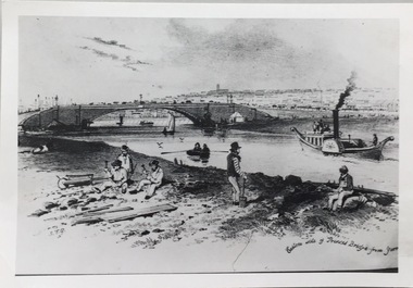
Photograph - Photograph (copy), S T Gill, Eastern side of Princess Bridge From Yarra, 1860-1880 (original)
Copy of a painting (or etching) by S.T. Gill showing the Yarra River at Princess Bridge, Melbourne.Inscription reverse: "Eastern side of old Princess Bridge from Yarra"reproductions -- s t gill, princess bridge -- river yarra - melbourne (vic.) -
 Anglesea and District Historical Society
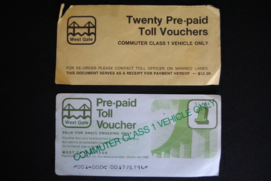
Toll Vouchers, West Gate Bridge Authority, Estimated 1980
6 x Pre-paid Toll Vouchers valid for commuter class 1 vehicle only. Valid for one crossing of the West Gate Bridge. 1 x Cover (yellow) - Twenty Pre-paid Toll Vouchers. Commuter Class 1 Vehicle Only. For Re-order please contact Toll Officer on Manned Lanes. This doument serves as a receipt for payment hereof - $12.00.Pre-paid / Toll Vouchers / COMMUTER CLASS 1 VEHICLE ONLY / West Gate Bridge / Re-order - P.O. Box 127, Port Melbourne 3207 Phone 645 1599. West Gate Bridge symbol. toll, pre-paid voucher, melbourne, transport freeways, road bridges, west gate -
 Port of Echuca
A black and white photograph, The Bridge Hotel, in 1896, showing Silky Oak trees, 1970's
The Bridge Hotel was built by Henry Hopwood to house visitors to the town crossing the Murray River on his punt crossing, which was situated just below the Bridge Hotel on the Murray River. The accommodation was spacious and grand! In the right back corner of the photograph, the 'lantern' roof of the St Georges Hall can be seen. The street is level with the front entrance to the Hotel, which is very different to what it is today.The photograph shows hotel activities and accommodation in the late 19th Century.A black and white photograph of the Bridge Hotel taken from the Hopwood Gardens. The photograph shows four silky oak trees growing along the front of the building. There is an empty flag pole outside the front of the building. The right wing advertises billiards, whilst the left wing apparently was a bar.Written on the building can be seen the words; HOTEL and BILLIARDS. Written in pen on the back of the photograph are the words "Bridge Hotel. Probably 1896, showing Silky Oak trees.bridge hotel, henry hopwood, silky oak trees, lantern roof, st georges hotel -
 Phillip Island and District Historical Society Inc.
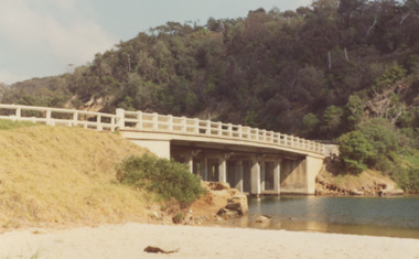
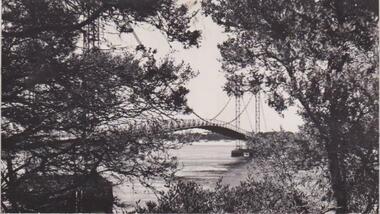
Photograph, Phillip Island Bridge
Glimpse of arched bridge between trees from left to right of photograph. Scrubby low bush in foreground. Tranquil water behind and under bridge to Newhaven sand beyond.Glimpse of bridge, San Remolocal history, photographs, bridges, san remo, black & white photograph, mona condrick -
 Phillip Island and District Historical Society Inc.
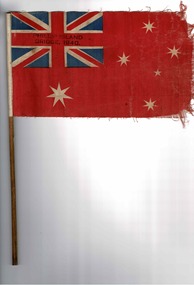
Flag, Flag for 1st bridge opening
Flag waved by school children at opening of Phillip Island Bridge HistoricalRed cloth flag with Union jack in left corner and southern cross. On thin wooden stickPhillip Island bridge 1940flag, opening of phillip island bridge 1940 -
 Buninyong Visitor Information Centre
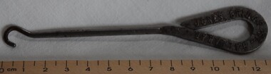
Clothing - Button Hook, Button Hook from Jones, Bridge Street, Ballarat
Item sold by Jones, a shop located in Bridge Street, Ballarat.Metal button hook with hoop shaped handle, a narrow shaft ended with a small hook. The shop details are printed in relief on the handle.Jones, Bridge Street, Ballaratfootwear, clothing accessories, button hooks -
 Clunes Museum
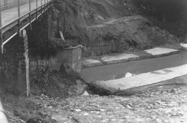
Photograph, WHEELERS BRIDGE
SEPIA PHOTOGRAPH OF CONSTRUCTION OF "WHEELERS" BRIDGE AT LAWRENCE MOUNTED ON CARDBOARDTHE FIRST REINFORCED CONCRETE BRIDGE IN AUSTRALIA. ENGINEER - JOHN MONASH. LATER SIR JOHN MONASH.local history, photography, photographs, bridges -
 Wodonga & District Historical Society Inc
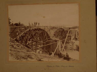
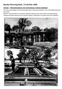
Photograph - Wodonga Creek Stock Bridge Collection
The Wodonga Creek Stock Bridge was constructed by the Country Roads Board in 1939. The date was recorded on a small plaque attached to one of the trestles. The bridge is an important reminder of one of the industries Wodonga was built on — cattle. It was constructed to develop a new stock route between Albury and Wodonga which would direct cattle away from the main bitumen roads and traffic bridges to the Wodonga Saleyards, where thousands of sheep and cattle were sold each month. It is a moderately tall timber trestle road bridge consisting of nine spans, with a deck length of 76 metres and deck width of 4.5 metres, and a maximum span length of 8.5 metres. The substantial timber deck featured decking laid horizontally and longitudinal running planks laid on top of it. The bridge also has timber side safety rails to discourage livestock from straying over the side. The bridge also became the centre of summer social activity for the young people of Wodonga as the area became a gazetted swimming area before the Wodonga Swimming Pool was constructed in 1959. In 1980 the Wodonga Saleyards were relocated to Bandiana to the east of the city. This meant that Wodonga Creek Stock Bridge was no longer needed for its original purpose. Although listed as a significant site by the Victorian Heritage and National Heritage Trust on 3/08/1998, the bridge fell into disrepair and also suffered damage from several floods. A suspension Bridge was constructed beside the Stock Route Bridge in 2013 and the old bridge was closed to traffic. Major damage caused by several floods, including a major flood in 2022 has resulted in the bridge being unsafe and its future is uncertain. The model of the Wodonga Creek Stock Bridge in our Collection made by Mr John Wild, depicts its current condition.The Wodonga Creek Stock Bridge is significant for technical, historic and social reasons and has been registered at the State Heritage level. It is of technical significance as a nine span bridge with tall timber trestles. Large bridges of this type are now very rare in Victoria. It is of historic significance as a surviving structurally authentic bridge designed specifically for livestock and drover use, on a historic stock route. The Stock Bridge is of social significance for its location at a popular riverside leisure spot since its construction in 1939.A collection of photographic images depicting the Wodonga Creek Stock Bridge. It contains both black and white and coloured images taken at different times in the Stock Bridge's history. A model of the Bridge made for Our Society is also included.wodonga creek stock bridge, wodonga heritage -
 Greensborough Historical Society
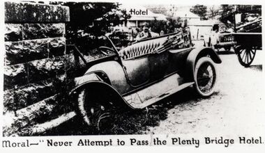
Photograph - Digital Image, Plenty Bridge Hotel 'bingle" Lower Plenty c1920, 1920s
Plenty Bridge Hotel Lower Plenty, 1920s. This photograph shows a car crashed into the pylon of the Lower Plenty Bridge with the caption "Moral - never attempt to pass the Plenty Bridge Hotel". Possibly from a newspaper, this is an advertisement for the Plenty Bridge Hotel.Digital copy of black and white photograph"Moral - never attempt to pass the Plenty Bridge Hotel"lower plenty, plenty bridge hotel, lower plenty hotel, lower plenty bridge, car accident -
 Kew Historical Society Inc
Photograph, Burke Road Bridge, 1930s
Without bridges, Kew remained cut off from the City of Melbourne, only being accessible by Punt. Private and public bridges were constructed from the 1850s, beginning with the Hawthorn Bridge linking Bridge and Burwood Roads. A bridge across the Yarra at Burke Road was created as early as 1873. Since that first wooden bridge, a number of later bridges, typically on concrete pylons have been built, in 1926 and again during the 1970s.Sepia, faded photograph of the Burke Road Bridge linking East Kew and Ivanhoe. The previous bridge, constructed in 1926 was submerged beneath the flood waters in the 1934 mega-flood of the Yarra.burke road bridge (kew), bridges -- river yarra -
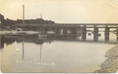 Chelsea & District Historical Society Inc
Photograph - Patterson River, Rail and Road Bridge
The first bridge over the river was built in the early 1880's, prior to this it was a pontoon bridge.Black and white photo of the road bridge (Point Nepean / Nepean Highway) and rail bridge, near the mouth of the Patterson River. Taken from the mouth of the river.patterson river, road bridge, rail bridge, chelsea, transport, patterson river bridge, carrum bridge -
 Phillip Island and District Historical Society Inc.
Photograph, Phillip Island Bridge, 1968/9
Construction of 2nd 1969 Bridge which was opened November 1969. From the Jack Jenner CollectionNew Bridge almost completed. San Remo in background with rising hill. Tractor on Bridge.local history, photographs, civil engineering, bridges, phillip island bridges, black & white photograph, jack jenner collection, public construction -
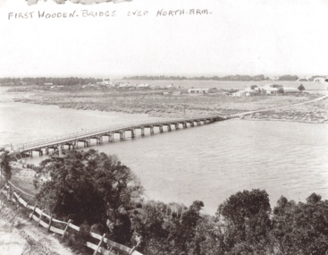 Lakes Entrance Historical Society
Photograph, Timber North Arm bridge, Lakes Entrance Victoria, 1900 c
Black and white photograph of the timber bridge over North Arm showing Club Hotel and guest houses facing front lake Lakes Entrance VictoriaFirst Wooden Bridge over North Armbridges, engineering, gippsland lakes -
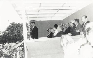 Phillip Island and District Historical Society Inc.
Photograph, Phillip Island Bridge Opening, 1969
Opening of 2nd Bridge. Speaker President Shire of Bass. This Bridge replaced the Suspension Bridge. From the Jack Jenner Collection.Opening of second Bridge 1969. Speaker, President, Shire of Basslocal history, photographs, civil engineering, bridges, opening of phillip island bridge, black & white photograph, jack jenner collection, phillip island bridges, public construction -
 Phillip Island and District Historical Society Inc.
Photograph, Phillip Island Bridge, 1968/9
Construction of 2nd 1968/69 Bridge connecting San Remo with Newhaven. From the Jack Jenner CollectionPhotograph showing two Bridges. Old Suspension Bridge on left. 1969 Bridge with all pillars in and decking completed only in foreground - taken from San Remolocal history, photographs, civil engineering, bridges, phillip island bridges, black & white photograph, jack jenner collection, public construction -
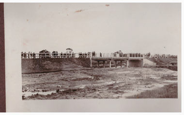 Linton and District Historical Society Inc
Photograph, Bridge Opening
Part of photograph album donated by Mrs Faull. The picture shows the opening of the Glenelg Highway Bridge over the Woady Yaloak Creek between Linton and Scarsdale.Black and white photograph of bridge opening. Bridge in background with people and cars.events, bridge openings, faull collection, woady yaloak creek -
 Falls Creek Historical Society
Photograph - Dick Stericker & Hans Fisher building bridge 1961
This item is from the private collection of George Shirling of Red Onion, Falls Creek. It depicts Dick Stericker & Hans Fisher constructing a wooden bridge. They both arrived in Falls Creek in the early 1960s. Hans worked on the slopes in summer and in winter, including building access bridges over the race-line as shown in this photograph. In 1965 Hans started as the chef Koki Alpine Lodge owned by George Shirling. He later worked as cook at various Falls Creek eating houses, as well as working for the lift company and slope maintenance People like Hans made Falls Creek. He passed away at Noosa, Queensland on 18th January 2022. George Shirling arrived in Falls Creek in 1962. He engaged Phil Nowell to build the original Koki Alpine Lodge which opened in 1965 with 14 beds. George operated the lodge with Michael “Baldy” Blackwell as manager. He also graduated in sport psychology in 1981 and was invited to become team psychologist for the Australian Winter Olympic team which went to Albertville, France, in 1992. He later owned the Red Onion Chalet. George credited the success of Koki to “Baldy” Blackwell. “Baldy” and Phil Nowell started the Trackers Mountain Lodge in partnership during the 1980s. In 1971 George sold Koki Lodge to Sigi Doerr. In 2024 the renamed Koki Alpine resort remains a highly popular destination in Falls Creek. George Shirling passed away on 27th February 2023. He had remained actively involved in Falls Creek and was generous with his time and knowledge, always an amazing supporter of The Falls Creek Museum and Falls Creek Village.This item is significant because it features two prominent members of the Falls Creek community.A black and white photograph of Dick Stericker & Hans Fisher taking a break whilst building a bridge. A typed George Shirling Collection number and description is attached. On label: ITEM NO. 148 Dick Stericker & Hans Fisher - smoko - while building bridge over raceline - Village T-bar, 1961george shirling, red onion, hans fisher -
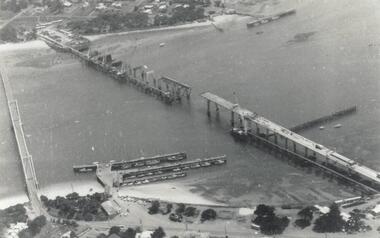
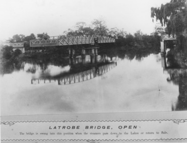 Lakes Entrance Historical Society
Photograph, Caire, Nicholas John, Swing Bridge Sale Victoria c1905, 1905c
Latrobe Bridge - Open. The bridge is swung into this position when the steamers pass down to the Lakes or return to Sale.Black and white photograph of the Latrobe River Bridge over the Latrobe River, shows the bridge open to river traffic, with a good view of the supporting structure. Sale Victoriawaterways, bridges, civil engineering -
 Eltham District Historical Society Inc
Photograph, Margaret Ball, 74 Bridge Street, Eltham, Nov-Dec 1999 now part of units 72-74 Bridge Street, 1999
The Margaret Ball (Pre 1960s Houses) Collection was a personal project initiated to mark the year 2000 and arose as a result of the disappearance of many pre-1960s parts of Eltham due to development. Approximately 200 pre-1960s style houses that were left in Eltham between Main Road and east to Bible Street, between Cecil Street to the north and south to Dalton Street were photographed in late 1999. Not all of the houses could be photographed; some because the garden or trees blocked the view of the house, others because of rubbish or cars were in the way, some because people were working on the house or in the gardens at the time.Roll of 35mm colour negative film, 7 stripsKodak GC 400-6eltham, houses, streets, margaret ball (pre 1960s houses) collection, bridge street -
 Sunbury Family History and Heritage Society Inc.
Photograph, Catanery Bridge, Bulla, c1980s
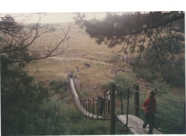
The narrow swing catanery bridge was built behind the school across the Deep Creek downstream from the bluestone Bulla Bridge. It was built so that children who lived on the south side of Bulla Township could access the school more easily and in shorter time than if they had to go by the main roads.The bridge was constructed in the days when most children walked to school. The use of this bridge cut the children's travel time and distance to school quite considerably and was used for many years until the school was closed in 1996.A coloured photograph of the children on a narrow swing bridge and the path they used to approach the bridge over open ground. bulla primary school, swing bridge, bridges, catanery bridge -
 Phillip Island and District Historical Society Inc.
Photograph - Post Card, Suspension Bridge, 1940's
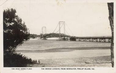
One of a collection of 18 photographs & postcards donated by Jill Yeoman. The Suspension Bridige was built during 1940. Postcard to Mrs Hughes & Lilly from Rita telling of a nice holiday visiting various towns and enjoying New Year's Eve fireworks on the Cowes beach.Black & White postcard of the Suspension Bridge from Newhaven, Phillip Island, to San Remo The Rose Series P. 2023. The bridge looking from Newhaven, Phillip Island, Vic.suspension bridge phillip island, phillip island bridge, jill yeoman -
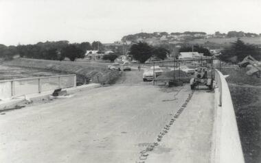
 Peterborough History Group
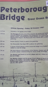
Pamphlet, Road Construction Authority, Peterborough Bridge, 1987
Printed to celebrate the official opening of the new bridge in 1987.The bridge across he river is a major access point and the old bridge had become decrepit and the construction of the new bridge was important. The official opening was a significant event.Pamphlet for the official opening of the new bridge in 1987. 2 A4 pages with a view of the old and new bridges, describing the construction of both.curdies river, great ocean road, bridges, peterborough, peterborough bridge -
 Ringwood and District Historical Society
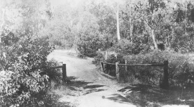
Photograph, Deep Creek bridge and road c.1935
Black and white photograph of narrow unmade road showing narrow bridge with wooded balustrades. Forested area at edge of roadway.Typed below photograph, "Deep Creek bridge and road. c.1935".