Showing 509 items
matching mining - maps
-
 Federation University Historical Collection
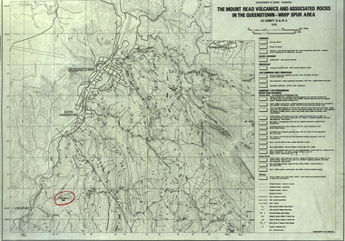
Map, The Mount Read Volcanics and Associated Rocks in the Queenstown - Whip Spur Area, 1978, 1978
Contour map of the Queenstown area in Tasmania, Australia.department of mines tasmania, volcanics, mount read, queesntown, whip spur, mining, king river, gormanston, mt owen, lynchford -
 Federation University Historical Collection
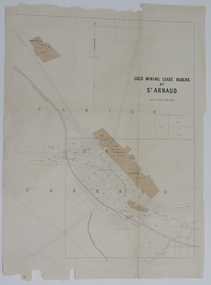
Map, Gold Mining Lease Blocks at St Arnaud, not dated
Printed map on paper with shadingst arnaud, lexell creek, st arnaud creek, wilsons hill, lord nelson -
 Federation University Historical Collection
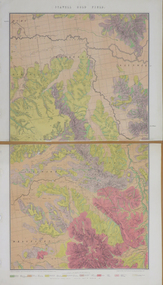
Map, Stawell, Victoria, 1878
... e.r. morris William Collard SMith Printed colour map on paper ...Printed colour map on paper, edged in masking tape stawell, e.r. morris, william collard smith -
 Federation University Historical Collection
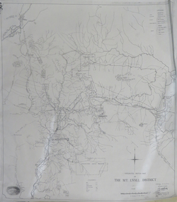
Map, Geological Sketch Map of the Mount Lyell District, 1935, 25-09-1935
Copy of a plan showing mining leases around Mount Lyell, Tasmania.mount lyell, queenstown, mining, king river -
 Federation University Historical Collection
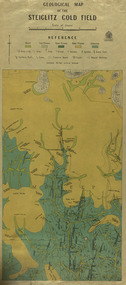
Map, Geological Map of The Stieglitz Gold Field, 1940
... Geologist. Published 1940." steiglitz geology geological map north ...At the bottom of the 2nd page, there is text that reads "Geologically and topographically surveyed in 1909 by W.H. Ferguson, Assistant Field Geologist. Published 1940."Rectangular geological map edged in masking tape showing Steiglitz, Victoria. Scale 48 chains to 4 inches.steiglitz, geology, geological map, north albion, moreep, mining, mine, caribald reef, durdidwarrah, gilbraltar hill, mount pleasant gully, township of steiglitz, w.h. ferguson, garibaldi reef, yankee gully, kinglock mine engine shaft, herbert werner frederick de nully, albion gully, virago reef, mulrooney's reef -
 Federation University Historical Collection
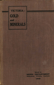
Book, Victoria: Gold and Minerals, 1935, 1935
Hard cover book. Fold out map showing auriferous areas and mineral localities in Victoria, 1935victoria, gold, minerals, 1935, geological map, hydrolic sluicing, panning, pneumatic drill, puddling machine, bendigo, coal mine, wonthaggi, yallourn, jamieson valley, geological school, melbourne university, mount buffalo, electric power station, briquette factory, mines department, george brown, secretary of mines, e.j. hogan, minister of mines, mining -
 Federation University Historical Collection
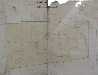
Map, No 6817 Ballaarat, Parish of Ballaarat, Mining District of Ballaarat, c1908
... mining districts mining district of ballaarat Printed map ...Printed map with pencil inscriptions on recto and versomap, mining districts, mining district of ballaarat -
 Federation University Historical Collection
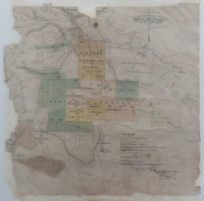
Map, Lintons Pre-emptive Section, 1872, 1872
... E.J. Barker Library (top floor) Mount Helen goldfields map ...Printed map with coloured shading by F. W Niven Lydiard Street, Ballaratmap, mining districts, lintons claim, lintons diggings, f w niven, nivens steam lithographic machine, f.w. niven -
 Federation University Historical Collection
Book, George Brown, Prospectors' Guide (Victoria), 1936, 1936
Brown soft covered book with pullout map showing auriferous areas of Victoria. prospecting, gold, geology, quartz reefs, indicators, ballarat indicators, miners' rights, mining leases, forest regulations, equipment, gold cradle, puddling machine, sluice box, whim, whip, california pump, cradle, mining, tools, mining laws -
 Federation University Historical Collection
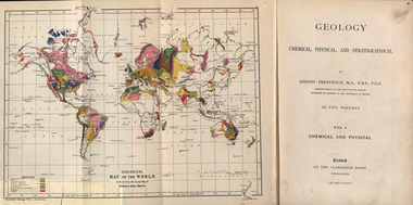
Book, Geology, Chemical, Physical, and Stratigraphical, 1886
These books were added to the library of the School of Mines Ballaarat in 1889. The author was Joseph Prestwich, who was a Professor of Geology at the University of Oxford.Two brown hard cloth covered books, Vol 1 & vol 2 with gold printing on the front cover and on the spine. .1) has a coloured fold out map of the World opposite the title page .20 has a coloured fold out map of Europe..1) A label is attached to the inside front cover with The School of Mines Ballaarat and the no. 955 and date purchased 14/3/89 (1889) as well as the institutions stamp in several places throughout the book. .2) As above but with no. 956 and on the inside fly is written in pencil 'Stamped in Error' with a Ballarat School of Mines Student Library stamp crossed out.geology, bookplate, library plate, ballarat school of mines library, joseph prestwich, geological map of the world, geological map of europe, hieropolis thermal springs, rockss, ice, volvanoes, earthquakes, metallurgy, shakespeare's cliff dover, wapley, gloucestershire, redruth mining district, fossils, reptilian footprints, chalk, london clay -
 Ringwood and District Historical Society
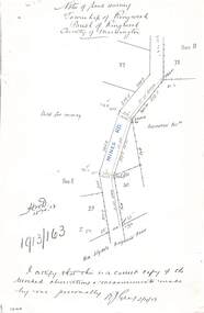
Document - Copy of Lands Department Field Notes - Township of Ringwood, Victoria, Field Notes 1913/163 - Part of O.P. R72D surveyed April 1913
5612b Foolscap size photocopy of survey map with handwritten notations. References include Mines Road, New Lilydale Road (Maroondah Highway), (area) Held for mining, Recreation Reserve, Sec D, Sec E, I certify that this is a correct copy of the recorded observations & measurements made by me personally (signed) R.J. Gray 2/4/13. -
 Bendigo Historical Society Inc.
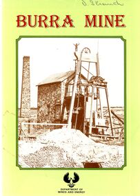
Book - STRAUCH COLLECTION: BURRA MINE
Small souvenir booklet from Burra Mine, printed by D J Woolman, Director and Government Printer, South Australia February 1987 for Department of Mines and Energy, contains photographs & maps.place, mining site, burra sa, south australia-history-mining-burra -
 Bendigo Historical Society Inc.
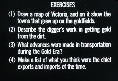
Slide - DIGGERS & MINING: THE GOLD ERA, c1850s
Diggers & mining. The gold era. Exercises (1) Draw a map of Victoria, and on it show the towns that grew up on the goldfields. (2) Describe the digger's work in getting gold from the dirt. (3) What advances were made in transportation during the Gold Era? (4) Make a list of what you think were the chief exports and imports of the time. Markings 57 994.031 GOL:5. Used as a teaching aid.hanimounteducation, tertiary, goldfields -
 Bendigo Historical Society Inc.
Slide - DIGGERS & MINING. LIFE OF THE SELECTORS, c1860
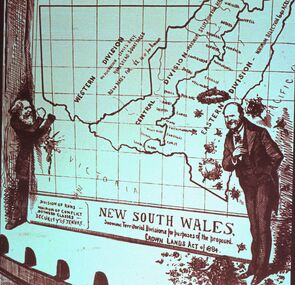
Diggers & Mining. Life Of The Selectors. Shows picture of 2 men showing large map of New South Wales marked with the new proposed divisions of NSW; West, Central and Eastern. Division between Eastern and Central run up between what may have been the major towns of NSW at the time. Leaving the Western district as pastoral for Homestead Squatters. Markings; Life Of The Selectors 1860 - 1890 Set 432 No. 15. The New Drop-Scene - ''Sydney Bulletin,'' November 10, 1883. Used as a teaching aid.Visual Education Centreeducation, tertiary, goldfields -
 Bendigo Historical Society Inc.
Slide - DIGGERS & MINING. LIFE OF THE SELECTORS, c1860
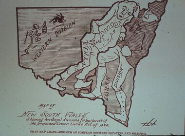
Diggers & Mining. Life Of The Selectors. Markings; Life Of The Selectors 1860 - 1890 Set 432 No. 14. That Map Again - Minimum of Conflict Between Squatter and Selector - ''Sydney Bulletin,'' October 20, 1883. Map of NEW SOUTH WALES. Showing territorial divisions for purposes of the proposed Crown Lands Act of 1883. That Map Again - Minimum of Conflict Between Squatter and Selector. There is one man drawn into each of the Eastern and Central Divisions. The Western Division is much larger and has a picture of a man with a club and a bottle of poison chasing a rabbit. Signed by Hob. Used as a teaching aid.Visual Education Centreeducation, tertiary, goldfields -
 Bendigo Historical Society Inc.
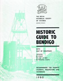
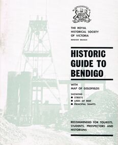
Book - HISTORIC GUIDE TO BENDIGO
A book titled ' The Royal Historical Society of Victoria Bendigo Branch, Historic Guide to Bendigo with map(Loose), of goldfields showing streets, lines of reef, principal shafts. Recommended for tourists, students, prospectors and historians. 1980.' Cambridge Press, Bendigo. Eighth Edition. Maps, photos, illustrations.bendigo, history, gold mining, book, books, bendigo history, history, victoria, victorian history, australian history, gold, gold fields, gold discoveries, place, the royal historical society of victoria bendigo branch -
 Bendigo Historical Society Inc.
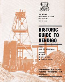
Book - HISTORIC GUIDE TO BENDIGO
Five copies of ' The Royal Historical Society of Victoria Bendigo Branch Historic Guide to Bendigo with map of goldfields showing streets, lines of reef, principal shafts. Recommended for tourists, students, prospectors and historians.' Cambridge Press, Bendigo. Third Edition. Maps, photos, illustratons. Only four copies have maps.bendigo, history, gold mining, book, books, bendigo, bendigo history, history, victorian history, victoria, australian history, gold fields, gold, gold discoveries, the royal historical society of victoria -
 Bendigo Historical Society Inc.
Book - HISTORIC GUIDE TO BENDIGO
Three books titled ' The Royal Historical Society of Victoria Bendigo Branch Historic Guide to Bendigo with map of goldfields showing streets, lines of reef, principal shafts. Recommended for tourists, students, prospectors and historicans.' Sixth Edition. Cambridge Press, Bendigo. Maps, photos, diagrams.bendigo, history, gold mining, book, books, bendigo, bendigo history, victoria, victorian history, australian history, gold, gold fields, the royal historical society of victoria, gold discoveries -
 Bendigo Historical Society Inc.
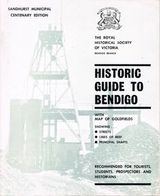
Book - HISTORIC GUIDE TO BENDIGO
A copy of a book titled 'The Royal Historical Society of Victoria Bendigo Branch Historic Guide to Bendigo with map of goldfields showing streets, lines of reef, principal shafts. Recommended for tourists, students, prospectors and historians.' Sandhurst Municipal Centenary Edition. 4th edition. Maps, photos, illustrations.bendigo, history, gold mining, book, books, bendigo, bendigo history, history, australian history, victoria, victorian history, goldfields, gold, the royal historical society of victoria -
 Bendigo Historical Society Inc.
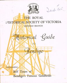
Book - HISTORICAL GUIDE TO BENDIGO
Five copies of ' The Royal Historical Society of Victoria Bendigo Branch Historical Guide to Bendigo. Including Self Tours of Bendigo's Famous Goldfields' .Cambridge Press, Bendigo.' maps, photos, illustrations. Three copies do not contain maps, however, these three copies have number stickers on the bott left front ccover, 0064.2 PAR, 0064.3 PAR, 0064.4 PAR.bendigo, history, gold mining, book, books, bendigo, bendigo history, history, gold mining, mines, the royal historical society of victoria bendigo branch, victoria, goldfields, victorian history, australian history -
 Bendigo Historical Society Inc.
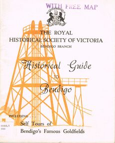
Book - HISTORICAL GUIDE TO BENDIGO
Five copies of 'The Royal Historical Society of Victoria Bendigo Branch Historical Guide to Bendigo. Including Self Tours of Bendigo's Famous Goldfields.' Revised Edition. Printed by Cambridge Press, Bendigo 1968. photos, maps, illustrations. Two copies only have WITH FREE MAP stamped on the front cover.bendigo, history, gold mining, book, books, bendigo, history, royal historical society of victoria bendigo branch, gold, goldfields, victoria, victorian history, gold mines, gold, australian history, gold discoveries, mining. sticker bottom left front cover of two copies only 0064.5 par. 0064.6 par -
 Bendigo Historical Society Inc.
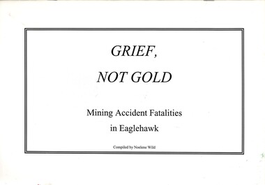
Book - STRAUCH COLLECTION - GRIEF NOT GOLD, 2001
Grief, Not Gold, Mining Accident Fatalities in Eaglehawk Compiled & published by Noelene Wild Printed by Bolton Bros Bendigo, soft cover 28 pages with a map.compiled by Noelene Wildbook, bendigo, eaglehawk, history-eaglehawk-gold mining-accidents -
 Bendigo Historical Society Inc.
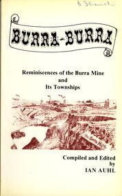
Book - STRAUCH COLLECTION: BURRA BURRA
Soft covered book titled Burra - Burra, Reminiscences of the Burra Mine and Its Townships compiled and edited by Ian Auhl, 160 pages with maps, black and white photographs & illustrations.Ian Auhlhistory, australian, burra burra, history-south australia-burra-mining -
 Bendigo Historical Society Inc.
Document - PLAN SHOWING THE VARIOUS CLAIMS ON THE NEW CHUM VICTORIA , ST MUNGO & DEVONSHIRE REEFS BENDIGO
Map of mines - calico scroll showing locations of various claims .printed in black ink on off-white Calico with turned wooden ends on scroll -missing one wooden end , some stains and creasing / Plan showing the various Claims on the New Chum Victoria , St Mungo & Devonshire reefs BendigoW Holmes , printer & lithographer , Sandhurstorganization, mining, industrial, w holmes , printer & lithographer , sandhurst/new cum , victoria st mungo & devonshire reefs bendigo -
 Bendigo Historical Society Inc.
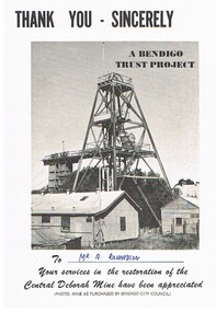
Document - CENTRAL DEBORAH MINE
5 pieces of information/advertising material for the Central Deborah Mine. A. Thankyou card presented to A. Richardson in appreciation of assistance with restoration of the mine. B&C. Diagram of the layout of the mine area, including highlights of underground tours, Key dates of the mine history and a map key to layout on the front of the pamphlet. D&E. Complimentary copy of a guide to the Central Deborah Gold Mine, showing the layout of the area and a description of each numbered site at the site. F&G. Advertising brochure, similar to the previous copy, D&E, with numbered locations at the site, and descriptions of each site. Includes additonal information re, Room 2 (change room) and Model room. H&I. Pamphlet of the mine area, showing chronological history, and short description of theach numbered site.gold mining, miners' safety cage, central deborah mine. -
 Bendigo Historical Society Inc.
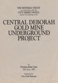
Book - JOAN O'SHEA COLLECTION: CENTRAL DEBORAH UNDERGOUND PROJECT, 20th June, 1986
Joan O'Shea Collection. Central Deborah Gold Mine Bendigo Violet Street (off High Street) Bendigo Pamphlet. Buff and Sepia double-sided A4. The Bendigo Trust in conjunction with the City Family Hotel present the opening of the Central Deborah Gold Mine Underground Project, by Premier John Cain, 20th June, 1986 featuring the City Club Dancers. Includes a brief chronological history of the mine and photographs courtesy of Phillip Beer on recto side. The verso side contains a map of the site of the Central Deborah Gold Mine and also various photographs with further detail of areas of interest including: poppet legs and shaft, the change rooms, caretakers or rag pickers room where clothing was searched, the drying room, the first aid room, carbide light room, underground tours, carpenters shed, ore bins and loading bays, stamper battery, wilfley table, berdan plans, laboratory, display room, boiler, stoke hold, winding engine, boiler feed pump, electric driven compressor, steam driven compressor and the blacksmith's shop.Central Deborah Gold Mine Bendigobendigo, gold mining, central deborah gold mine -
 Bendigo Historical Society Inc.
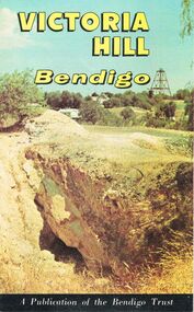
Document - JOAN O'SHEA COLLECTION: VICTORIA HILL GOLDMINING AREA BOOKLET, March 1972
Joan O'Shea Collection. Victoria Hill Bendigo Gold Mining on the Richest Quartz Reef in Bendigo, from 1854 to 1916. Colour and Black and White Booklet 16 Pages. Includes Maps of the Victoria Hill Area, photographs of the remains of a twenty head crushing battery, burnt ground from quartz roasting, The Victoria Quartz Mine Photograph from Australian Mining Standard June 1899, The compressor beds and concrete foundations for the poppet legs all that remain today of the Victoria Quartz Mine deepest mine on Bendigo Goldfield 4613 feet or 1406.04 metres. Also included photograph of the view of Victoria Hill from The New Chum Hill in the 1870s. The Location of the 3 mines Ballerstedt's open cut, North Old Chum and Lansell's 180 are marked. A depiction of Rae's Open Cut gives an understanding of the primitive nature of early workings on the Goldfields. The Booklet also provides a brief history of Victoria Hill itself.Bendigo Trust Publication March 1972. Printed in Bendigo Cambridge Press.bendigo, mining, victoria hill -
 Bendigo Historical Society Inc.
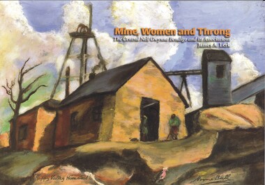
Book - MINE, WOMEN AND THRONG
Mine, Women and Throng, The Central Nell Gwynne Bendigo and its Associations, soft cover 116 pages with colour & black and white photographs, maps & graphs. Signed inside cover by author, printed by BartnPrint.James Lerkbendigo, gold mining, central nell gwynne, gold mines-gold mining victoria-bendigo-history -
 Bendigo Historical Society Inc.
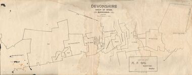
Map - DEVONSHIRE GROUP OF MINES BENDIGO
... Map showing the mining leases that include the Devonshire..., Sharebroker, Bendigo Map showing the mining leases that include ...Map showing the mining leases that include the Devonshire group of mines - leases shown from north to south are: Catherine Reef United , William United, Ellenborough, Sadowa, St. Mungo, Lady Barkly, South St. Mungo, Phoenix, United Devonshire, Duchess of Edinburgh, New St. Mungo, South Devonshire, Extended South Devonshire, New Victoria Catherine, Pearl, Hercules and Energetic.Issued by M. P. Kelly, Sharebroker, Bendigomap, bendigo, goldfields, catherine reef united , williamd united, ellenborough, sadowa, st. mungo, lady barkly, south st. mungo, phoenix, united devonshire, duchess of edinburgh, new st. mungo, south devonshire, extended south devonshire, new victoria catherine, pearl, hercules and energetic. mining, gold mines -
 Bendigo Historical Society Inc.
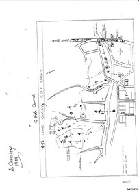
Document - LONG GULLY HISTORY GROUP COLLECTION: THE LONG GULLY GOLF LINKS
Some history of the Long Gully Golf Links, a 9 Hole Course, by John Harvey. First page has a map of the area showing where the holes are and different features. There is a description of the tees and the route taken around the course.Dates when the Eaglehawk, Neangar park, Kangaroo Flat Golf Clubs and the Long Gully Playground were opened.bendigo, history, long gully history group, the long gully history group - the long gully golf links, a crossley, john harvey, long gully rec, dai gum san reservation, quarry hill golf club, bendigo golf club, marong gulf club, miss colgan, sacred heart cathedral choir, mechanics institute, rose of australia hotel, north hercules and energetic mine site, les thomas, tom austen, pearl south mullock heap, doc catford, clubs wearne, pearl mining co's diggings, pearl south, pearl east, bill and faye osterfield, ellen lee osterfield, eaglehawk gold club, neangar park golf club, f m fitzpatrick, kangaroo flat golf club, long gully playground, pearl sands, ennor brothers, birchmore brothers, shirley harvey, belvoir park, harold ennor, george ennor