Showing 179 items
matching nunawading north
-
 Whitehorse Historical Society Inc.
Pamphlet, Neighbourhood activity in Nunawading, 1977
An attempt by the E.R.E.C. / ACCESS Community Education Project to increase the awareness of community activity and involvement in the municipality.An attempt by the E.R.E.C. / ACCESS Community Education Project to increase the awareness of community activity and involvement in the municipality. Includes maps of region showing community centres etc.An attempt by the E.R.E.C. / ACCESS Community Education Project to increase the awareness of community activity and involvement in the municipality. city of nunawading, east burwood recreation association, north blackburn community action group, vermont south community association, libraries, social services, emergency services -
Whitehorse Historical Society Inc.
Document - Documents, Slater Family
Various documents on the Slater family who came to North Blackburn in 1854. Photocopies of photos of homes in Surrey Road, Blackburn and Mitcham Grove, Nunawading. Certificate of right of burial, W.H. Slater and obituary. Census for Mitcham, Surrey. Talk by Ron Pearce, grandson of W. Slater. Medallion presented to W.H. Slater.slater family, surrey road, blackburn, no 106, mitcham grove, nunawading, slater, william henry, slater, robert, pearce, ronald harry, browning, c.t. (mrs) -
Whitehorse Historical Society Inc.
Document, Progress and Progress Associations in the 20th century, 1988
Booklet outlining the history of Progress Associations.Booklet outlining the history of Progress Associations. A Nunawading Bicentennial community project, the booklet is the first of a series of three compiled during research for a new history of Nunawading which was to be published in 1990.Booklet outlining the history of Progress Associations. clubs and associations, progress associations, blackburn north progress association, heatherdale and district progress association, mitcham and vermont progress association, blackburn progress association, nunawading progress association, vermont south community association -
Whitehorse Historical Society Inc.
Map, Springfield Road, Blackburn, 1924
Plan of subdivision, parts of Crown Portions 73 and 74, parish of Nunawading, County of Bourke.Plan of subdivision, parts of Crown Portions 73 and 74, parish of Nunawading, County of Bourke. Passed by MMBW 24 May 1924. Subdivision not implemented. Originally owned by Leonard Sherwin Bayley, then by Edward Henry Pearce, then by Ron Pearce. Part compulsorily acquired as site for Blackburn High School. With historical notes by Ron Pearce.Plan of subdivision, parts of Crown Portions 73 and 74, parish of Nunawading, County of Bourke. bayley, leonard sherwin, pearce, edward h, pearce, ronald harry, orchards, blackburn high school, north blackburn square shopping centre -
Whitehorse Historical Society Inc.
Map, Parks and recreation facilities, 1/06/1995 12:00:00 AM
Map of the City of Whitehorse with parks and reserves marked and indexedMap of the City of Whitehorse with parks and reserves marked and indexed.Map of the City of Whitehorse with parks and reserves marked and indexedcity of whitehorse, parks and reserves, bicycle paths, recreation facilities, blackburn, blackburn north, blackburn south, burwood east, forest hill, mitcham, nunawading, vermont, vermont south -
Whitehorse Historical Society Inc.
Map, City of Whitehorse, 1/03/1995 12:00:00 AM
Map of City of Whitehorse prepared by Richard Meloni showing roads, railways, creeks.Map of City of Whitehorse prepared by Richard Meloni showing roads, railways, creeks.Map of City of Whitehorse prepared by Richard Meloni showing roads, railways, creeks.blackburn, nunawading, blackburn south, mitcham, vermont, vermont south, blackburn north, forest hill, burwood east, city of whitehorse -
Whitehorse Historical Society Inc.
Map, Heritage overlay map, 1/02/1999 12:00:00 AM
... blackburn south blackburn north mitcham nunawading forest hill ...City of Whitehorse heritage review : Heritage overlay map.City of Whitehorse heritage review : Heritage overlay map.City of Whitehorse heritage review : Heritage overlay map.city of whitehorse, historic buildings, blackburn, blackburn south, blackburn north, mitcham, nunawading, forest hill, vermont, vermont south, burwood east -
Whitehorse Historical Society Inc.
Map, Shire of Blackburn and Mitcham, 1938
Plan of Shire of Blackburn and Mitcham showing sections and lot numbers. Scale 8 chains to 1 inch.Plan of Shire of Blackburn and Mitcham showing sections and lot numbers. Scale 8 chains to 1 inch.Plan of Shire of Blackburn and Mitcham showing sections and lot numbers. Scale 8 chains to 1 inch.shire of blackburn and mitcham, blackburn, blackburn north, blackburn south, burwood east, forest hill, mitcham, nunawading, vermont, vermont south -
Whitehorse Historical Society Inc.
Map, Shire of Blackburn and Mitcham, c1935
Map of Shire of Blackburn and Mitcham showing refuse collection days, sections and lot numbers. Scale 8 chains to 1 inch.Map of Shire of Blackburn and Mitcham showing refuse collection days, sections and lot numbers. Scale 8 chains to 1 inch.Map of Shire of Blackburn and Mitcham showing refuse collection days, sections and lot numbers. Scale 8 chains to 1 inch.shire of blackburn and mitcham, blackburn, blackburn north, blackburn south, burwood east, forest hill, mitcham, nunawading, vermont, vermont south -
Whitehorse Historical Society Inc.
Map, Aerial maps, 2/04/1966 12:00:00 AM
Melbourne 1966 project, runs 10A and 11A, lens 122 151.75 mm 9,800. Photo nos 77, 107, 109, 161, 163, 165.Melbourne 1966 project, runs 10A and 11A, lens 122 151.75 mm 9,800. Photo nos 77, 107, 109, 161, 163, 165. Areas and boundaries: Map no 77 W. Park and Cook Roads; E. Dubon Rd; N Oban Rd; S Reilly St. Map No 107. W. Indra Rd and Pakenham St; E. Rooks Rd & McLares Rd; N. Maroondah Hwy; S. Hawthorn Rd & Eley Rd. Map No 109 W. Elgar Rd. E. Blackburn Rd & McKean St; S. Eley Rd & Burwood Hwy. Map No 161. W. Elgar Rd & Huntingdale Rd; E. Blackburn Rd; N. Burwood Hwy; S. Waverley Rd. Map No 163. W. Blackburn Rd; S. Springvale Rd; N. Eley Rd & Hawthorn Rd; S. Glen Waverley Railway Line. Map No 165. W. Stanley Rd, Vermont South; E. Cathies Lane, Wantirna South; N. North of Burwood Hwy; S. High Street. Melbourne 1966 project, runs 10A and 11A, lens 122 151.75 mm 9,800. Photo nos 77, 107, 109, 161, 163, 165. aerial photographs, blackburn, blackburn south, forest hill, nunawading, box hill, burwood, burwood east, donvale, mount waverley, glen waverley, wantirna, vermont south, mitcham, ringwood north, ringwood -
Whitehorse Historical Society Inc.
Map, City of Nunawading, 1/02/1973 12:00:00 AM
Map of City of Nunawading shoeing open creeks or watercourses and watercourses that have been piped.Map of City of Nunawading shoeing open creeks or watercourses and watercourses that have been piped. Scale: 800 feet =1 inchMap of City of Nunawading shoeing open creeks or watercourses and watercourses that have been piped. blackburn, blackburn north, blackburn south, burwood east, forest hill, mitcham, nunawading, vermont, vermont south, city of nunawading, creeks -
Whitehorse Historical Society Inc.
Map, Shire of Blackburn and Mitcham, 10/10/1939 update
Map of Shire of Blackburn and Mitcham showing Departmental ball hydrants and departmental pillar ball hydrants.Map of Shire of Blackburn and Mitcham showing Departmental ball hydrants and departmental pillar ball hydrants. Scale 8 chains to 1 inch.Map of Shire of Blackburn and Mitcham showing Departmental ball hydrants and departmental pillar ball hydrants.shire of blackburn and mitcham, fire hydrants, blackburn, blackburn north, blackburn south, burwood east, forest hill, mitcham, nunawading, vermont, vermont south -
Whitehorse Historical Society Inc.
Map, Directory Maps of the County of Bourke, 1892
Copies of Directory maps:(i) Title Page, (ii) Preface (iii) Heading section of Map of Melbourne and Suburbs (iv) Parish of Bulleen - includes 'North - East portion of the Parish of Nunawading (v) Village of Burwood. Note: 107(a), 107(b), 107(c) are copies of the same set of sheets.Copies of:(i) Title Page, (ii) Preface (iii) Heading section of Map of Melbourne and Suburbs (iv) Parish of Bulleen - includes 'North - East portion of the Parish of Nunawading (v) Village of Burwood. Note: 107(a), 107(b), 107(c) are copies of the same set of sheets.Copies of Directory maps:(i) Title Page, (ii) Preface (iii) Heading section of Map of Melbourne and Suburbs (iv) Parish of Bulleen - includes 'North - East portion of the Parish of Nunawading (v) Village of Burwood. Note: 107(a), 107(b), 107(c) are copies of the same set of sheets.maps, parish of bulleen, parish of nunawading, burwood -
Whitehorse Historical Society Inc.
Map, Parish of Bulleen, 1892
Copy of map of the Parish of BulleenCopy of map of the Parish of Bulleen together with North-East portion of the Parish of Nunawading.Copy of map of the Parish of Bulleenmaps, parish of bulleen, parish of nunawading -
Whitehorse Historical Society Inc.
Article, It began with a herb farm 117 years ago, 1982
Article about the history of the Slater Family, whose name has been given to Nunawading's latest parkland.Article about the history of the Slater Family, whose name has been given to Nunawading's latest parkland. Robert Slater's Grandfather, William Slater, established what is believed to be the first herb farm in Australia.Article about the history of the Slater Family, whose name has been given to Nunawading's latest parkland. herb farms, parks and reserves, slater, robert, blackburn north, william, william henry, bayley, leonard sherwin, frederick -
Whitehorse Historical Society Inc.
Map, Nunawading Planning Scheme, 7/06/1994 12:00:00 AM
Local Section maps 1 - 4 with index. Geographical information system land Information Branch. Scale 1:10,000 Shows zoning under planning scheme.Local Section maps 1 - 4 with index. Geographical information system land Information Branch. Scale 1:10,000 Shows zoning under planning scheme.Local Section maps 1 - 4 with index. Geographical information system land Information Branch. Scale 1:10,000 Shows zoning under planning scheme.blackburn, blackburn north, blackburn south, forest hill, heatherdale, maps, nunawading, vermont, vermont south, town planning, burwood east, laburnum -
Whitehorse Historical Society Inc.
Article, Victory for residents, 4/08/1992 12:00:00 AM
... Katrina Street Blackburn North City of Nunawading Smith Diane ...Dangerous intersection of Koonung Road and Katrina Street .Dangerous intersection of Koonung Road and Katrina Street has finally been recognised by Nunawading Council following complaints from local residents. Steps to be taken to improve safety.Dangerous intersection of Koonung Road and Katrina Street . traffic, koonung road, blackburn north, katrina street, blackburn north, city of nunawading, smith, diane, edwards, paula, hennigan, sue, george, carol -
Whitehorse Historical Society Inc.
Letter - Correspondence, History of North Blackburn
A letter to Mr Rooney from K.A. Patterson, Nunawading and District Historical Society, enclosing their constitution.A letter to Mr Rooney from K.A. Patterson, Nunawading and District Historical Society, enclosing their constitution. The author speaks of references to hotels in Blackburn of interest to Rooney's history of North Blackburn, also talks about inspecting an old house in Almondsbury Court, Blackburn. Mrs Reynolds thought it was 120 years old but on inspection was found to be 80 - 100 years old.A letter to Mr Rooney from K.A. Patterson, Nunawading and District Historical Society, enclosing their constitution.nunawading and district historical society, rooney, keith, reynolds, (mrs), almondsbury court, blackburn. no 3 -
Whitehorse Historical Society Inc.
Book, Box Hill Reporter Cricket Association, 1994?
History of the Association, 1894 - 1994 with brief histories of some clubs.History of the Association, 1894 - 1994 with brief histories of some clubs.History of the Association, 1894 - 1994 with brief histories of some clubs.box hill reporter district cricket association, blackburn cricket club, blackburn north cricket club, blackburn south cricket club, box hill church of christ cricket club, box hill north cricket club, box hill pioneers cricket club, bulleen templestowe cricket club, burwood district cricket club, burwood heights uniting cricket club, coles myer cricket club, doncaster cricket club, east box hill cricket club, east burwood / bennettswood cricket club, eley park cricket club, forest hill cricket club, glen waverley hawks cricket club, glen waverley / northvale cricket club, heatherdale cricket club, koonung heights cricket club, mazenod old collegians cricket club, mitcham cricket club, mountain crusaders cricket club, nunawading cricket club, nunawading churches of christ cricket club, park orchards cricket club, st davids cricket club, syndal cricket club, vermont south cricket club, wheelers hill cricket club, yarraleen cricket club -
 Whitehorse Historical Society Inc.
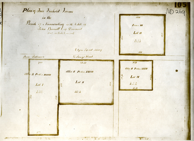
Document, Parish of Nunawading
Plan of four farms in the estate of John BarrattPlan of four farms in the estate of John Barratt on Delaneys RoadPlan of four farms in the estate of John Barratt parish of nunawading, barratt, john, delaney's road, ringwood north, elgars special survey, land subdivision -
Whitehorse Historical Society Inc.
Pamphlet, Annual Election. North East ward. Nunawading Council, 1991
... Annual Election. North East ward. Nunawading Council... Mitcham melbourne elections. city of nunawading mcphee peter ...Announcement of election 3 Aug 1991together with a list of polling places and details about candidates.Announcement of election 3 Aug 1991together with a list of polling places and details about candidates.Announcement of election 3 Aug 1991together with a list of polling places and details about candidates.elections., city of nunawading, mcphee, peter, plummer, jan -
 Whitehorse Historical Society Inc.
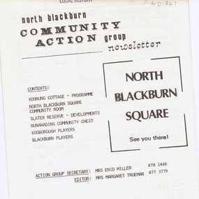
Pamphlet - Newsletter, North Blackburn Community Action Group Newsletter, No.4/10/1976|No. 6 September, 1977|No.11 July, 1979
North Blackburn Community Action GroupNorth Blackburn Community Action Group NewsletterNorth Blackburn Community Action Group miller, enid, trueman, margaret, koonung cottage, slater reserve, nunawading community chest, blackburn players, hall, doug, community groups -
 Whitehorse Historical Society Inc.
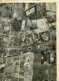
Map, Photo-map Ringwood A4A, 1945
Aerial photo covering approximately from Box Hill to Mitcham (West to East) and Springfield Road to Hawthorn Road (North to south).Aerial photo covering approximately from Box Hill to Mitcham (West to East) and Springfield Road to Hawthorn Road (North to south). Names of main roads inscribed.Aerial photo covering approximately from Box Hill to Mitcham (West to East) and Springfield Road to Hawthorn Road (North to south).aerial photographs, box hill, blackburn, nunawading, forest hill, mitcham -
Whitehorse Historical Society Inc.
Document, Whitehorse Planning Scheme, 1/05/2001 12:00:00 AM
Amendment C3 Part 2 : Panel report with extract from minutes of Whitehorse City Council recording Council's resolutions to adopt the Panel's recommendations on Heritage overlay inclusions.Amendment C3 Part 2 : Panel report with extract from minutes of Whitehorse City Council recording Council's resolutions to adopt the Panel's recommendations on Heritage overlay inclusions.Amendment C3 Part 2 : Panel report with extract from minutes of Whitehorse City Council recording Council's resolutions to adopt the Panel's recommendations on Heritage overlay inclusions.whitehorse planning scheme, historic buildings, city of whitehorse, mount pleasant road, nunawading, no 129, longland road, mitcham, no 5, strathdon orchard, australian road research board, burwood heights uniting church, boronia road, vermont, no 142, junction road, blackburn north, no 17-21, lucknow street, mitcham no 55, haines street, no 38, gordon crescent, blackburn, no 18, blackburn primary school, no. 2923 -
Whitehorse Historical Society Inc.
Newspaper - Article, Celebrating 20 years as church senior, 1/03/1991
Article in Nunawading Gazette about Rev Jack Simmonds who celebrates 20 years as senior minister with Blackburn North Baptist Church.blackburn north baptist church, simmonds, jack (rev) -
Whitehorse Historical Society Inc.
Document, History of State School 4808, Nunawading South
Document on the History of Nunawading South State School, originally established 1958.nunawading south state school no. 4808, north, reginald h., eastbridge hostel state school no. 4706 -
Whitehorse Historical Society Inc.
Document, Nunawading, a good source of clay, n.d
Notes of an interview by Pat Richardson with Ross Tucker on his experience working for Commonwealth Potteries, Blackburn North from 1937 to 1980.Notes of an interview by Pat Richardson with Ross Tucker on his experience working for Commonwealth Potteries, Blackburn North from 1937 to 1980.Notes of an interview by Pat Richardson with Ross Tucker on his experience working for Commonwealth Potteries, Blackburn North from 1937 to 1980.vitclay pipes pty ltd, commonwealth pottery pty ltd, dee brothers, tucker, ross -
Whitehorse Historical Society Inc.
Article, Council haggles over site of school, 2014
Full cost of land at $15,000,000 too high for Whitehorse Council to pay the State Government for the Nunawading Primary School site.Full cost of land at $15,000,000 too high for Whitehorse Council to pay the State Government for the Nunawading Primary School site.Full cost of land at $15,000,000 too high for Whitehorse Council to pay the State Government for the Nunawading Primary School site.nunawading primary school no. 4190, springview primary school blackburn north, whitehorse primary school, junction road, blackburn north, ellis, sharon, ryall, dee -
Whitehorse Historical Society Inc.
Article, Burnt Street Community, 2015
A group of members of St Alfred's Anglican Church in Blackburn North.A group of members of St Alfred's Anglican Church in Blackburn North, called the 'Burnt Street Community', have for the past five years made connections with Nepalese, Indian and Cambodian families living in Burnt Street.A group of members of St Alfred's Anglican Church in Blackburn North. burnt street nunawading, st. alfred's anglican church, blackburn north -
Whitehorse Historical Society Inc.
Article, Call to keep school land, 2012
Residents in Nunawading fear the land where the former Nunawading Primary School was situated will be used for residential development.Residents in Nunawading fear the land where the former Nunawading Primary School was situated will be used for residential development. They would prefer it to be open space.Residents in Nunawading fear the land where the former Nunawading Primary School was situated will be used for residential development.nunawading primary school no. 4190, daw, philip, whitehorse primary school, springview primary school blackburn north, whitehorse ratepayers and residents association