Showing 277 items
matching panoramic photograph
-
 Ringwood and District Historical Society
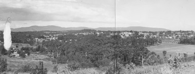
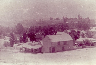
Photograph, Panoramic view of Ringwood taken from the home of Dr. Geoffrey A. Cook, Loughnan Rd., Ringwood. (No date)
... Written on back of photograph, "Panoramic view of Ringwood... Road Ringwood North melbourne Written on back of photograph ...Written on back of photograph, "Panoramic view of Ringwood taken from the home of Dr. Geoffrey A. Cook, Loughnan Rd., Ringwood. See booklet, 'Welcome to Ringwood' 1948 or 49' - H.J. Pearson Mayor". -
 Kew Historical Society Inc
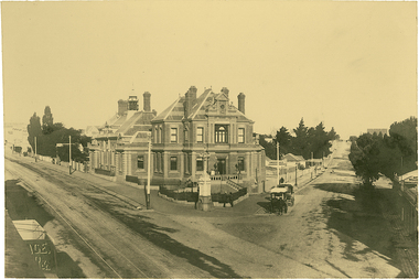
Photograph, J F C Farquhar, The Post Office, 1891
... A panoramic photograph of the junction of High Street... The Post Office A panoramic photograph of the junction of High ...At the beginning of the 1890s, the Kew businessman and Town Councillor, Henry Kellett, commissioned J.F.C. Farquhar to photograph scenes of Kew. These scenes included panoramas as well as pastoral scenes. The resulting set of twelve photographs was assembled in an album, Kew Where We Live, from which customers could select images for purchase.The preamble to the album describes that the photographs used the ‘argentic bromide’ process, now more commonly known as the gelatine silver process. This form of dry plate photography allowed for the negatives to be kept for weeks before processing, hence its value in landscape photography. The resulting images were considered to be finely grained and everlasting. Evidence of the success of Henry Kellett’s venture can be seen today, in that some of the photographs are held in national collections.It is believed that the Kew Historical Society’s copy of the Kellett album is unique and that the photographs in the book were the first copies taken from the original plates. It is the first and most important series of images produced about Kew. The individual images have proved essential in identifying buildings and places of heritage value in the district.A panoramic photograph of the junction of High Street and Cotham Road. The photographer centres the point-of-view on the Kew Post Office and adjacent Court House. These were designed in the Queen Anne style by the Public Works Department's architect J Harvey and completed in 1888. The complex is important because it demonstrates a departure from the contemporaneously favoured High Victorian Classical to the Queen Anne style in the design of civic buildings. The earlier Jubilee Fountain in front of the Post Office was erected by the Kew Borough Council to commemorate the Golden Jubilee of Queen Victoria in 1887. It was created to a design of the architects Reed, Henderson and Smart. The fountain was later relocated to the Alexandra Gardens to make way for the Kew War Memorial. The tram tracks in High Street were used by the horse tram, which ran from the Victoria Street Bridge to the Boroondara General Cemetery. The tram was replaced by an electrified service in 1915.The Post Officekew post office, kew illustrated, kew where we live, photographic books, henry kellett -
 Kew Historical Society Inc
Photograph, J F C Farquhar, Railway Bridge Over the Yarra, 1891
... for vehicular traffic. In 1891 when this panoramic photograph was taken.... In 1891 when this panoramic photograph was taken, the grounds ...At the beginning of the 1890s, the Kew businessman and Town Councillor, Henry Kellett, commissioned J.F.C. Farquhar to photograph scenes of Kew. These scenes included panoramas as well as pastoral scenes. The resulting set of twelve photographs was assembled in an album, Kew Where We Live, from which customers could select images for purchase.The preamble to the album describes that the photographs used the ‘argentic bromide’ process, now more commonly known as the gelatine silver process. This form of dry plate photography allowed for the negatives to be kept for weeks before processing, hence its value in landscape photography. The resulting images were considered to be finely grained and everlasting. Evidence of the success of Henry Kellett’s venture can be seen today, in that some of the photographs are held in national collections.It is believed that the Kew Historical Society’s copy of the Kellett album is unique and that the photographs in the book were the first copies taken from the original plates. It is the first and most important series of images produced about Kew. The individual images have proved essential in identifying buildings and places of heritage value in the district.Completed in November 1890, the railway viaduct (now the Chandler Highway Bridge) linked Kew and Fairfield. The viaduct is significant as the most substantial extant engineering remnant of the Outer Circle Railway Line. Opened in March 1891, the viaduct crossed the Yarra River in a single span, atop three supporting brick pillars. Following the closure of the railway line in 1927, and the construction of the Chandler Highway in 1930, the bridge was used for vehicular traffic. In 1891 when this panoramic photograph was taken, the grounds of what was then the Kew Lunatic Asylum extended down to the River and eastward beyond the viaduct. The landscape surrounding the Asylum was planted with traditional exotic trees such as Oaks, Pines and Cedars, and landmark trees from northern Australia such as the Hoop Pine. Remnant indigenous trees such as the River Red Gum, Yellow Box and Lightwood were scattered around the site, including beside the Yarra River.Railway Bridge Over the Yarrakew illustrated, kew where we live, photographic books, henry kellett, railway viaduct - - kew (vic) -
 Kew Historical Society Inc
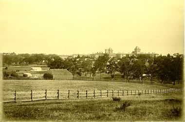
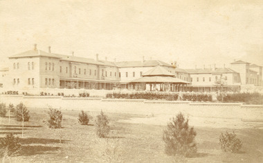
Photograph, J F C Farquhar, Kew Asylum & Grounds, 1891
... by Farquhar for this panoramic photograph focuses on the ordered open...-of-view chosen by Farquhar for this panoramic photograph focuses ...At the beginning of the 1890s, the Kew businessman and Town Councillor, Henry Kellett, commissioned J.F.C. Farquhar to photograph scenes of Kew. These scenes included panoramas as well as pastoral scenes. The resulting set of twelve photographs was assembled in an album, Kew Where We Live, from which customers could select images for purchase.The preamble to the album describes that the photographs used the ‘argentic bromide’ process, now more commonly known as the gelatine silver process. This form of dry plate photography allowed for the negatives to be kept for weeks before processing, hence its value in landscape photography. The resulting images were considered to be finely grained and everlasting. Evidence of the success of Henry Kellett’s venture can be seen today, in that some of the photographs are held in national collections.It is believed that the Kew Historical Society’s copy of the Kellett album is unique and that the photographs in the book were the first copies taken from the original plates. It is the first and most important series of images produced about Kew. The individual images have proved essential in identifying buildings and places of heritage value in the district.When the Kew Lunatic Asylum was opened in 1871, its extensive 340 acres of grounds were intended for farming, agriculture and recreation for the inmates. The point-of-view chosen by Farquhar for this panoramic photograph focuses on the ordered open fields, haystacks and remnant trees that extended from the foreground to the rear of the Asylum. The inmates are the absent players in this pastoral idyll. In 1891, The Argus reported on the Annual Asylum Picnic: “Wednesday saw the Kew picnic, the yearly festival of the mad folks and their keepers. Once a year the public subscribes for cakes and ale for all these mad folks, and their keepers, from superintendent to lowest wardsman, turn out, and use their best endeavours to make one day in the year sanely merry.” Regardless of such merriment, the Asylum’s development and ongoing status were frequently a source of disquiet to the residents of Kew, who regularly petitioned the State Government for its removal. Despite these views, the Asylum was to remain a functioning institution from 1871 to 1988. Kew Asylum & Groundskew illustrated, kew where we live, photographic books, henry kellett, kew lunatic asylum -
 Phillip Island and District Historical Society Inc.
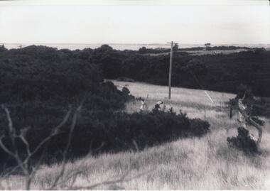
Photographs, Gary Field, 1963
... Four black & white photographs of panoramic views from... 1960's gary field Four black & white photographs of panoramic ...Photographs taken by Gary Field. Lady in photos is Gary's mother. She planted Angophora trees near corner of Daffyd Street and Appley Avenue. (Information supplies by John Eddy).Four black & white photographs of panoramic views from and of Daffyd Street, Red Rocks in 1963, looking north with French Island and the Peninsula on the horizon, view of houses and caravans in Daffyd Street and showing local scrub and housing.daffyd street red rocks, red rocks phillip island, houses 1960's, gary field -
 Clunes Museum
Photograph
... .1 BLACK AND WHITE PHOTOGRAPH PANORAMIC VIEW FROM BAILEY... BLACK AND WHITE PHOTOGRAPH PANORAMIC VIEW FROM BAILEY STREET ...ORIGINAL PHOTOGRAPH ON LOAN FOR COPYING FROM MRS. MARSHALLSEA..1 BLACK AND WHITE PHOTOGRAPH PANORAMIC VIEW FROM BAILEY STREET CLUNES LOOKING NORTH TOWARDS CLUNES HIGHER ELEMENTARY SCHOOL NO 1552, CANTERBURY STREET. TURNBULL'S PRODUCE STORE IN FOREGROUND CORNER BAILEY AND TEMPLETON STREET. .2 .3 BLACK AND WHITE COPIES OF THE ABOVE PHOTOGRAPH PRINTED ON GLOSS PHOTOGRAPHIC PAPERphotography, shops turnbulls produce store, buildings -
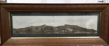
 Ringwood and District Historical Society
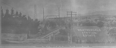
Photograph, View from where Heatherdale railway station is now situated, looking towards Ringwood - 2/2/1924. Land between Heatherdale Rd. and Madden St., sold 2nd Feb. 1924. J.B. McAlpin - agent"
... Typed at bottom of photograph, "Panoramic view of Ringwood... Road Ringwood North melbourne Typed at bottom of photograph ...Typed at bottom of photograph, "Panoramic view of Ringwood and the mountains, from Heatherdale Station Estate". Typed below photograph on mounting sheet, "View from where Heatherdale railway station is now looking towards Ringwood - 2/2/1924". "Between Heatherdale Rd. and Madden St., sold 2nd Feb. 1924. J.B. McAlpin - agent". -
 Ringwood and District Historical Society
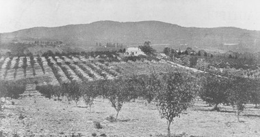
Photograph, View from Canterbury Road/Balfour Avenue area overlooking Martell's orchard, Heathmont, 1929
... Typed below photograph, "Panoramic view taken on the estate... Road Ringwood North melbourne Typed below photograph ...Black and white photograph of orchard. House in middle range, mountains in background. Photograph appears to be reproduced from subdivisional brochure. Note inserted in sleeve reads, "It has been pointed out that the mountains are to the east and the view is looking south. This therefore is not a 'straight' photograph. House still exists in Eden Avenue at October, 1996".(3 copies).Typed below photograph, "Panoramic view taken on the estate". "View overlooking Martell's orchard, Heathmont, 1929". Taken from corner Canterbury Rd. and Balfour Ave. looking south. Dandenong Creek just beyond house. Washusen Rd. on right". Written on back of one of the copies, "Heathmont Station Estate 1922". "Station Street, Lisgoold St. Canterbury Rd. Vivienne Cres. Balfour Ave." -
 National Wool Museum
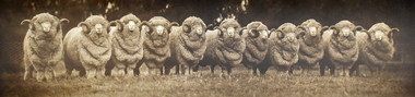
Photograph - The Australian Eleven, 1935
... Panoramic black and white photograph of eleven merino rams... Industry - history Panoramic black and white photograph of eleven ..."The Australian Eleven", from the display board which hung in the Geelong Wool Exchange, Corio St, Geelong until the building was sold in 1985. Sheep were from the "Wanganella" station in Victoria.Panoramic black and white photograph of eleven merino rams in full fleece, standing in a row in front of a wire fence. The photograph has a dark, tree-lined background and each side has been blackened out. Photograph is glued to cream cardboard. Bands of glue are visible where photograph has been fixed to mounting board. Grey paper pieces glued to the back of the cream board.merino sheep, sheep australian, pastoral industry history, geelong woolbrokers' association geelong wool exchange, western district, victoria, 'wanganella' victoria, sheep - australian, pastoral industry - history -
 Kew Historical Society Inc
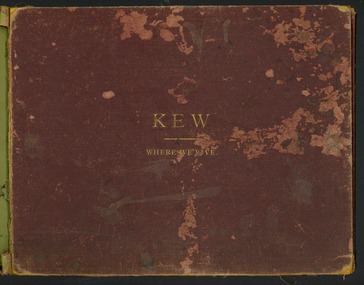
Book, Henry de Castres Kellett BT, Kew Where We Live : Kew Illustrated, 1891
... plates of panoramic and landscape photographs of Kew... of panoramic and landscape photographs of Kew, commissioned from ...At the beginning of the 1890s, the Kew businessman and Town Councillor, Henry Kellett, commissioned J.F.C. Farquhar to photograph scenes of Kew. These scenes included panoramas as well as pastoral scenes. The resulting set of twelve photographs was assembled in an album, Kew Where We Live, from which customers could select images for purchase.The preamble to the album describes that the photographs used the ‘argentic bromide’ process, now more commonly known as the gelatine silver process. This form of dry plate photography allowed for the negatives to be kept for weeks before processing, hence its value in landscape photography. The resulting images were considered to be finely grained and everlasting. Evidence of the success of Henry Kellett’s venture can be seen today, in that some of the photographs are held in national collections.It is believed that the Kew Historical Society’s copy of the Kellett album is unique and that the photographs in the book were the first copies taken from the original plates. It is the first and most important series of images produced about Kew. The individual images have proved essential in identifying buildings and places of heritage value in the district.A unique Illustrated book, comprising a series of twelve plates of panoramic and landscape photographs of Kew, commissioned from the Melbourne (and Kew) photographer JFC Farquhar, by the Kew stationer Henry Kellett. The book was published in 1891, so it is presumed that the photographs provided by Farquhar were taken in 1891 or in the previous year. Photographs from the cloth bound book were offered by Kellett for sale separately; hence a number are in public collections. The book is in very poor condition, the leaves having separated from the spine. The cover is suffering from red rot while the mounts of each book plate are dirty and frequently suffering from foxing. The actual silver albumen plates variably suffer from foxing and iridescence caused by the deterioration resulting from the photographic process. Each part of the book can be viewed in this record in sequential format.KEW WHERE WE LIVE / KEW ILLUSTRATED / THE ACCOMPANYING ILLUSTRATIONS ARE PHOTOGRAPHIC VIEWS OF KEW AND ITS SURROUNDINGS, EXECUTED BY THE "ARGENTIC BROMIDE PROCESS", WHICH ENSURES ABSOLUTE PERMANENCY OF THE PHOTOGRAPH. IN A FEW YEARS HENCE WHEN MOST OF THE OLD LANDMARKS WILL HAVE DISAPPEARED THESE VIEWS WILL BE A VALUABLE MEMENTO OF KEW AS IT WAS IN 1891. ANY OF THESE ILLUSTRATIONS GAN BE OBTAINED FROM MR. H. KELLETT, HIGH STREET, KEW, IN SINGLE COPIES, IN THE SAME SIZE AS THOSE HEREIN AT 2s PER COPY. THEY MAY ALSO BE OBTAINED IN THE FOLLOWING SIZES FOR FRAMING:- / ACTUAL SIZE OF PHOTOGRAPH 15 INCHES X 12 INCHES @ 8. 6d EACH / 22 INCHES X 16 INCHES @ 15s EACH / PRIVATE RESIDENCES AND ESTATES / SPECIAL ARRANGEMENTS CAN BE MADE FOR TAKING VIEWS OF PRIVATE RESIDENCES - INTERIOR AND EXTERIOR - AND FOR GROUPS, &C., IN ANY SIZE UP TO 40 INCHES BY 30 INCHES BY THE "ARGENTIC BROMIDE" PROCESS UPON APPLICATION TO / MR H. KELLETT / HIGH STREET, KEW.kew illustrated, kew where we live, photographic books, henry kellett, jfc farquhar - photographer -
 The Beechworth Burke Museum
Photograph, Bayless C. - Manager, 1875
In this photo, taken in around 1875, is depicted the exterior of the Beechworth Mental Asylum buildings, with the administration buildings far right of the photo. A sunken boundary wall in the foreground and some people in view, sitting at the pavillion in the centre of the image. The two-storey buildings, designed in Italianate style, and the three-storey towers at the front, influenced by the asylum at Colney Hatch in England. The architecture of the buildings shares key features with other contemporary institutions, like Aradale at Ararat, and its design is attributed to the Public Works Department architect, J.J. Clark, whose name is connected with the construction of many other important public buildings, such as the Asylums at Kew and Ararat, the front block of the Royal Mint, Melbourne and the Melbourne Customs House. The Mayday Hills Hospital was constructed between 1864 and 1867, with buildings created in a number of periods. It formally opened on 24 October 1867 and, along with the Ovens Hospital and the Benevolent Asylum, made Beechworth a prominent social welfare centre in Victoria. Large masses of granite were excavated for its foundation and around 250 workmen were employed for its construction. The building, divided into six sections, was comprised of dormitories, doctors` rooms and plenty ancillary rooms and facilities, such as laundries, reading rooms, a concert hall and cooking areas. The site was chosen for its panoramic view of the countryside, the hilltop atmosphere and the native fauna, all contributing to the cure of patients. The Hospital was originally named the “Ovens Lunatic Asylum” but during the centenary celebrations in 1967 the name was officially changed to “Mayday Hills Hospital”, showing the gradual shift in the perception and understanding of mental health conditions over the last decades. The Hospital lies on the traditional land of the Kulin Nation.This photograph is historically significant as it provides an insight into the location, surroundings and the exterior of the Mayday Hills Hospital at the end of the 19th century. It also contributes to the understanding of the district`s development and its importance to the course of Victoria`s history and is acknowledged as a unique construction, being one of three identified as the largest of their kind.Black and white rectangular photograph printed on matte photographic paper mounted on board.Reverse: 37/ 3443/ Beechworth Asylum about 1875/ American & Australasian/Photographic Company/Victoria Branch./C.Bayless, Manager./ No./beechworth mental asylum, aradale, public works department, j.j. clark, melbourne customs house, colney hatch, italianate style, mayday hills hospital, royal mint, granite, benevolent asylum, dormitories, ovens lunatic asylum, ancillary rooms, centenary celebrations, three-storey towers, countryside, mental health conditions, kulin nation, concert hall -
 The Beechworth Burke Museum
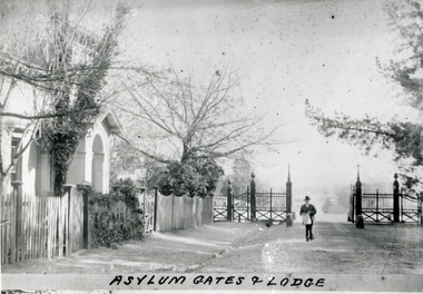
Photograph - Photograph Reproduction, 1890
The photo is taken in 1890 and a man is depicted, entering the main gates of the Mental Hospital at Beechworth, with the lodge on his right side. The man is dressed according to the australian fashion of that time, wearing a dark suit and a top hat. The countryside surrounding the Hospital is in the background. The Mayday Hills Hospital was constructed between 1864 and 1867, with buildings created in a number of periods. It formally opened on 24 October 1867 and, along with the Ovens Hospital and the Benevolent Asylum, made Beechworth a prominent social welfare centre in Victoria. The need for an institution of this kind was arisen due to the increased number of people with mental disturbances (induced by the harsh living conditions on the goldfields) and the remoteness of the district from Melbourne. The site was chosen for its panoramic view of the countryside, the hilltop atmosphere and the native fauna, all contributing to the cure of patients. It was designed in Italianate style and around 250 workmen were employed for its construction. The Hospital was originally named the “Ovens Lunatic Asylum” but, during the centenary celebrations in 1967, the name was officially changed to “Mayday Hills Hospital”, showing the gradual shift in the perception and understanding of mental health conditions over the last decades. The Hospital lies on the traditional land of the Kulin Nation.This photograph is historically significant as it provides an insight into the location, surroundings and the exterior of the Mayday Hills Hospital at the end of the 19th century. It also contributes to the understanding of the district`s development and its importance to the course of Victoria`s history. Moreover, it adds information to the scientific research and the way mental health conditions were treated at that time.Black and white rectangular photograph printed on paper unframed.Obverse: Asylum Gates & Lodge/ Reverse: 3451-1/mental hospital, beechworth, australian fashion, dark suit, top hat, countryside, mayday hills hospital, ovens hospital, benevolent asylum, institution, mental disturbances, social welfare, living conditions, goldfields, workmen, italianate style, kulin nation, mental health, ovens lunatic asylum, patients -
 The Beechworth Burke Museum
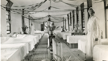
Photograph, 1934
The photo is taken in 1934 and illustrates the internal view of a ward in the Mental Hospital at Beechworth. Some patients in beds and three nurses are in view. Beds were arranged in lines alongside the walls and there were no partitions or screens to create privacy for patients. Furniture was simple and humble; bed frames were made of metal or wood and pillowcases and covers for the attendant`s tables were sometimes made of blue-striped canvas or calico. Large windows in the walls were offering ample light and the room was well-tended, with Christmas decoration, flowers, pots and carpets on the floor. The nurse in the foreground is Miss Neary. The Mayday Hills Hospital was constructed between 1864 and 1867, with buildings created in a number of periods. It formally opened on 24 October 1867 and, along with the Ovens Hospital and the Benevolent Asylum, made Beechworth a prominent social welfare centre in Victoria. The need for an institution of this kind was arisen due to the increased number of people with mental disturbances (induced by the harsh living conditions on the goldfields) and the remoteness of the district from Melbourne. The site was chosen for its panoramic view of the countryside, the hilltop atmosphere and the native fauna, all contributing to the cure of patients. The Hospital was originally named the “Ovens Lunatic Asylum” but, during the centenary celebrations in 1967, the name was officially changed to “Mayday Hills Hospital”, showing the gradual shift in the perception and understanding of mental health conditions over the last decades. The Hospital lies on the traditional land of the Kulin Nation. This photograph is historically significant as it provides an insight into the living conditions of patients admitted to the Mayday Hills Hospital at the beginning of the 20th century. It also contributes to the understanding of the district`s development and its importance to the course of Victoria`s history. Additionally, it provides important information about the way mental health conditions were perceived at that time and how patients were treated. Black and white rectangular photograph printed on paper. Reverse: 1997.2665/ To Miss JA.Peach/ [hallmark: Printed by Harringtons]/ With best wishes/from/H.Jeanes/for 1934.mayday hills hospital, benevolent asylum, ovens hospital, ovens lunatic asylum, kulin nation, beechworth, patients, nurse, social welfare, goldfields, melbourne, mental health, living conditions, blue-striped canvas, calico, bed frames, miss neary, mental disturbances, traditional land, centenary celebrations -
 The Beechworth Burke Museum
Photograph - Photograph Reproduction, 1870
The photograph is a copy of the original one, with the latter been captured in 1870. The man depicted is Doctor Thomas Thomson Dick, who was the first Medical Superintendent at Mayday Hills Hospital. He was born in Scotland in 1840 and he died in East Malvern in 1919. He obtained his degree of Doctor of Medicine from Melbourne University in 1864 and, later in his career, he became Inspector-General of the mentally ill. Dr Dick promoted the hospital`s self-sufficiency by engaging patients in various forms of work, such as clothing alterations and cultivation of the farm. He also introduced monthly balls, which could be attended by patients, staff and guests, and they were later replaced by concerts. The Mayday Hills Hospital was constructed between 1864 and 1867, with buildings created in a number of periods. It formally opened on 24 October 1867 and, along with the Ovens Hospital and the Benevolent Asylum, made Beechworth a prominent social welfare centre in Victoria. The need for an institution of this kind was arisen due to the increased number of people with mental disturbances (induced by the harsh living conditions on the goldfields) and the remoteness of the district from Melbourne. The site was chosen for its panoramic view of the countryside, the hilltop atmosphere and the native fauna, all contributing to the cure of patients.The Hospital was originally named the “Ovens Lunatic Asylum” but, during the centenary celebrations in 1967, the name was officially changed to “Mayday Hills Hospital”, showing the gradual shift in the perception and understanding of mental health conditions over the last decades. The Hospital lies on the traditional land of the Kulin Nation.This photograph is historically significant as it provides information about the staff served at the Mayday Hills Hospital when it first opened. It also contributes to the understanding of the district`s development and its importance to the course of Victoria`s history and adds valuable information about the changing approaches to the treatment of mental health conditions.Black and white rectangular photograph printed on paper.Obverse: (7)/ Reverse: 1997.2452/ Dr Dick/No(7) Pioneer Board/doctor thomas thomson dick, superintendent, mayday hills hospital, scotland, east malvern, doctor of medicine, melbourne university, inspector-general, clothing alterations, cultivation of the farm, self-sufficiency, balls, concerts, ovens hospital, benevolent asylum, beechworth, goldfields, kulin nation, panoramic view, mental health conditions -
 The Beechworth Burke Museum
Photograph - Photograph Reproduction, 1998
The photograph, created in 1998, is a copy of the original one, depicting a nurse in uniform at the Mental Hospital in Beechworth, with a fern house behind her. In the background, the two-storey building is in view, along with the covered walkway. The institution had to operate with serious shortage of female nurses for long periods of time. During the 1880s, small houses (cottages) were built to offer accommodation for the nurses living in the hospital and in 1937 began the construction of a nurses` hostel. In 1962 the upper level of the Nurses` Home was converted into a Nurses` Training School. The Mayday Hills Hospital was constructed between 1864 and 1867, with buildings created in a number of periods. It formally opened on 24 October 1867 and, along with the Ovens Hospital and the Benevolent Asylum, made Beechworth a prominent social welfare centre in Victoria. The need for an institution of this kind was arisen due to the increased number of people with mental disturbances (induced by the harsh living conditions on the goldfields) and the remoteness of the district from Melbourne. The two-storey buildings, designed in Italianate style, and the three-storey towers at the front, were influenced by the asylum at Colney Hatch in England. Large masses of granite were excavated for its foundation and around 250 workmen were employed for its construction. The building, divided into six sections, was comprised of dormitories, doctors` rooms and plenty ancillary rooms and facilities, such as laundries, reading rooms, a concert hall and cooking areas. The site was chosen for its panoramic view of the countryside, the hilltop atmosphere and the native fauna, all contributing to the cure of patients. The Hospital was originally named the “Ovens Lunatic Asylum” but, during the centenary celebrations in 1967, the name was officially changed to “Mayday Hills Hospital”, showing the gradual shift in the perception and understanding of mental health conditions over the last decades. The Hospital lies on the traditional land of the Kulin Nation.This photograph is historically significant as it provides an insight into the everyday life of staff living within the walls of the Mayday Hills Hospital. It also offers important information about the location and the exterior of the Hospital and contributes to the understanding of the district`s development and its importance to the course of Victoria`s history.Black and white rectangular photograph printed on paper unframed.Reverse: 3445/mental hospital, beechworth, fern house, female nurses, nurses` home, nurses` training school, nurses` hostel, mayday hills hospital, ovens hospital, colney hatch, two-storey buildings, italianate style, benevolent asylum, ovens lunatic asylum, kulin nation, workmen, covered walkway, granite, hilltop atmosphere, mental health -
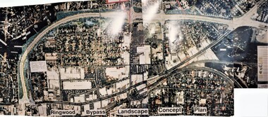 Ringwood and District Historical Society
Photograph, Ringwood Bypass Landscape Concept Plan
Three colour phototraphs forming composite panoramic aerial view (undated)."Ringwood Bypass Landscape Concept Plan" -
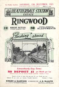 Ringwood and District Historical Society
Flyer, Subdivisional Land Auction Sale Brochures, Heatherdale Station Estate, Ringwood, Vic. - 1923 and 1924
Two double sided multi-folded pages advertising public auction sales of shop sites and residential allotments on Saturday, 15th December, 1923 and Saturday, 2nd February, 1924, including summary of local facilities, services and map showing layout of the estate. Includes a photograph depicting proposed site for first Heatherdale railway station and a panoramic view of Ringwood from the railway level crossing in Heatherdale Road. 1923 and 1924 flyers are identical except for the auction dates printed at the top.Subdivision includes Heatherdale Road, Molan Street, Yallourn Parade, Newman Street, and Madden Street. Agents - Knight & Harwood, 315 Collins Street, Melbourne, Phone 10615, 10616 Central, in conjunction with J.B. McAlpin, Opposite Railway Station, Ringwood. Phone Ringwood 7. -
 Bendigo Military Museum
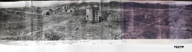
Photograph - PANORAMIC PHOTO OF BOMBED HIROSHIMA, C. 1945/46
... . Photograph PANORAMIC PHOTO OF BOMBED HIROSHIMA. ...Compared to photos in AWM collection, this photo appears to have been taken August 1945 to Feb 1946. Item is part of the BCOF Association Collection, refer Cat No 7625.This is a wide black and white panorama of a severely bomb damaged city. It is composed of five separate photos joined together. At the bottom are Japanese characters/writing. They have a dot beside each sentence. There are no English subtitles.ww2, atomic warfare, hiroshima -
 Warrnambool and District Historical Society Inc.
Frame Fragment, Frame Fragment from 1860 J Wilder, Late 19th century
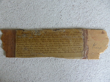
Joseph Wilder, a professional photographer, came to Warrnambool in 1860 and took a series of photographs, two of which survive today. One was of the local Volunteer Corps and the other was a series of photographs taken from Cannon Hill showing Merri Street and the town and buildings beyond. It seems that copies of these last-mentioned photographs were framed to produce a large panoramic view of 1860 Warrnambool and one of these was given to the old Warrnambool Museum in the 1880s by James Astley Bromfield. He had established a chemist’s shop in Warrnambool in 1854 and showed his interest in the history of the young town by producing a map in 1856 showing the first landowners, a seminal resource today for historians. He again demonstrated this interest when he included the names of the people and places in the 1860 photograph he gave to the museum in the 1880s. The frame fragment was found amongst the collection of items from the old Museum at Flagstaff Hill Maritime Museum and brought to the Historical Society to accompany the original series of photographs. Bromfield went to live in Melbourne in the 1880s. It is presumed that the plastic cover has been placed on the frame fragment at a much later date than the 1880s.This frame fragment is interesting and very important for several reasons:- 1. It is one demonstration of the interest that James Astley Bromfield had in local history 2. It came from the old Warrnambool Museum and shows how that institution kept items of historical interest 3. It gives us the names of the people and places in the Joseph Wilder photographs of 1860 that placed together form a panorama that reveals what a major section of Warrnambool looked like only 13 years after its foundation. The list enables us to correctly identify the early places and people and so is invaluable for research purposes 4. It links a Museum exhibit of the 1880s with the original 1860 photographs which are held by the Historical Society This is a piece of wood broken from a frame containing a photograph. It has jagged edges. It contains the list of people and places depicted in the Joseph Wilder panorama photograph of Warrnambool in 1860. The list is handwritten in ink on paper which has been attached to the frame with a piece of plastic. Warrnambool in 1860 Photographed by Wilder. Showing children of the late Andrew Semple etc In red pencil – ‘Keep’, in ink, ‘Keep’ On separate piece of paper - Presented to Warrnambool Mechanics’ Muzeum by James Astley Bromfield, August 3rd 1886 joseph wilder 1860, panorama of warrnambool -
 Kiewa Valley Historical Society
Photographs –Collection of 10 copies and original black and white photographs and printed articles relating to skiing on the Bogong High Plains
After World War II, the Kiewa Hydro-Electric Scheme was started in the Kiewa River Valley by the State Electricity Commission of Victoria. On land previously used only for summer cattle grazing in the natural alpine grasslands, the first ski lodge was built in 1948 by workers from the hydro scheme as skiing was a popular recreation. Many of the hydro employees were of European background and had grown up enjoying skiing and snow sports in their homelands and were keen to continue to pursue their winter sports interests. The first lift, a rope tow, was built in 1951 at Falls Creek and the first chairlift in Australia was constructed there in 1957. Two T-Bars were opened in 1961. In 1964, the Victorian Municipal Directory recorded that Falls Creek had 29 ski club lodges and 16 commercial lodges. The area became a popular tourist destination for both winter and summer sports.: Employees of the State Electricity Commission of Victoria in the Kiewa River Valley were the earliest skiers on the Bogong High Plains and built one of the first ski lodges at Falls Creek. They were amongst those pivotal in the development of the skiing and tourist industry at Falls Creek and on the Bogong High Plains. Collection of 10 copies and original black and white photographs and printed articles relating to skiing on the Bogong High Plains. Some pieces have been enlarged to A3 poster size copies for display purposes 1. Copy of black and white photograph of group of skiers at Falls Creek 2. Copy of photograph of early skier on Bogong High Plains with temporary buildings and tents in the background 3. Copy of photograph of 3 skiers on Mt McKay 4. Copy of SECV photograph of Rocky Valley Camp under snow 5. Early sepia photograph of Falls Creek village with skiers in the foreground 6. Copy of a page from booklet (SECV?) promoting the benefits of owning a holiday home in the Bogong Village area 7. Copy of a page from booklet (SECV?) promoting the benefits of holidaying in and around Falls Creek/Mt Beauty 8. Panoramic view of ski fields with skis in the foreground 9. Photograph of young skier (identity unknown) 10. Photograph of 2 male skiers (identity unknown) performing a small jump 1. Bogong Ski Club Members & Friends 1944 2. Jack Neve – electrician. Rocky Valley 3. 17.5.55 Skiers ascending Mt McKay 4. State Electricity Commission of Victoria. Date:17.8.55 No:K8132 Kiewa Hydro Electric Works. Rocky Valley Camp – From Engineering Office 5 & 9 No markings 6 & 7 Short article relating to photos on each page 8. Handwritten signature on rear of photo (Sandra Conea) 10 Faded unreadable photographers stamp and handwritten numbers 6875 on rear secv; bogong high plains; skiers; falls creek; tourism -
 Kiewa Valley Historical Society
Postcard Circa 1950, Snow Plough, Bogong High Plain,5,500 Feet Kiewa Hydro-Electric Project, Circa 1950
... This item is a black and white photograph(professional... is a black and white photograph(professional) of a panoramic view ...This postcard was produced in the 1950's for the tourist trade in the Kiewa Valley and Alpine region. It encompasses the period when the State of Victoria was pressured by the ever increasing demand by industry and its population for electricity supplies. Hydro electricity was seen as an untapped natural resource to quench this demand. The Victorian Alps and the rivers flowing into its valleys was ideal for the construction of the Kiewa Hydro Electricity Scheme. The late 1940's saw the development of this scheme and the changing of sections of alpine landscape is covered by this and other postcards/pictures (tourists, construction workers, and established rural populations). This period in time was before the established wildlife and forest/nature groups became political activist who changed legislative acts to protect the environment. This rural region (Kiewa Valley/alpine plains) was at most only significant to a smaller group of winter sports, summer hikers/horse riders and rural farmers/graziers. The numbers of tourists and the increase in the local resident population was boosted by the construction of the Hydro Electricity Scheme. This influx to the regional population resulted in a corresponding diversity in services and brought about an environment that responded to a growing level of tourists and thereby permitting this industry to grow more rapidly than it would have naturally. This postcard details an attraction to the "cleaner" method of providing electricity. This postcard was purchased in 1950 by a surveyor at Landford's Gap. This item is a black and white photograph(professional) of a panoramic view of a snow plough clearing the unsealed road in 1950.This postcard is on quality paper and the reproduction of the picture is of a high standard.For other "tourist" postcards see 0480 (A) -(F) for other photos of similar postcards. kiewa valley tourism, victorian alps, alternate energy supplies, alpine population growth, secv, snow plough -
 Warrnambool and District Historical Society Inc.
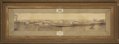
Photograph - Framed photograph of Warrnambool 1887, Town Panorama. Warrnambool Queen's Jubilee 1887, 1887
... This is a framed photograph of a panoramic section... This is a framed photograph of a panoramic section of the Warrnambool ...This is a framed photograph of a panoramic section of the Warrnambool township taken in 1887 to commemorate the Jubilee of the reign of Queen Victoria (1837-1887). The photograph is taken from Booval Hill (Liebig Street north) and shows the fencing in that area with groups of people in the foreground posing for the photograph. The panorama covers Liebig Street and Raglan Parade and includes private houses, a windmill and three tanks, St. John's Church, St. Joseph's Church, Tattersalls Hotel and the Saleyards.This photograph provides us with historical information on a section of the Warrnambool township in 1887 and is a valuable resource for researchers.This is a black and white photograph in a brown wooden frame and enclosed in glass. The photograph has a gilt metal edging outlined with ornate kite-shaped pieces on the corners and depicts a section of a town from an elevated position. At the top of the photograph is a crest in a shield shape and at the bottom is another shield shape containing the title of the photograph. The left centre section of the photograph is splotched or water-stained.Warrnambool Queen's Jubilee 1887warrnambool 1887, queen victoria's jubilee -
 Eltham District Historical Society Inc
Photograph, Peter Pidgeon, Birch Cottage, Eltham-Yarra Glen Road, Christmas Hills, 27 September 2018, 2018
Originally built by John Hill, a shoemaker at Kangaroo Ground around 1878. In the late 1970s when our Society was the Shire of Eltham Historical Society, an offer was made to the Society regarding use of an old cottage at Christmas Hills. The cottage sat beside Watsons Creek just outside the then Shire of Eltham but following municipal restructuring it now lies within the Shire of Nillumbik. For various reasons the offer ultimately lapsed. At that time some research on the cottage was carried out for the Society by Keith Chappel as part of a larger research project that he was doing. Keith’s notes were taken from Lands Department records and showed that the property was the subject of a permissive occupancy of Crown land comprising the creek reserve. In 1903 a Miner’s Right of one acre in area was granted to Edwin Samuel Birch. In 1907 Birch applied to purchase this land but was unable to because it was part of the creek reserve. The documents show that the cottage existed at that time. Upon Birch’s death in 1932, his daughter, Honor Mary Birch was granted a permit to occupy the residence. Honor Mary Birch, known as Nora, was born 1900, the daughter of Edwin Samuel Birch and Honor (nee Young). In 1939 she married George Henry Williams (aka Henry). Honor died 8 July 1976. Her siblings were Margaret Martin (dec), Bert Birch and Brigidene Brinkkotter. In her will she gave and bequeathed “all the improvements on the land held by me at Christmas Hills under Permissive Occupancy from the Department of Land and Survey consisting of the house property thereon and all the contents of the said house to my nephew Brian Joseph Martin of Christmas Hills aforesaid farmer”. The will described the property as a four room, five square house, about 100 years old with enclosed verandah, including kitchen, combined lounge dining room, bedroom and store room; built of ‘bush slabs’ with a corrugated iron roof. A dairy had been erected in 1935. After her death, the property was acquired by the Melbourne Metropolitan Board of Works in 1978. The property is listed on the Victorian Heritage Database HO200-Hill, later Birch farm complex, 945 Eltham-Yarra Glen Road, Watsons Creek and described as: The house has a steep but simply gabled roof form clad with corrugated iron, vertical adzed hardwood slab front wall construction, split palings to the gable ends; rubble freestone chimney at one end (with added gsi flue), pole-framed Graeme Butler & Associates, 2006: 101 Shire of Nillurnbik Planning Scheme Amendment C13 Heritage Assessments verandah (rebuilt?); six-pane double-hung sash windows; T&G bead-edge boarded ledged & braced door; and paling clad rooms added at verandah ends. A slab-clad large fireplace is at the north corner of the house, with a gsi upper cladding added and an internal lining of rubble stone. The rear facade is different construction, being drop-slab, and sits beneath a rear skillion addition to the main gabled form: this may be more recent construction. The house appears to have been once set up for public display and may have been recreated in part for that purpose. Outbuildings are reached by a track along the east side of the house, including what may have been a creamery (typical standard inter-war design clad with corrugated iron and lined with 1938 Lysaght Queens Head Australia galvanised sheet iron) and a paling clad gabled out-house. Timber outbuildings of differing eras are to the north-west of the house, with pole framing and paling infill construction and Redcliffe brand corrugated iron. Post and rail (front) and split paling (rear) fence remnants line the front boundary. Pepper trees part of house yard landscape49 born digital images (includes one panoramic stitch and nine frames from drone video)birch cottage, christmas hills, early settlers, edwin samuel birch, honor mary birch, john hill, watsons creek -
 Marysville & District Historical Society
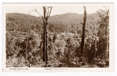
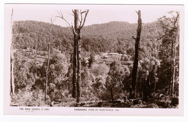
Postcard (item) - Black and white postcard, Rose Stereograph Company, Panoramic View of Marysville, Vic, 1913-1967
... A black and white photograph of a panoramic view... photograph of a panoramic view of Marysville, Victoria. The Rose ...A postcard in a series produced by the Rose Stereograph Company in Victoria, Australia as a souvenir of Marysville.An early photograph of a panoramic view of Marysville, Victoria.REAL PHOTO POST CARD THE "ROSE" SERIES DE LUXE PRODUCED IN AUSTRALIA PUBLISHED BY "THE ROSE STEREOGRAPHS" Armadale,/ Victoria.marysville, victoria, postcard, p. 2301, souvenir, rose series postcard -
 Marysville & District Historical Society
Postcard (item) - Black and white postcard, Rose Stereograph Company, Panoramic View of Marysville, Vic, 1913-1967
... A black and white photograph of a panoramic view.... A black and white photograph of a panoramic view of Marysville ...A postcard in a series produced by the Rose Stereograph Company in Victoria, Australia as a souvenir of Marysville.Panoramic view of Marysville, Victoria.REAL PHOTO POST CARD THE "ROSE" SERIES DE LUXE PRODUCED IN AUSTRALIA PUBLISHED BY "THE ROSE STEREOGRAPHS" Armadale,/ Victoria.marysville, victoria, postcard, p. 2301, souvenir, rose series postcard -
 Marysville & District Historical Society
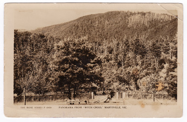
Postcard (item) - Black and white postcard, Rose Stereograph Company, Panorama From "Wych Cross," Marysville, Vic, 1913-1967
... A black and white photograph showing a panoramic view from..., Australia as a souvenir of Marysville. A black and white photograph ...A postcard in a series produced by the Rose Stereograph Company in Victoria, Australia as a souvenir of Marysville.A black and white photograph showing a panoramic view from Wych Cross which was a guesthouse in Marysville. The Wych Cross Private Guesthouse was part of the Wych Cross Private Hotel Co. Ltd of which Mr. Felix Jellicoe was Managing Director at the time. The guesthouse burnt down in a fire on the 14th of November, 1926. This fire started in the kitchen where it was soon extinguished by one of the employees. However, it is believed that sparks from the earlier fire, which were not noticed at the time, ignited the second fire which destroyed the weatherboard guesthouse in 20 minutes. Guests who were staying at the guesthouse were all away from the premises at the time of the fire and lost all their belongings; including one guest who lost a considerable sum of money.POST CARD REAL PHOTO/ THE "ROSE" SERIES DE LUXE PRODUCED IN AUSTRALIA Published by "The Rose Stereographs"/ Armadale, Victoria. "Sunnyside"/ Marysville/ 18/12/26 Dear Mr & Mrs De La Rue/ Just a line/ or two in which to convey the very/ best of good wishes. A very happy/ Christmas and Happy New Year/ to you and your family./ Yours sincerely Mrs. & Miss Newman. wych cross, marysville, victoria, p. 4959, rose series postcard, postcard, souvenir, wych cross hotel co ltd, felix jellicoe, guest house, 14th november 1926 -
 Bendigo Military Museum
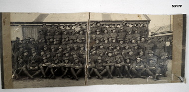
Photograph - PORTRAIT OF A GROUP OF SOLDIERS, c1935-1940
This was a panoramic wide portrait stuck on thick cardboard. There are seven rows of soldiers. They are wearing slouch hats. Their uniforms appear to be pre WW2 Militia. Part of a car can be seen on right side. There are also chimney stacks of water towers (?) there. In the background are old army huts.militia, photography - group portrait, australia -
 Bendigo Military Museum
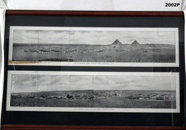
Photograph - PHOTOGRAPH WW1, FRAMED, c.1914-15
The two images were part of a book called, The All Australian Memorial as part of a fold out section. the two pages were lose in the book.Large timber frame, mid brown colour, dark green mount with glass. 2 black &white panoramic photos of the 1st Australian Division, Egypt. Camp scenes with tents, pyramids & sand.Below photos in black ink: "The 1st Australian Division, Australian Imperial Force - Egypt, 1914-15" Handwritten in black felt tip pen: "Property Bendigo RSL Museum, Peter Ball"photography-photographs, military history - army, eygpt pyramids, 1st australian division -
 Bendigo Military Museum
Photograph - PHOTOGRAPH GALLIPOLI, FRAMED, H J Lowe and G Downes, c.1915 - 1920
The photo relates to James Joseph Kirkham No 685. The story was that he brought the original negative home with him. Refer 1281 for his service history also 1986P.Heavy wooden frame, glass front, with dark grey border framing panoramic photo of a beach. North Beach, Anzac Cove by H J Lowe and G Downes.photography-photographs, frame accessories, military history - army, kirkham -
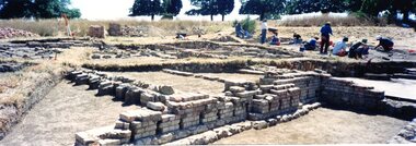 Greensborough Historical Society
Photograph - Photograph Collection, Jan Macdonald, Viewbank Homestead archaeological excavation 1999, 1999
In 1999, an archaeological dig was undertaken at the Viewbank Homestead site in Viewbank. This set of photographs was taken at the dig site in 1999. The house was built c1840 by James Williamson; it was later purchased by George Gear as a wedding gift to his daughter on her marriage to Dr Robert Martin. It became a grand mansion in the late 1800s but by the 1920s, it was stripped bare of materials and demolished in the 1920s. The archaeological dig was and insight into early life in the Viewbank HomesteadSet of 8 panoramic photos of archaeological dig and flyer for dig.viewbank homestead, banyule road viewbank, viewbank, archaeological digs