Showing 832 items
matching parish map
-
 Bendigo Historical Society Inc.
Map - JACK FLYNN COLLECTION: GIRGARRE, 14/10/1943
... Map: Parish of Girgarre , County of Rodney. Parish plan..., of Lands and Survey, Melbourne, Victoria Map: Parish of Girgarre ...Map: Parish of Girgarre , County of Rodney. Parish plan. Same map as 10100.20 but in poorer condition.By Authority, H.E.Daw, Government printer Melbourne. Drawn and Reproduced at the Dept, of Lands and Survey, Melbourne, Victoriamap, rodney, girgarre, girgarre, county of rodney -
 Bendigo Historical Society Inc.
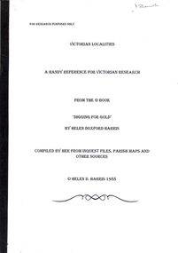
Book - STRAUCH COLLECTION - VICTORIAN LOCALITIES, A HANDY REFERENCE FOR VICTORIAN RESEARCH, FROM THE BOOK 'DIGGING FOR GOLD' BY HELEN DOXFORD HARRIS, 1988
... , compiled by her from inquest files, parish maps and other sources.... files, parish maps and other sources. Book STRAUCH COLLECTION ...Victorian Localities, a handy reference for Victorian research, from the book 'Digging for Gold' by Helen Doxford Harris, compiled by her from inquest files, parish maps and other sources.Helen D Harrisvictoria, history, localities -
 Bacchus Marsh & District Historical Society
Map, Bullengarook Parish, County of Bourke
... An undated parish plan map for the parish of Bullegarook...A single page paper map showing the parish plan map...An undated parish plan map for the parish of Bullegarook ...An undated parish plan map for the parish of Bullegarook. This parish area is close to the Bacchus Marsh district and borders some of the areas contained within the former Bacchus Marsh Shire and present day Moorabool Shire.A single page paper map showing the parish plan map for Bullengarook. This parish area contains the locality of Bullengarook and parts of the Wombat State Forest and is close to the town of Gisborne. A cadastral map showing land ownership. The map is not dated but a very similar map held by the State Library of Victoria is estimated to date from about 1927. The map is pasted into a bound volume containing 76 maps or plans in total. High resolution digital image stored on BMDHS computer network. bullengarook parish maps -
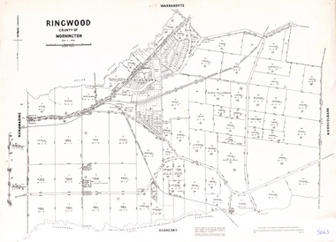 Ringwood and District Historical Society
Map - Parish of Ringwood, County of Mornington, Victoria, Original Land Owners
... Laminated Parish map of Ringwood detailing original Land... Road Ringwood North melbourne Laminated Parish map of Ringwood ...Laminated Parish map of Ringwood detailing original Land Owners' names, property locations and acreages. Details reproduced in 1957 by the Department of Lands and Survey, Melbourne, from original surveys of varying dates. -
 Clunes Museum
Map - CLUNES MAP SHOWING STREETS AND LOT NUMBERS
... MAPS, PARISH OF CLUNES, CLUNES TOWNSHIP... TOWNSHIP AND STREETS MAPS, PARISH OF CLUNES, CLUNES TOWNSHIP Map ...PURCHASED FROM DONORMAPS, PARISH OF CLUNES, CLUNES TOWNSHIPCLUNES TOWNSHIP AND STREETSlocal history, document, maps, clunes township -
 Bendigo Historical Society Inc.
Document - MCCOLL, RANKIN AND STANISTREET COLLECTION: REIMER BROS. KINGOWER
... Brothers claim at Kingower, also contains a large scale parish map... Brothers claim at Kingower, also contains a large scale parish map ...Manilla folder containing correspondence relating to Reimer Brothers claim at Kingower, also contains a large scale parish map of Kingower showing the position of the claim and leases 6278 held by Andrew Thomas Berriman and 6279 held by Florence Adelaide BerrimanMcColl Rankin & Stanistreetgold mining, miners' safety cage, kingower/union reef mines, gold mining, kingower, reimer brothers berriman -
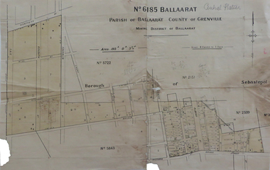 Federation University Historical Collection
Map, No 6185 Ballaarat Parish of Ballaarat County of Grenville, not dated
... No 6185 Ballaarat Parish of Ballaarat County of Grenville Map Map ...Printed map with pencil inscriptionsmap, parish of ballaarat, grenville county, sebastopol, central company engine house, wesleyan reserve, victoria street, yarrowee street, charlotte st, kyle street -
Bendigo Historical Society Inc.
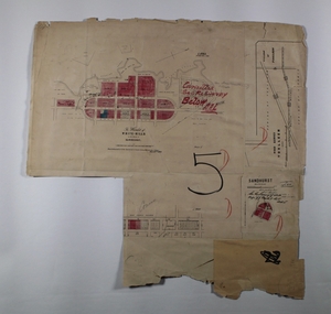
Map - TARNAGULLA SHEET 3, No date Visible
... parish plan Tarnagulla Map: Tarnagulla Sheet 3, hand written ...Map: Tarnagulla Sheet 3, hand written on the side of the map. ( number 152 in Map Cupboard 1)map, parish plan, tarnagulla -
Bendigo Historical Society Inc.
Map - TARNAGULLA SHEET 2, No date Visible
... Map: Tarnagulla Sheet 2, Parish plan... parish plan Tarnagulla Map: Tarnagulla Sheet 2, Parish plan Map ...Map: Tarnagulla Sheet 2, Parish planmap, parish plan, tarnagulla -
Bendigo Historical Society Inc.
Map - TARNAGULLA (PARTS), Circa 1880's
... parish plan Tarnagulla Map: Compilation of 3 hand draughted ...Map: Compilation of 3 hand draughted parish plans showing portions of Tarnagulla (number 261 in map cupboard 1)map, parish plan, tarnagulla -
Bendigo Historical Society Inc.
Map - TARNAGULLA SHEET 3, No date visible
... Map: Tarnagulla Sheet 3. Parish plan (number 308 in map... parish plan Tarnagulla Map: Tarnagulla Sheet 3. Parish plan ...Map: Tarnagulla Sheet 3. Parish plan (number 308 in map cupboard 1)map, parish plan, tarnagulla -
Bendigo Historical Society Inc.
Map - TARNAGULLA SHEET 2, No date visible
... Map: Tarnagulla Sheet 2. Parish plan (number 307 in map... parish plan Tarnagulla Map: Tarnagulla Sheet 2. Parish plan ...Map: Tarnagulla Sheet 2. Parish plan (number 307 in map cupboard 1)map, parish plan, tarnagulla -
Bendigo Historical Society Inc.
Map - TARNAGULLA SHEET 4, 25/11/1926
... Map: Tarnagulla Sheet 4. Parish plan (number 306 in map... parish plan Tarnagulla Map: Tarnagulla Sheet 4. Parish plan ...Map: Tarnagulla Sheet 4. Parish plan (number 306 in map cupboard 1)map, parish plan, tarnagulla -
Bendigo Historical Society Inc.
Map - WESTON RESURVEY, June 20th 1875
... Map: Weston, Resurvey.Hand draughted Parish plan (number... parish plan Weston Map: Weston, Resurvey.Hand draughted Parish ...Map: Weston, Resurvey.Hand draughted Parish plan (number 292 in map cupboard 1)map, parish plan, weston -
 Bendigo Historical Society Inc.
Map - LOCAL AREA PLANS, See above
... MAP parish plan Redcastle Yarraberb White Hills Toolleen ...Map: Compilation of maps: Village of Redcastle dated april 14 1861, Township of Yarraberb dated 14 July 1874, Hamlet of White Hills dated December 27 1872, Road survey of Toolleenmap, parish plan, redcastle, yarraberb, white hills, toolleen -
 Bendigo Historical Society Inc.
Map - REDCASTLE AND DARGILE, No date visible
... Map: Redcastle and Dargile. Parish plan...MAP parish plan Redcastle Dargile Pencil markings 27/6/78 ...Map: Redcastle and Dargile. Parish planPencil markings 27/6/78, 18/10/78map, parish plan, redcastle, dargile -
 Bendigo Historical Society Inc.
Map - JACK FLYNN COLLECTION: TARNAGULLA, 13/05/1922
... Map: Parish of Tarnagulla . This Item is in very poor... of Lands and Survey, Melbourne by W. J. Butson Map: Parish ...Map: Parish of Tarnagulla . This Item is in very poor condition.By Authority, A. J. Mullen, Government Printer, Melbourne. Lithographed at the Department of Lands and Survey, Melbourne by W. J. Butsonmap, gladstone, parish plan, tarnagulla -
 Bendigo Historical Society Inc.
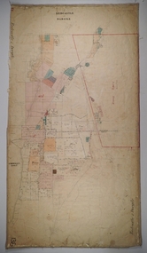
Map - JACK FLYNN COLLECTION: SALISBURY, 1965
... Map: Parish of Salisbury, County of Bendigo. Parish plan.... of Lands and Survey, Melbourne. Map: Parish of Salisbury, County ...Map: Parish of Salisbury, County of Bendigo. Parish plan.By Authority A. C. Brooks Government Printer, Melbourne. Drawn and Reproduced at the Department of Lands and Survey, Melbourne.map, bendigo, parish plan, salisbury -
 Bendigo Historical Society Inc.
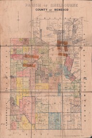
Map - JACK FLYNN COLLECTION: SHELBOURNE, 11/02/1937
... Map: Parish of Shelbourne, County of Bendigo. Parish plan.... and Survey, Melbourne, Victoria. Map: Parish of Shelbourne, County ...Map: Parish of Shelbourne, County of Bendigo. Parish plan.By Authority, H. J.Green, Government Printer. Drawn and Reproduced at the Dept, of Lands and Survey, Melbourne, Victoria.map, bendigo, parish plan, shelbourne -
 Bendigo Historical Society Inc.
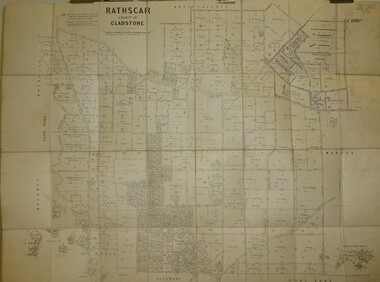
Map - JACK FLYNN COLLECTION: RATHSCAR, 14/09/1935
... Map: Parish of Rathscar, County of Gladstone. Parish plan.... Gladstone parish plan Rathscar Map: Parish of Rathscar, County ...Map: Parish of Rathscar, County of Gladstone. Parish plan.map, gladstone, parish plan, rathscar -
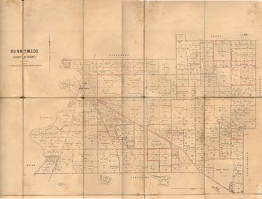 Bendigo Historical Society Inc.
Map - JACK FLYNN COLLECTION: RUNNYMEDE, June 1946
... Map: Parish of Runnymede, County of Rodney. Parish plan.... and Servey, Melbourne, Victoria. June, 1946. Map: Parish of Runnymede ...Map: Parish of Runnymede, County of Rodney. Parish plan.By Authority: J.J. Goourley, Government Printer, Melbourne. Drawn and Reproduced at the Lands and Servey, Melbourne, Victoria. June, 1946.map, rodney, parish plan, runnymede -
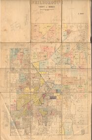 Bendigo Historical Society Inc.
Map - JACK FLYNN COLLECTION: NEILBOROUGH, 13/10/1927
... Map: Parish of Neilborough, County of Bendigo. Parish plan.... at the Department of Lands and Survey, Melbourne by W.J. Butson Map: Parish ...Map: Parish of Neilborough, County of Bendigo. Parish plan.Photo Lithographed at the Department of Lands and Survey, Melbourne by W.J. Butsonmap, bendigo, parish plan, neilborough -
 Bendigo Historical Society Inc.
Map - JACK FLYNN COLLECTION: MUSKERRY, 1962
... Map: Parish of Muskerry, County of Rodney. Parish plan.... of Lands and Survey, Melbourne Map: Parish of Muskerry, County ...Map: Parish of Muskerry, County of Rodney. Parish plan.By Authority: A.C. Brooks, Government Printer, Melbourne. Drawn and reproduced at the Department of Lands and Survey, Melbournemap, rodney, parish plan, muskerry -
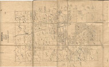 Bendigo Historical Society Inc.
Map - JACK FLYNN COLLECTION: MOORA, 9/10/22
... Map: Parish of Moora, County of Rodney. Parish plan.... and Survey, Melbourne by W.J. Butson. 3.10.22 Map: Parish of Moora ...Map: Parish of Moora, County of Rodney. Parish plan.By Authority A.J. Mullet Government Printer Melbourne. Photo Lithographed at the Dept, of Lands and Survey, Melbourne by W.J. Butson. 3.10.22map, rodney, parish plan, moora -
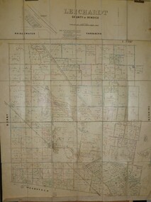 Bendigo Historical Society Inc.
Map - JACK FLYNN COLLECTION: LEICHARDT, 14/03/1`939
... Map: Parish of Leichardt, County of Bendigo. Parish plan...., of Lands and Survey, Melbourne, Victoria. 14.3.1939 Map: Parish ...Map: Parish of Leichardt, County of Bendigo. Parish plan.Drawn and Reproduced at the Dept, of Lands and Survey, Melbourne, Victoria. 14.3.1939map, bendigo, parish plan, leichardt -
 Bendigo Historical Society Inc.
Map - JACK FLYNN COLLECTION: HAYANMI, March 1953
... Map: Parish of Hayanmi, County of Bendigo. Parish plan...., Melbourne, Victoria Map: Parish of Hayanmi, County of Bendigo ...Map: Parish of Hayanmi, County of Bendigo. Parish plan.By Authority: W.M. Houston, Government Printer. Drawn and reproduced at the Dept, of Lands and Survey, Melbourne, Victoriamap, bendigo, parish plan, hayanmi -
 Bendigo Historical Society Inc.
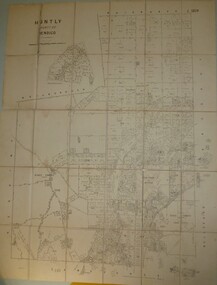
Map - JACK FLYNN COLLECTION: HUNTLY, 8/09/1921
... Map: Parish of Huntly, County of Bendigo. Parish plan.... Melbourne By W. J. Butson Map: Parish of Huntly, County of Bendigo ...Map: Parish of Huntly, County of Bendigo. Parish plan.By Authority, Govt., Printer. A. J. Mullett. Photo Lithographed at the Department of Land and Survey Melbourne By W. J. Butsonmap, bendigo, parish plan, huntly -
 Bendigo Historical Society Inc.
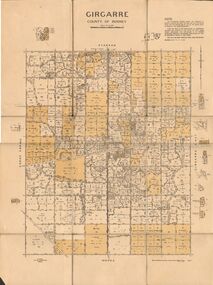
Map - JACK FLYNN COLLECTION: GIRGARRE, 14/10/1943
... Map: Parish of Girgarre. County of Rodney. Parish plan....: Parish of Girgarre. County of Rodney. Parish plan. Map JACK FLYNN ...Map: Parish of Girgarre. County of Rodney. Parish plan.By Authority, H.E. Daw, Government Printer Melbourne. Drawn and produced at the Dept of Lands and Survey, Melbourne, Victoria. 14.10.1943map, rodney, parish plan, girgarre, county of rodney -
 Bendigo Historical Society Inc.
Map - JACK FLYNN COLLECTION: BURNEWANG, 17/09/1918
... Map: Parish of Burnewang, County of Rodney. Parish plan....: Parish of Burnewang, County of Rodney. Parish plan. Map JACK ...Map: Parish of Burnewang, County of Rodney. Parish plan.By Authority, H. J. Green, Acting Government Printer Melbourne. Photo Lithographed at the Department of Lands and Survey, Melbourne by W. J. Butson.map, rodney, parish plan, burnewang, rodney