Showing 452 items matching "parks - greensborough"
-
 Eltham District Historical Society Inc
Slide - Photograph, Jacky Talbot, River of Life: Eltham Peace Banner, Sep 1986
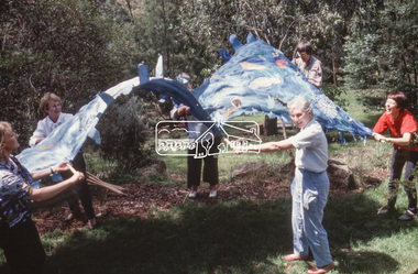
A River of Life: Eltham Peace Banner 1986 The Hiroshima Day Banner was conceived by Shire of Eltham Artist in Residence, Jacky Talbot and a number of other Eltham women as part of the “As We Are” community banner project. The women wanted to do something for Hiroshima Day and suggested that a workshop be set aside to make a banner. The group promoted it at the new Community Notice Board (Arthur Street and Main Road) on Hiroshima Day (August 6) and were photographed by the local newspaper publicising the group and drawing wider community attention to the remembrance of the day. Jacky Talbot, led the team who produced the banner, approximately 4.5 metres by 1.5 metres, of sewn and painted Australian flora and fauna. Workshops were held at the Eltham Community Arts Centre at Meruka House. Peace Banner Group members included Laurel Eckersall, Anne Laurence, Betty Johnson, Margaret Johnson and Joan Maclagan. One of the creators, Joan Maclagan, further gave expression in verse – Banner for Peace The 'River of Life' with about 30 other banners went on display in the “As We Are” exhibition held at the Eltham Community Centre on 9 October 1986, previewed by the Member for Greensborough, Ms Pauline Toner, and Eltham Shire President, Mr Bob Manuell. The full display continued in Woolworths (now Coles) Arcade. The banner was also carried by the group in the 1986 Eltham Festival Grand Parade on November 8, along with other group banner projects including that of the Eltham District Historical Society, after which they were displayed in the Shire of Eltham’s tent in Alistair Knox Park.betty johnson, eltham peace banner, hiroshima day banner, laurel eckersall, "as we are" community banner project, banner project, river of life banner, margaret johnson, meruka house, community arts centre, jacky talbot, eltham shire council artist in residence -
 Eltham District Historical Society Inc
Slide, Maroondah Aqueduct, Research, Victoria, 22 Mar. 1981
An inspection tour of the Maroondah Aqueduct was undertaken by the Shire of Eltham Historical Society on Sunday, March 22nd, 1981, commening where the aqueduct crosses Main Rd., Research, just below Eltham College. The Maroondah Aqueduct was part of Melbourne’s water supply system. It carried water over the 66 km from the Maroondah Reservoir on the Watts River at Healesville to the Preston Reservoir. Of this length, 41 km were open channel, 10 km, tunnel through hills and 15 km in 14 inverted siphons across stream valleys. The route of the aqueduct is north of Tarrawarra and Yarra Glen, along the Yarra escarpment south of Christmas Hills and crossing Watsons Creek into the present Shire of Eltham near Henley Rd. The eastern part of the route lies entirely within the former boundaries of the shire. The aqueduct passes south of Kangaroo Ground to Research and crosses the Diamond Creek by siphon at Allendale Rd., Eltham North. It then extends to Reservoir via St. Helena, Greensborough North and Bundoora. Water first flowed through the aqueduct in February 1891 when it was fed by a diversion weir on the Watts River. Records of the building of the aqueduct indicate that it was a significant construction achievement. The present Maroondah Reservoir was completed in 1927 and the aqueduct was enlarged at that time to take increased flows. About 1971 the section of the aqueduct through and north of Research was replaced by a large pipe and that section of the channel is now unused. The channel has remained largely intact (unlike sections at Greensborough and Bundoora where long lengths of the disused aqueduct have been demolished or filled in). The M.M.B.W. relinquished control of the disused aqueduct reserve which is crown land and the Shire of Eltham took control of this section of the reserve as a linear park. The Maroondah Aqueduct is considered to be an important historic structure, not just to the local area but to the metropolitan area generally. It is considered important to preserve substantially intact long lengths of the disused aqueduct, together with its bridges and other associated structures. 35 mm colour positive transparency (1 of 5) Mount - Agfachrome Agfa CS System black 8 dotsactivities, heritage excursion, maroondah aqueduct, research (vic.), shire of eltham historical society -
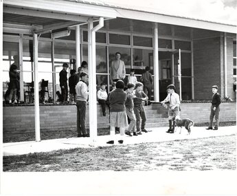
![Newspaper Clipping - Digital Image, Switch of track site riles dads 1973 [Willinda Park], 21/08/1973](/media/collectors/4f729f5697f83e03086015b8/items/5eb3d80521ea670b94305a93/item-media/5eb3d84821ea670b94308ecf/item-fit-380x285.jpg) Greensborough Historical Society
Greensborough Historical SocietyNewspaper Clipping - Digital Image, Switch of track site riles dads 1973 [Willinda Park], 21/08/1973
In 1973, parents of children in Diamond Valley Little Athletics were angered at the suggestion that the proposed all weather track at Willinda Park be scrapped. There was some talk of acquiring "Partington land" between the rail line and Plenty River, south of Church Street. News clipping, black and white text. 3 scans.diamond valley little athletics association, willinda park, partington family -
 Greensborough Historical Society
Article - Article, Journal, Melbourne Harbor Trust, "The Word is Progress": by Robin Hay, 1960_03
The opening of Reid's Lightweight Aggregate Pty Ltd ( a subsidiary of Reid's Quarries Ltd) in Greensborough, circa 1960. Explains the method of manufacture and uses of shalite in building industry. Reid's later became Albion Reid before being taken over by Boral. The shalite quarry, now closed, was on the site now called Blue Lake in Yellow Gum Park, Plenty.7 photocopied pages, text and colour and black nd white illustrations.reids quarries, shalite, aggregate, yellow gum park, plenty -
 Greensborough Historical Society
Book, Isabel Ellender, The Plenty Valley Corridor: the archaeological survey of Aboriginal sites / by Isabel Ellender 1991, 1991_
This archaeological survey of the Plenty Valley was conducted by Isabel Ellender in 1991 for the Board of Works (Melbourne Water), in particular the Plenty Gorge Metropolitan Park. The area studied is north of Greensborough to Whittlesea. A number of Aboriginal sites were identified and recommendations made for the future.67 p., illus., maps. Plastic spiral binding.plenty river, aboriginal heritage sites, plenty gorge metropolitan park -
 Greensborough Historical Society
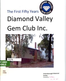
Booklet, Diamond Valley Gem Club, Diamond Valley Gem Club Inc.: the first fifty years
History of the Diamond Valley Gem Club 1968 - 201832 p., text and col. illustrationsdiamond valley gem club, lapidary, gem clubs, grace park -
 Greensborough Historical Society
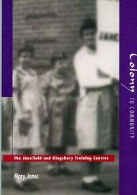
Book, Mary LucilleJones, Colony to community: the Janefield and Kingsbury Training Centres, 1997
126 p. black and white illustrationsnon-fictionjanefield training centre, kingsbury training centre, intellectually disabled, janefield, mont park -
 Greensborough Historical Society
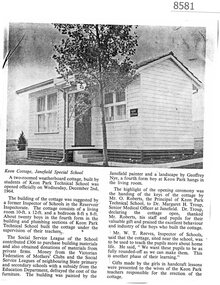
Article - Newspaper Clipping (copy), Keon Cottage, Janefield Special School 1964, 1964
News report about the cottage built at Janefield Special School by students from Keon Park Technical School in 1964. The cottage was used to teach Janefield students 'more about home life'.Copy of newspaper clipping, black text and image.janefield, janefield special school, keon park technical school, keon cottage janefield -
 Greensborough Historical Society
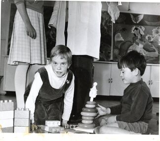
Photograph, Mental Health Department, Children at play, Janefield 1968, 1968
Photograph of two children playing on floor at Janefield 1968Black and white photographStamped on back: "Mental Health Dept., Negative Ref: M25K, Mont Park 1968"janefield, janefield special school -
 Greensborough Historical Society
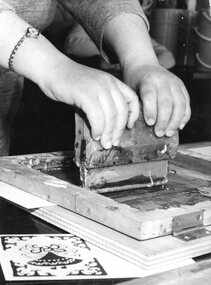
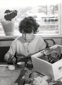
Photograph, Mental Health Department, Printmaking demonstration, Janefield 1968, 1968
Close up photograph of a printmaking demonstration at Janefield 1968Black and white photographStamped on back: "Mental Health Dept., Negative Ref: M25A, Mont Park 1968"janefield, janefield special school, printmaking -
 Greensborough Historical Society
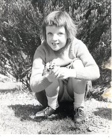
Photograph, Mental Health Department, Girl with daisies, Janefield 1968, 1968
Photograph of a Janefield student with a bunch of daisies 1968Black and white photographStamped on back: "Mental Health Dept., Negative Ref: M25G, Mont Park 1968"janefield, janefield special school -
 Greensborough Historical Society
Magazine, Banyule Banner December 2023, 2023_12
The Banyule Banner is published by Banyule Council to advertise upcoming events in the City of Banyule and to report on past events. This edition contains reports on Carols by Candlelight, a waste wise Christmas, Ivanhoe Park Croquet Club, council services and community events.A record of events within the City of Banyule.24 pages, colour illustrations. banyule banner, banyule council -
 Greensborough Historical Society
Photograph, Mental Health Department, Boys playing outside, Janefield 1968, 1968
Photograph of a group of Janefield students playing and observing others 1968Black and white photographStamped on back: "Mental Health Dept., Negative Ref: M16, Mont Park 1968"janefield, janefield special school -
 Greensborough Historical Society
Photograph, Mental Health Department, Girl making paper chains, Janefield 1968, 1968
Photograph of a Janefield student making paper chains 1968Black and white photographStamped on back: "Mental Health Dept., Negative Ref: M25B, Mont Park 1968"janefield, janefield special school -
 Greensborough Historical Society
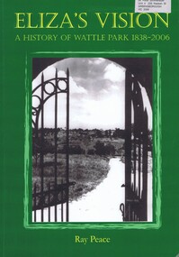
Book, Ray Pearce, Eliza's vision: a history of Wattle Park 1838-2006, 2006
An outline of the history of Wattle Park (Vic).207 p., illus., colour map.non-fictionAn outline of the history of Wattle Park (Vic).urban parks - melbourne, wattle park (vic.), parks - melbourne - history -
 Greensborough Historical Society
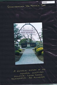
Photograph - Folder of photographs, Ada Allingham, Greensborough War Memorial Park: photos by Ada Allingham, 2003
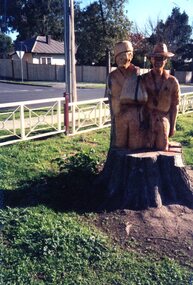
... Greensborough War Memorial Park: photos by Ada Allingham...greensborough war memorial park... of original chainsaw statues at Greensborough War Memorial Park... working on his artworks. greensborough war memorial park leigh ...Photographs by Ada Allingham taken during the carving of original chainsaw statues at Greensborough War Memorial Park. Statues carved by Leigh Conkie in 2003. Some newspaper reports are also included. Of particular interest are the photographs of chainsaw artist Leigh Conkie working on his artworks.Plastic folder with 20 pages of colour photographs mounted on black card with gold pen captions, includes newspaper clippings.greensborough war memorial park, leigh conkie, chainsaw sculptures, ada allingham -
 Greensborough Historical Society
Photograph - Photograph Collection, Greensborough War Memorial Park Sculptures, 2003c
... Greensborough War Memorial Park Sculptures...greensborough war memorial park... Greensborough War Memorial park. This collection is by an unknown... in Greensborough War Memorial Park.... of trees planted around Greensborough War Memorial park ...Sculptures created from stumps of trees planted around Greensborough War Memorial park. This collection is by an unknown photographer.Memorial to past armed services people from Greensborough District.Set of 8 photographs of chainsaw sculptures in Greensborough War Memorial Park.greensborough war memorial park, sculptures, ester street, leigh conkie, chainsaw sculptures, war memorials -
 Greensborough Historical Society
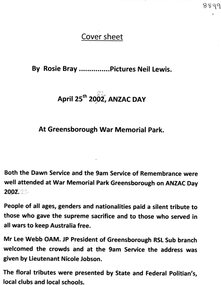
Article - Article and Booklet, Rosie Bray et al, Anzac Day Memorial Service, 25th April 2022, 25/04/2022
... greensborough war memorial park...Anzac Memorial Service at Greensborough War Memorial Park... at Greensborough War Memorial Park. Review by Rosie Bray, Anzac Day service ...Anzac Memorial Service at Greensborough War Memorial Park. Review by Rosie Bray, Anzac Day service booklet from Greensborough RSL and 5 photographs by Neil Lewis.1 cover sheet, 8 page booklet and 5 photosgreensborough rsl, greensborough war memorial park, rosie bray, neil lewis -
 Greensborough Historical Society
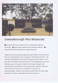
Article - Article and Photograph, Yarra Plenty Regional Library, The Fallen Soldiers' Memorial: Greensborough War Memorial Park, 20/01/2013
... The Fallen Soldiers' Memorial: Greensborough War Memorial...greensborough war memorial park..., Greensborough War Memorial Park. Article downloaded from Wikinorthia.... Fallen Soldiers Memorial, Greensborough War Memorial Park ...Article regarding World War 1 Fallen Soldiers Memorial, Greensborough War Memorial Park. Article downloaded from Wikinorthia.Article and photograph greensborough war memorial park, fallen soldiers memorial greensborough -
 Greensborough Historical Society
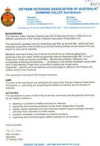
Article - Article and Photographs, Vietnam Veterans Association of Australia Diamond Valley Sub-Branch, 18/08/2023
... greensborough war memorial park...Greensborough Historical Society 34A Glenauburn Road Lower ...Article with Photographs regarding the Vietnam Veterans of Australia and the commemoration of the end of the Vietnam War. Photographs by Rosie Bray.Article with Photographs, 7 pagesvietnam veterans, diamond valley vietnam veterans, vietnam war, war memorial, greensborough war memorial park -
 Greensborough Historical Society
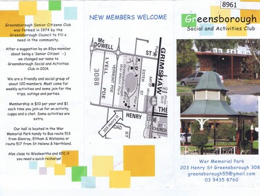
Pamphlet, Greensborough Social and Activities Club, Greensborough Social And Activities Club, War Memorial Park, 2014
... greensborough war memorial park... memorial park Pamphlet with photographs Greensborough Social ...Pamphlet about the Greensborough Social And Activities Club (formerly Greensborough Senior Citizens Club) held in the clubrooms at War Memorial Park.Pamphlet with photographssenior citizens, greensborough social and activities club, greensborough war memorial park -
 Greensborough Historical Society
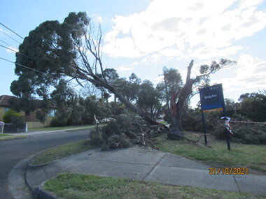
Photograph - Photograph - Digital Image, Peter Simmenauer, Storm damage, Barclay Park 2021, 27/10/2021
... wiring. barclay park mackenzie street greensborough plenty lane ...Storm damage incurred on night of 27-28/10/2021 at Barclay Park, cnr. Mackenzie Street & Plenty Lane, Greensborough. SES have lopped some of the dangerous tree limbs, but some are still resting on electric and communication wiring. Colour digital photographDate stamped: 31/10/2021barclay park, mackenzie street greensborough, plenty lane greensborough, storm damage -
 Greensborough Historical Society
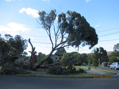
Photograph - Photograph - Digital Image, Peter Simmenauer, Storm damage, Barclay Park 2021, 27/10/2021
... wiring. barclay park mackenzie street greensborough plenty lane ...Storm damage incurred on night of 27-28/10/2021 at Barclay Park, cnr. Mackenzie Street & Plenty Lane, Greensborough. SES have lopped some of the dangerous tree limbs, but some are still resting on electric and communication wiring. Colour digital photographDate stamped: 31/10/2021barclay park, mackenzie street greensborough, plenty lane greensborough, storm damage -
 Greensborough Historical Society
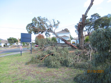
Photograph - Photograph - Digital Image, Peter Simmenauer, Storm damage, Barclay Park 2021, 27/10/2021
... wiring. barclay park mackenzie street greensborough plenty lane ...Storm damage incurred on night of 27-28/10/2021 at Barclay Park, cnr. Mackenzie Street & Plenty Lane, Greensborough. SES have lopped some of the dangerous tree limbs, but some are still resting on electric and communication wiring. Colour digital photographDate stamped: 31/10/2021barclay park, mackenzie street greensborough, plenty lane greensborough, storm damage -
 Greensborough Historical Society
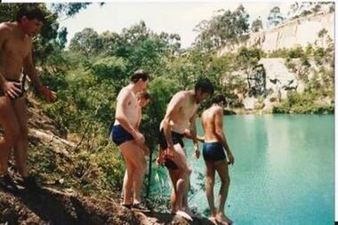
Photograph - Photograph - Digital Image, Swimming at Blue Lake
Undated photographs of young men swimming at Blue Lake. Blue Lake is located in Yellow Gum Park, a section of the Plenty Gorge Metropolitan Park.3 digital photographsblue lake, yellow gum park, plenty gorge park, plenty river -
 Greensborough Historical Society
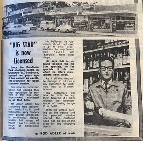
Photograph - Newspaper Clipping - Digital Image, Diamond Valley News, "Big Star" is now licensed, 14/09/1971
The 1971 owner of the "Big Star" supermarket in Bundoora Park (now Andrew Place) shopping centre, Ron Adler discusses his business and what it offers to customers.Digital copy of newspaper advertisementbig star supermarket bundoora, bundoora park shops, andrew place shops, grimshaw street bundoora, ron adler -
 Greensborough Historical Society
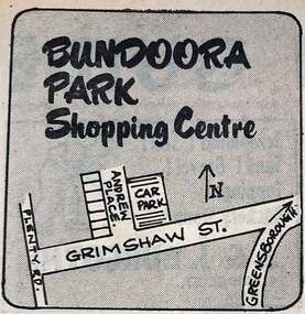
Photograph - Newspaper Clipping - Digital Image, Diamond Valley News, Bundoora Park shopping centre 1971, 1971
in 1971 this area was called Bundoora Park and the shops had same name. It has been renamed Andrew Place Shopping Centre as people confused it when Bundoora Park in Plenty Road opened. Digital copy of newspaper advertisementbundoora park shops, andrew place shops, grimshaw street bundoora