Showing 443 items
matching plotting
-
 Victorian Interpretive Projects Inc.
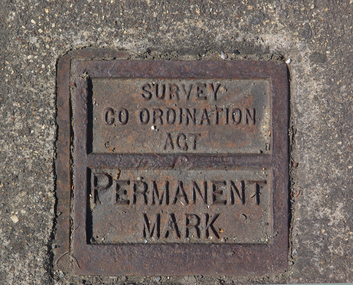
Photograph - Colour, Ballarat Survey Permanent Mark
A survey Permanent Mark was used by surveyors to enable them to plot land accurately.A colour photograph of a metal mark in the footpath on the corner of Ballarat's Sturt Street and Doveton Street. The Permanent Mark was put in place as part of the Survey Co ordination Act ballarat, survey, surveyor, footpath, infrastructure -
 Greensborough Historical Society
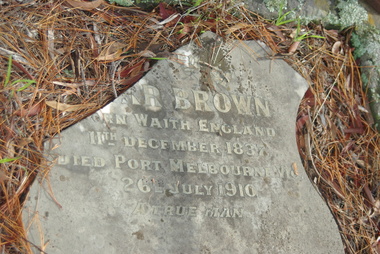
Photograph - Digital Image, Grave of Carr Brown, Greensborough Cemetery, 26/07/1910
Grave of Carr Brown (died 26/07/1910) in Plot# I17 Greensborough CemeteryGreensborough Cemetery was created when land was given for the cemetery by Mr William Poulter, a local settler, about 1864. The cemetery holds the graves of many early settlers in the district. Digital copy of colour photograph of grave/headstone [damaged]carr brown, greensborough cemetery -
 Greensborough Historical Society
Photograph - Digital Image, Grave of Carr Brown, Greensborough Cemetery, 26/07/1910
Grave of Carr Brown (died 26/07/1910) in Plot# I17 Greensborough Cemetery.Greensborough Cemetery was created when land was given for the cemetery by Mr William Poulter, a local settler, about 1864. The cemetery holds the graves of many early settlers in the district. Digital copy of colour photograph of grave/headstone.carr brown, greensborough cemetery -
 Greensborough Historical Society
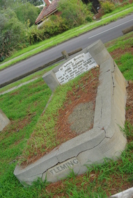
Photograph - Digital Image, Grave of John Fleming, Greensborough Cemetery, 08/06/1945
Grave of John Fleming (died 8/6/1945) in Plot# P9 Greensborough Cemetery. Greensborough Cemetery was created when land was given for the cemetery by Mr William Poulter, a local settler, about 1864. The cemetery holds the graves of many early settlers in the district. Digital copy of colour photograph of grave/headstone.john fleming, greensborough cemetery -
 Greensborough Historical Society
Photograph - Digital Image, Grave of William Poulter, Greensborough Cemetery, 22/02/1874
Grave of William Poulter (died 22/02/1874) in Plot#C13 Greensborough Cemetery.Greensborough Cemetery was created when land was given for the cemetery by Mr William Poulter, a local settler, about 1864. The cemetery holds the graves of many of the early settlers in the district. The cemetery holds approximately 250 grave sites with 350 people buried there. Digital copy of colour photograph of grave/headstone.william poulter, greensborough cemetery -
 Greensborough Historical Society
Photograph - Digital Image, Grave of Carr Brown, Greensborough Cemetery, 26/07/1910
Grave of Carr Brown (died 26/07/1910) in Plot# I17 Greensborough Cemetery. Greensborough Cemetery was created when land was given for the cemetery by Mr William Poulter, a local settler, about 1864. The cemetery holds the graves of many of the early settlers in the district. Digital copy of colour photograph of grave/headstone [damaged]greensborough cemetery, carr brown -
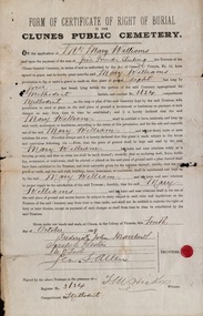 Federation University Historical Collection
Certificate, Form of Certificate of Right of Burial in the Clunes Public Cemetery: Mrs Mary Williams, 1899, 10/10/1899
Burial form for the Clunes Public Cemetery. Mrs Mary Williams completed the form to purchase a plot in the Methodist Section, Plot 3634. Paper outlines in detail the conditions and responsibilities of heirs with regard to the area. The Trustees of the Cemetery, Frederick John Matthews, Joseph Preston, M O'Toole and s. Allen signed this before a witness.Foolscap size with appropriate information written in by hand Signatures of Trustees Date: 10 October 1899 Red sealmary williams, clunes public cemetery, right of burial, methodist section, trustees, frederick john matthews, m o'toole, s allen, joseph preston -
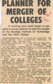 Bendigo Historical Society Inc.
Document - LA TROBE UNIVERSITY BENDIGO COLLECTION: PLANNER FOR MERGER OF COLLEGES
A Bendigo ' Advertiser ' article titled ' Planner for Merger of Colleges. ' A master planner is needed to plot the merger of the Bendigo Institute of Technology and the State College. Mr. R. says it is needed as soon as possible. It is hoped it will be called the Northern College of Advanced Education. 1-6-1974.bendigo, education, bit and btc merger, la trobe university bendigo collection, collection, bendigo, tertiary education, bendigo teachers' college, state college, bendigo institute of technology, mr. r. birrell, northern college of advanced education, merger, amalgamation -
 Whitehorse Historical Society Inc.
Map, City of Nunawading, 1973
Map showing streets, plot numbers, schools, open space and land usage.Map showing streets, plot numbers, schools, open space and land usage. A project by A Gray, student at Vermont High School. Area covered from Canterbury Road to Burwood Road and Terrara Road to Morack Road. Scale: 800 ft: 1 inchMap showing streets, plot numbers, schools, open space and land usage.vermont south, vermont, vermont high school, parks and reserves -
University of Melbourne, Burnley Campus Archives
Document, Victorian College of Agriculture and Horticulture, Pruning Garden, 1995
pruning garden, field station, orchard, vcah burnley, horticultural resources area, student gardens, ground cover plots, students working poutside, plan -
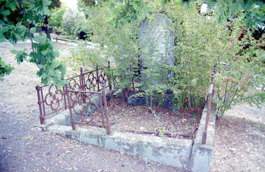
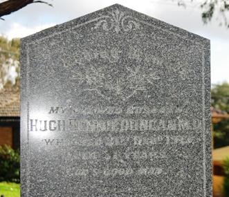 Greensborough Historical Society
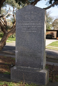
Photograph - Digital Image, Grave of Hugh Rennie Duncan, Greensborough Cemetery, 31/12/1913
Grave of Hugh Rennie Duncan (died 31/12/1913) in Plot# Q11 Greensborough CemeteryGreensborough Cemetery was created when land was given for the cemetery by Mr William Poulter, a local settler, about 1864. The cemetery holds the graves of many early settlers in the district. Digital copy of colour photograph of grave/headstone.hugh rennie duncan, greensborough cemetery -
 Greensborough Historical Society
Photograph - Digital Image, Grave of Thomas W Finn, Greensborough Cemetery, 17/06/1938
Grave of Thomas W. Finn (died 17/06/1938) in Plot#Q11 Greensborough Cemetery. Greensborough Cemetery was created when land was given for the cemetery by Mr William Poulter, a local settler, about 1864. The cemetery holds the graves of many early settlers in the district. Digital copy of colour photograph of grave/headstone [damaged headstone]thomas w finn, greensborough cemetery -
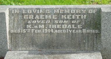 Greensborough Historical Society
Photograph - Digital Image, Grave of Graeme K Iredale, Greensborough Cemetery, 15/02/1944
Grave of Graeme K. Iredale (died 15/02/1944) in Plot# K7 Greensborough CemeteryGreensborough Cemetery was created when land was given for the cemetery by Mr William Poulter, a local settler, about 1864. The cemetery holds the graves of many early settlers in the district. Digital copy of colour photograph of grave/headstone.graeme k iredale, greensborough cemetery -
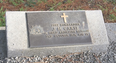 Greensborough Historical Society
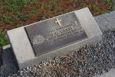
Photograph - Digital Image, Grave of John Huxley Carse, Greensborough Cemetery, 02/10/1926
Grave of John Huxley Carse (died 02/10/1926) in Plot#J15 Greensborough Cemetery. Greensborough Cemetery was created when land was given for the cemetery by Mr William Poulter, a local settler, about 1864. The cemetery holds the graves of many early settlers in the district. Digital copy of colour photograph of grave/headstone.john huxley carse, greensborough cemetery -
 Greensborough Historical Society
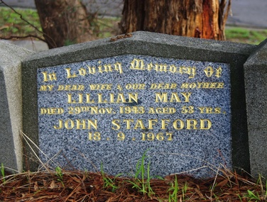
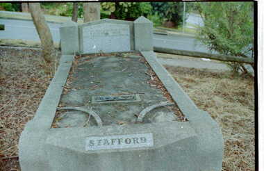
Photograph - Digital Image, Grave of Lillian M. Stafford, Greensborough Cemetery, 29/11/1943
Grave of Lillian M. Stafford (died 29/11/1943) in Plot#R3 Greensborough Cemetery. Greensborough Cemetery was created when land was given for the cemetery by Mr William Poulter, a local settler, about 1864. The cemetery holds the graves of many early settlers in the district. Digital copy of colour photograph of grave/headstone.lillian stafford, greensborough cemetery -
 Greensborough Historical Society
Photograph - Digital Image, Grave of William J Thompson, Greensborough Cemetery, 17/09/1935
Grave of William J. Thompson (died 17/09/1935) in Plot#E13 Greensborough Cemetery. Greensborough Cemetery was created when land was given for the cemetery by Mr William Poulter, a local settler, about 1864. The cemetery holds the graves of many early settlers in the district. Digital copy of colour photograph of grave/headstone.william j thompson, greensborough cemetery -
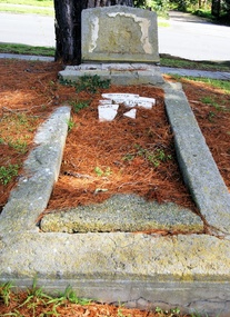
 Greensborough Historical Society
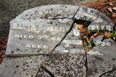
Photograph - Digital Image, Grave of David E. Wheeler, Greensborough Cemetery, 05/10/1926
Grave of David E. Wheeler (died 1926) in Plot# G14 Greensborough Cemetery. Headstone is damaged.Greensborough Cemetery was created when land was given for the cemetery by Mr William Poulter, a local settler, about 1864. The cemetery holds the graves of many early settlers in the district. Digital copy of colour photograph of grave/headstone [damaged]david e wheeler, greensborough cemetery -
 Greensborough Historical Society
Photograph - Digital Image, Grave of Graeme K Iredale, Greensborough Cemetery, 15/02/1944
Grave of Graeme K. Iredale (died 15/02/1944) in Plot# K7 Greensborough Cemetery.Greensborough Cemetery was created when land was given for the cemetery by Mr William Poulter, a local settler, about 1864. The cemetery holds the graves of many early settlers in the district. Digital copy of colour photograph of grave/headstone.graeme k iredale, greensborough cemetery -
 Greensborough Historical Society
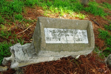
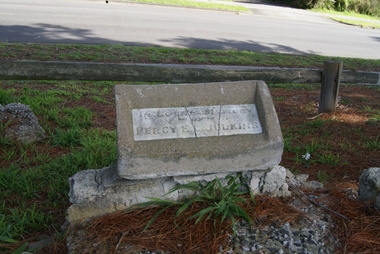
Photograph - Digital Image, Grave of Percy E Judkins, Greensborough Cemetery, 12/09/1938
Grave of Percy E Judkins (died 12/09/1938) in Plot# Q13 Greensborough Cemetery. Greensborough Cemetery was created when land was given for the cemetery by Mr William Poulter, a local settler, about 1864. The cemetery holds the graves of many early settlers in the district. Digital copy of colour photograph of grave/headstone.percy e judkins, greensborough cemetery -
 Greensborough Historical Society
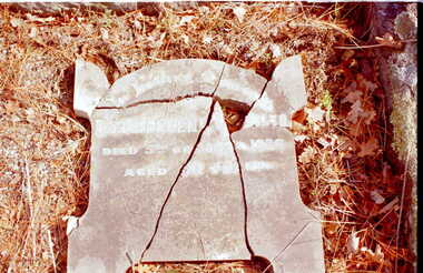
Photograph - Digital Image, Grave of Thomas W Finn, Greensborough Cemetery, 17/06/1938
Grave of Thomas W. Finn (died 1838) in Plot#Q11 Greensborough Cemetery. Damaged headstone.Greensborough Cemetery was created when land was given for the cemetery by Mr William Poulter, a local settler, about 1864. The cemetery holds the graves of many of the early settlers in the district. The cemetery holds approximately 250 grave sites with 350 people buried there. Digital copy of colour photograph of grave/headstone [damaged]thomas w finn -
 Greensborough Historical Society
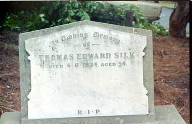
Photograph - Digital image, Grave of Thomas E Silk, Greensborough Cemetery, 07/08/1924
Grave of Thomas E. Silk (died 07/08/1924) in Plot#J7 Greensborough Cemetery.Greensborough Cemetery was created when land was given for the cemetery by Mr William Poulter, a local settler, about 1864. The cemetery holds the graves of many of the early settlers in the district. The cemetery holds approximately 250 grave sites with 350 people buried there. Digital copy of colour photograph of grave/headstone.thomas silk, greensborough cemetery -
 Greensborough Historical Society
Photograph - Digital Image, Grave of Lillian M. Stafford, Greensborough Cemetery, 29/11/1943
Grave of Lillian M. Stafford (died 29/11/1943) in Plot#R3 Greensborough Cemetery.Greensborough Cemetery was created when land was given for the cemetery by Mr William Poulter, a local settler, about 1864. The cemetery holds the graves of many of the early settlers in the district. The cemetery holds approximately 250 grave sites with 350 people buried there. Digital copy of colour photograph of grave/headstone.lillian stafford, greensborough cemetery -
 Greensborough Historical Society
Photograph - Digital Image, Grave of William J Thompson, Greensborough Cemetery, 17/09/1935
Grave of William J. Thompson (died 17/09/1935) in Plot#E13 Greensborough Cemetery.Greensborough Cemetery was created when land was given for the cemetery by Mr William Poulter, a local settler, about 1864. The cemetery holds the graves of many of the early settlers in the district. The cemetery holds approximately 250 grave sites with 350 people buried there. Digital copy of colour photograph of grave/headstone.william j thompson, greensborough cemetery -
 Greensborough Historical Society
Photograph - Digital Image, Grave of David Eugene Wheeler, Greensborough Cemetery, 05/10/1926
Grave of David Eugene Wheeler (died 05/10/1926) in Plot# G14 Greensborough Cemetery.Greensborough Cemetery was created when land was given for the cemetery by Mr William Poulter, a local settler, about 1864. The cemetery holds the graves of many of the early settlers in the district. The cemetery holds approximately 250 grave sites with 350 people buried there. David Eugene Wheeler died 5/10/1926Digital copy of colour photograph of grave/headstone [damaged]david e wheeler, greensborough cemetery -
 Greensborough Historical Society
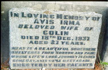
Photograph - Digital Image, Grave of Avis I. Williams, Greensborough Cemetery, 18/12/1937
Grave of Avis I. Williams (died 18/12/1937) in Plot# I7 Greensborough Cemetery.Greensborough Cemetery was created when land was given for the cemetery by Mr William Poulter, a local settler, about 1864. The cemetery holds the graves of many of the early settlers in the district. The cemetery holds approximately 250 grave sites with 350 people buried there. Avis Irma Williams died 18/12/1937)Digital copy of colour photograph of grave/headstone.avis williams, greensborough cemetery -
 Greensborough Historical Society
Photograph - Digital Image, Grave of John Huxley Carse, Greensborough Cemetery, 02/10/1926
Grave of John Huxley Carse (died 02/10/1926) in Plot#J15 Greensborough Cemetery. Greensborough Cemetery was created when land was given for the cemetery by Mr William Poulter, a local settler, about 1864. The cemetery holds the graves of many early settlers in the district. Digital copy of colour photograph of grave/headstone.john huxley carse, greensborough cemetery -
 Greensborough Historical Society
Photograph - Digital Image, Grave of Hugh Rennie Duncan, Greensborough Cemetery, 31/12/1913
Grave of Hugh Rennie Duncan (died 31/12/1913) in Plot# Q11 Greensborough CemeteryGreensborough Cemetery was created when land was given for the cemetery by Mr William Poulter, a local settler, about 1864. The cemetery holds the graves of many early settlers in the district. Digital copy of colour photograph of grave/headstone.hugh rennie duncan, greensborough cemetery -
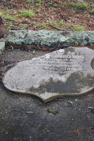
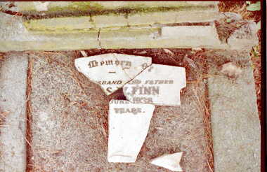
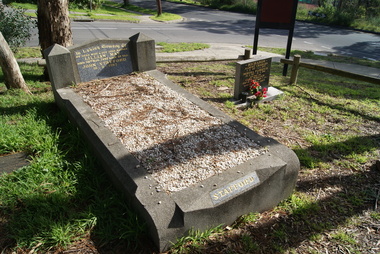
![Photograph - Digital Image, Grave of Thomas W Finn, Greensborough Cemetery [damaged headstone], 17/06/1938](/media/collectors/4f729f5697f83e03086015b8/items/54c5c9682162f11730528332/item-media/54c5c9a52162f117305289ac/item-fit-380x285.jpg) Greensborough Historical Society
Greensborough Historical SocietyPhotograph - Digital Image, Grave of Thomas W Finn, Greensborough Cemetery [damaged headstone], 17/06/1938
Grave of Thomas W. Finn (died 17/06/1938) in Plot#Q11 Greensborough Cemetery. Greensborough Cemetery was created when land was given for the cemetery by Mr William Poulter, a local settler, about 1864. The cemetery holds the graves of many early settlers in the district. Digital copy of colour photograph of grave/headstone [damaged]thomas w finn, greensborough cemetery -
 Greensborough Historical Society
Photograph - Digital Image, Grave of Percy E Judkins, Greensborough Cemetery, 12/09/1938
Grave of Percy E Judkins (died 12/09/1938) in Plot# Q13 Greensborough Cemetery. Greensborough Cemetery was created when land was given for the cemetery by Mr William Poulter, a local settler, about 1864. The cemetery holds the graves of many early settlers in the district. Digital copy of colour photograph of grave/headstone.percy e judkins, greensborough cemetery -
 Greensborough Historical Society
Photograph - Digital Image, Grave of Lillian M. Stafford, Greensborough Cemetery, 29/11/1943
Grave of Lillian M. Stafford (died 29/11/1943) in Plot#R3 Greensborough Cemetery. Greensborough Cemetery was created when land was given for the cemetery by Mr William Poulter, a local settler, about 1864. The cemetery holds the graves of many early settlers in the district. Digital copy of colour photograph of grave/headstone.lillian stafford, greensborough cemetery