Showing 3056 items matching "public buildings"
-
 Bendigo Historical Society Inc.
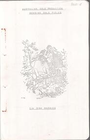
Document - MINING IN BENDIGO COLLECTION: BENDIGO GOLD FIELDS, 1968
... , location, public buildings and organisations and mines listed... and depth, location, public buildings and organisations and mines ...Typed copy of the Bendigo Gold Fields , collected and arranged by V. R. Dwyer, 1968. On front cover: Australian Gold Production Bendigo Gold Field. Image of tin dish washing. Cover has an image of two people tin dish washing. Notes include a brief history of gold in Australia, Bendigo Goldfield yields, Bendigo Gold Nuggets, Victorian Nuggets, gold prices, yield for the years 1851 to 1890, lines of reef, mine shafts and depth, location, public buildings and organisations and mines listed for each reef. Typed copy of this document is held in Folder 130, number 3621.18.cottage, miners, mining in bendigo, bendigo gold fields index, v r dwyer, strzelecki, edward hargreaves, thomas hancock, henry frenchman, wittscheibe, ballerstedt, fortuna villa, george lansell, the rocks, victoria nugget, dascombe nugget, welcome stranger, welcome nugget, canadian nugget, sarah sands, lady hotham, maryborough, heron nugget, blanche barkley, vicount canterbury, precious nugget, poseidon, gold prices, gold yield 1851 - 1890, location of shafts, mechanics institute, old masonic hall, court, st killians, forrest st methodist church, hospital, baptist church, bendigo gas company, st andrews presbyterian church, bendigo benevolent home, railway, st marys church of england, bendigo m p building society, st pausl church of england, high school, city family hotel, fire brigade, b u f s dispensary, synagogue, beehive store, school of mines, bendigo miners association, st marys convent, dr backhaus, st mathews long gully, salvation army, post office, art gallery, sacred heart cathedral, eaglehawk town hall -
 Kew Historical Society Inc
Plan, Melbourne & Metropolitan Board of Works : Borough of Kew : Detail Plan No.1568, 1905
... ), weatherboard constructions (yellow), and public buildings (grey...), and public buildings (grey). Plan No.1568 covers the area bounded ...The Melbourne and Metropolitan Board of Works (MMBW) plans were produced from the 1890s to the 1950s. They were crucial to the design and development of Melbourne's sewerage and drainage system. The plans, at a scale of 40 feet to 1 inch (1:480), provide a detailed historical record of Melbourne streetscapes and environmental features. Each plan covers one or two street blocks (roughly six streets), showing details of buildings, including garden layouts and ownership boundaries, and features such as laneways, drains, bridges, parks, municipal boundaries and other prominent landmarks as they existed at the time each plan was produced. (Source: State Library of Victoria)This plan forms part of a large group of MMBW plans and maps that was donated to the Society by the Mr Poulter, City Engineer of the City of Kew in 1989. Within this collection, thirty-five hand-coloured plans, backed with linen, are of statewide significance as they include annotations that provide details of construction materials used in buildings in the first decade of the 20th century as well as additional information about land ownership and usage. The copies in the Public Record Office Victoria and the State Library of Victoria are monochrome versions which do not denote building materials so that the maps in this collection are invaluable and unique tools for researchers and heritage consultants. A number of the plans are not held in the collection of the State Library of Victoria so they have the additional attribute of rarity.Original survey plan, issued by the MMBW to a contractor with responsibility for constructing sewers in the area identified on the plan within the Borough of Kew. The plan was at some stage hand-coloured, possibly by the contractor, but more likely by officers working in the Engineering Department of the Borough and later Town, then City of Kew. The hand-coloured sections of buildings on the plan were used to denote masonry or brick constructions (pink), weatherboard constructions (yellow), and public buildings (grey). Plan No.1568 covers the area bounded by Cotham Road, John Street, Sackville Street, and Edward Street. Alfred Street and Rowland Street are in shown in the middle of the plan. The two most notable buildings shown are ‘St Helliers’, the home of the Dumaresq family, and St Hilary’s Church and school. While the colours used to indicate St Hilary’s are grey as in other civic/public buildings, the first St Hilary’s Anglican Church was at this stage constructed in weatherboard. At the left of the plan, facing Sackville Street is a house named ‘Glencara’. The 1988 ‘Kew Conservation Study’ recorded that “The first documentary evidence of this house comes from Rate Books which record that in 1893 a Mrs Treadway was the owner of this building with an N.A.V. of £81? At that date the occupier of the house was Charles B. Kelly, a clerk, while by 1910 Kelly had become the owner of the property described in that year ‘as a six-roomed stone, brick and wood house with stables and outbuildings’”. Contrary to this description, the 1905 plan indicates that the house was entirely constructed of masonry.melbourne and metropolitan board of works, detail plans, mmbw 1568 -
 University of Melbourne, Burnley Campus Archives
Plan - Photocopy, Burnley Gardens, 1957
... . no.(Public Records Office). Buildings marked in black....burnley gardens Buildings Victoria Department ...Photocopy of Department of Agriculture - Victoria. Plan of Burnley Gardens dated 16.12.1957. CBR? UCB.2.129 16 ref. no.(Public Records Office). Buildings marked in black."Public Records Office ref. no. 1957"burnley gardens, buildings, victoria department of agriculture -
 Federation University Historical Collection
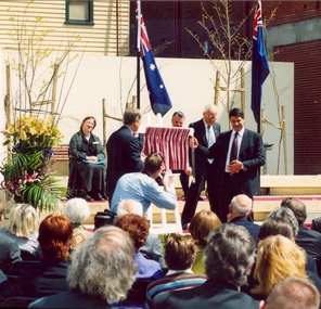
Photograph - Colour, Steve Bracks, Premier of Victoria, opens the University of Ballarat Arts Academy, Camp Street, 22/07/2008
... Precinct. As the functions of the former public buildings were.... As the functions of the former public buildings were moved elsewhere ...The University of Ballarat inherited the Camp Street Arts Precinct. As the functions of the former public buildings were moved elsewhere, the Victorian Government of the time recognised the importance of maintaining the heritage buildings and the opportunity to create a cultural precinct extending from the Art Gallery. The 19th century architecture along Lydiard Street and the dogleg bend of Camp Street define the precinct. With substantial financial assistance from both State and Commonwealth Governments, the Art Gallery Ballarat has been extended through to include the 1884 Police Station on Camp Street. The Post Office building (1864-1887) was acquired for the University. The 1904 and 1941 Courthouses and the c1900 Public Library building were also included. Two new buildings have been constructed. These six buildings will house the University's Visual and Performing Arts Programs.3 Panorama photograph of the opening of the University of Ballarat Arts Academy, Camp Street. .2 Poster .1) L to R Kerry Cox (Vice Chancellor); Brendan Nelson (Federal Minister - Education); Chancellor David Caro; Steve Bracks, Premier of Victoria. Photographer Ian Reiduniversity of ballarat, camp street, victorian government, commonwealth government, ballarat fine art gallery, police station, courthouse, public library, post office, art gallery ballarat -
 Warrnambool and District Historical Society Inc.
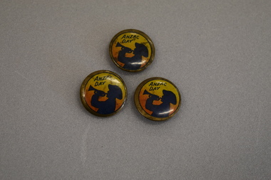
Badges, Anzac Day
... public buildings and at rallies held on or about ANZAC Day. ... sold on trams, buses, at railway stations, other public ...These badges were produced in World War One in Australia to raise funds for the war effort. ANZAC Day is an important national holiday in Australia commemorating the landing of Australian and New Zealand troops on Gallipoli on 25th April 1915. The national day was instituted on 25th April 1916 and badges such as these would have been sold on the anniversary of the landing day. Badges were sold on trams, buses, at railway stations, other public buildings and at rallies held on or about ANZAC Day. These badges are a significant reminder of the many fund raising activities held in Australia to raise funds for the war effort.Three circular slightly concave metal badges featuring the profile of an Australian soldier in a slouch hat blowing a bugle. The background depicts sunrise in yellow and orange colours and text. The outer edge is gold coloured . The reverse has a metal clip.ANZAC DAYanzac day, badges -
 Federation University Historical Collection
Photograph - Photograph - Colour, Ian Reid, Steve Bracks, Premier of Victoria, opens the University of Ballarat Arts Academy, Camp Street, 22/07/2008
... of the former public buildings were moved elsewhere, the Victorian... public buildings were moved elsewhere, the Victorian Government ...The University of Ballarat (later Federation University_ inherited the Camp Street Arts Precinct. As the functions of the former public buildings were moved elsewhere, the Victorian Government of the time recognised the importance of maintaining the heritage buildings and the opportunity to create a cultural precinct extending from the Art Gallery. The 19th century architecture along Lydiard Street and the dogleg bend of Camp Street define the precinct. With substantial financial assistance from both State and Commonwealth Governments, the Art Gallery Ballarat has been extended through to include the 1884 Police Station on Camp Street. The Post Office building (1864-1887) was acquired for the University. The 1904 and 1941 Courthouses and the c1900 Public Library building were also included. Two new buildings have been constructed. These six buildings will house the University's Visual and Performing Arts ProgramsColoured postcard size photograph of Steve Bracks, Premier of Victoria, unveiling the plaque at the opening of the University of Ballarat Arts Academy, Camp Street. .1) L to R Kerry Cox (Vice Chancellor); Brendan Nelson (Federal Minister - Education); Chancellor David Caro; Steve Bracks, Premier of Victoria. Photographer Ian Reiduniversity of ballarat, camp street, victorian government, commonwealth government, ballarat fine art gallery, police station, courthouse, public library, post office, art gallery ballarat, art gallery of ballarat -
 Kiewa Valley Historical Society
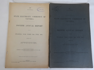
Books - SECV Annual Reports 1920-1948
... electricity for lighting of public buildings, street lighting... electricity for lighting of public buildings, street lighting ...28 books - SECV Annual Report covering the financial year with Appendices from March 1919 to June 1920 to year ending June 1948. Presented to Parliament pursuant to section 35 (b). The Victorian government owned the electrical company in Victoria supplying electricity for lighting of public buildings, street lighting and electrical trams. Brown coal was the main source of supply. The SECV commenced on 10th January 1921 having earlier been known as the Electricity Commissioners in 1919-1921. The SEC was privatised in the 1990s. The Kiewa Scheme was approved in 1937 but its start was delayed due to WWII. The reports include references to Kiewa Hydro Electric Scheme early on. The papers are a primary source as they were presented to Parliament as true documents and hence valuable for research.Foolscap pages held togeether by 2 or 3 staples at the spine.The cardboard cover is a blue grey with printed black title. Varying number of pages from perhaps 40 to 70. The reports are 'together with Appendices'. Also SEC 1951 logo transferssecv 1951 transfers, secv reports with appendices -
 Kew Historical Society Inc
Plan, Melbourne & Metropolitan Board of Works : Borough of Kew : Detail Plan No.1582, 1904
... ), weatherboard constructions (yellow), and public buildings (grey... (yellow), and public buildings (grey). Public buildings, coloured ...The Melbourne and Metropolitan Board of Works (MMBW) plans were produced from the 1890s to the 1950s. They were crucial to the design and development of Melbourne's sewerage and drainage system. The plans, at a scale of 40 feet to 1 inch (1:480), provide a detailed historical record of Melbourne streetscapes and environmental features. Each plan covers one or two street blocks (roughly six streets), showing details of buildings, including garden layouts and ownership boundaries, and features such as laneways, drains, bridges, parks, municipal boundaries and other prominent landmarks as they existed at the time each plan was produced. (Source: State Library of Victoria)This plan forms part of a large group of MMBW plans and maps that was donated to the Society by the Mr Poulter, City Engineer of the City of Kew in 1989. Within this collection, thirty-five hand-coloured plans, backed with linen, are of statewide significance as they include annotations that provide details of construction materials used in buildings in the first decade of the 20th century as well as additional information about land ownership and usage. The copies in the Public Record Office Victoria and the State Library of Victoria are monochrome versions which do not denote building materials so that the maps in this collection are invaluable and unique tools for researchers and heritage consultants. A number of the plans are not held in the collection of the State Library of Victoria so they have the additional attribute of rarity.Original survey plan, issued by the MMBW to a contractor with responsibility for constructing sewers in the area identified on the plan within the Borough of Kew. The plan was at some stage hand-coloured, possibly by the contractor, but more likely by officers working in the Engineering Department of the Borough and later Town, then City of Kew. The hand-coloured sections of buildings on the plan were used to denote masonry or brick constructions (pink), weatherboard constructions (yellow), and public buildings (grey). Public buildings, coloured grey on the Plan 1582 include the police station and post office, churches and schools. The earliest church school, Common School No.356 was located at the rear of the Congregational Church in Peel Street. It was constructed in 1859. The first buildings of Kew Primary School No.1075 on the other side of Peel Street were constructed in 1871. The school in 1903 only occupied a small fraction of its current site. In 1903, where the rear playground is now located, were two weatherboard and one brick villa. Trinity Grammar School was founded in 1902 and opened in the Parish Hall at the rear of Holy Trinity Anglican Church. It was not to move to its current site until 1906. The outline of the building housing the Kew Fire Brigade in the centre of the north side of Walton Street is shown but not named on the plan. Further down Pakington Street stood the two-storey Italianate mansion ‘Overton’. The home of Stanford Chapman, it was to be featured in the Imperial Institute series of bromide photographs of Victoria, Vol. 1: Homes and scenery. It was later to become a boarding house before it was later demolished.melbourne and metropolitan board of works, detail plans, maps - borough of kew, mmbw 1582, cartography -
 Linton and District Historical Society Inc
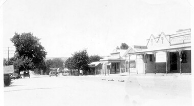
Photograph, Sussex Street, Linton - view to north, late 1920s or early 1930s
... Street. View of Railway Hotel, Nelson undertaker building, public... undertaker building, public library and "cash emporium". Cars parked ...Dated to late 1920s or early 1930s as Nelson building has been renovated as a Californian bungalow. The earlier curvilinear parapet on the library building (see photo - Registration no. 166) has been squared off, and a small pedimented timber parapet has been added above.Black and white photograph of Linton's main street, Sussex Street. View of Railway Hotel, Nelson undertaker building, public library and "cash emporium". Cars parked and driving along Sussex St."Linton Main Street".sussex street linton, railway hotel, nelson undertakers, linton public library, cash emporium, transport, cars -
 Kew Historical Society Inc
Plan, Melbourne & Metropolitan Board of Works : Borough of Kew : Detail Plan No.1592, 1905
... ), weatherboard constructions (yellow), and public buildings (grey...), weatherboard constructions (yellow), and public buildings (grey ...The Melbourne and Metropolitan Board of Works (MMBW) plans were produced from the 1890s to the 1950s. They were crucial to the design and development of Melbourne's sewerage and drainage system. The plans, at a scale of 40 feet to 1 inch (1:480), provide a detailed historical record of Melbourne streetscapes and environmental features. Each plan covers one or two street blocks (roughly six streets), showing details of buildings, including garden layouts and ownership boundaries, and features such as laneways, drains, bridges, parks, municipal boundaries and other prominent landmarks as they existed at the time each plan was produced. (Source: State Library of Victoria). This plan forms part of a large group of MMBW plans and maps that was donated to the Society by the Mr Poulter, City Engineer of the City of Kew in 1989. Within this collection, thirty-five hand-coloured plans, backed with linen, are of statewide significance as they include annotations that provide details of construction materials used in buildings in the first decade of the 20th century as well as additional information about land ownership and usage. The copies in the Public Record Office Victoria and the State Library of Victoria are monochrome versions which do not denote building materials so that the maps in this collection are invaluable and unique tools for researchers and heritage consultants. A number of the plans are not held in the collection of the State Library of Victoria so they have the additional attribute of rarity.Original survey plan, issued by the MMBW to a contractor with responsibility for constructing sewers in the area identified on the plan within the Borough of Kew. The plan was at some stage hand-coloured, possibly by the contractor, but more likely by officers working in the Engineering Department of the Borough and later Town, then City of Kew. The hand-coloured sections of buildings on the plan were used to denote masonry or brick constructions (pink), weatherboard constructions (yellow), and public buildings (grey). In MMBW Plan No.1592, the pink line indicates that area of the plan for which the contracting engineer was responsible. Included in the Plan are a number of primarily brick villas in a section of Belmont Avenue off Cotham Road. The house ‘Uvadale’ north of Belmont Avenue, and facing Cotham Road is also included in the contract. Excluded from the contract but shown on the Plan are ‘Glendonald’, ‘Mont Belmont’ and ‘Gilden’.melbourne and metropolitan board of works, detail plans, survey plans - borough of kew, mmbw 1592, cartography -
 Kew Historical Society Inc
Plan, Melbourne & Metropolitan Board of Works : Borough of Kew : Detail Plan No.1561, 1905
... ), weatherboard constructions (yellow), and public buildings (grey...), and public buildings (grey). MMBW Detail Plan 1561 outlines those ...The Melbourne and Metropolitan Board of Works (MMBW) plans were produced from the 1890s to the 1950s. They were crucial to the design and development of Melbourne's sewerage and drainage system. The plans, at a scale of 40 feet to 1 inch (1:480), provide a detailed historical record of Melbourne streetscapes and environmental features. Each plan covers one or two street blocks (roughly six streets), showing details of buildings, including garden layouts and ownership boundaries, and features such as laneways, drains, bridges, parks, municipal boundaries and other prominent landmarks as they existed at the time each plan was produced. (Source: State Library of Victoria). This plan forms part of a large group of MMBW plans and maps that was donated to the Society by Mr Poulter, City Engineer of the City of Kew in 1989. Within this collection, thirty-five hand-coloured plans, backed with linen, are of statewide significance as they include annotations that provide details of construction materials used in buildings in the first decade of the 20th century as well as additional information about land ownership and usage. The copies in the Public Record Office Victoria and the State Library of Victoria are monochrome versions which do not denote building materials so that the maps in this collection are invaluable and unique tools for researchers and heritage consultants. A number of the plans are not held in the collection of the State Library of Victoria so they have the additional attribute of rarity.Original survey plan, issued by the MMBW to a contractor with responsibility for constructing sewers in the area identified on the plan within the Borough of Kew. The plan was at some stage hand-coloured, possibly by the contractor, but more likely by officers working in the Engineering Department of the Borough and later Town, then City of Kew. The hand-coloured sections of buildings on the plan were used to denote masonry or brick constructions (pink), weatherboard constructions (yellow), and public buildings (grey). MMBW Detail Plan 1561 outlines those residences in the area bordered by Burke Road, Loxton Street, Mount Street and Barkers Road that had been constructed by 1905 when the land was surveyed. At this time, the area nearest Burke Road had been subdivided and developed whereas the lands to the west were as yet undeveloped. The houses represented are not named on the Plan.melbourne and metropolitan board of works, detail plans, mmbw 1561, cartography -
 The Beechworth Burke Museum
Geological specimen - Feldspathic Sandstone
... Sandstone features prominently in public buildings throughout... Sandstone features prominently in public buildings throughout ...Feldspathic arenites are sandstones that contain less than 90% quartz, and more feldspar than unstable lithic fragments, and minor accessory minerals.Feldspathic sandstones are commonly immature or sub-mature.These sandstones occur in association with cratonic or stable shelf settings. Feldspathic sandstones are derived from granitic-type, primary crystalline, rocks. If the sandstone is dominantly plagioclase, then it is igneous in origin Sandstone features prominently in public buildings throughout Victoria. Most of the sandstone used as dimension stone in the State came from three sources: the Heatherlie quarry in the Grampians (Silurian), the Bacchus Marsh area (Permian), and the Barrabool Hills near Geelong (Cretaceous).Sandstone features prominently in public buildings throughout Victoria, making this specimen special as it shows the materials used by Victorian building companies. Sandstone can also be crushed, crushed stone is used in the construction of roadways and road structures such as bridges, and in buildings, both commercial and residential. This specimen is part of a larger collection of geological and mineral specimens collected from around Australia (and some parts of the world) and donated to the Burke Museum between 1868-1880. A large percentage of these specimens were collected in Victoria as part of the Geological Survey of Victoria that begun in 1852 (in response to the Gold Rush) to study and map the geology of Victoria. Collecting geological specimens was an important part of mapping and understanding the scientific makeup of the earth. Many of these specimens were sent to research and collecting organisations across Australia, including the Burke Museum, to educate and encourage further study. A feldspar-rich sandstone, a sandstone intermediate in composition between an arkosic sandstone and a quartz sandstone, containing 10% to 25% feldspar and less than 20% matrix material of clay, sericite, and chlorite. Feldspathic arenite containing less than 90 percent of the composition of quartz. Feldspar is the main composition. Feldspathic arenite may contain fragments of unstable rock, and a little amount of other minerals such as mica and heavy minerals. Some feldspathic arenite have pink or red color because of the presence of potassium feldspar or iron oxide. There are also colored light gray to white. These sandstones are usually medium to coarse grained and can contain a high percentage of granules with angular until subangular roundness. The content of the matrix can appear as the rest up to more than 15 percent, and sorting of grains can present as moderate to poorly sorted. Feldspathic sandstones are generally immature in textural maturity. Feldspathic arenite can not be judged from the structure of the sediment. Bedding can emerge from the laminate parallel to the crossbed. Fossils may appear in the layer deposited on the sea. Feldspathic arenites usually appear on the craton or the continental shelf, which can be associated with conglomerate, quartz lithic arenite, carbonate rock, or evaporites. This sandstone may also appear on the succession of sedimentary basins deposited on an unstable or deep sea, and moving arc setting. According to Pettijohn (1963) Arkose make up about 15 percent of all sandstones. Some Arkose formed in situ when the granite and related rocks disintegrate and generate granular sediments. Most of the material feldspathic sandstones derived from primary crystalline granitic rocks, such as granite or metasomatic rocks containing abundant potassium feldspar. Mineral contained in sandstones is mostly a form of plagioclase feldspar derived from quartz diorite or volcanic rock. Feldspar contained on this sandstone comes from arid to cool climates when the chemical weathering process is reduced.sandstone, natural stone, feldspathic sandstone, burke museum, geology, geological, geological specimen -
 Linton and District Historical Society Inc
Document - Leaflet, How a Ten Pound Bond Pays
... . This notice was displayed in various public buildings, and the wording.... This notice was displayed in various public buildings, and the wording ...In the aftermath of World War 1, the Australian government aimed to raise 25 million pounds through the Second Peace Loan. Money raised was to be used for the repatriation and resettlement of former servicemen. Targets were set for money to be raised in each of the Australian states. This notice encouraged Victorians to help WWI returned servicemen through the purchase of peace bonds. It details the amount of interest a purchaser of a bond in the Second Peace Loan would receive after ten years. This notice was displayed in various public buildings, and the wording of the notice was also used in newspaper advertisements, for example this advertisement appeared in The Argus on 6 September 1920.Small cream coloured notice advertising the financial rewards to be gained through investment in peace bonds issued by the Australian government as part of the Second Peace Loan 1920.peace bonds, world war i, first world war -
 Mont De Lancey
Furniture - Cocktail Cabinet, Mr Franz Striezel, Unknown
... contributed to the wood carvings in public buildings and honour boards... contributed to the wood carvings in public buildings and honour boards ...This cocktail cabinet is part of a special bequest to the Mont De Lancey Museum of hand carved furniture and items made by Mr Franz Striezel by his grandaughter Mrs Dorothy Adamson. Dorothy was a friend of Nella Lord (nee Sebire). Dorothy passed away in 2007. It was to be known as The Franz Striezel Collection. Franz Streizel came from Germany in 1886 and was one of the three recognised craftsmen (Art Carvers) in Australia who contributed to the wood carvings in public buildings and honour boards throughout Australia. The National Gallery at their request had two small panels and a tobacco jar (some of his work), donated by Mrs D Adamson. They considered these pieces highly valuable.A beautifully hand carved ornate wooden cocktail cabinet featuring two female carved busts, carved mythical beasts on the front, sides and two doors of the cabinet underneath the drop down mirrored shelf. The shelf is attached by two gold linked chains screwed onto the sides. Two drawers at the top are elaborately decorated. The cupboard doors at the bottom open to show a shelf inside. This cabinet is part of a special bequest to the Mont De Lancey Museum of handcarved items made by Mr Franz Striezel by his grandaughter Mrs Dorothy Adamson. Dorothy was a friend of Nella Lord (nee Sebire). Dorothy passed away in 2007. It was to be known as The Franz Striezel Collection.On the top shelf, carved into the relief panels at the back is 'WELL BEFALL' and 'HEARTH HALL'bar equipment, cocktail cabinets, cabinets, furniture -
 Mont De Lancey
Furniture - Card Table, Franz Streizel, Unknown
... in public buildings and honour boards throughout Australia... contributed to the wood carvings in public buildings and honour boards ...This card table is part of a special bequest to the Mont De Lancey Museum of hand carved furniture and items made by Mr Franz Striezel by his grandaughter Mrs Dorothy Adamson. Dorothy was a friend of Nella Lord (nee Sebire). Dorothy passed away in 2007. It was to be known as The Franz Striezel Collection. Franz Streizel came from Germany in 1886 and was one of the three recognised craftsmen (Art Carvers) in Australia who contributed to the wood carvings in public buildings and honour boards throughout Australia. The National Gallery at their request had two small panels and a tobacco jar (some of his work), donated by Mrs D Adamson. They considered these pieces highly valuable.A handmade square wooden card table featuring an ornately patterned inlaid top of lighter coloured woods. It has a beautifully carved four legged base with a shelf at the bottom above the four clawed feet. The top lifts up to reveal a storage box below which is attached with screws to the base. The lid is attached with brass hinges and screws.furnitue, tables, card tables -
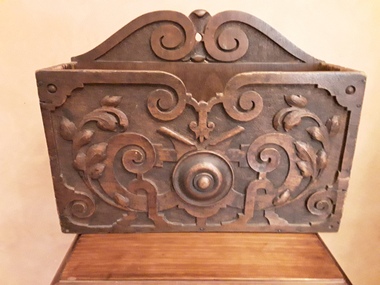 Mont De Lancey
Functional object - Magazine holder, Unknown
... contributed to the wood carvings in public buildings and honour boards... contributed to the wood carvings in public buildings and honour boards ...This magazine holder is part of a special bequest to the Mont De Lancey Museum of hand carved furniture and items made by Mr Franz Striezel by his grandaughter Mrs Dorothy Adamson. Dorothy was a friend of Nella Lord (nee Sebire). Dorothy passed away in 2007. It was to be known as The Franz Striezel Collection. Franz Streizel came from Germany in 1886 and was one of the three recognised craftsmen (Art Carvers) in Australia who contributed to the wood carvings in public buildings and honour boards throughout Australia. The National Gallery at their request had two small panels and a tobacco jar (some of his work), donated by Mrs D Adamson. They considered these pieces highly valuable.A highly decorated wooden hand carved rectangular magazine holder. The back of it is plain. functional objects, magazines, magazine holders -
 Warrnambool and District Historical Society Inc.
Pamphlet (Collection) - Warrnambool Tourist Maps, Warrnambool City Council, 1975 to 2002
... streets in Warrnambool, local amenities and public buildings... streets in Warrnambool, local amenities and public buildings ...Warrnambool Tourist Maps collected over the years by Warrnambool Historical Society membersPreservation of local maps for historical purposesEnclosed in A4 size plastic envelopes in an A4 size archival box and numbered and catalogued according to the date of acquisition.This collection has 16 pamphlets containing maps of Warrnambool and district and some accompanying printed materialwarrnambool tourism, city of warrnambool, shipwreck coast tourismwarrnambool tourism, city of warrnambool, shipwreck coast tourism -
 Kew Historical Society Inc
Plan, Melbourne & Metropolitan Board of Works : Borough of Kew : Detail Plan No.1302, 1910
... ), weatherboard constructions (yellow), and public buildings (grey...), and public buildings (grey). The absence of buildings ...The Melbourne and Metropolitan Board of Works (MMBW) plans were produced from the 1890s to the 1950s. They were crucial to the design and development of Melbourne's sewerage and drainage system. The plans, at a scale of 40 feet to 1 inch (1:480), provide a detailed historical record of Melbourne streetscapes and environmental features. Each plan covers one or two street blocks (roughly six streets), showing details of buildings, including garden layouts and ownership boundaries, and features such as laneways, drains, bridges, parks, municipal boundaries and other prominent landmarks as they existed at the time each plan was produced. (Source: State Library of Victoria)This plan forms part of a large group of MMBW plans and maps that was donated to the Society by the Mr Poulter, City Engineer of the City of Kew in 1989. Within this collection, thirty-five hand-coloured plans, backed with linen, are of statewide significance as they include annotations that provide details of construction materials used in buildings in the first decade of the 20th century as well as additional information about land ownership and usage. The copies in the Public Record Office Victoria and the State Library of Victoria are monochrome versions which do not denote building materials so that the maps in this collection are invaluable and unique tools for researchers and heritage consultants. A number of the plans are not held in the collection of the State Library of Victoria so they have the additional attribute of rarity.Original survey plan, issued by the MMBW to a contractor with responsibility for constructing sewers in the area identified on the plan within the Borough of Kew. The plan was at some stage hand-coloured, possibly by the contractor, but more likely by officers working in the Engineering Department of the Borough and later Town, then City of Kew. The hand-coloured sections of buildings on the plan were used to denote masonry or brick constructions (pink), weatherboard constructions (yellow), and public buildings (grey). The absence of buildings and or property in Kew facing the Yarra is the most notable feature of this plan. Walmer Street and its bridge stretched, then and now, from Studley Park Road to Victoria Street, Richmond. On the Richmond side of the Yarra, there was evidence in 1904 of industry (‘Wool shed’; Soap Works’) and entertainment (‘Skittle Alley’). In reality, another Plan (No.1303) shows Chinese Gardens bordering the Yarra on the Kew side and buildings in Young Street.melbourne and metropolitan board of works, detail plans, mmbw 1302, cartography -
 Kew Historical Society Inc
Plan, Melbourne & Metropolitan Board of Works : Borough of Kew : Detail Plan No.1571, 1904
... ), weatherboard constructions (yellow), and public buildings (grey...), and public buildings (grey). This plan is the other half of Plan ...The Melbourne and Metropolitan Board of Works (MMBW) plans were produced from the 1890s to the 1950s. They were crucial to the design and development of Melbourne's sewerage and drainage system. The plans, at a scale of 40 feet to 1 inch (1:480), provide a detailed historical record of Melbourne streetscapes and environmental features. Each plan covers one or two street blocks (roughly six streets), showing details of buildings, including garden layouts and ownership boundaries, and features such as laneways, drains, bridges, parks, municipal boundaries and other prominent landmarks as they existed at the time each plan was produced. (Source: State Library of Victoria)This plan forms part of a large group of MMBW plans and maps that was donated to the Society by the Mr Poulter, City Engineer of the City of Kew in 1989. Within this collection, thirty-five hand-coloured plans, backed with linen, are of statewide significance as they include annotations that provide details of construction materials used in buildings in the first decade of the 20th century as well as additional information about land ownership and usage. The copies in the Public Record Office Victoria and the State Library of Victoria are monochrome versions which do not denote building materials so that the maps in this collection are invaluable and unique tools for researchers and heritage consultants. A number of the plans are not held in the collection of the State Library of Victoria so they have the additional attribute of rarity.Original survey plan, issued by the MMBW to a contractor with responsibility for constructing sewers in the area identified on the plan within the Borough of Kew. The plan was at some stage hand-coloured, possibly by the contractor, but more likely by officers working in the Engineering Department of the Borough and later Town, then City of Kew. The hand-coloured sections of buildings on the plan were used to denote masonry or brick constructions (pink), weatherboard constructions (yellow), and public buildings (grey). This plan is the other half of Plan No.1571 representing the constructions to the west of Wellington Street before and in 1903/4. This plan represents the built environment in Edgevale Road, Wellington Street, Atkins Street, Annadale Street, Mortimer Street, and Cotham Road. Whereas there are smaller allotments and more modest housing stock facing Edgevale Road, larger blocks and more substantial houses are represented facing Cotham Road.melbourne and metropolitan board of works, detail plans, mmbw 1571, cartography -
 Kew Historical Society Inc
Plan, Melbourne & Metropolitan Board of Works : Borough of Kew : Detail Plan No.1575, 1905
... ), weatherboard constructions (yellow), and public buildings (grey... (yellow), and public buildings (grey). Plan No.1575 shows ...The Melbourne and Metropolitan Board of Works (MMBW) plans were produced from the 1890s to the 1950s. They were crucial to the design and development of Melbourne's sewerage and drainage system. The plans, at a scale of 40 feet to 1 inch (1:480), provide a detailed historical record of Melbourne streetscapes and environmental features. Each plan covers one or two street blocks (roughly six streets), showing details of buildings, including garden layouts and ownership boundaries, and features such as laneways, drains, bridges, parks, municipal boundaries and other prominent landmarks as they existed at the time each plan was produced. (Source: State Library of Victoria)This plan forms part of a large group of MMBW plans and maps that was donated to the Society by the Mr Poulter, City Engineer of the City of Kew in 1989. Within this collection, thirty-five hand-coloured plans, backed with linen, are of statewide significance as they include annotations that provide details of construction materials used in buildings in the first decade of the 20th century as well as additional information about land ownership and usage. The copies in the Public Record Office Victoria and the State Library of Victoria are monochrome versions which do not denote building materials so that the maps in this collection are invaluable and unique tools for researchers and heritage consultants. A number of the plans are not held in the collection of the State Library of Victoria so they have the additional attribute of rarity.Original survey plan, issued by the MMBW to a contractor with responsibility for constructing sewers in the area identified on the plan within the Borough of Kew. The plan was at some stage hand-coloured, possibly by the contractor, but more likely by officers working in the Engineering Department of the Borough and later Town, then City of Kew. The hand-coloured sections of buildings on the plan were used to denote masonry or brick constructions (pink), weatherboard constructions (yellow), and public buildings (grey). Plan No.1575 shows that in the area bounded by Wellington Street, Edgevale Road, Glenferrie Road, and Cotham Road, there had already been significant subdivision of land and houses constructed. As one of the highest points in Kew, as expected, there were already some significant mansions built on large allotments of land. Many of these mansions are identified by name on the plan such as ‘Kelso’, ‘Abbotsford’, ‘Clarendon’ and ‘Ashlyn’ in Cotham Road. Other houses of equal size are unnamed on the plan.melbourne and metropolitan board of works, detail plans, maps - borough of kew, mmbw 1575, cartography -
 Orbost & District Historical Society
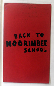
magazine, Back To Noorinbee School, 1974-1975
... . It was the first public building for the Cann Valleyand was first used.... It was the first public building for the Cann Valleyand was first used ...Noorinbee School, situated on the Bombala Rd approximately 6.5 km north of Cann River, was opened on 26th of July 1900, with Albert Le Page as head teacher until 30th of September 1904. The school still functions. A school bus runs daily to take the older children to the central classes at Cann River. "Noorinbee" is an Aboriginal word of unknown origin, The historical school is still at the front of the school yard. The Old Noorinbee School was been shifted twice. The first time they used a bullock team in 1924. The second time they used trucks and tractors in 1991. It was the first public building for the Cann Valleyand was first used as a hall and a church until it became the Noorinbee school in 1900. It was built in 1898. This item is a useful reference / research tool for the history of Noorinbee and its surrounds.A stapled paper back magazine with a red cover which has the title "BACK TO NOORINBEE SCHOOL" in black print. It contains a collection of articles relating to Orbost and Noorinbee and contains examples of children's work.noorinbee magazine-back-to-noorinbee-school -
Tatura Irrigation & Wartime Camps Museum
Photograph, Female Office in Mustard Uniform - caricature, 1941-1946
... public buildings in Murchison.... Jones Nursing home and other public buildings in Murchison. hans ...Hans Walter von Gruenewaldt was a German POW who used his artistic ability to paint several large mural caricatures whilst he was held at Camp 13 at Murchison. The technique he used was colourful house paint, painted directly onto the walls of the German mess hut, reading room and recreation hall. After the war, the recreation hall paintings and all, was moved from the camp to the nearly town of Murchison and used as the RSL local dance hall for 50 years. When the hall was demolished the paintings were restored and framed by citizens of Murchison. The von Gruenewaldt murals presently hang in the David Jones Nursing home and other public buildings in Murchison.Photograph of caricature painted on mess hut wall. Female office in mustard uniform with green hat. The office is accompanied by a dog (coloured). hans walter von gruenewaldt, german pow, internment camp 13, murchison victoria, caricatures -
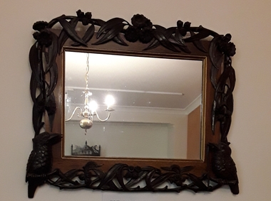 Mont De Lancey
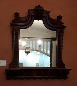
Functional object - Mirror, Franz Streizel, Unknown
... contributed to the wood carvings in public buildings and honour boards... contributed to the wood carvings in public buildings and honour boards ...This hand carved framed mirror is part of a special bequest to the Mont De Lancey Museum of hand carved furniture and items made by Mr Franz Striezel by his grandaughter Mrs Dorothy Adamson. Dorothy was a friend of Nella Lord (nee Sebire). Dorothy passed away in 2007. It was to be known as The Franz Striezel Collection. Franz Streizel came from Germany in 1886 and was one of the three recognised craftsmen (Art Carvers) in Australia who contributed to the wood carvings in public buildings and honour boards throughout Australia. The National Gallery at their request had two small panels and a tobacco jar (some of his work), donated by Mrs D Adamson. They considered these pieces highly valuable.An elaborately carved wooden framed mirror with two carved kookaburras, one with a lizard in its beak as well as some Australian flora - eucalyptus leaves, flowers and gumnuts around the edges of the frame.mirrors, functional objects, wall mirrors, objects -
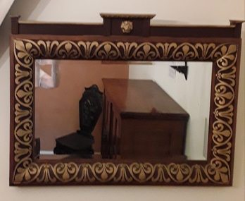 Mont De Lancey
Functional object - Mirror, Franz Streizel, Unknown
... contributed to the wood carvings in public buildings and honour boards... contributed to the wood carvings in public buildings and honour boards ...This hand carved framed mirror is part of a special bequest to the Mont De Lancey Museum of hand carved furniture and items made by Mr Franz Striezel by his grandaughter Mrs Dorothy Adamson. Dorothy was a friend of Nella Lord (nee Sebire). Dorothy passed away in 2007. It was to be known as The Franz Striezel Collection. Franz Streizel came from Germany in 1886 and was one of the three recognised craftsmen (Art Carvers) in Australia who contributed to the wood carvings in public buildings and honour boards throughout Australia. The National Gallery at their request had two small panels and a tobacco jar (some of his work), donated by Mrs D Adamson. They considered these pieces highly valuable.A rectangular beautifully carved wooden framed mirror featuring a gold painted carved lion head at the top and gold painted crest shaped ornamentation around the edges of the frame.mirrors, functional objects, wall mirrors, objects -
 Mont De Lancey
Functional object - Mirror, Franz Streizel, Unknown
... contributed to the wood carvings in public buildings and honour boards... contributed to the wood carvings in public buildings and honour boards ...This hand carved framed mirror is part of a special bequest to the Mont De Lancey Museum of hand carved furniture and items made by Mr Franz Striezel by his grandaughter Mrs Dorothy Adamson. Dorothy was a friend of Nella Lord (nee Sebire). Dorothy passed away in 2007. It was to be known as The Franz Striezel Collection. Franz Streizel came from Germany in 1886 and was one of the three recognised craftsmen (Art Carvers) in Australia who contributed to the wood carvings in public buildings and honour boards throughout Australia. The National Gallery at their request had two small panels and a tobacco jar (some of his work), donated by Mrs D Adamson. They considered these pieces highly valuable.An ornately hand carved rectangular wooden framed mirror with a shelf at the bottom and a carved ancient Egyptian style head in the middle of the frame at the top. There are two carved gargoyles on each top side. The mirror glass is shaped.mirrors, functional objects, wall mirrors, objects -
 Mont De Lancey
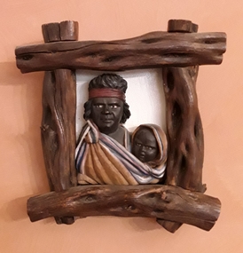
Decorative object, Franz Streizel, Indigenous Carved Pictures
... ) in Australia who contributed to the wood carvings in public buildings...) in Australia who contributed to the wood carvings in public buildings ...These hand carved framed wooden pictures are part of a special bequest to the Mont De Lancey Museum of hand carved furniture and items made by Mr Franz Striezel by his grandaughter Mrs Dorothy Adamson. Dorothy was a friend of Nella Lord (nee Sebire). Dorothy passed away in 2007. It was to be known as The Franz Striezel Collection. Franz Streizel came from Germany in 1886 and was one of the three recognised craftsmen (Art Carvers) in Australia who contributed to the wood carvings in public buildings and honour boards throughout Australia. The National Gallery at their request had two small panels and a tobacco jar (some of his work), donated by Mrs D Adamson. They considered these pieces highly valuable.Two hand carved Indigenous busts in wood frames.1: A mother wearing a headband and striped gold, white blue and pink painted clothes draped over a baby. Only the face of the baby is depicted. 2: A father's upper body bust also has clothes draped over the baby he is holding. Both are framed using natural sticks which are painted brown on a white backfround.wood carvings, carvings, portraits, artworks, objects -
 Mont De Lancey
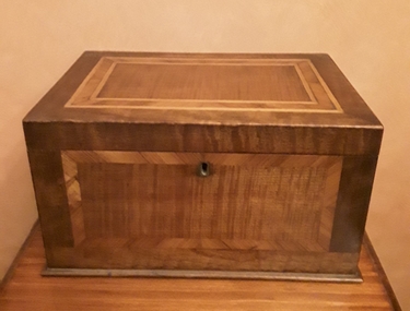
Functional object - Box, Mr Franz Streizel, Unknown
... ) in Australia who contributed to the wood carvings in public buildings...) in Australia who contributed to the wood carvings in public buildings ...This lockable wooden inlaid box is part of a special bequest to the Mont De Lancey Museum of hand carved furniture and items made by Mr Franz Striezel by his grandaughter Mrs Dorothy Hilda Adamson. Dorothy was a friend of Nella Lord (nee Sebire). Dorothy passed away in 2007. It was to be known as The Franz Striezel Collection. Franz Streizel came from Germany in 1886 and was one of the three recognised craftsmen (Art Carvers) in Australia who contributed to the wood carvings in public buildings and honour boards throughout Australia. The National Gallery at their request had two small panels and a tobacco jar (some of his work), donated by Mrs D Adamson. They considered these pieces highly valuable.A lockable rectangular handmade lidded wooden box with inlaid patterned wood panels on each side and the lid. It has red velvet lining inside the lid and inner base. There is a lift our red velvet lined wooden tray. The lid is attached with brass hinges. Keys for the inlaid cabinet in the same room are stored in the tray in this box.L W is written in grey pencil on the base of the box.boxes, objects, containers, storage boxes -
 Mont De Lancey
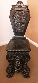
Furniture - Nursing Chair, Mr Franz Streizel, Unknown
... contributed to the wood carvings in public buildings and honour boards... contributed to the wood carvings in public buildings and honour boards ...This nursing chair is part of a special bequest to the Mont De Lancey Museum of hand carved furniture and items made by Mr Franz Striezel by his grandaughter Mrs Dorothy Hilda Adamson. Dorothy was a friend of Nella Lord (nee Sebire). Dorothy passed away in 2007. It was to be known as The Franz Striezel Collection. Franz Streizel came from Germany in 1886 and was one of the three recognised craftsmen (Art Carvers) in Australia who contributed to the wood carvings in public buildings and honour boards throughout Australia. The National Gallery at their request had two small panels and a tobacco jar (some of his work), donated by Mrs D Adamson. They considered these pieces highly valuable. An ornately hand carved dark wooden heavy nursing chair with a carved figure of a child and gargoyles on the front of the back rest. The seat is highly patterned too. The back and front legs are carved in one enclosed piece of wood with a gargoyle face and spirals on them.chairs, nursery furniture, nursing chairs, seating furniture -
 Eltham District Historical Society Inc
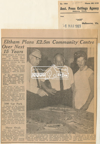
Newspaper Clipping, Eltham Plans £2.5m Community Centre Over Next 15 Years, The Age, 6 March 1963 page 7, 1963
... for a business centre, public buildings and recreational reserves... for a business centre, public buildings and recreational reserves ...Eltham Plans £2.5m Community Centre Over Next 15 Years THE people of Eltham have drawn up a plan to make their township a model community centre in the next 15 years. And yesterday the Chief Secretary (Mr Rylah) inspected the plan at the Eltham shire offices before declaring it open for public inspection In the picture (right) Mr. Rylah (centre) is shown inspecting the new plan with town planner and former councillor, Mr. Howard Bartlett, and the shire president, Cr. C. Pelling. The result of six years' work by shire officers, the plan provides for a business centre, public buildings and recreational reserves. The shire council expects that £2,500,000 will be invested by Government departments, banks, private firms and sporting bodies to implement the plan. 500 Car Park A feature of the business centre will be a quadrangle car park surrounded by shops, and with parking space for 500 cars. The public buildings will include new municipal offices, a public auditorium, a library and meeting rooms. The council plans to realign the course of Diamond Creek near the town to provide extra land for playing fields. Three Ovals The plan proposes three ovals, including improvements to an existing one, as well as a 50-metre Olympic swimming pool, tennis courts and bowling greens. In the 15 years which the shire council hopes to carry out the plan, the shire population of 18,000 is expected to increase two and a half times. Opening the display of maps and a model, Mr. Rylah said he commended the shire council's invitation to the citizens to suggest improvements to the plan. Eltham shire had grown tremendously in the past 20 years, from a sleepy country town to an important shopping centre. Digital file only of copy provided on loanauditorim, bowlong green, charis pelling, eltham community centre, rylah, howard bartlett, car park, library, forward plan -
 Linton and District Historical Society Inc
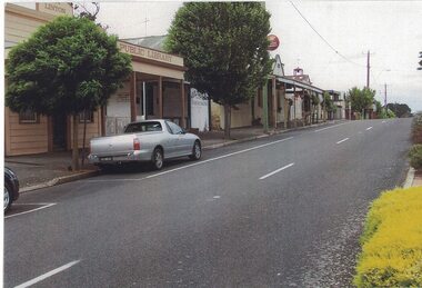
Photograph, East Side of Sussex Street, Linton, 2014
... Linton Public Library building... to the south along the east side of Sussex Street. The former public...Linton Public Library building Linton & District Historical ...One of three colour photographs which have been printed on a single sheet of photographic paper. The photograph shows the view to the south along the east side of Sussex Street. The former public library building, the Historical Society building (formerly Nelson Bros Undertakers), the Railway Hotel, the former CFA building and other shops and houses can be seen on the left of the photograph, which was taken by Gary Hunt in 2014.linton public library building, linton & district historical society resource centre building, railway hotel linton, cfa building linton, sussex street linton