Showing 188 items matching "rail crossings"
-
 Eltham District Historical Society Inc
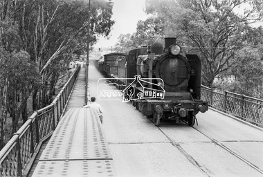
Photograph, Steam locomotive K-168 crossing the Echuca-Moama Road Rail Bridge over the Murray River, c.May 1963, 1963
Looking south into Echuca, VictoriaDigital TIFF file Scan of 35mm Ilford FP3 black and white negative transparencyechuca-moama road rail bridge, george coop collection, k-168, k-class steam locomotive (vr newport workshops), murray river -
 Eltham District Historical Society Inc
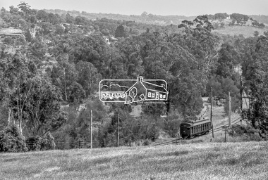
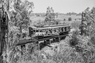
Photograph, George Coop, Single Motor Carriage (Red Rattler) Tait train, possibly 471M, heading for Eltham near Allendale Road, Diamond Creek, c.December 1980, 1980
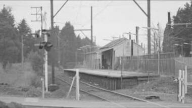
View is looking northwest from the hillside just north of Allendale Road. The long rectangular house in the upper left is No. 22 Challenger Street, Diamond Creek, right at the sharp turn into Price Court. On the track in the straight section heading northwest are two small bridges where the track crosses the Diamond Creek, each fitted with derailment guard rails to prevent severe derailments should a train come off the tracks whilst crossing the culverts. Digital TIFF file Scan of 35mm Ilford FP4 black and white transparency471m, allendale road, challenger street, derailment guard rail, diamond creek, hurstbridge line, price court, red rattler, red rattler single carriage, single motor carriage, tait train -
 Eltham District Historical Society Inc
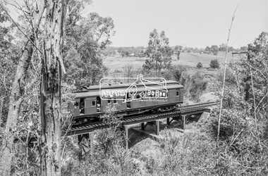
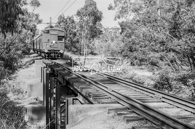
Photograph, George Coop, Single Motor Carriage 471M (Red Rattler) Tait train crossing over the Diamond Creek just north of Allendale Road, c.December 1980, 1980
Digital TIFF file Scan of 35mm Ilford FP4 black and white transparency471m, allendale road, derailment guard rail, diamond creek, hurstbridge line, railway bridge, red rattler, red rattler single carriage, single motor carriage, tait train -
 Eltham District Historical Society Inc
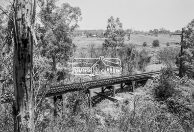
Photograph, George Coop, Railway bridge crossing over the Diamond Creek just north of Allendale Road, c.December 1980, 1980
Digital TIFF file Scan of 35mm Ilford FP4 black and white transparencyallendale road, derailment guard rail, diamond creek, hurstbridge line, railway bridge -
 Eltham District Historical Society Inc
Photograph, George Coop, Single Motor Carriage 471M (Red Rattler) Tait train heading for Eltham crossing over the Diamond Creek just north of Allendale Road, c.December 1980, 1980
Digital TIFF file Scan of 35mm Ilford FP4 black and white transparency471m, allendale road, derailment guard rail, diamond creek, hurstbridge line, railway bridge, red rattler, red rattler single carriage, single motor carriage, tait train -
 Eltham District Historical Society Inc
Photograph, George Coop, Single Motor Carriage (Red Rattler) Tait train heading for Eltham crossing over the Diamond Creek just north of Allendale Road, c.1981, 1981
Digital TIFF file Scan of 35mm Ilford FP4 black and white transparencyallendale road, derailment guard rail, diamond creek, railway bridge, single motor carriage, tait train -
 Federation University Historical Collection
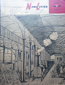
Magazine - Newsletter, Victorian Railways Newsletter, June 1967, 06/1957
Soft covered magazine of 16 pages. It includes an article of the Geelong Line centenary, and a photo of the original Geelong line laid with Barlow, or saddle-back rail; cement, Little River Station, , Renewing crossings, , memorial to railways returned servicement at the Ballarat NOrth Workkshops. victorian railwat, geelong railway centenary, cement, cp vans, railcrossings, trains -
 Greensborough Historical Society
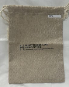
Memorabilia - Bag, Hurstbridge Line Duplication : delivered by Level Crossing Removal Project, 2023
Given out at the opening of Montmorency Railway Station 2023.Draw string fabric bag.'H' Hurstbridge Line Duplication; Delivered by Level Crossing Removal Project.bags, montmorency railway station, montmorency station, hurstbridge rail line upgrade -
 Greensborough Historical Society
Photograph - Digital Image, Watsonia Railway Station 1975, 1975_
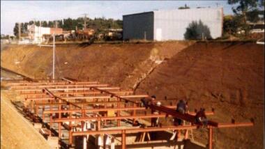
Watsonia rail line being moved below road level mid 1970s. This photograph shows work on the cutting and beginning of station. Watsonia Station was opened in 1977 when the rail line was lowered to remove level crossings and duplicate the line between Macleod and Greensborough.Digital copy of colour photographwatsonia station, hurstbridge rail line -
 Greensborough Historical Society
Photograph - Digital Image, Watsonia Railway Station before 1970, 1960s
Watsonia Station before the 1970s. This photograph shows the old station. The new Watsonia Station was opened in 1977 when the rail line was lowered to remove level crossings and duplicate the line between Macleod and Greensborough.Digital copy of black and white photographwatsonia station, hurstbridge rail line -
 Greensborough Historical Society
Photograph - Digital Image, Building Watsonia Station 1975, 1975_
Building Watsonia Station circa 1975. This photograph shows the framework for the new station being installed. The new Watsonia Station was opened in 1977 when the rail line was lowered to remove level crossings and duplicate the line between Macleod and Greensborough.Digital copy of colour photographwatsonia station, hurstbridge rail line -
 Greensborough Historical Society
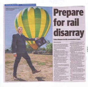
Newspaper Clipping, Diamond Valley Leader, Prepare for rail disarray, 14/03/2018
Roads will be thrown into chaos when a chunk of the Hurstbridge train line is closed for six weeks for track upgrades and the level crossing removal at Rosanna station.News article 1 page, black text and colour image .level crossing removal project, hurstbridge train line closure, rosanna station, hurstbridge rail line -
![Newspaper Clipping, Bridge is rail big effort [Rosanna], 11/04/2018](/media/collectors/4f729f5697f83e03086015b8/items/5aed3a8221ea670268548c06/item-media/5b4ad49921ea670f143ddf21/item-fit-380x285.jpg) Greensborough Historical Society
Greensborough Historical SocietyNewspaper Clipping, Bridge is rail big effort [Rosanna], 11/04/2018
... Removal Authority contractors. level crossing removal project rail ...The mammoth rail bridge has been installed across Lower Plenty Road in Rosanna by Level Crossing Removal Authority contractors.News article 1 page, black text and colour image .level crossing removal project, rail bridge, lower plenty road rosanna, rosanna station, hurstbridge rail line -
 Greensborough Historical Society
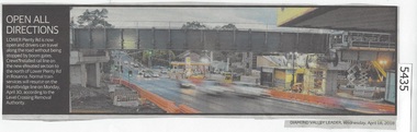
Newspaper Clipping, Diamond Valley Leader, Open all directions, 18/04/2018
Lower Plenty Road is now open and drivers can travel along the road without being stopped by boom gates at Rosanna Station.News article 1 page, black text and colour image .level crossing removal project, lower plenty road rosanna, rosanna station, hurstbridge rail line -
 Greensborough Historical Society
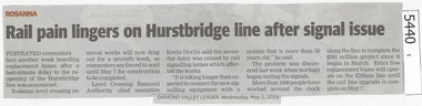
Newspaper Clipping, Diamond Valley Leader, Rail pain lingers on Hurstbridge line after signal issue, 02/05/2018
Frustrated commuters face another week boarding replacement buses after a last-minute delay to the re-opening of the Hurstbridge line was announced.News article 1 page, black text.level crossing removal project, rosanna station, hurstbridge rail line -
 Greensborough Historical Society
Photograph - Digital Image, Grimshaw Street level crossing, 1970s
The level crossing at Grimshaw Street Greensborough circa 1970s. The train line now crosses under Grimshaw Street with the lowering of the train line through Watsonia.Digital copy of black and white photograph.grimshaw street greensborough, husrstbridge rail line -
 Greensborough Historical Society
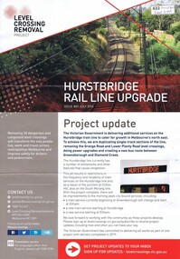
Leaflet, Level Crossing Removal Project: Hurstbridge Rail Line Upgrade. Issue #1, July 2016, July 2016
... Level Crossing Removal Project: Hurstbridge Rail Line... 2022- . level crossing removal project hurstbridge rail line ...Updates and information sheets on changes to train infrastructure and services on the Hurstbridge line as part of the Victorian Government's Level Crossing Removal Project. Includes the Hurstbridge Line Duplication Updates 2022- .Bulletins vary with regard to size and numbering; most have colour illustrations. Includes separate leaflet about FAQs on Planning Scheme Amendment required to conduct project works associated with the Hurstbridge Line Upgrade.level crossing removal project, hurstbridge rail line -
 Orbost & District Historical Society
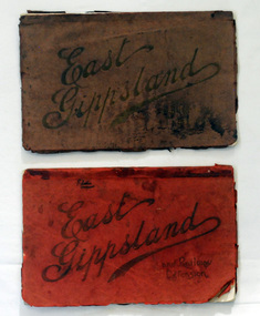
magazines, Atlas Press Pty Ltd, East Gippsland & Railway Extension, 10 September 1908
Orbost and East Gippsland Railway League had proposed a railway extension through East Gippsland in 1908, which aimed to develop an isolated part of the country. At the time, construction of a railway could be considered a beneficial investment for the country as it could increase the population in the region. The proposed railway length in 1908 was about 140 miles and the cost was estimated £800,000. The line was proposed to proceed from Bairnsdale by way of the Lower Nicholson to Bruthen. “After crossing the Tambo River, it would be carried to near Nowa Nowa; the head of Lake Tyers, forward to Orbost. From Orbost it would proceed in a north-easterly way to the New South Wales border. There were different suggested routes between Orbost and the New South Wales border, the first was through Bendoc, another by the Cann River and another which is located between these two. This item is associated with the history of the Orbost-Bairnsdale railway line and therefore reflects the role that the rail line played in the social and economic history of Orbost. The Bairnsdale-Orbost railway was opened in 1916 to serve the agricultural and timber industry. Because of the decline in traffic and heavy operating costs, the line was finally closed in August, 1987. Two small magazines showing the railway extension through East Gippsland. 678.1 has a dark maroon cover with gold print writing. It contains b/w photographs. 678.2 has a red cover with black print writing. Both are bound. 678.1 - inside front cover - M. Beattie ???????? Newmerella 678.2 - inside front cover - Gordon Fisher Orbosteast-gippsland-railway-league railway -
 Glen Eira Historical Society
Magazine - Henshaw, Cyril H
This file contains one item. 1. A copy of the ‘Australian Railway Enthusiast Vol. 22, No. 3’, Train Watching pp.4-11. In this article Mr Henshaw refers in part to his early life as a resident in Ormond and describes the rail transport that served the Glen Eira area.caulfield, ormond, katandra road, ormond siding, railways, rosstown railway, bambra road, booran road, marara road, ormond park, ormond junction cricket club, ormond station, north road, glenhuntly, carnegie, cinemas, crystal palace cinema, railway stations, ormond railway station, bentleigh railway station, mckinnon railway station, glenhuntly railway station, trains, steam trains, railway carriages, caulfield council, councillors, councillor stick, railway crossing, north road railway crossing -
Federation University Historical Collection
Report, Fast Rail Links to Regional Centres Feasibility Studies: Final Report, c2000
... crossings country rail lines rail gauge trains Ringbound Linking ...Used by the local branch of the Public Transport Users AssociationRingbound Linking Victoria report of 228 pages steve bracks, transport, linking victoria, railway, fast rail, ballarat corridor, bendigo corridor, traralgon corridor, geelong corridor, level crossings, country rail lines, rail gauge, trains -
Federation University Historical Collection
Book, Environment Victoria, Driving the Fast Train Further: Integrated Public Transport Across All Victoria, 2001, 05/2001
... corridor level crossings country rail lines ararat rail line trains ...Used by the local branch of the Public Transport Users Association.Yellow soft covered 36 page book outlining the feasibility of a Fast Train for Victoria.transport, linking victoria, railway, fast rail, ballarat corridor, bendigo corridor, traralgon corridor, geelong corridor, warrnambool corridor, level crossings, country rail lines, ararat rail line, trains -
 City of Moorabbin Historical Society (Operating the Box Cottage Museum)
Photograph, Black & White Postcard, Cheltenham Railway Station c1920, c1920
Although the Railway line had been planned for some time Sir Thomas Bent MP was responsible for making it happen in order to revitalize the fortunes of the Moorabbin Shire that he had represented for so long. The train line opened in 1881with 8 Stations between Caulfield and Mordialloc.The first Steam engine carried dignitaries and local residents. Bent also ensured that the Station houses in his constituency were built in a distinctive decorative cottage style. Bent faced severe criticism for diverting the rail line through his local area and for the expenditure on the Stations. Local residents established and cared for Gardens at the Stations and Cheltenham was awarded Best Garden c1910. The arrival of the Railway Line saw the traders move from Point Nepean Rd to Charman Rd and by 1910 various shops and business were present. 2016 - current has seen large protest rallies against the destruction of Mentone Station and Cheltenham Station as the Victorian State Government proceeds to remove Railway Level Crossings. A compromise to retain the Station buildings whilst placing the Rail Line underground is desired.Cheltenham Railway Station is one of the original cottage style stations ordered by Sir Thomas Bent when the rail line was extended from Caulfield to Mordialloc 1881Photograph Black & White Postcard showing the entrance to Cheltenham Railway Station c1920Valentine &Sons Pub Co Ltd Melb railways, cheltenham station, mentone station, south brighton station, railway level crossing removal 2016 -19, smith j l; smith mary ann, stanley helen, smith vic, smith harry redvers, chaff cutter, horse drawn carts, toll gates brighton, motor cars 1900, steam engines, early settlers, bentleigh, parish of moorabbin, city of moorabbin, county of bourke, moorabbin roads board, shire of moorabbin, henry dendy's special survey 1841, were j.b.; bent thomas, o'shannassy john, king richard, charman s, highett william, ormond francis, maynard dennis, market gardeners, vineyards, orchards -
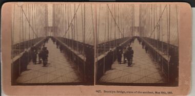 Bendigo Historical Society Inc.
Photograph - HARRIS COLLECTION: STEREOSCOPIC VIEWS, Nineteenth Centur
Stereoscopic views. Kilburn Brothers Littleton , N H. 1. Trinity college Dublin. 2. Brooklyn Bridge, scene of the accident , May 30th 1883. 3. Spinning Room , Mechanics Mill, Fall River Mass. 4. Bay Grove Hill, Greenwood Cemetery, Brooklyn, N Y. 5.Crossing the Great Suspension Bridge, by rail. 6. Dining Hall , Grand Union Hotel, Saratoga, Largest Dining Hall in the World. 7. Phantom Leaves. 8. Full Moon. 9. Merced River, Yo-Semite , Cal. 10. I Breathe Inspiration. 11. United States Hotel Park, Saratoga.Kilburn Brothers Littleton N H.photography, viewers -
Tatura Irrigation & Wartime Camps Museum
Photograph, Cattanach Canal, 1957
Taken by the photographer for Victoria State Rivers and Water Supply Commission.Large sepia photograph - Construction equipment middle foreground, two bridges, truck crossing second bridge, trees, flat paddock, scattered trees, man working on nearer concrete bridge support.Below photo: "Cattanach Canal / Rail and Highway Bridges near Murchison"irrigation, victoria state rivers and water supply commission, cattanach canal, bridges -
Tatura Irrigation & Wartime Camps Museum
Booklet, Newsrail - May 1992, 1992
Contains photographs of country rail trains. Includes accident of Brill Railcar (known as the "Beetle") at a level crossing on Toolamba-Echuca line 1949, at ByrnesideOn Front cover - Central Highlands Tourist Railways' 91RM rounds a curb as it heads towards Dayelsford after a trip to Musk. Sunday 15.9.91. Ads for model trains on back cover. newsrail - may 1992, vr rail motors, potts d, small w, victorian railways -
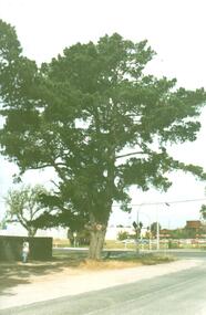 Hume City Civic Collection
Photograph, Early 1990's
The photograph was taken after Coles Supermarket and Sunbury Shopping Square were constructed on the railway land on the east side of the line in 1989, but before the Safeway-Woolworths complex was built in 2000 on the west side of the railway line. The open land on the west side of the line was used by rail communters as a car park.A coloured photograph showing part of the T intersection at Cornish and Horne Streets. A large pine tree is growing at the corner immediately in front of a pedestrian crossing. The railway car park, metal water tower and Coles Supermarket are in the background. A boy is walking along the footpath.cornish street, horne street, water towers, coles supermarket, sunbury railway station, george evans collection -
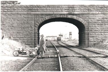 Hume City Civic Collection
Photograph, Pre 1989
... crossing. road over rail bridge bridges sunbury railway station ...The bluestone 'road over rail' bridge at Macedon Street is of state architectural, architectural, historical and engineering significance. It spans the first government regional railway. Its design and building was done according to strict English standards and made use of a bridge crossing instead of a level road crossing.A black and white photograph of a stone bridge with an eliptical arch spanning two rail tracks. A workman is standing between one set of tracks in the foreground and a railcart is next to the tracks. The station, footbridge and water tower are visible through the arch.road over rail bridge, bridges, sunbury railway station, water towers, pedestrian bridges, stone bridges, george evans collection -
 Sunshine and District Historical Society Incorporated
Photographs (1928), 'QUARTER MILE' BRIDGE Construction, 1928
One man lost his life during the building of this bridge. The bridge was constructed by the Victorian Railways between 1927 to 1929 to carry a new double track goods line. This enabled trains from all parts of the state except Gippsland to have direct access to the Tottenham marshalling and sorting yards. These yards were constructed in the 1920's to relieve congestion in the Melbourne Yard near Spencer Street station. The congestion was being caused by the construction of suburban passenger platforms associated with the electrification of the suburban railway network. Initially the bridge was for goods trains but during the Second World War it was also used by troop trains. When the standard gauge line was built in 1962 all trains to Albury and Sydney have used this route, thus avoiding travelling through Essendon and Pascoe Vale on the suburban tracks. The standard gauge track across the bridge took the place of one of the broad gauge tracks so broad gauge trains crossing the bridge in either direction have to now use the same track. The bridge is 1,257 feet (383.13 metres) long and 180 feet (54.86 metres) above the water level. It is just 63 feet (19.2 metres) short of a quarter mile in length between abutments. There is a similar bridge on the same railway line crossing the Moonee Ponds Creek between Gowenbrae and Glenroy, however it is smaller at 1060 feet (323.08 metres) length and 115 feet (35.05) height.The bridge is now Victorian Heritage Registered under Number: H1197, and Heritage Overlay Numbers HO5, and HO107. On the Heritage Register it is named RAIL BRIDGE (ALBION VIADUCT). According to the Heritage Report the bridge is scientifically and architecturally important because of its large size, and because of the cost effective design features such as two girders per span (one for each track), the K bracing in the towers, and the broad flange beams as columns. When it was being built it was the largest trestle bridge in Australia, and until the Sydney Harbour bridge was constructed it was the highest railway bridge.Five B&W yellowing photos showing stages of construction of the Maribyrnong River Viaduct known as the Trestle Bridge but mainly known locally as the QUARTER MILE BRIDGE. It is a railway only bridge which runs over the Maribyrnong River between Sunshine North and Keilor East. A sixth image, which is not part of this set of photos, is included to show what the completed bridge looks like. -
Whitehorse Historical Society Inc.
Article, Boom barriers to go in sooner, 17/05/1978 12:00:00 AM
Article in Nunawading Gazette, the boom barriers at Rooks Rd and Mitcham Rd railway level crossings are due to arrive ahead of schedule.Article in Nunawading Gazette, the boom barriers at Rooks Rd and Mitcham Rd railway level crossings are due to arrive ahead of schedule. Assurances that the boom barriers would precede the eventual abolition of the crossing when the additional Box Hill - Ringwood rail track was laid were obtained last year.Article in Nunawading Gazette, the boom barriers at Rooks Rd and Mitcham Rd railway level crossings are due to arrive ahead of schedule. railways, railway crossings, mitcham road, mitcham, rooks road, nunawading -
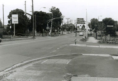 Whitehorse Historical Society Inc.
Photograph, Mitcham & Brunswick Roads, 2000
... Railway Crossing. From left-right: Rail Station sign - 'Mitcham... and Brunswick Road, Mitcham, looking North towards Railway Crossing ...Produced as one of a series of 24 prints commissioned by Nunawading & District Historical Society -|Theme: Intersections of Mitcham and Nunawading 2000/2001.|See also Series by P. Simmenauer on the same theme.Black and white photograph - print and negative of Corner of Mitcham Road and Brunswick Road, Mitcham, looking North towards Railway Crossing. From left-right: Rail Station sign - 'Mitcham/Station/Connex'. On near side corner of Brunswick Road signage for: Mitcham Angling Club; Mitcham Community Centre; Mitcham Senior Citizens Club; Street sign: Brunswick Road.mitcham railway station, connex, mitcham angling club, angler's club, mitcham community house, mitcham senior citizens club, brunswick road, mitcham, mitcham road