Showing 273 items
matching railway platform
-
 Eltham District Historical Society Inc
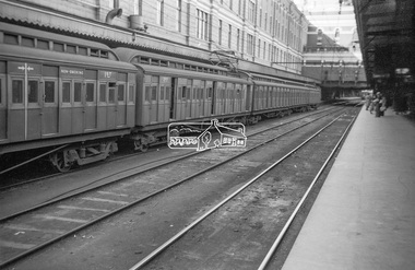
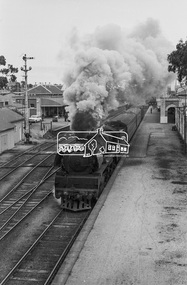
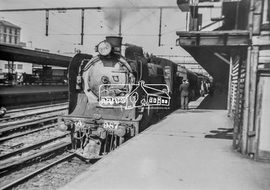
Photograph, George Coop, View of Tait Red Rattler at No. 1 Platform, Flinders Street Railway Station, Sep. 1954
... View of Tait Red Rattler at No. 1 Platform, Flinders Street... Platform, Flinders Street Railway Station Photograph Photograph ...Most likjely taken either arriving or departing from a visit of the display at Spencer Street Railway Station during the 1954 Victorian Railways Centenary Exhibition, 11-25 Sep. 1954 "V.R. Cavalcade" Centenary 1854-1954 Exhibition (11-25 Sep 1954) presented a model railway occupying about 1,400 square feet in the Lower Town Hall featuring a number of model railway working scale models. The exhibition also included a display of rolling stock, track, electrical and other railway equipment held at Spencer Street Railway Station.Digital TIFF file Scan of Kopdak 620 black and white negative transparencygeorge coop collection, v.r. cavalcade, victorian railways centenary 1854-1954 exhibition, red rattler, tait train -
 Eltham District Historical Society Inc
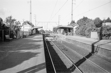
Photograph, George Coop, Mont Albert Railway Station, c.1956
Churchill Street shops just visible on right of image. The grass embankment visible in the distance on the left of the track is from where another view looking down the track beside Churchill Street was taken. Shows the original building on the northern platform of the Mont Albert station. The railway line was extended out to Lilydale with work commencing in 1882. Mont Albert station opened in 1890. It is presumed that this building was demolished when the third line was constructed in 1971. At the same time the nearby Surrey Hills original station buildings were demolished. George noted that he had donated a black and white print copy of this image some years earlier to the Surrey Hills Historical Society - see SHP2018/21/6 https://victoriancollections.net.au/items/5d6a450a21ea670e188d05c9Digital TIFF file Scan of Kopdak 620 black and white negative transparencygeorge coop collection, churchill street, mont albert railway station -
 Eltham District Historical Society Inc
Photograph, Tess Justine (Nillumbik Shire Council), Murray's Bridge over the Diamond Creek, Eltham North, 19 Feb 2022
Murray's Bridge over the Diamond Creek on the Diamond Creek Trail just prior to demolition and replacement with a new steel bridge. Heritage advice obtained by Nillumbik Shire Council, following a suggestion by the Eltham District Historical Society (EDHS), is that the original bridge appears to have been a simplified version of the Country Roads Board’s (CRB) standard timber bridge design of the early-to-mid 1920s. In c1990 Murray’s bridge was renovated with three recycled steel girders as part of a bike/pedestrian path in the reserve. During these alterations many parts of the bridge were removed, and some were replaced. Heritage advice indicates the condition of Murray’s bridge is poor. The remaining original parts are all in poor condition, with severe weathering, splitting and rot, especially to the stringers retained on the bridge. Heritage advice is that Murray’s Bridge does not have sufficient significance in the cultural history of the Nillumbik area to warrant inclusion in the Nillumbik Shire Heritage Overlay and also does not have sufficient significance as a rare survivor to warrant inclusion in the Nillumbik Shire Heritage Overlay. There are no indications in the historical record that this site was individually important to the cultural history of this area. EDHS is comfortable with the heritage advice provided to Council and has worked closely on this project with Council. EDHS has suggested some of the removed timbers be used in the vicinity of the bridge for landscaping and possibly seating, so as to retain these remnants close to the site of the original bridge, which is the last old timber bridge along the lower reaches of the Diamond Creek. Mary (Sweeney) Murray and John Wright Murray selected 80 acres, Lot C Section 16 and Lot 5 Section 17 Parish of Nillumbik, under an occupation license in 1866. John died in 1867 and freehold was granted to his son John in 1873. The farm was known as ‘Laurel Hill’. John Junior was an Eltham Shire councillor and sometime president from 1887 up until 1897. He added Lot A Section 16 to the farm in ca1888. John and his younger brother James arranged to rent/purchase Lot B Section 17, across Diamond Creek to the west, in ca1900. It appears that John and James farmed separately for a few years, with a new homestead built for James ad family on the high point of Lot B Section 17 in ca1910. John sold off Lot 5 Section 17 in 1912. When John died in 1912 James took over the land on both sides of the Diamond Creek. The old homestead on the west side of the Creek disappeared. A farm bridge over Diamond Creek from this period may have been located close to the northern boundary of the farm. John Langlands, owner of the farm known as ‘Ihurst’ on the west side of Diamond Creek to the south of the Murray’s land, died in 1907. In 1909 his land was then subdivided into 100 lots to become the ‘Glen Park Estate’. Other similar subdivisions of nineteenth century farms around Eltham in this period included the ‘Franktonia (or Beard’s) Estate’ to the northeast and ‘Bonsack’s Estate’ between Eltham and Greensborough. Soon after the opening of the railway extension line from Eltham to Hurstbridge in 1912, Glen Park and nearby residents including James Murray agitated for a railway station or siding to be located half-way between Eltham and Hurstbridge, so that the Glen Park residents who used the railway daily did not have to walk into the Eltham or Hurstbridge stations. Some believed Coleman’s Corner (opposite Edendale Farm) was an appropriate spot for the platform. James Murray was among those who thought the railway should be located on his land, closer to half-way between Eltham and Hurstbridge stations. The Railways Commissioners warned that the locals would have to fund these works themselves. The Glen Park Estate residents initially had difficulty accessing Eltham by road, with only an old low-level bridge over Diamond Creek at the south end of their estate. A new timber trestle bridge across the creek, now on Wattletree Road, was opened in 1915. Road access to the north was gained in 1927 when the new Murray’s Road, which crossed the Murray’s land, was built. Residents continued to agitate for a Glen Park station. By 1926 the Railways Commissioners’ preferred site was on the Murray’s land. They arranged an estimate of cost of a full-length platform. The estimate was too much for the locals, who in 1928 argued unsuccessfully for a shorter and hence cheaper platform. By 1929 Murray had agreed to donate the land, but the locals would still have to fund the works. Murray decided, unilaterally it would appear, to commence work on a timber trestle road bridge over Diamond Creek to link the new Murray Road to the proposed station. Late in 1929 he stopped work on the bridge, for reasons unknown, but started work again and completed the bridge in 1931. There is no further newspaper evidence of the campaign for the Glen Park station until 1939, when Murray and another local, Mr Maxwell, met the Railways Commissioner. The Glen Park locale now included 45 homes on the west side of the creek and 20 on the Eltham side. Most of the residents used the train every day. The Commissioner remained adamant that only a full-length platform could be built for safety reasons. It appears the campaign dissolved at this point. The increasing move to cars may have had an impact. There is no evidence of Murray’s bridge ever being connected to Murray’s Road, or of it having wide use for any purpose by locals. James Murray died in 1947 and the farm was taken over by his son James (Jim). Jim started to sell off parts of the farm in the 1980s, retaining a few acres around the ca1910 homestead and building a new house there. Recreation reserves were established along the creek. In ca1990 Murray’s bridge was renovated with steel girders as part of a bike/pedestrian path in the reserve. The old farmhouse was demolished in ca2014. * * * A theory posted on local community Facebook groups was that the bridge was built in the 1860s and was built to be more robust than was necessary for the movement of cows from one side of the creek to the other. It was suggested the robustness was necessary to support the weight of gold ore being transferred from a mine on Murray’s land to a railway siding near Murrays Bridge (presumably for transfer and processing at Diamond Creek). Perhaps this may have been one of the motivators for Murray, who really knows? Knowing when mining operations ceased on his land and how that fits the overall timeline would be useful but at the time the bridge was built, local gold production was minimal at best. The known facts are: • The railway line came to Eltham in 1902. • The extension of the railway from Eltham to Hurstbridge was constructed in 1912 so no railway line even existed through Murray's property until 1912 and the Victorian Railways maps at the time show no such siding on Murray’s property. • In 1923 a new company was formed in anticipation of the old Diamond Creek Gold Mine being re-opened. The mine had been previously closed and flooded. It was noted in the press at the time that the mine was within a mile of the railway. Nothing really came of this. • Construction of Murrays Bridge was commenced by James Murray in early 1929 in anticipation of a proposed flag station being nominated on his land, but work ceased shortly afterwards. The proposed flag station was commonly referred to as Glen Park as the residents of the Glen Park Estate wanted Option 1, located near them with the platform adjacent to Colemans corner. This was probably never going to fly as it was virtually in eyesight of Eltham station. Allandale Road was the third option, but the Commissioners' preferred option was No. 2 - on Murray's property. • The Railway Commissioners were not going to finance any such station and the works had to be funded by private landowners and residents, hence Murray investing in this himself. • Murray recommenced work two years later and finished his bridge in 1931 but unfortunately for him, the proposed flag station never eventuated. The bluestone siding you reference may well have been built by Murray as part of the proposed station platform. • Up until then, apart from the Main Road bridge, which was washed away in 1924, virtually all local crossings over the Diamond Creek were low lying bridges – Kaylocks Bridge at Brougham Street, Diamond Street bridge, Glen Park Road bridge. It is expected that Murray also had a low-lying bridge to connect his land either side of the creek. These were all washed away or severely damaged multiple times in the 1920s. Lessons were learnt, and Murrays Bridge appears to have been built in accordance with Country Road Board standards of the time. Flood damage was ongoing, and even more recently constructed raised bridges kept getting washed away, e.g., the new Wattle Tree Road bridge in 1958 just months after completion. Murray’s bridge was reinforced with steel some 30 years ago presumably to provide additional floodwater resistance, given the history of bridges disappearing in floodwaters. • In March 1932 it was reported in the Advertiser that there were still some prospectors operating around Eltham North who apart from further scarring the face of the earth over the previous two years had gained significant experience but little gold - hardly a driving factor for constructing a dedicated railway siding and bridge to transfer gold ore. It is far more probable that James Murray was hoping to have the railway station located on his property and invested his money by building the bridge to lead to it as well as a station platform. Had the station eventuated, it may well have driven up the value of his land for subdivision and new housing estates like the Glen Park Estate. That did not eventuate. Whilst the bridge was indeed old (90 years), the core structure being completed in 1931, it had been modified substantially from original and hence had no significant historic value – i.e., it was not a representative example of its type, construction, and age. Given that the bridge was not worthy of saving, the Eltham District Historical Society with Council’s support, and the Eltham Woodworkers group endeavoured to see what suitable sized timbers were salvageable to fabricate a commemorative seat. Unfortunately, the experts at the Woodworkers group were unable to salvage any suitable length/width timbers to fabricate the seat due to the presence of rot. Last remaining wooden trestle bridge on the Diamond Creek Trail just prior to demolition and replacementBorn digital image (27)diamond creek (creek), diamond creek trail, murrays bridge, ‘laurel hill’, john wright murray, mary (sweeney) murra, john murray jnr, james murray, john langlands, ‘ihurst’, ‘glen park estate’, beard's estate, franktonia, bonsack's estate, glen park estate, glen park railway station -
 Eltham District Historical Society Inc
Photograph, Tess Justine (Nillumbik Shire Council), Construction work on replacement of Murray's Bridge over the Diamond Creek, Eltham North, 31 Mar 2022
Construction work on replacement of Murray's Bridge over the Diamond Creek on the Diamond Creek Trail Mary (Sweeney) Murray and John Wright Murray selected 80 acres, Lot C Section 16 and Lot 5 Section 17 Parish of Nillumbik, under an occupation license in 1866. John died in 1867 and freehold was granted to his son John in 1873. The farm was known as ‘Laurel Hill’. John Junior was an Eltham Shire councillor and sometime president from 1887 up until 1897. He added Lot A Section 16 to the farm in ca1888. John and his younger brother James arranged to rent/purchase Lot B Section 17, across Diamond Creek to the west, in ca1900. It appears that John and James farmed separately for a few years, with a new homestead built for James ad family on the high point of Lot B Section 17 in ca1910. John sold off Lot 5 Section 17 in 1912. When John died in 1912 James took over the land on both sides of the Diamond Creek. The old homestead on the west side of the Creek disappeared. A farm bridge over Diamond Creek from this period may have been located close to the northern boundary of the farm. John Langlands, owner of the farm known as ‘Ihurst’ on the west side of Diamond Creek to the south of the Murray’s land, died in 1907. In 1909 his land was then subdivided into 100 lots to become the ‘Glen Park Estate’. Other similar subdivisions of nineteenth century farms around Eltham in this period included the ‘Franktonia (or Beard’s) Estate’ to the northeast and ‘Bonsack’s Estate’ between Eltham and Greensborough. Soon after the opening of the railway extension line from Eltham to Hurstbridge in 1912, Glen Park and nearby residents including James Murray agitated for a railway station or siding to be located half-way between Eltham and Hurstbridge, so that the Glen Park residents who used the railway daily did not have to walk into the Eltham or Hurstbridge stations. Some believed Coleman’s Corner (opposite Edendale Farm) was an appropriate spot for the platform. James Murray was among those who thought the railway should be located on his land, closer to half-way between Eltham and Hurstbridge stations. The Railways Commissioners warned that the locals would have to fund these works themselves. The Glen Park Estate residents initially had difficulty accessing Eltham by road, with only an old low-level bridge over Diamond Creek at the south end of their estate. A new timber trestle bridge across the creek, now on Wattletree Road, was opened in 1915. Road access to the north was gained in 1927 when the new Murray’s Road, which crossed the Murray’s land, was built. Residents continued to agitate for a Glen Park station. By 1926 the Railways Commissioners’ preferred site was on the Murray’s land. They arranged an estimate of cost of a full-length platform. The estimate was too much for the locals, who in 1928 argued unsuccessfully for a shorter and hence cheaper platform. By 1929 Murray had agreed to donate the land, but the locals would still have to fund the works. Murray decided, unilaterally it would appear, to commence work on a timber trestle road bridge over Diamond Creek to link the new Murray Road to the proposed station. Late in 1929 he stopped work on the bridge, for reasons unknown, but started work again and completed the bridge in 1931. There is no further newspaper evidence of the campaign for the Glen Park station until 1939, when Murray and another local, Mr Maxwell, met the Railways Commissioner. The Glen Park locale now included 45 homes on the west side of the creek and 20 on the Eltham side. Most of the residents used the train every day. The Commissioner remained adamant that only a full-length platform could be built for safety reasons. It appears the campaign dissolved at this point. The increasing move to cars may have had an impact. There is no evidence of Murray’s bridge ever being connected to Murray’s Road, or of it having wide use for any purpose by locals. James Murray died in 1947 and the farm was taken over by his son James (Jim). Jim started to sell off parts of the farm in the 1980s, retaining a few acres around the ca1910 homestead and building a new house there. Recreation reserves were established along the creek. In ca1990 Murray’s bridge was renovated with steel girders as part of a bike/pedestrian path in the reserve. The old farmhouse was demolished in ca2014. Born digital image (5)diamond creek (creek), diamond creek trail, murrays bridge, ‘laurel hill’, john wright murray, mary (sweeney) murra, john murray jnr, james murray, john langlands, ‘ihurst’, ‘glen park estate’, beard's estate, franktonia, bonsack's estate, glen park estate, glen park railway station -
 Eltham District Historical Society Inc
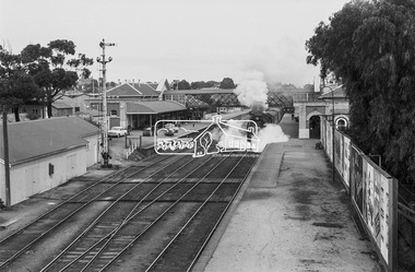
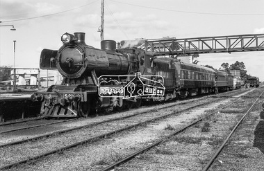
Photograph, Steam locomotive R-704 at Bendigo Railway Station, c.November 1962, 1962
Note the EJ Holden on the station platform with trailer attached. EJ Holden Production Sedan & Station Sedan: July 1962–August 1963Digital TIFF file Scan of 35mm Ilford FP3 black and white negative transparencybendigo, bendigo railway station, george coop collection, holden ej, r-704, r-class steam locomotive -
 Eltham District Historical Society Inc
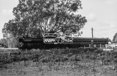
Photograph, Steam locomotive R-704 departing from Bendigo Railway Station, c.November 1962, 1962
Note the EJ Holden on the station platform with trailer attached. EJ Holden Production Sedan & Station Sedan: July 1962–August 1963Digital TIFF file Scan of 35mm Ilford FP3 black and white negative transparencybendigo, bendigo railway station, george coop collection, holden ej, r-704, r-class steam locomotive -
 Eltham District Historical Society Inc
Photograph, Steam locomotive R-704 departing from Bendigo Railway Station, c November 1962
R704 departs Bendigo Station with what was probably the Swan Hill passenger service. Note the EJ Holden on the station platform with trailer attached. EJ Holden Production Sedan & Station Sedan: July 1962–August 1963Digital TIFF file Scan of 35mm Ilford FP3 black and white negative transparencybendigo, bendigo railway station, george coop collection, holden ej, r-704, r-class steam locomotive -
 Eltham District Historical Society Inc
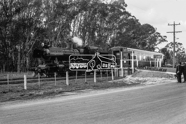
Photograph, Steam locomotive J-521 with the Royal Train at Echuca Railway Station during a visit by the new Governor of Victoria, His Excellency Sir Rohan Delacombe, c.May 1963
In this picture can be seen steam locomotive J-521 and tender to which is attached State Car No. 5. It is believed that the other support carriages have been de-attached and the train has pulled up at the front of the platform allowing room for other trains to pull in. Immediately behind on the same track at the platform is a Diesel Electric Rail Motor (DERM) and C-class bogey (luggage) then a small (articulated) rail car (articulated) then a cattle van. On the adjacent track is State Car No. 2 (Melville) and a C-van. State Car No. 2 (Melville) was used a power generation car for special trains and the Train of Knowledge. State Car No. 5 is in the design of the Spirit of Progress. George Coop advised that the occasion is the visit of the Governor of Victoria, Sir Rohan Delacombe to Echuca in 1963. Delacombe had replaced Sir Dallas Brooks in May 1963 who had departed for England on the liner Iberia,11 April 1963 (1963 'SIR DALLAS ON WAY TO U.K.', The Canberra Times (ACT : 1926 - 1995), 9 April, p. 9. , viewed 27 Jan 2020, http://nla.gov.au/nla.news-article104249252) George believes the Governor was doing a considerable formal train ride around the State and Echuca was on the schedule. The ‘platform’ was a special creation for such purposes, located on the wharf spur line that ran behind the Echuca Civic Centre. The large notice board commemorates the Queen’s visit on March 5th, 1954 for which the platform was initially built. From time to time it would get spruced up with pot plants, fresh paint and repaired hand rails for formal functions. George attended the Civic Reception held for the Governor. A picture of His Excellency Sir Rohan Delacombe, Governor of Victoria, and Lady Delacombe about to entrain at Spencer Street for a visit to western Victoria is available on page 4 of VICTORIAN RAILWAYS REPORT OF THE VICTORIAN RAILWAYS COMMISSIONERS FOR THE YEAR ENDED 30th JUNE, 1963. (http://www.victorianrailways.net/vr%20history/annual_reports/vrar1963.pdf) More information about the Victorian Railways Royal Train https://en.wikipedia.org/wiki/Victorian_Railways_Royal_Train State Car No. 5 https://www.pjv101.net/cd/pages/c160v06.htm State Car No. 2 (Melville) https://www.pjv101.net/cd/pages/c160v03.htmDigital TIFF file Scan of 35mm Ilford FP3 black and white negative transparencycattle van, c-van, diesel electric rail motor (derm), echuca, echuca rail yard, echuca railway station, george coop collection, governor of victoria, j-521, rail car, royal train, power car, sir rohan delacombe, state car no. 2 (melville), state car no. 5, train of knowledge, victorian railways -
 Eltham District Historical Society Inc
Photograph, Steam locomotive J-521 with the Royal Train on the Wharf Spur line during a visit to Echuca by the new Governor of Victoria, His Excellency Sir Rohan Delacombe, c.May 1963
In this picture The Royal Train is passing through a railway crossing along the Wharf Spur line. The train has been shortened comprising steam locomotive J-521 and tender to which is attached the State car. The State car is in the design of the Spirit of Progress. George Coop advised that the occasion is the visit of the Governor of Victoria, Sir Rohan Delacombe to Echuca in 1963. Delacombe had replaced Sir Dallas Brooks in May 1963 who had departed for England on the liner Iberia,11 April 1963 (1963 'SIR DALLAS ON WAY TO U.K.', The Canberra Times (ACT : 1926 - 1995), 9 April, p. 9. , viewed 27 Jan 2020, http://nla.gov.au/nla.news-article104249252) George believes the Governor was doing a considerable formal train ride around the State and Echuca was on the schedule. The ‘platform’ was a special creation for such purposes, located on the wharf spur line that ran behind the Echuca Civic Centre. The large notice board commemorates the Queen’s visit on March 5th, 1954 for which the platform was initially built. From time to time it would get spruced up with pot plants, fresh paint and repaired hand rails for formal functions. George attended the Civic Reception held for the Governor. A picture of His Excellency Sir Rohan Delacombe, Governor of Victoria, and Lady Delacombe about to entrain at Spencer Street for a visit to western Victoria is available on page 4 of VICTORIAN RAILWAYS REPORT OF THE VICTORIAN RAILWAYS COMMISSIONERS FOR THE YEAR ENDED 30th JUNE, 1963. (http://www.victorianrailways.net/vr%20history/annual_reports/vrar1963.pdf) More information about the Victorian Railways Royal Train https://en.wikipedia.org/wiki/Victorian_Railways_Royal_Train State Car No. 5 https://www.pjv101.net/cd/pages/c160v06.htm Digital TIFF file Scan of 35mm Ilford FP3 black and white negative transparencyechuca, george coop collection, governor of victoria, j-521, railway crossing, royal train, sir rohan delacombe, state car no. 5, victorian railways, wharf spur line -
 Eltham District Historical Society Inc
Photograph, Steam locomotive J-521 with the Royal Train on the Wharf Spur line during a visit to Echuca by the new Governor of Victoria, His Excellency Sir Rohan Delacombe, c.May 1963
In this picture the Royal Train is pulled up with the State Car at the commemorative platform on the Wharf Spur line. The train has been shortened comprising steam locomotive J-521 and tender to which is attached the State car. The State car is in the design of the Spirit of Progress. The platform is lined with plants in planter boxes. Two men in suits standing to the right, one with a large camera – either press or official photographer. The sign on the platform commemortaes the visit of Her Majesty Queen Elizabeth and His Royal Highness Phillip Duke of Edinburg on March 5th, 1954. George Coop advised that the occasion is the visit of the Governor of Victoria, Sir Rohan Delacombe to Echuca in 1963. Delacombe had replaced Sir Dallas Brooks in May 1963 who had departed for England on the liner Iberia,11 April 1963 (1963 'SIR DALLAS ON WAY TO U.K.', The Canberra Times (ACT : 1926 - 1995), 9 April, p. 9. , viewed 27 Jan 2020, http://nla.gov.au/nla.news-article104249252) George believes the Governor was doing a considerable formal train ride around the State and Echuca was on the schedule. The ‘platform’ was a special creation for such purposes, located on the wharf spur line that ran behind the Echuca Civic Centre. The large notice board commemorates the Queen’s visit on March 5th, 1954 for which the platform was initially built. From time to time it would get spruced up with pot plants, fresh paint and repaired hand rails for formal functions. A picture of His Excellency Sir Rohan Delacombe, Governor of Victoria, and Lady Delacombe about to entrain at Spencer Street for a visit to western Victoria is available on page 4 of VICTORIAN RAILWAYS REPORT OF THE VICTORIAN RAILWAYS COMMISSIONERS FOR THE YEAR ENDED 30th JUNE, 1963. (http://www.victorianrailways.net/vr%20history/annual_reports/vrar1963.pdf) More information about the Victorian Railways Royal Train https://en.wikipedia.org/wiki/Victorian_Railways_Royal_Train State Car No. 5 https://www.pjv101.net/cd/pages/c160v06.htmDigital TIFF file Scan of 35mm Ilford FP3 black and white negative transparencyechuca, george coop collection, governor of victoria, j-521, royal train, sir rohan delacombe, state car no. 5, victorian railways, wharf spur line -
 Eltham District Historical Society Inc
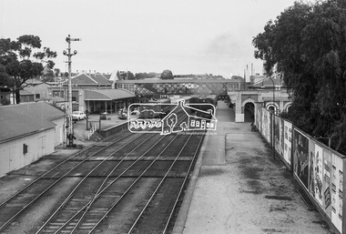
Photograph, George Coop, A2-class Steam Locomotive 987 at Spencer Street Railway Station, c. November 1962, 1962
... of the platform at Spencer Street Railway Station.... of the platform at Spencer Street Railway Station. A2 Class Steam ...Current Southern Cross Railway Station was originally Spencer Street Railway Station prior to upgrade and addition of wave form roof This photo was taken the same time as EDHS_05399 Diesel-electric rail cars in the Railmotor Yard on the other side of the platform at Spencer Street Railway Station.Digital TIFF file Scan of 35mm Ilford FP3 black and white transparencya2 class steam locomotive, a2-987, george coop collection, southern cross railway station, spencer street railway station -
 Wycheproof & District Historical Society Inc.
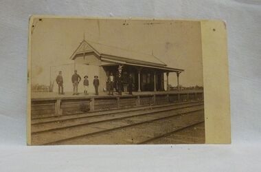
Sepia photo, Photographer unknown, Historic Wycheproof Railway Station, 1904 (estimated)
This railway station building was erected in 1887 and closed in 1990. Now a new chapter begins with a newly restored station building amd platform that re-opened in October 2010 to be used by the Wycheproof Community.The Wycheproof Railway station constructed by Hossack & Brown in 1887 is Heritage listed and is on the Government Buildings Register. This photo is one of only a few available of the early days of the Station.The complex is historically significant at a State level AHC A.4. The Railway station contains significant detailing such as in the turned timber posts and overall composition. This early photo of Wycheproof railway station, shows a construction of timber with corrugated iron clad roof,in c.1904. Features of the design are the timber verandah posts with decorative elements which include chamfers and supporting diagonal timber brackets. The gabled roof has finials on the east and west ends. Seven people pose on the platform,the staff in uniform of the times.Nilregister, , railways, wycheproof, historic buildings, 1900s -
 Greensborough Historical Society
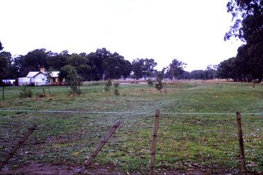
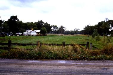
Slide - Photograph, John Ramsdale, Rail line near Whittlesea: Slide 120, 1990s
Photograph shows what appears to be a rural farmhouse and paddock, this is part of the site of the old railway line to Whittlesea. In centre of photo is the old station platform.Part of the John Ramsdale collection of slides and audio visual material.Colour photograph scanned from slide.No maker's marks. No caption on slide.whittlesea, whittlesea rail line -
 Greensborough Historical Society
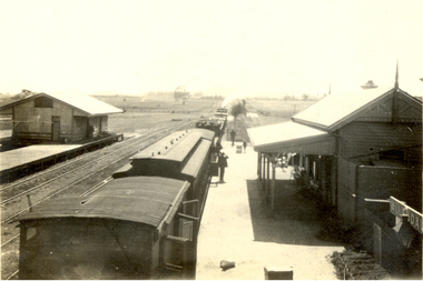
Photograph - Photograph - Digital Image, A. E. Smith, Greensborough Station 1967, 1967
... A stationary Tait train along a curved platform... a curved platform at Greensborough railway station (1967 ...A stationary Tait train along a curved platform at Greensborough railway station (1967) with the station building on the right. Photographer: Smith, A. E. Source: State Library Victoria. This photograph shows Greensborough Station before it was remodelled to a central "island" platform.Colour digital photograph.greensborough station -
 Greensborough Historical Society
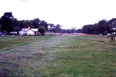
Slide - Photograph, John Ramsdale, Rail line near Whittlesea: Slide 94, 1990s
Photograph shows what appears to be a rural farmhouse and paddock, this is part of the site of the old railway line to Whittlesea. In centre of photo is the old station platform.Part of the John Ramsdale collection of slides and audio visual material.Colour photograph scanned from slide.No maker's marks. No caption on slide.whittlesea, whittlesea rail line -
 Greensborough Historical Society
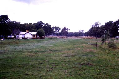
Slide - Photograph, John Ramsdale, Old Whittlesea rail line: Slide 107, 1990s
Photograph shows what appears to be a rural farmhouse and paddock, this is part of the site of the old railway line to Whittlesea. In centre of photo is the old station platform.Part of the John Ramsdale collection of slides and audio visual material.Colour photograph scanned from slide.No maker's marks. No caption on slide.whittlesea, whittlesea rail line -
 Greensborough Historical Society
Slide - Photograph, John Ramsdale, Old railway line Whittlesea: Slide 47, 1990s
Photograph shows what appears to be a rural farmhouse and paddock, this is part of the site of the old railway line to Whittlesea. In centre of photo is the old station platform.Part of the John Ramsdale collection of slides and audio visual material.Colour photograph scanned from slide.No maker's marks. No caption on slide.whittlesea, whittlesea rail line -
 Greensborough Historical Society
Photograph - Digital Image, Upgrades to Greensborough Station 1970, 1970_
Photograph of construction of the new station at Greensborough. The existing track can be seen plus construction of a second track, making the station an island platform. The new station was opened on 03/04/1970.Digital copy of black and white photograph. trains, greensborough railway station -
![Photograph - Digital image, Greensborough Railway Station [2], 1930-1940](/media/collectors/4f729f5697f83e03086015b8/items/54435c822162f10ea4a1fd2b/item-media/54435ca72162f10ea4a1fe4b/item-fit-380x285.jpg) Greensborough Historical Society
Greensborough Historical SocietyPhotograph - Digital image, Greensborough Railway Station [2], 1930-1940
Photograph of Greensborough Railway Station, early 20th century, showing train and group of young people on platform. A car parked outside the Roy House on Main Street Greensborough [opposite the future entrance to the Greensborough Plaza] This photo is from the Lorraine Coates Collection.An early photograph of Greensborough Station.Digital copy of black and white photograph.greensborough station -
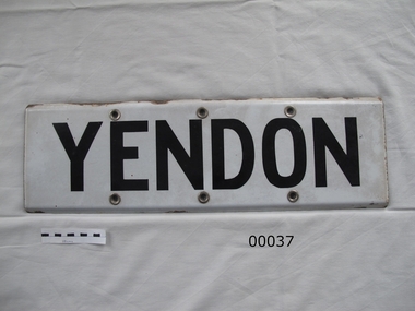 Yendon History Group
Enamel Station Sign
The sign is shown in photo P , taken on the western platform in 1967. Just prior to demolition of the station, the sign was taken by Ian Smith of Buninyong, and kept by him until its donation to the YHG.Sign from Yendon station platform. Metal, black underneath, front white with black lettering. Top and bottom edges rolled over to the back. Three holes along the top and bottom edges, fitted with metal eyelets.YENDONyendon railway station, station sign -
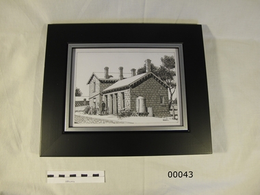 Yendon History Group
Framed pen and ink sketch of Yendon station, Mervyn Hill, 2010
Sketch was done as a sample of the artist's work when a drawing was sought to be the picture of the station on the interpretive sign planted at Yendon station. Although this is an excellent interpretation of the station building, it was thought to be too detailed for the purpose.Pen and ink detailed drawing of Yendon station building, with 2 people standing on the platform. Frame is timber, 50mm wide, mat black, with an 8mm silver trim around the cut-out hole.Signed by Mervyn Hill at the bottom right hand corner.yendon railway station, hill, mervyn, ink drawing -
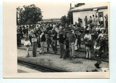 Orbost & District Historical Society
black and white photograph, second half 20th century
This appears to be a photograph of a large group of people at the Orbost Railway Station awaiting a train - a steam train? The group seems to be made up of family groups. This item is associated with the history of the Orbost-Bairnsdale railway line and therefore reflects the role that the rail line played in the social and economic history of Orbost. The closure of the line was a significant event in Orbost's history. It is a pictorial record of a social event in Orbost.A black / white photograph of a large group of people standing at a railway station. Some are standing on the platform, others on the line. Most are looking toward the right.orbost-railway-station family-activity -
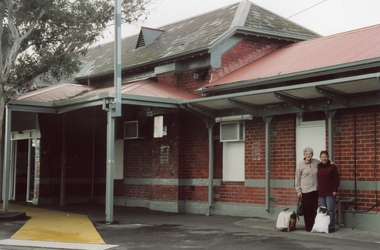 Ringwood and District Historical Society
Photographs, Ringwood Railway Station buildings circa 2000
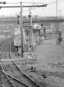
Collection of three Ringwood photographs:; 1. Ringwood Station (No 1 Platform); 2. Ringwood Station (No 2 Platform); 3. Ringwood signal box -
 Ringwood and District Historical Society
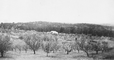
Photograph, Herman Pump's orchard looking towards Heathmont Railway Station 1927. Station and platform on left
Typed below photograph, "Herman Pump's orchard looking towards Heathmont Railway Station 1927. Station and platform on left". -
 Orbost & District Historical Society
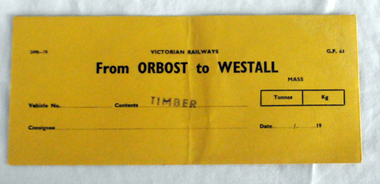
railways envelope, C 1980's
This item was used by Victorian Railways 1970's/1980's. It was used at Orbost Railway Station for the consignment of timber from Orbost to Westall.. Westall was a major timber-receiving depot near Dandenong, Victoria. Westall railway station is located on the Pakenham and Cranbourne lines in Victoria, Australia. It serves the south-eastern Melbourne suburb of Clayton South, opening on 6 February 1951. Westall station was opened as a workers only platform on 16 October 1954. It was provided for the adjacent Martin & King railway coachbuilding factory. The station was opened to the public on 1 June 1959 when all trains on the line began stopping there. The Bairnsdale-Orbost railway was opened in 1916 to serve the agricultural and timber industry. Because of the decline in traffic and heavy operating costs, the line was finally closed in August, 1987. Orbost Railway Station was opened on Monday 10 April 1916 as the terminus of the Orbost railway line, and closed in 1987. The station was located on the west side of the Snowy River despite the town of Orbost being on the east side of the river, in order to save on the costs of a bridge over the river, which at the time had highly variable levels. This item is associated with the history of the Orbost-Bairnsdale railway line and therefore reflects the role that the rail line played in the social and economic history of Orbost.An unused brown/buff coloured goods/freight consignment envelope used by Victorian Railways, this one for timber from Orbost to Westall. It is DL size.2497-78 VICTORIAN RAILWAYS G.F 63 From ORBOST to WESTALL MASS Tonnes kg Vehicle No Contents TIMBER Consignee Date orbost-bairnsdale-railway westall -
 Eltham District Historical Society Inc
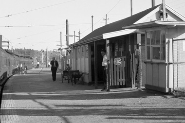
Photograph, Fred Mitchell, Steam locomotive K-190 with excursion train at Eltham Railway Station, 1970, 1970
The engine is running around its carriages waiting at the platform. A Harris and two Hitachi trains are In the sidings.Digital copy of colour photographfred mitchell collection, k-190, steam engine, 1970, eltham, eltham railway station -
 Glen Eira Historical Society
Article - Rosstown Railway
... Koornang Road Poath Road Warragul Road Railway Platforms Railway ...This file contains three items: 1/A review of the ROSSTOWN RAIL TRAIL from LIVING IN GLEN EIRA, vol. 11, 2004, Issue 4, no. 25, date and author unknown. The review explains the purpose of the Rail Trail with a brief narrative of the history behind Rosstown Sugar Mill Railway line. Concluding with information on the location of the Trail and the expected time required to walk the entire track included in the review is a map of the Rail Trail, which marks significant sites along the trail with historic pictures. 2/A newspaper article from THE AGE, dated Tuesday 21/10/1980 and written by Iola Matthews, reporting on the circumstances that led to the publication of the book RETURN TO ROSSTOWN written by Des Jowett and Ian Weickhardt. The article begins with a brief biography of the authors before moving into details of the book’s content, providing a further biography of W. Murray Ross which includes information on his financial ventures – particularly the Rosstown Rail – his marriage and children. The article includes a black and white photograph of Weickhardt and Jowett walking along the route of the railway line, an illustration of the Rosstown sugar works and a map of the area surrounding the site of the mill. 3/Three photocopies of a black and white illustration of the Rosstown sugar works from the east, undated and artist unknown.rosstown rail trail, rosstown, ross william, ross w. murray, ross murray, sugar beet mills, mills, elsternwick, land transport, railways, railway lines, railway routes, carnegie neville street, carnegie miller street, factories, market gardens, horticulture, peat, soils, land forms, topography, geology, civic issues, cone sugar industry, elsternwick plaza, elsternwick, glenhuntly road, parks and reserves, ee gunn reserve, caulfield racecourse, sportsgrounds, caulfield, carnegie, riddell parade, clarence street, aileen avenue, princes park, dover street, marara road, oakleigh road, rosanna street, murrumbeena crescent, north road, kooyong road, hawthorn road, booran road, koornang road, poath road, warragul road, railway platforms, railway buildings, bambra road, swamps, landforms, landfill, council landfill, railway bridges, bridges, railway underpasses, sporting clubs, tennis clubs, bowls clubs, rosstown railway, rosanna street reserve, maps, railway maps, living in glen eira, weickhardt ian, jowett des, caulfield south, curraweena road, oakleigh, caulfield technical school, return to rosstown, beet sugar industry, crops, land booms, land development and subdivisions, bent thomas, fink benjamin, sugar works, rosstown hotel, oamdenong road, rosstown dry cleaners, shops, rosstown road, rosstown plate, people by circumstance, migrants, accountants, occupations, professionals, the grange, real estate, grange road, financial agents, judges, rosstown estate, financial trouble, rabbit preserving, breweries, political debates, political issues, political electorates, politics, political science, debt, financial loans, court procedures, court cases, legal events and activities, malleson and riggall, widowers, seabeach railway, economics, economic deadline, depression 1890s, economic crash, mortgages, divorce, social problems, poverty, ross claude, ross roderick, world war 1914-1918, wars, military history, servicemen, australian flying corps, engineers, caulfield council, swagmen, homelessness, glenhuntly road, glenhuntly road tram, woornack road, leila road, wild cherry road, melten avenue, illustrations, steam trains, trains, horse and cart, horse-drawn transport, railway stations -
 Federation University Historical Collection
Photograph, Noel L. Harvey, Yendon Railway Station, 1968, 03/12/1968
Buninyong had no railway station so residents would travel to Yendon to catch the train. The Yendon Railway Station building was demolished soon after this photograph was taken. The bluestone was purchased by John Vernon, and was used to construct retaining walls in a garden enclosure between the first two buildings at the new Ballarat Institute of Advanced Education campus at Mt Helen. This is now known as the courtyard between building 'F' and building 'G' at the University of Ballarat mt Helen Campus. The following article was published in the Ballarat Courier on 06 December 1968. 'Yendon Station to be demolished - The old bluestone railway station at Yendon is to be demolished. C.A.D. Fisken told Buninyong Shire Council of the proposal at its meeting yesterday. Fortunately, he said, the beautiful stonework would not be lost. It would be used and incorporated in the new School of Mines building at Mt Helen. the retention of the century-old building was the subject of representations by Council to the Railways following the closure of the station for goods traffic 'some time ago'. The building had also been noted by the National Trust as one of special interest. The Railways Department advised the meeting that an inspection had been made at the Yendon level crossing, but no recommendation could be made at present for installation of flashing light signals.'Bluestone building with dressed bluestone door and window jambs and chimney. The roof is corrugated iron. The platform edge is also of bluestone construction. The building is the former Yendon Railway Station (now demolished) on the Ballarat -Geelong main line (the original Melbourne to Ballarat mainline). When the line was opened, this station may have been originally called Buninyong as it was built a number of years before the Ballarat to Buninyong branch line was built. This this has subsequently caused some confusion. The station was later renamed Yendon. Verso in blue ballpoint pen 'No 47 Yendon Railway Stn' Stamped in purple ink 'N.L. Harvey & Son, Photographers, 131 Sturt Streeet Ballarat, Phone 25766, After hours 23397, Will photograph anywhere anytime any place. (in pen 3/12/68),university of ballarat, ballarat institute of advanced education, yendon, railway, bluestone, john vernon -
 Federation University Historical Collection
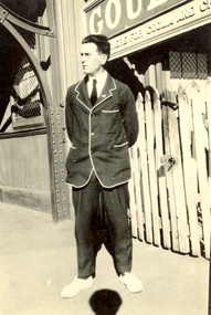
Photograph - Black and White, V. Holt, Frank Wright at Goulbourn Station, New South Wales, 1923
... and a white trimmed blazer. He is standing on the platform... blazer. He is standing on the platform at the Goulbourne railway ...Frank Wright was a renown resident of Smeaton, where he was born. He lived at Laura Villa, and attended Smeaton State School. His father William was a gold miner and his mother's name was Sarah. Their family won many singing and instrumental awards. Frank was tutored by Percy Code and was awarded a gold medal for the highest marks in the ALCM examinations in the British Colonies at the age of seventeen years. He became the Australian Open Cornet Champion by the age of eighteen. A year later, Frank conducted the City of Ballarat Band, and later the Ballarat Soldiers’ Memorial Band. He formed the Frank Wright Frisco Band and Frank Wright and his Coliseum Orchestra. These bands won many South Street awards, and Frank as conductor won many awards in the Australian Band Championship contest. In 1933 Frank Wright sailed to England to conduct the famous St Hilda’s Band and was later appointed Musical Director of the London County Council, where he organized many amazing concerts in parks, in and around the London district. He was made Professor of Brass and Military Band Scoring and conducted at the Guildhall of Music and Drama. Frank was often invited to adjudicate Brass Band Championships around Europe, in Australia, including South Street and in New Zealand. The Frank Wright Medal at the Royal South Street competition is awarded to an individual recognized as making an outstanding contribution to brass music in Australia.Black and white photograph of a man wearing trousers and a white trimmed blazer. He is standing on the platform at the Goulbourne railway station. The man is Frank Wright.Written in pen on the back - Frank Wright 21, on Goulbourne station N.S.W., Easter 1923frank wright, cornet, conductor, ballarat, goulbourne railway station, blazer -
 Federation University Historical Collection
Photograph - Photograph - Black and White, Train at the Allendale Railway Station, 1922, 1/11/1922
Frank Wright was a renown resident of Smeaton, where he was born. He lived at Laura Villa, and attended Smeaton State School. His father William was a gold miner and his mother's name was Sarah. Their family won many singing and instrumental awards. Frank was tutored by Percy Code and was awarded a gold medal for the highest marks in the ALCM examinations in the British Colonies at the age of seventeen years. He became the Australian Open Cornet Champion by the age of eighteen. A year later, Frank conducted the City of Ballarat Band, and later the Ballarat Soldiers’ Memorial Band. He formed the Frank Wright Frisco Band and Frank Wright and his Coliseum Orchestra. These bands won many South Street awards, and Frank as conductor won many awards in the Australian Band Championship contest. In 1933 Frank Wright sailed to England to conduct the famous St Hilda’s Band and was later appointed Musical Director of the London County Council, where he organized many amazing concerts in parks, in and around the London district. He was made Professor of Brass and Military Band Scoring and conducted at the Guildhall of Music and Drama. Frank was often invited to adjudicate Brass Band Championships around Europe, in Australia, including South Street and in New Zealand. The Frank Wright Medal at the Royal South Street competition is awarded to an individual recognized as making an outstanding contribution to brass music in Australia.Black and white photograph of a steam train standing at Allendale Station. In the background is open countryside. The doors of the carriages are open and there are a few people standing on the platform.Written in pen on back - The 7.50 am train at Allendale R.S. Taken from foot bridge (overhead), 1/11/22, F.W. (au)frank wright, train, allendale, station, steam train, railway