Showing 119 items
matching railways scales
-
 Mont De Lancey
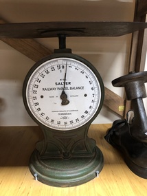
Scales
Green cast iron scales, with a white dial and black measurements around the dial, with a metal plate on top.'No. 56 Salter Railway Parcel Balance Made in England Common-Wealth of Australia To Weigh 28 lb'balances -
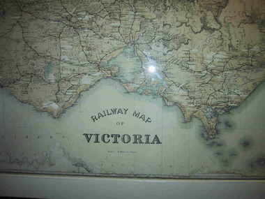 Parks Victoria - Mount Buffalo Chalet
Map, "Railway Map of Victoria"
Large framed map of Victoria, showing Victorias extensive rail network. Printed by Victorian Railways and is one of a number of 'framed pictures, particularly photographs of scenery, which have always been a feature of the Chalet.' (Pg 83. Historica, 2011) This map has been a permanent fixture situated in the hallway alongside the ballroom leading to the ski hire area since the 1950's and most likely earlier. Listed in Draft Inventory of Significant Collection ItemsLarge railway map of Victoria, Melbourne & Ballarat framed in white painted wood. Scale eight miles to one inch. Areas of the map have been whited out.Yes -
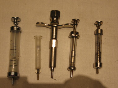 Parks Victoria - Mount Buffalo Chalet
Syringes
'A range of first aid supplies, including older types of stretchers and syringes emphasise the importance given over the years to emergency equipment and to the need for remedial items such as bedpans and invalid cups.' (Pg. 110. Historica) For many years whilst under Railways Management the First Aid Room was opposite the stairs leading down to the Café, on the left hand side leading up to the Dining Room. Here skiing and recreational injuries were attended to.Listed in Draft Inventory of Significant Collection items. Appendix A.3.Staff Equipment. (Pg 167 Historica).Syringes: from .01 till ..04 they have a scale ,they are made with Glass, .01 5ml .02 1ml, .03 20ml, .04 22ml, .05 are made with metal..01 British made 200`C, Everett .02 Gima .03 JJEFF, record british make original .04 original record .05 W.G.LTD Sydney -
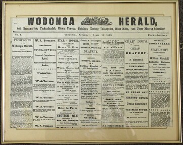 Wodonga & District Historical Society Inc
Photograph - Wodonga Herald, Issue No. 1, Wodonga Herald, April 19, 1873
The establishment of the "Wodonga Herald" was an attempt to create a publication to cater to the needs of the growing local township of Wodonga and the surrounding townships. The proponents of the publication aimed to promote the area and its interests on a wider scale at the same time as the railways were extending into the district. It was intended for circulation in Wodonga as well as Barnawartha, Yackandandah, Kiewa, Towong, Koetong, Tallangatta, Mitta Mitta and the Upper Murray as well as Chiltern, Brown's Plains. Rutherglen, Wahgunyah, Albury and its vicinity. The publication did not meet is objectives and folded on 4 October 1873. The "Murray and Hume Times" was founded as its successor. It was published in Wodonga and Albury on Tuesdays and Fridays and circulated through the whole of the Murray and Hume Districts. The place the new publication was printed seems to have fluctuated between a printing office in Dean Street, Albury, and the main printing office in Sydney Street, Wodonga. By June 1874 the "Murray and Hume Times" had also run into financial difficulties. In October 1874, only one year after its launch the second paper changed hands to the owner of the Albury Banner, George Adams. This item is significant as it represents one of the earliest newspaper publications for the Wodonga district.A photo of the front page of the first issue of the Wodonga Herald published in Wodonga on Saturday, April 19, 1873. Price Sixpence. The image has been mounted with a card backing in a metal frame. The publication included circulation to Barnawartha, Yackandandah, Kiewa, Towong, Tintaldra, Koetong, Tallangatta, Mitta Mitta and Upper Murray Advertiser.wodonga herald, early wodonga newspapers, the murray and hume times, the albury banner, george adams publisher -
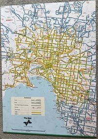 Melbourne Tram Museum
Map, The Met, "Tram and bus Routes showing destination numbers", June 1992
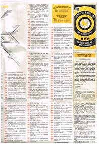
Titled "Tram Routes showing destination numbers". Map dated June 1992 and has been printed with The Met logo. Shows routes with route numbers, names of main destinations, roads, railway stations and rail lines, rivers, scales and Zones. Does not have the CBD insert. Same size as that of item 1099, a 1972 version. Type of map that was placed on the rear of the driver's doors of a W Class tramcar.Demonstrates a The Met produced map used in trramcars.Full colour map or poster printed on paper trimmed from original map and mounted on cardboard.Has some pen marks in the bottom left hand corner.trams, tramways, map, routes, the met -
 Port Melbourne Historical & Preservation Society
Photograph - Aerial view of Port Melbourne, 23 Dec 1945
One of three prints of aerial photographs of Port Melbourne 23.12.1945, showing different areas and to different scales: this one vertical, takes in Station and Town Piers, railyards, Missions to Seamen, Engine Works, temporary US wartime structures, edge of COR buildings, Swallow & Ariell, portion of Wiilliamstown Road. (Smaller copies located in A.06.04.B4)piers and wharves - station pier, piers and wharves - town pier, war - world war ii, built environment, transport - railways, missions to seamen, swallow & ariell ltd -
![Map, Liquidator's sale, 1896. [Woolpack Estate, Bacchus Marsh]](/media/collectors/5e461d8021ea67224c82f2a1/items/6779ee97032b72846b5995f2/item-media/6779ef33032b72846b599b30/item-fit-380x285.jpg) Bacchus Marsh & District Historical Society
Bacchus Marsh & District Historical SocietyMap, Liquidator's sale, 1896. [Woolpack Estate, Bacchus Marsh]
The Woolpack Estate was an area of land owned by various landowners in the Bacchus Marsh area since the early Colonial period of the 1840s. The area was located on the eastern side of the Bacchus Marsh township about 7 kilometers from the town. The Lerderderg River ran through part of the land and so did the Melbourne to Ballarat Road. The historic Woolpack Inn associated with James Crook was also located on this land. By 1896 150 acres of this land was under the control of liquidators for the Federal Bank of Australasia who instructed that the land be sub-divided and sold in lots by public auction. A successful sale was held on 24 June 1896. Most of the blocks of land were sold for higher than expected prices and most of the buyers were people from the town and district of Bacchus Marsh. The map includes various details about the land which is described on the map as an "important sale of rich alluvial irrigable flat land in the Bacchus Marsh Valley, and other properties". The auction was conducted by the local agents W. Anderson and Bence in conjunction with Pearce Brothers also of Bacchus Marsh.A single page paper map showing a plan of 150 acres of land from the Woolpack Estate to be sold in various lots in June 1896. Also shown on the map are lots for sale at Robinson's Farm on Coimadai Creek and allotments near Bacchus Marsh railway station, including lots on Government Road (East Maddingley Road), View Street and Government Road (Parwan Road). No scale provided. The map is pasted into a bound volume containing 76 maps or plans in total. High resolution digital image stored on BMDHS computer network. land sales bacchus marsh, bacchus marsh victoria maps, woolpack estate bacchus marsh victoria -
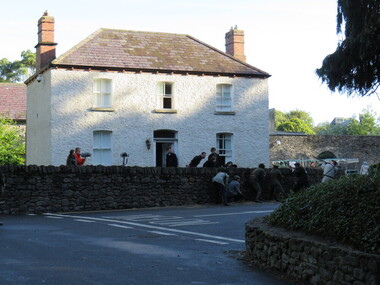 Ballarat Heritage Services
Photograph - Digital Photograph, Dorothy Wickham, Filming Fingal's Finest Day, Malahide Castle, 2016, 09/2016
Generations of the Talbot family have called Malahide Castle home. They played significant roles in Irish political and social life. Set in 260 acres the castle is only 10 minutes from Dublin airport. https://www.malahidecastleandgardens.ie/ According to wikipedia See https://en.wikipedia.org/wiki/Easter_Rising#Fingal In Fingal (or north County Dublin), about 60 Volunteers mobilised near Swords. They belonged to the 5th Battalion of the Dublin Brigade (also known as the Fingal Battalion), and were led by Thomas Ashe and his second in command, Richard Mulcahy. Unlike the rebels elsewhere, the Fingal Battalion successfully employed guerrilla tactics. They set up camp and Ashe split the battalion into four sections: three would undertake operations while the fourth was kept in reserve, guarding camp and foraging for food. The Volunteers moved against the RIC barracks in Swords, Donabate and Garristown, forcing the RIC to surrender and seizing all the weapons. They also damaged railway lines and cut telegraph wires. The railway line at Blanchardstown was bombed to prevent a troop train reaching Dublin. This derailed a cattle train, which had been sent ahead of the troop train. The only large-scale engagement of the Rising, outside Dublin city, was at Ashbourne. On Friday, about 35 Fingal Volunteers surrounded the Ashbourne RIC barracks and called on it to surrender, but the RIC responded with a volley of gunfire. A firefight followed, and the RIC surrendered after the Volunteers attacked the building with a homemade grenade. Before the surrender could be taken, up to sixty RIC men arrived in a convoy, sparking a five-hour gun battle, in which eight RIC men were killed and 18 wounded. Two Volunteers were also killed and five wounded, and a civilian was fatally shot. The RIC surrendered and were disarmed. Ashe let them go after warning them not to fight against the Irish Republic again. Ashe's men camped at Kilsalaghan near Dublin until they received orders to surrender on Saturday. The Fingal Battalion's tactics during the Rising foreshadowed those of the IRA during the War of Independence that followed. Volunteer contingents also mobilised nearby in counties Meath and Louth, but proved unable to link up with the North Dublin unit until after it had surrendered. In County Louth, Volunteers shot dead an RIC man near the village of Castlebellingham on 24 April, in an incident in which 15 RIC men were also taken prisoner.filming, fingal's finest day, malahide castle, ireland -
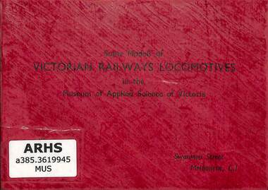 Victorian Railway History Library
Booklet, Museum of Applied Science of Victoria, Some Models of Victorian Railways Locomotives in the Museum of Applied Science of Victoria
A pictorial guide to the 1/48 scale models of locomotives of the Victorian Railways in the Museum of Applied Science of Victoria.ill, p.12.non-fictionA pictorial guide to the 1/48 scale models of locomotives of the Victorian Railways in the Museum of Applied Science of Victoria.model trains - australia - history, tourist railways and museums - victoria -
Whitehorse Historical Society Inc.
Map, Map, Parish of Nunawading, 1850's
A basic map of the Parish of Nunawading to which additions have been made. Scale 70 chains:3.5 inchesA basic map of the Parish of Nunawading to which additions have been made. Scale 70 chains:3.5 inchesmaps, parish of nunawading -
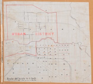 Bacchus Marsh & District Historical Society
Map, Bacchus Marsh Urban District
The date of this map has not been established but the date would be sometime after 1887 as the Bacchus Marsh Railway Station, which opened in 1887, is shown on the map. A single page paper map showing blocks of land in the urban district of Bacchus Marsh. The 'urban district' is indicated by red drawn lines on the map and includes streets and blocks on the northern side of the Werribee River in Bacchus Marsh, and streets and blocks south of the Werribee in Maddingley. Scale 10 chains to 1 inch. The map is pasted into a bound volume containing 76 maps or plans in total. High resolution digital image stored on BMDHS computer network. bacchus marsh victoria maps, maddingley victoria maps -
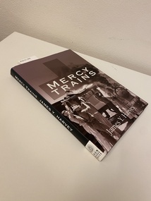 Returned Nurses RSL Sub-branch
Book, James Y Harvey, Mercy trains, 2001
'Mercy trains - Australian Army Ambulance trains during World War II recounts the hitherto untold story of trains provided by Australia's State railway departments to convey the tens of thousands of the armed force's sick and wounded needing transportation across the continent. Conceived as large-scale ambulances to evacuate battle casualties suffered on Australian soil in the event of a landing by enemy forces, their role changed when Australia was spared the trauma of invasion. Instead, the trains becam mobile hospitals: their task to convey invalids from all allied (and enemy) forces to medical centres throughout the nation. One major assignment was to bring south from Queensland casualties evacuated from the battlefields of Papua-New Guinea, whose numbers reached crisis proportions at the close of 1942 and into early 1943. The trains were operated by United States Army personnel for twelve months, one in New South Wales and one in Queensland. Author Jim Harvey spent three years searching through Army (both Australian and U.S.) and railway department files and what he found was a story of demanding military, a penny-pinching government prepared to endanger the lives of train staff rather than permit necessary improvements, some railway operating problems, fires, more than a fair share of floods, a bombing attack, examples of a generosity from caring local communities, a dexicated staff of doctors, nurses, medical orderlies and cooks, supported at all times by sympathetic railwayment of all grades.' [from inside front dust jacked]Black bound book with silver writing on spine. Dust jacket has collage of photographs on front, spine is black with white writing on it.non-fiction'Mercy trains - Australian Army Ambulance trains during World War II recounts the hitherto untold story of trains provided by Australia's State railway departments to convey the tens of thousands of the armed force's sick and wounded needing transportation across the continent. Conceived as large-scale ambulances to evacuate battle casualties suffered on Australian soil in the event of a landing by enemy forces, their role changed when Australia was spared the trauma of invasion. Instead, the trains becam mobile hospitals: their task to convey invalids from all allied (and enemy) forces to medical centres throughout the nation. One major assignment was to bring south from Queensland casualties evacuated from the battlefields of Papua-New Guinea, whose numbers reached crisis proportions at the close of 1942 and into early 1943. The trains were operated by United States Army personnel for twelve months, one in New South Wales and one in Queensland. Author Jim Harvey spent three years searching through Army (both Australian and U.S.) and railway department files and what he found was a story of demanding military, a penny-pinching government prepared to endanger the lives of train staff rather than permit necessary improvements, some railway operating problems, fires, more than a fair share of floods, a bombing attack, examples of a generosity from caring local communities, a dexicated staff of doctors, nurses, medical orderlies and cooks, supported at all times by sympathetic railwayment of all grades.' [from inside front dust jacked]australian nurses, world war two, wwii, ww2, papua new guinea, pacific theatre, homefront, australia -
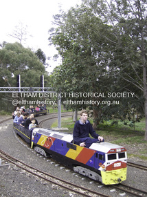 Eltham District Historical Society Inc
Photograph - Digital Photograph, Marguerite Marshall, Diamond Valley Railway, Eltham Lower Park, 7 September 2008
Kids of all ages enjoy the Miniature Railway. Published: Nillumbik Now and Then / Marguerite Marshall 2008; photographs Alan King with Marguerite Marshall.; p163 On Sundays in Eltham thousands of children, mums, dads and grandparents can be seen travelling around Lower Eltham Park in tiny trains. They are among the two and half million passengers who have travelled on the Diamond Valley Railway since it officially began in 1961. The miniature railway originally operated from the 1940s at Chelsworth Park, Ivanhoe, until flooding caused it to be moved to the Eltham Lower Park in 1959. The railway is modelled on the 1920s era – the heyday of passenger rail travel – and the trains are built on a scale of two inches to the foot (1/6). Although not exact replicas, trains include models of the Spirit of Progress, Puffing Billy, The Overland, Dog Boxes, Vic Rail S class, G class and a NSW 81 Class. The three and a half kilometres of track is set amongst native plants and picnic areas. A friendly hoot or the clang of a bell occasionally punctuates the tranquillity as a train emerges from a treed bend with passengers excitedly waving to onlookers. For $3 the train takes you on a 13-minute two-kilometre ride. Passengers sit in single file in the narrow train, which clatters along tracks built to the scale of the Australian narrow gauge of three feet six inches (1.1m). These are used in Queensland, South Australia, Tasmania and Western Australia. Safety standards are stringently kept. Even before you buy a ticket notices tell you that you must wear closed shoes. You can even borrow these, and you are given a pair of socks for the ride! Blue-overalled volunteers check tickets, see you aboard, and drive the train. They are mainly retired men who can at last devote their time to what little boys dream of – playing with trains. Passengers are instructed in safe behaviour, then the station master waves a white flag and off we go. The guard sits at the back with his whistle and green flag at the ready. The winding track, fringed by native trees and bushes planted by volunteers, stands on crown land managed by Nillumbik Council. The train clatters along the track and crosses a bridge over a drain elevated by name to The Blow Fly Creek. We pass by Meadmore Junction at a speed of three kilometres an hour. Then on through a tunnel, accompanied by squeals of delight, and after a few moments of blackness, light glimmers at the end. On we go, past the original platform, along another route past busy Main Road through Pine Creek Station, over a bridge and through another tunnel with more screams of delight.Then a signal stops us before the ‘all clear’ to return to our original point of departure. The railway services its passengers – the largest number of any miniature railway in Australia – with a fleet including: six diesel locomotives, three steam locomotives, eight sets of passenger cars and one battery electric Dog Box set. Members also privately own 20 locomotives and powered carriage sets as well as four carriage sets.1 All the trains are stored on-site in workshops, sheds and a tunnel. The railway is entirely run by volunteers, so that all ticket money is used for maintenance and extensions, and some goes to local charities. Since 1991, the entire railway has been rebuilt, including an upgraded signalling system. About half of the 120 volunteer members are active with about 35 working each Sunday, and a dozen or so working every Wednesday. Members are trained to positions of station assistant, booking officer, train guard, train driver or signalman. Members construct new carriages and locomotives as well as maintaining track, signalling and rolling stock.This collection of almost 130 photos about places and people within the Shire of Nillumbik, an urban and rural municipality in Melbourne's north, contributes to an understanding of the history of the Shire. Published in 2008 immediately prior to the Black Saturday bushfires of February 7, 2009, it documents sites that were impacted, and in some cases destroyed by the fires. It includes photographs taken especially for the publication, creating a unique time capsule representing the Shire in the early 21st century. It remains the most recent comprehenesive publication devoted to the Shire's history connecting local residents to the past. nillumbik now and then (marshall-king) collection, diamond valley railway, eltham lower park -
Port Melbourne Historical & Preservation Society
Map - MMBW, c. 1894
Melbourne and Metropolitan Board of Works 1894, Plan number 18 Segments Shown: Between 322 - 486 Smaller scale map incorporating piers, lagoon and town north to beyond boundaryIn pencil: "7/7/94" (Which is the copyright date)engineering - board of works, piers and wharves - railway pier, piers and wharves - town pier, sandridge lagoon, transport - tramways, transport - railways, gasworks, built environment -
Coal Creek Community Park & Museum
Equipment - Measuring beaker
Used in Manning Chemist, Flinders Street Railway Station, Melbourne until 1984.Glass measure with small pouring lip, and graduated measurement on side. No handle ( i ) on top of measure scale VIC Pint 1- Fl oz 20, 18, 16, 14. graduations on measure scale -
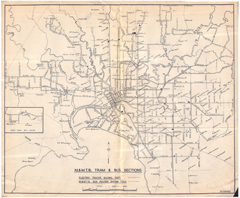 Melbourne Tram Museum
Map, Melbourne & Metropolitan Tramways Board (MMTB), "MMTB Tram and Bus Sections", mid 1960's?
Map - photocopy - titled "MMTB Tram and Bus Sections" showing tram tracks and bus routes, drawing No. P13842, c mid 1960's, Footscray and Point Ormond shown as bus. Shows railway lines, station, some cross streets. Scale 1"=1 Mile.trams, tramways, map, buses, melbourne, footscray -
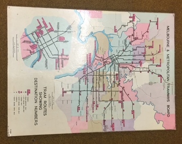 Melbourne Tram Museum
Map, Melbourne & Metropolitan Tramways Board, Del J. Chau, "Tram Routes showing destination numbers", 1972
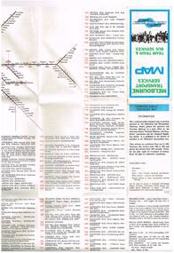
Titled "Tram Routes showing destination numbers". Map dated 1972, showing routes with route numbers, including short working, names of main destinations, roads, railway stations and rail lines, municipalities, rivers, scales, city section in detail, depots and Sunday only services. In bottom right hand corner has number P.14431, Del J. Chau 1972. The original has been altered to show the Bundoora, La Trobe University and East Burwood lines and the change to Airport West. Type of map that was placed on the rear of the driver's doors of a W Class tramcar.Demonstrates a MMTB produced map used in trramcars.Full colour map or poster printed on heavy cardboard.trams, tramways, mmtb, map, routes -
 Melbourne Tram Museum
Map, Ministry of Transport, "Metropolitan Transport Services Map - Melbourne Tram, Train and Bus Services", 10/1971
Fold out map (27 sections 9 across x 3 deep), coloured of Melbourne's Tram and Bus routes, route numbers, rail lines, detailed for the central part of Melbourne. On rear description of routes, private bus routes and map of Melbourne metro lines. Has contact details for bookings and lost property etc. Priced at 10c. Launched in a newspaper advert 26/10/1971. Has map scale in miles. 2nd copy added 16/7/2014On front cover in ink "#1" in top right hand corner and "4 G 33" along bottom edge.trams, tramways, melbourne, map, tram & bus services, railways, mmtb, minister for transport -
 Melbourne Tram Museum
Map, Ministry of Transport, "Melbourne Transport Services Map - Tram, Train and Bus Services", c1975
Fold out map (27 sections 9 across x 3 deep), coloured of Melbourne's Tram and Bus routes, route numbers, rail lines, detailed for the central part of Melbourne and insert section for Frankston. On rear description of routes, private bus routes and map of Melbourne metro lines. Has contact details for bookings and lost property etc. Not priced. Not dated, but circa 1975 - has map scale in kms and route 59 to Essendon Airport still extends into Airport. 2nd copy added 16/7/2014. See Reg Item 521 for issue No.. 2, 1974.On front cover in ink "issue #3" in top right hand corner and "4 G 33" along bottom edge.trams, tramways, melbourne, map, tram & bus services, railways, mmtb, minister for transport -
![Map, Ballarat and Gordons Lane Plan of Land required [for railway line work]](/media/collectors/5e461d8021ea67224c82f2a1/items/676ff3a62c3783fe00b96a8d/item-media/676ff4a42c3783fe00b96cb6/item-fit-380x285.jpg) Bacchus Marsh & District Historical Society
Bacchus Marsh & District Historical SocietyMap, Ballarat and Gordons Lane Plan of Land required [for railway line work]
The railway line from Melbourne to Bacchus Marsh was completed in February 1887. After this date work continued to extend the line to Ballan. This map indicates a portion of land only a few hundred metres west of the Bacchus Marsh railway station which would have been among the first stages of the line to Ballan to have been constructed. This suggests the date of this map to be in the late 1880s.Single page map showing land required for railway line work near Griffith Street, Bacchus Marsh. Scale 10 chains to 1 inch. Hand-written on the map are the exact distances between Bacchus Marsh and Gordons (Gordon) and between Bacchus Marsh and Melbourne as measured from the corner of Maddingley Road and Station Street. Distances recorded are in miles, chains and links. The land required for the railway works is marked in red ink and runs through an area known as Kennedy's Gully. Part of a set of maps which are pasted into a bound volume containing 76 maps or plans in total. High resolution digital image stored on BMDHS computer network. bacchus marsh victoria history, maddingley victoria history, railway lines -
 Bendigo Historical Society Inc.
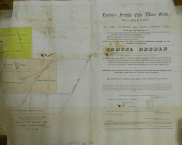
Document - MARKS COLLECTION: BOUNDY'S FREEHOLD GOLD MINES MALMSBURY
Plan/advertisement 1888 for the sale of the Boundy's Freehold Gold Mines Malmsbury, 260 acres of auriferous and arable freehold land. Document contains map of mines, names include O'Connors Freehold Company, Egyptian Company, Queen's Birthday Company, No.1 South Queen Company, Madam O'Connor's company, Extended South Queen's Birthday Company. Scale 10 chains to one inch. Taken from Mr. H. Archdale's Plan by Walter Sleeman, Mining Mgr., Oct 9th. 1888. On RH side of map Daylesford Road to Malmsbury marked. The land is only about two miles from the Malmsbury railway station. On back of document letter from Henry Nutman, Mining Manager, Queens Birthday Company; Report on Plan Walter Skleeman, M.M.; letter to S. Deeble, 35 Queen St., Melbourne with report on mine from George Jenkyn and Mining Manager's Report in Argus 24th.October 1888.mine, gold, boundy's freehold gold mine -
 Bacchus Marsh & District Historical Society
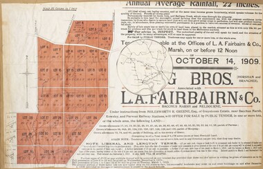
Map, Greystones Estate Land Sale 1909
This map was produced sometime around mid 1909 to advertise portions of land from the Greystones Estate for sale by public tender. The selling agents were Young Brothers of Horsham and L.A. Fairbairn of Bacchus Marsh and Melbourne. The seller was Molesworth R. Greene who was a pioneer pastoralist in the Bacchus Marsh area and had also acquired other properties in Victoria and interstate. Molesworth Greene died in 1916 so this sale came towards the end of his life. A total of 4,176 acres was offered for sale in multiple lots. Successful tenderers could buy single or multiple lots. The results of the sale were reported in the Bacchus Marsh Express newspaper on the 16th October 1909, page 3. At the sale a total of 3, 420 acres was sold. A single page paper map showing portions of land for sale from the Greystones Estate near Bacchus Marsh. The map includes extensive details about the property, number of allotments for sale, terms and conditions of the sale and prices. The map includes an inserted reference map showing the location of the property in relation to Melbourne, Geelong, Ballarat and Castlemaine. The top of the map appears to be missing resulting in some loss of the text. The sale notice in the Bacchus Marsh Express of 10 July, 1909, page 3, column 1 appears to duplicate the text overall in the auction plan. Based on this the missing text is likely to be: "Important Subdivisional Sale 'Of Portion of One of the Best and Most Favourably known Estates IN THE RENOWNED BACCHUS MARSH DISTRICT. And situated only six miles from that prosperous township, two miles from Rowsley, and three miles from Parwan, all Railway towns, connected with the Estate by metal roads." Scale: 20 chains to 1 inch The map is pasted into a bound volume containing 76 maps or plans in total. bacchus marsh victoria maps, land sales, land sales bacchus marsh, greystones estate bacchus marsh, molesworth r. green 1827-1916, land sales rowsley -
Linton and District Historical Society Inc
Plan, Floor plan of Railway Hotel, Linton, undated
It is not known when the plan was drawn up or by whom.Laminated blueprint, showing 1/8 scale floor and block plan of the Railway Hotel in Sussex Street, Linton. Drawn in white ink on blue paper.railway hotel linton, maps and plans, floor plans -
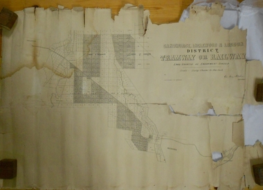 Bendigo Historical Society Inc.
Map - MARKS COLLECTION: TRAMWAY OR RAILWAY MAP SANDHURST
Original map of 'land granted as endowment' for tramway or railway. On top Rh corner of map, in bold print 'Sandhurst, Inglewood & Loddon district Tramway or Railway. Land granted as endowment shaded, scale 60 chains to 1 inch. Lithographed by J & W. Holmes, Lith. Sandhurst'. Signed by Geo Avery Fletcher, Engineer. Map shows Parish of Leichardt, Parish of Yarraberb, Parish of Bridgwater and a section of Marong. On bottom RH corner, is small map of Sandhurst, showing railway reserve. Top LH corner, Inglewood. Map shows route of railway line from Sandhurst to Inglewood.map, marks collection, railway, inglewood -
 Whitehorse Historical Society Inc.
Map - Parish Map, Parish of Nunawading, 1892
A map copied from 'Directory maps - parishes and counties' dated 26 Nov 1892. Compiled and lithographed by G.S. Bonney. The map includes roads, railway, stations, names of property owners. It has a scale [ca. 1:31,680] 40 chains to an 1 inch.A map copied from 'Directory maps - parishes and counties' dated 26 Nov 1892. Compiled and lithographed by G.S. Bonney. The map includes roads, railway, stations, names of property owners. It has a scale [ca. 1:31,680] 40 chains to an 1 inch.non-fictionA map copied from 'Directory maps - parishes and counties' dated 26 Nov 1892. Compiled and lithographed by G.S. Bonney. The map includes roads, railway, stations, names of property owners. It has a scale [ca. 1:31,680] 40 chains to an 1 inch.maps, parish of nunawading -
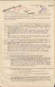 Bendigo Historical Society Inc.
Document - MCCOLL, RANKIN AND STANISTREET COLLECTION: GOLD MINING LEASE NORTH DEBORAH MINING COMPANY, 29th August, 1950
6 page indenture, plus plan, between King George V and North Deborah Mining Company in the Parish of Sandhurst, dated 29th August, 1950 to operate a gold mine. Indenture numbered 11231 Bendigo, Vol 331 and Folio 36457. Plan shows Hargreaves Street, Violet Street, Lily Street, Sullivan Street railway line, and leases numbered, 11230; 2107; 11062, 11033, 11013, 11219, 11175. Shafts and tracks indicated. Dam shown on lease 11013. Scale 8 CHAINS TO A INCH. Coloured key to plan shows depths, Crown Land, and surface excised. Total area of lease 48 acres, 3 roods, 22 perches.bendigo, mining, north deborag mining company, north deborah mining company, hargreaves, violet, lilly, sullivan streets. -
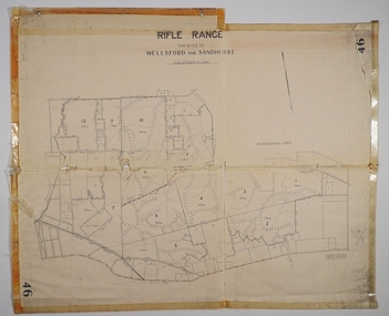 Bendigo Historical Society Inc.
Map - CAMPBELL COLLECTION: BENDIGO AND DISTRICT MAPS
Map. Rifle Range, Parishes of Wellsford and Sandhurst. Scale 20 chains to 1 inch. Total area in plan is 5916 acres. Wallan and Bendigo Railway to Axedale Township and station 8 miles, to Longlea Railway Station 2 1/2 - 3 miles. Rifle Range. Compiled in W.P.B. from Assessment and Parish Plans, by H.A.D. 8-7-29H.A.D.(Darby).map, bendigo, allotments, bendigo rifle range, sandhurst parish, wellsford parish -
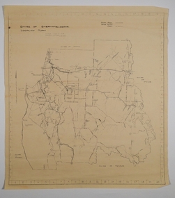 Bendigo Historical Society Inc.
Map - CAMPBELL COLLECTION: BENDIGO AND DISTRICT MAPS, 21-8-1972
Map. Shire of Strathfieldsaye, Locality Plan. Scale I inch=1 mile. Shire of Huntly, Shire of McIvor, City of Bendigo, Shire of Marong, Shire of Maldon, Shire of Metcalfe. Lake Eppalock. Mileage markers on some roads. Melbourne to Bendigo Railway Line, Big Hill Tunnel, Mt.Herbert 1596.Axedale Township, Strathfieldsaye Township.M.Higgs 21-8-1972map, bendigo, locality plan -
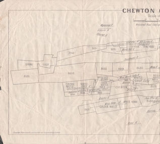 Bendigo Historical Society Inc.
Map - MINING REPORTS - PLAN OF CHEWTON GOLDFIELD 1937
Plan of the Chewton Goldfield with Scale Measurement in chains. Plan shows the township of Chewton with the reefs and leases, the railway line and the Main Castlemaine - Melbourne Road. Also, the Eureka Vineyard. Issued by The Stock Exchange of Melbourne, April 1937. Leases named are: Central Wattle Gully, Wattle Gully United, Wattle Gully Extended, South Wattle Gully, Golden Wattle, Chewton, White Horse, Wattle Gully, North Wattle Gully, North Chewton, Upper Barkly, Post Office Hill, Misima United, Argus Hill, Chapmans, Chewton Prospecting Co, Fiji Gold & Gold Mines of Fiji and Nimrod. Stamp in the top right corner: Edward Dyason & Co. - Queen St. Melbourne. Sharebrokers.map, mining reports, plan of chewton goldfield, edward dyason & co, the stock exchange of melbourne, central wattle gully, wattle gully united, wattle gully extended, south wattle gully, golden wattle, chewton, white horse, wattle gully, north wattle gully, north chewton, upper barkly, post office hill, misima united, argus hill, chapmans, chewton prospecting co, fiji gold & gold mines of fiji, nimrod