Showing 158 items
matching residential garden
-
 City of Moorabbin Historical Society (Operating the Box Cottage Museum)
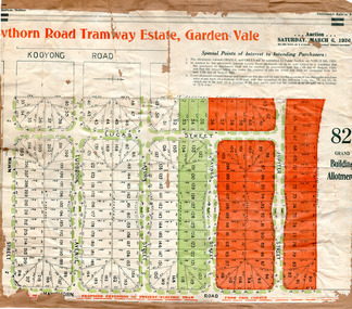
Flyer - Hawthorn Road Tramway Estate, Garden Vale, 1920
At the end of World War One, there was a renewed interest in residential land and a number of estates opened up in the Municipality of Moorabbin.Example of the progress of the Municipality of MoorabbinAdvertising flyer for auction of real estate sales - plan of building blocks for saleHawthorn Road Tramway Estate, Auction 6 March 1920, 82 building allotmentshawthorn road, jupiter street, raynes street, saturn street, ludbrook avenue, wawn street, lucas street, garden vale, real estate, acution, moorabbin -
 City of Moorabbin Historical Society (Operating the Box Cottage Museum)
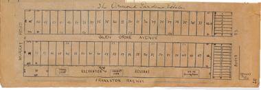
Plan - Ormond Garden Estate, Ormond, 1920
At the end of World War One, there was a renewed interest in residential land and a number of estates opened up in the Municipality of Moorabbin. Ormond Garden Estate was auctioned on Saturday 10 April, 1920.Example of the progress of the Municipality of MoorabbinHand drawn plan of subdivisionOrmond Garden Estatenorth road, glen orme avenue, murray road, ormond, auction, real estate -
 City of Moorabbin Historical Society (Operating the Box Cottage Museum)
Document - Tenth Anniversary - Presbyterian Church East Bentleigh, 1957 - 1967, 1967
... for the growing population of Bentleigh when the market gardens were ...Presbyterian Church East Bentleigh, built in 1957 in Cecil Street East Bentleigh. The site and building is now (2022) being used by Chabad, Bentleigh, which serves to cater to the needs of the Jewish Community.Presbyterian Church Bentleigh was formed to cater for the growing population of Bentleigh when the market gardens were subdivided into residential blocks.Document with blue cover, 18 pages. Contains text and pictures.parish of moorabbin, city of moorabbin, county of bourke, shire of moorabbin, market gardeners, presbyterian church east bentleigh, cecil street, east bentleigh, subdivision of land, religion -
 Bendigo Historical Society Inc.
Photograph - T C WATTS & SON COLLECTION: 25 WEBSTER STREET, BENDIGO, 1929
Thomas Crouch Watts was born on March 7th. 1865, to Joseph and Susan Watts. Before the real estate business commenced, Thomas and his brother were in partnership as booksellers and stationers in a shop at View Point. Thomas lived in a fine house in Rowan Street, which was called 'Ottawa' Thomas started his real estate business in the early 1900s in a shop in View Street. His daughter Edna was the book keeper and typist, Stewart Watson was the salesman and Stanley Phipps (Edith Lunn's father) was the property manager and valuer. When Thomas Watts died in 1914, his daughter took over the running of the business. She married Stewart Watson in 1918. Eventually the name of the business was changed to Bishop and Earl. From a letter from Edith Lunn re T.C. Watts & Son. 'The firm of T.C. Watts & Son later became Bishop and Earl. When the firm of Bishop and Earl ceased to operate after the death of Edith Lunn's father, S.P. Bishop, Miss. June Parry, Secretary of the BHS was a member of staff. June rescued all the photos of properties listed for sale from the office and placed them into the custody of the BHS.' Black and white original photograph mounted on grey cardboard. Weatherboard house, corrugated iron roof. Return verandah with wooden decoration. 1 chimney. 2 decorative gables above windows. Garden with lawn, shrubs and garden seat. Written on back of image 'H. Liddall, Webster Street. Terms £500 bal 61/2 %. £775 on 30.1.41 £250 deposit, low interest to be arranged. 25 Webster Street. White sticker attached to bottom of photo board ' December 1927 Pyke Street - Bendigo £1150' 2012 photo of house attached to record.Frank A. Jeffree Photo Bendigoplace, building, residential -
 Bendigo Historical Society Inc.
Photograph - T C WATTS & SON - QUEEN STREET, 1930
BHS CollectionBlack and white photograph mounted on rectangular grey board. House, weatherboard, 3 gable rooves and small gabled portico. All gables decorated with rough cast and wooden slats. Decorative chimneys with pots, verandah posts with capitals. Tall palm tree in established garden picket fence, with ornate fence posts. Creeper over gateway. Queen Street.Frank A. Jeffree Bendigoplace, building, residential, stamped on back in rectangle ''t.c. watts and son/auctioneer/estate agents/253 mitchell street/bendigo'' stamped on back in circle ''royal historical society of victoria, bendigo branch'' -
 Bendigo Historical Society Inc.
Photograph - T C WATTS & SON COLLECTION: HOUSE, 1930
BHS CollectionBlack and white photograph mounted on rectangular brown board. House, rendered, front gable with vent, bow window, corrugated iron roof, porch, established garden, chimney. Bendigo residence, but no address given.Frank A. Jeffree, Bendigoresidential, bendigo branch'', house -
 Bendigo Historical Society Inc.
Photograph - T C WATTS & SON COLLECTION: 29 PYKE STREET, BENDIGO, 1927
Thomas Crouch Watts was born on March 7th. 1865, to Joseph and Susan Watts. Before the real estate business commenced, Thomas and his brother were in partnership as booksellers and stationers in a shop at View Point. Thomas lived in a fine house in Rowan Street, which was called 'Ottawa' Thomas started his real estate business in the early 1900s in a shop in View Street. His daughter Edna was the book keeper and typist, Stewart Watson was the salesman and Stanley Phipps (Edith Lunn's father) was the property manager and valuer. When Thomas Watts died in 1914, his daughter took over the running of the business. She married Stewart Watson in 1918. Eventually the name of the business was changed to Bishop and Earl. From a letter from Edith Lunn re T.C. Watts & Son. 'The firm of T.C. Watts & Son later became Bishop and Earl. When the firm of Bishop and Earl ceased to operate after the death of Edith Lunn's father, S.P. Bishop, Miss. June Parry, Secretary of the BHS was a member of staff. June rescued all the photos of properties listed for sale from the office and placed them into the custody of the BHS.' Black and white original photograph mounted on grey board. House, weatherboard, corrugated iron roof, verandah, picket fence, wooden fretwork on gables and windows. Decoration along roof line, one chimney visible , garden with two palm trees. Bay window RH side. Harrison's Est £1150, 29 Pyke Street Bendigo written on back of image. Date: 9 Dec 1927. stamped on back.A. Jeffree, Bendgoplace, building, residential, previous reg. no. mp81 part of a collection of photographs used by estate agent t.c. watts and sons, bendigo to show potential purchasers. -
 Bendigo Historical Society Inc.
Photograph - T C WATTS & SON COLLECTION: 'TIRRANNIE' GOLDEN SQUARE, 1929
Thomas Crouch Watts was born on March 7th. 1865, to Joseph and Susan Watts. Before the real estate business commenced, Thomas and his brother were in partnership as booksellers and stationers in a shop at View Point. Thomas lived in a fine house in Rowan Street, which was called 'Ottawa' Thomas started his real estate business in the early 1900s in a shop in View Street. His daughter Edna was the book keeper and typist, Stewart Watson was the salesman and Stanley Phipps (Edith Lunn's father) was the property manager and valuer. When Thomas Watts died in 1914, his daughter took over the running of the business. She married Stewart Watson in 1918. Eventually the name of the business was changed to Bishop and Earl. From a letter from Edith Lunn re T.C. Watts & Son. 'The firm of T.C. Watts & Son later became Bishop and Earl. When the firm of Bishop and Earl ceased to operate after the death of Edith Lunn's father, S.P. Bishop, Miss. June Parry, Secretary of the BHS was a member of staff. June rescued all the photos of properties listed for sale from the office and placed them into the custody of the BHS.'Black and white original photographs (3) mounted on rectangular brown board. House, weatherboard, corrugated iron roof, return verandah with crossed wooden balustrade.4 chimneys. Garden with small palm tree. On back : Mr. Taylor.. 'Tirrannie', Golden Square, £ 2100 , inc. billiard table, linos, overmantle, 4 1/2 acres. 'April 1929' written faintly on back of one image. On front a sticker attached ' April 1929 ' Tiirannie' Golden Square, £2500 - 4 1/2 acres' ( possibly a later attachment for display purposes ) Used by Estate Agent T.C. Watts & Son to show potential purchases in 1929. Previous Reg. No. 'MP 5'. See also Reg. No. 2000.006.01Frank A. Jeffree, Bendigoplace, building, residential -
 Bendigo Historical Society Inc.
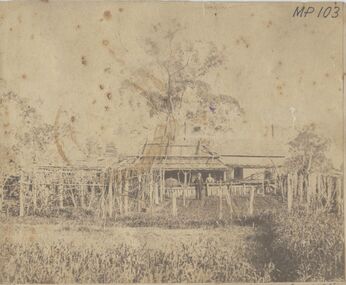
Photograph - HOMESTEAD, BENALLA, 1876, 1876
sepia photo: homestead, shingle roofed with couple standing in front. Garden and trellacing in foregound. On front MP 103/41 Mr. Jonathan Harris, Senr. And Mary his wife, his residence, Benalla, Victoria, Year 1876.buildings, residential, homestead -
 Bendigo Historical Society Inc.
Photograph - MINER'S WEATHERBOARD COTTAGE, 1861
blacka nd white photo of wooden house with unusual side porch entrance; large building at rear. Extensive garden with adult male ( artist ? ), adult female and two children. Picket fence fronting street. On back ' not known' in pencil.Batchelderbuildings, residential, miner's cottage -
 Bendigo Historical Society Inc.
Photograph - VICTORIAN HOUSE WITH TURRET
Sepia photograph mounted on brown embossed board. Large house, stone and brick, corrugated iron roof, gable at side. Round turret with conical roof, s\castellated parapet over square porch at right. 4 chimneys visible. At back, roof which is higher than remainder of roof, with windows along side. Adult male standing oin verandah. Garden with shrubs and grass. Bull nose verandah with iron lace.buildings, residential, victorian -
 Bendigo Historical Society Inc.
Photograph - WEATHERBOARD HOME
Colour photograph: White weatherboard home with black trims. Verandah on three sides, set in garden. Location unknown. Physical description: unmounted photograph.buildings, residential, weatherboard house -
 Bendigo Historical Society Inc.
Photograph - MAHER HOME
Black and white photograph: 'Maher Home', McIvor Road. 317 (printed numbers on back, possibly from developing). Old cottage style home with gable roof and one chimney on left. Set in an untidy garden, behind a broken-down picket fence. Physical condition: unmounted. Inscriptions/Markings: Maher Home, McIvor Road.buildings, residential, victorian -
 Bendigo Historical Society Inc.
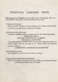
Document - FORTUNA COLLECTION: POSTER - FORTUNA GARDEN FETE 1964, 1964
Double-side Poster - Fortuna Garden Fete 14/11/1964 Description of stalls, raffles, afternoon tea and children's entertainnment. Other side (reverse) has map of grounds with location of activities, toilets, St.John's Ambulance.buildings, residential, fortuna villa -
 Bendigo Historical Society Inc.
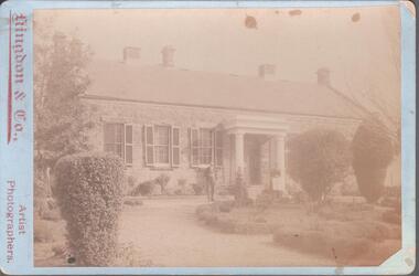
Photograph - ROBINSON COLLECTION: PRIVATE HOUSE
Black and white photograph of a brick house set in a garden. Three people standing at the front. At the bottom Kingdon & Co, Artist Photographers.buildings, residential, brick house -
Whitehorse Historical Society Inc.
Article, Group Garden Turfed Out, 1992
... of the land. Community Gardens Nunawading Youth Residential Centre ...The proposed Government sale of part of Nunawading Youth Residential Centre has forced one of Nunawading's Community Gardens out of its home.The proposed Government sale of part of Nunawading Youth Residential Centre has forced one of Nunawading's Community Gardens out of its home. The families involved are very upset, but the Council has no formal agreement with the Government over the use of the land.The proposed Government sale of part of Nunawading Youth Residential Centre has forced one of Nunawading's Community Gardens out of its home. community gardens, nunawading youth residential centre, community services victoria, nunawading community gardens -
 Whitehorse Historical Society Inc.
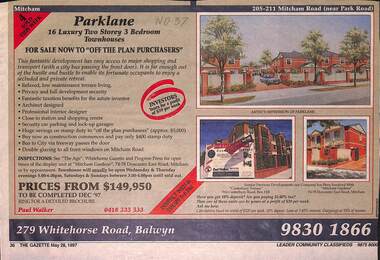
Newspaper - Advertisement, Parklane, 1/05/1997
Cutting of advertisement for Parklane '16 luxury two storey, 3 bedroom townhouses' at 205 Mitcham Road, (near Park Road). Agent Paul walker. Colour drawing. Also photographs of Canterbury Terrace, 910 Canterbury Road, Box Hill and Mitcham Gardens, Doncaster East Road, Mitcham. In Nunawading Gazette, 28th May, 1997parklane;, mitcham road, mitcham, residential development -
Whitehorse Historical Society Inc.
Document, Joan Hornabrook
... Hornabrook's association with the Forest Hill Residential Kindergarten ...Life Governorship Certificate for Joan Hornabrook, from the Free Kindergarten Union of Victoria, 29 June 1978.Life Governorship Certificate for Joan Hornabrook, from the Free Kindergarten Union of Victoria, 29 June 1978. With letter from Meg Hornabrook outlining Joan Hornabrook's association with the Forest Hill Residential Kindergarten, and a plan of the Kindergarten's vegetable garden.Life Governorship Certificate for Joan Hornabrook, from the Free Kindergarten Union of Victoria, 29 June 1978. forest hill residential kindergarten, hornabrook, joan, free kindergarten union of victoria -
 Northern District School of Nursing. Managed by Bendigo Historical Society Inc.
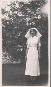
Photograph - Training School 16
The Northern District School of Nursing opened in 1950 in to address the issues around nurse recruitment, training and education that had previously been hospital based. The residential school was to provide theoretical and in-house education and practical training over three years. The students would also receive practical hands-on training in the wards of associated hospitals. The Northern District School of Nursing operated from Lister House, Rowan Street, Bendigo. It was the first independent school of nursing in Victoria and continued until it closed in 1989.Black and white photograph of a nurse in uniform standing in a gardenSister Joan Painter December 1956 written on the back.ndsn, pts16 -
 Northern District School of Nursing. Managed by Bendigo Historical Society Inc.
Photograph - School 21
The Northern District School of Nursing opened in 1950 in to address the issues around nurse recruitment, training and education that had previously been hospital based. The residential school was to provide theoretical and in-house education and practical training over three years. The students would also receive practical hands-on training in the wards of associated hospitals. The Northern District School of Nursing operated from Lister House, Rowan Street, Bendigo. It was the first independent school of nursing in Victoria and continued until it closed in 1989.Photo of 22 third year nurses attending 3rd year block in Bendigo Nurses Home gardensSchool 21 3rd year Block February 1956 P.T.S. 1954 BNH (Bendigo Nurses Home)second year mildura nurse e.j. thorpe, standing in front of lister house -
 Northern District School of Nursing. Managed by Bendigo Historical Society Inc.
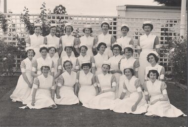
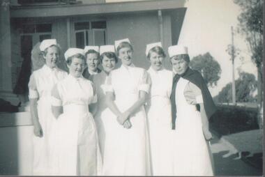
Photograph - School 58 Nurses in the Garden, 1963
The Northern District School of Nursing opened in 1950 to address the issues around nurse recruitment, training and education that had previously been hospital based. The residential school was to provide theoretical and in-house education and practical training over three years. The students would also receive practical hands-on training in the wards of associated hospitals. The Northern District School of Nursing operated from Lister House, Rowan Street, Bendigo. It was the first independent school of nursing in Victoria and continued until it closed in 1989.School 58 Black and White photo of five nurses in the garden at Lister House. On the rear of the photo is written: Northern District School of Nursing 37 Rowan Street, Bendigo, Front Garden - old building, School 58 24/4/1963. Left to Right: L.A. Lawton, P.A. Ripon, ?, Jenny Ayson (Deceased BBH), J. Hoopernurse training, ndsn, lister house, lister house dining room, school 58, 37 rowan street bendigo -
 Northern District School of Nursing. Managed by Bendigo Historical Society Inc.
Photograph - School 58 Nurses in the Garden, 1963
The Northern District School of Nursing opened in 1950 to address the issues around nurse recruitment, training and education that had previously been hospital based. The residential school was to provide theoretical and in-house education and practical training over three years. The students would also receive practical hands-on training in the wards of associated hospitals. The Northern District School of Nursing operated from Lister House, Rowan Street, Bendigo. It was the first independent school of nursing in Victoria and continued until it closed in 1989.School 58 Black and White photo of five nurses in the garden at Lister House. On the rear of the photo is written: Northern District School of Nursing 37 Rowan Street, Bendigo, Front Garden - old building, School 58 24/4/1963. Left to Right: L.A. Lawton, P.A. Ripon, ?, Jenny Ayson (Deceased BBH), ?nurse training, ndsn, lister house, lister house dining room, school 58 -
 Northern District School of Nursing. Managed by Bendigo Historical Society Inc.
Photograph - Schools 21 and 22
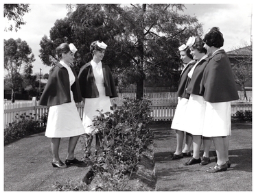
The Northern District School of Nursing opened in 1950 in to address the issues around nurse recruitment, training and education that had previously been hospital based. The residential school was to provide theoretical and in-house education and practical training over three years. The students would also receive practical hands-on training in the wards of associated hospitals. The Northern District School of Nursing operated from Lister House, Rowan Street, Bendigo. It was the first independent school of nursing in Victoria and continued until it closed in 1989.Black and white photograph of three student nurses in casual clothes in the garden at Lister House. C 1955. Sacred Heart Cathedral in the background.Names written on back. L to R - Helen Ryan, Ida Moore and Elaine Sweeney. ?1955 with Sacred Heart Cathedral in background.three student nurses., in garden at lister house. -
 Northern District School of Nursing. Managed by Bendigo Historical Society Inc.
Photograph - Schools 21 and 22
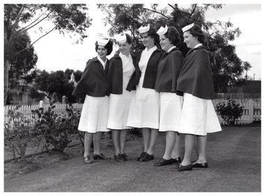
The Northern District School of Nursing opened in 1950 in to address the issues around nurse recruitment, training and education that had previously been hospital based. The residential school was to provide theoretical and in-house education and practical training over three years. The students would also receive practical hands-on training in the wards of associated hospitals. The Northern District School of Nursing operated from Lister House, Rowan Street, Bendigo. It was the first independent school of nursing in Victoria and continued until it closed in 1989.Black and white photograph of seven first year student nurses in garden at Lister House. C 1954Names written on back. L to R - Verna Hoensch, Heather Midgley, Helen Ryan, Margaret Arnoldt, Ida Moore, Rae Eyles. Lister House, Bendigo. 1954 in lister house gardens, seven first year nurses -
 Northern District School of Nursing. Managed by Bendigo Historical Society Inc.
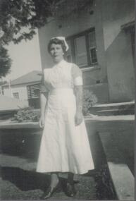
Photograph - Preliminary Training School 22
The Northern District School of Nursing opened in 1950 in to address the issues around nurse recruitment, training and education that had previously been hospital based. The residential school was to provide theoretical and in-house education and practical training over three years. The students would also receive practical hands-on training in the wards of associated hospitals. The Northern District School of Nursing operated from Lister House, Rowan Street, Bendigo. It was the first independent school of nursing in Victoria and continued until it closed in 1989.Black and white photograph of student nurse standing in the front garden at 99 Wattle Street - Nurses' home.Name written on back. Rae Eyles P.T.S. Wattle Street, Bendigo 1954seven student nurses in casual clothes., standing on steps of nurses home. -
 Northern District School of Nursing. Managed by Bendigo Historical Society Inc.
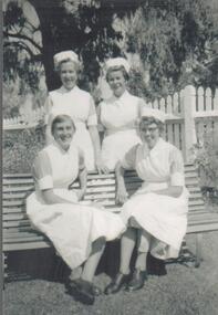
Photograph - School 22
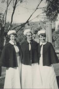
The Northern District School of Nursing opened in 1950 in to address the issues around nurse recruitment, training and education that had previously been hospital based. The residential school was to provide theoretical and in-house education and practical training over three years. The students would also receive practical hands-on training in the wards of associated hospitals. The Northern District School of Nursing operated from Lister House, Rowan Street, Bendigo. It was the first independent school of nursing in Victoria and continued until it closed in 1989.photo of four third year nurses School 22 sitting in a gardenBack Row: Verna Hoensch, Rae Eyles Front Row: Margaret Arnoldt, Ida Moore School 22 1954-1957 four third year nurses school 22, at lister house. -
 Northern District School of Nursing. Managed by Bendigo Historical Society Inc.
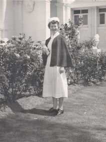
Photograph - 2nd Year nurse
The Northern District School of Nursing opened in 1950 in to address the issues around nurse recruitment, training and education that had previously been hospital based. The residential school was to provide theoretical and in-house education and practical training over three years. The students would also receive practical hands-on training in the wards of associated hospitals. The Northern District School of Nursing operated from Lister House, Rowan Street, Bendigo. It was the first independent school of nursing in Victoria and continued until it closed in 1989.Photo of second year nurse School 23A Ten in uniform in front of Lister House Bendigo 1954. Lister House - Front garden. Nr Elizabeth Joan Thorpe, Mildura, 2nd year. 1954 -57 School 23A. Shield on wall in background - Dr Neptune Scott's family coat of arms. second year mildura nurse e.j. thorpe, standing in front of lister house -
 Northern District School of Nursing. Managed by Bendigo Historical Society Inc.
Photograph - NDSN PTS 97 1981
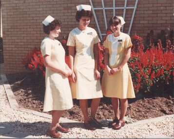
The Northern District School of Nursing opened in 1950 in to address the issues around nurse recruitment, training and education that had previously been hospital based. The residential school was to provide theoretical and in-house education and practical training over three years. The students would also receive practical hands-on training in the wards of associated hospitals. The Northern District School of Nursing operated from Lister House, Rowan Street, Bendigo. It was the first independent school of nursing in Victoria and continued until it closed in 1989.NDSN School 97 PTS 2.2 97 1981 Nurses in yellow uniforms in the garden at Lister House. Three nurses (L to R) Elizabeth White, Mary Spedding & Kerry Langley.NDSN 8593.13 PTS 97 2.2 1981 Three nurses (L to R) Elizabeth White, Mary Spedding & Kerry Langley.ndsn, nursing -
 Department of Health and Human Services
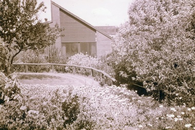
Photograph, Colanda Grounds - Dove Unit gardens
The Colac, Victoria-based Colanda Centre was one of the last Victorian institutions and offered disability accommodation from 1976, when it was established, until 2019, with its closure.Digitised colour photograph of the Colanda Centre's Dove Unit gardens.colanda, colac, disability services, residential services, disability, digitised photograph -
 Department of Health and Human Services
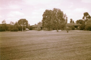
Photograph, Photo of Houses on the Colanda Grounds purposely built for management
The Colac, Victoria-based Colanda Centre was one of the last Victorian institutions and offered disability accommodation from 1976, when it was established, until 2019, with its closure.Digitised colour photograph of the on ground houses at the Colanda Centre. There were eight houses in total, they were built for: Manager of Colanda Head nurse, Engineer, Head Gardener they were never full and in the end no one lived in them because they didn’t want to live on the grounds, not being able to escape work. colanda, colac, disability services, residential services, disability, digitised photograph