Showing 575 items matching "route map"
-
 Melbourne Tram Museum
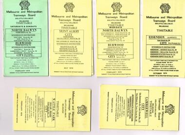
Ephemera - Timetable/s, Melbourne & Metropolitan Tramways Board (MMTB), "MMTB Tram Timetables", 1974
... sections, providing timetables for specific routes, day of week... Trams tramways MMTB Timetables Melbourne Fares Route 23 Route 24 ...Set of 6 MMTB Tram timetables, folded sheets, generally 10 sections, providing timetables for specific routes, day of week giving information on tram times at specific time points, route map, sections and fares and organisation address - 616 Little Collins St. Melbourne. All printed on yellow paper unless noted otherwise. .1 - Route 48, 41, 40, 29, 74, 75, 76, 28 - North Balwyn and Burwood - City - Saturdays and Sundays - Feb. 1974, printed on green paper. .2 - Route 42, 23, 44, 45 and 37, Mont Albert - City - May 1974 .3 - Route 48, 41, 40, 29, 74, 75, 76, 28 - North Balwyn and Burwood - City - Feb. 1974 .4 -Route 59, 49, 52, 51, 81 - Essendon Airport - City - Oct. 1974 .5 - Route 70, 71 and 76 - Wattle Park - City - Feb. 1974 .6 - Route 72, 32 and 73 - Camberwell - City - Feb. 1974trams, tramways, mmtb, timetables, melbourne, fares, route 23, route 24, route 28, route 29, route 32, route 37, route 40, route 41, route 42, route 44, route 45, route 48, route 49, route 51, route 52, route 59, route 70, route 71, route 72, route 73, route 75, route 76, route 81 -
 Melbourne Tram Museum
Ephemera - Timetables - The Met - buses - set of 2, The Met, 1984 and 1985
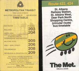
... , timing points, with a description of the route and a map. 1..., with a description of the route and a map. 1 - Bulleen - North Kew - City ...Timetables - provide information on ticketing, fares, timing points, with a description of the route and a map. 1 - Bulleen - North Kew - City, Belford Rd, Collingwood - routes 203, 204, 205, 206, 208, 209 - with the first "The Met" logo - April 1984 2 - St Albans - Deer Park North Shopping Centre - circular route - with the smiley face on wheels logo - dated 18/3/1985.Yields information about MMTB Bus services during the mid 1980s. Set of two The Met timetables, one printed on the folded sheet of yellow paper and the other on white paper.timetable, bulleen, north kew, collingwood, the met, deer park, st albans -
 Melbourne Tram Museum
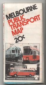
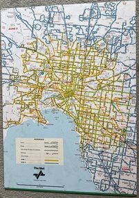
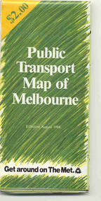
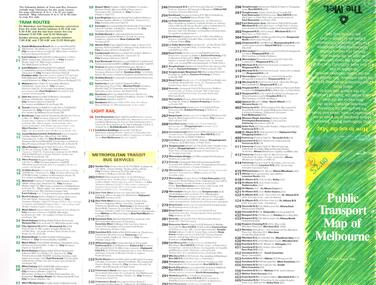
Map, Ministry of Transport, "Melbourne Public Transport Map", c1977
... . On rear description of routes, private bus routes and map... routes and map of Melbourne metro lines. Has contact details ...Fold out map (27 sections 9 across x 3 deep), coloured of Melbourne's Tram and Bus routes, route numbers, rail lines, detailed for the central part of Melbourne and insert section for Frankston. On rear description of routes, private bus routes and map of Melbourne metro lines. Has contact details for bookings and lost property etc. Priced 20c Dated 1977, says No. 6 on bottom of rear cover. Note shows route 59 being cut back to the highway.trams, tramways, melbourne, map, tram & bus services, railways, mmtb, minister for transport -
 Melbourne Tram Museum
Ephemera - Timetable/s, Metropolitan Transit Authority (MTA), "MMTB Bus Timetables", 1984
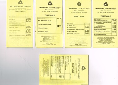
... points, route map, sections and fares and organisation address... points, route map, sections and fares and organisation address ...Set of 5 Metropolitan Transit Bus timetables, folded sheets, generally 8 or 10 sections, providing timetables for specific routes, day of week giving information on tram times at specific time points, route map, sections and fares and organisation address - 616 Little Collins St. Melbourne. All printed on yellow paper unless noted otherwise. .1 - Route 203, 204, 205, 206, 208. 209 - Bulleen, North Kew, Belford Road, Kew, Collingwood and Nicholson and Johnson St - City - April 1984 .2 - Route 223 - Williamstown Road, Footscray Railway Station, Ballarat Road and Highpoint West - July 1984 .3 - Route 246, 247, 248 - Clifton Hill, Elsternwick, Point Ormond and St Kilda Junction - July 1984 .4 - Route 256, 251, 253, 254, 252, 255 - Latrobe University, Northland, West Heidelberg - City - Aug./ 1984 .5 - Route 277, 280, 299. 281 and 268 - services via East Doncaster, North Balwyn and Kew - Warrandyte, Donvale, Shoppingtown - August 1984trams, tramways, metropolitan transit, timetables, melbourne, fares, buses, footscray, latrobe university, northland, heidelberg, warrandyte, doncaster, donvale, bulleen, north kew, williamstown rd, highpoint, clifton hill, elsternwick, point ormond, st kilda junction -
 Melbourne Tram Museum
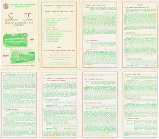
Pamphlet, Melbourne & Metropolitan Tramways Board (MMTB), "Short Trips around Melbourne and Suburbs by Bus and Tram", mid 1960's
... and bus routes - from map date document mid to late 1960's - old... Trams tramways MMTB Map Tourist Trips Fares Routes Pamphlet ...Pamphlet titled "Short Trips around Melbourne and Suburbs by Bus and Tram", two colour printed document folded into 8 on buff coloured paper, featuring 14 various trips around Melbourne, with a detailed description of each route, time, fare and notes. On reverse side is a detailed map of the MMTB tram and bus routes - from map date document mid to late 1960's - old route numbers eg 4D and Point Ormond and Footscray have closed. See also Reg Item 1508 for an earlier version.trams, tramways, mmtb, map, tourist trips, fares, routes -
 Melbourne Tram Museum
Map, Ministry of Transport, "Melbourne Transport Services Map - Tram, Train and Bus Services", c1975
... . On rear description of routes, private bus routes and map.... On rear description of routes, private bus routes and map ...Fold out map (27 sections 9 across x 3 deep), coloured of Melbourne's Tram and Bus routes, route numbers, rail lines, detailed for the central part of Melbourne and insert section for Frankston. On rear description of routes, private bus routes and map of Melbourne metro lines. Has contact details for bookings and lost property etc. Not priced. Not dated, but circa 1975 - has map scale in kms and route 59 to Essendon Airport still extends into Airport. 2nd copy added 16/7/2014. See Reg Item 521 for issue No.. 2, 1974.On front cover in ink "issue #3" in top right hand corner and "4 G 33" along bottom edge.trams, tramways, melbourne, map, tram & bus services, railways, mmtb, minister for transport -
 Melbourne Tram Museum
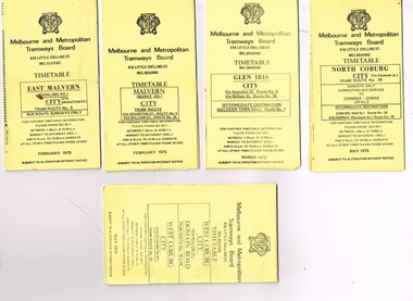
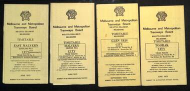
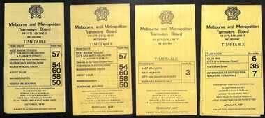
Ephemera - Timetable/s, Melbourne & Metropolitan Tramways Board (MMTB), "MMTB Tram Timetables", 1975
... sections, providing timetables for specific routes, day of week... on tram times at specific time points, route map, sections ...Set of 9 MMTB Tram timetables, folded sheets, generally 10 sections, providing timetables for specific routes, day of week giving information on tram times at specific time points, route map, sections and fares and organisation address - 616 Little Collins St. Melbourne. All printed on yellow paper unless noted otherwise. .1 - Route 3 - East Malvern 3 - Bus Route Sundays Only, Feb. 1975 .2 - Route 5, 35 - Malvern - City .3 - Route 6, 7, 36 - Glen Iris - City .4 - Route 19, 18, 20 - North Coburg - City and Sundays only - Fawkner to Gowrie, Upfield - May 1975 .5 - Route 55, 56, 68 - West Coburg - City - Domain Road - May 1975 .6 - Route 57, 54, 60, 58 and 50 - West Maribyrnong - City - Feb. 1975 .7 - Route 64, 65, 62, 61 - East Brighton - City - June 1975 .8 - Route 66, 67 and 37 - Carnegie - City - June 1975 .9 - Route 82 - Footscray - Highpoint West - Moonee Ponds (Bus service Saturday afternoons and Sundays - November 1975. See Reg Item 2886 for a tramway check ticket for use on the Upfield line.trams, tramways, mmtb, timetables, melbourne, fares, upfield, bus replacement, route 3, route 5, route 6, route 7, route 18, route 19, route 20, route 35, route 36, route 37, route 50, route 54, route 55, route 56, route 57, route 58, route 60, route 61, route 62, route 64, route 65, route 66, route 67, route 68, route 82 -
 Melbourne Tram Museum
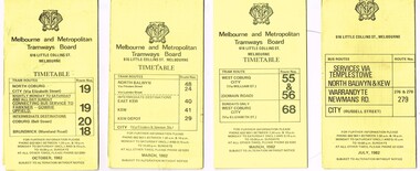
Ephemera - Timetable/s, Metropolitan Transit Authority (MTA), "MMTB Bus Timetables", 1982
... points, route map, sections and fares and organisation address... points, route map, sections and fares and organisation address ...Set of 7 MMTB Tram and Bus timetables, folded sheets, generally 8 or 10 sections, providing timetables for specific routes, day of week giving information on tram times at specific time points, route map, sections and fares and organisation address - 616 Little Collins St. Melbourne. All printed on yellow paper unless noted otherwise. .1 - Routes 19, 20, 18 - North Coburg, and bus service to Fawkner, Gowrie, Upfield - nightly Monday to Saturday and all day Sunday - Oct. 1982 .2 - Route 48, 24, 40, 41, 29 - North Balwyn - City - March 1982 .3 - Route 55, 56 68 - Sunday only via Elizabeth St - March 1982 .4 - Route 276, 278 and 279 - Services via Templestowe, Warrandyte and Newmans Road - City - July 1982 .5 - Route 57, 357 (bus Sundays only), 54, 60, 58, 50 - West Maribyrnong - City - Jan. 1982 .6 - Route 59, 49, 52, 51 and 81 - Essendon Airport - City - March 1982 .7 - Route 203, 204, 205, 206, 208. 209 - Bulleen, North Kew, Belford Road, Kew, Collingwood and Nicholson and Johnson St - City - Sept. 1982trams, tramways, mmtb, timetables, melbourne, fares, buses, bus replacement, trams, upfield, route 18, route 19, route 20, route 24, route 29, route 40, route 41, route 48, route 49, route 50, route 52, route 51, route 54, route 55, route 56, route 57, route 58, route 59, route 60, route 68, route 81, route 357, warrandyte, doncaster, templestowe, kew -
 Melbourne Tram Museum
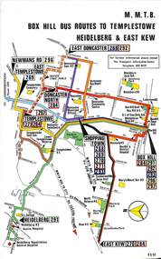
Map, Melbourne & Metropolitan Tramways Board (MMTB), Set of 8 bus route maps, 1977 to 1979
... Series of colour route maps for various bus or groups... Trams tramways Maps Route Guide Route Numbers Routes Buses Box ...Series of colour route maps for various bus or groups of tram lines for the MMTB. Some have the Transport Information Centre telephone printed on them, others have a label stuck on. Some are finished with a plastic laminate finish on either one or both sides. Show the major cross streets, parks, schools, other tram routes, major stop numbers and railway lines. .1 - Box Hill bus routes to Templestowe - R38/82, Heidelberg and East Kew, includes Doncaster, Shoppingtown and Newmans Road. .2 - Clifton Hill - R2/79 - Elsternwick, Point Ormond and St Kilda Junction .3 - Footscray, Sunshine, Deer Park, Nth Altona, Fishermen's Bend, Highpoint and Williamstown Road - R2/79. .4 - Bulleen - City - Port Melbourne - Garden City Bus Route, including Kew, Collingwood - R6/78 .5 - City - Warrandyte and East Doncaster including Newmans Road, Templestowe, East Doncaster, Donvale, Shopping town, and Kew. R3/82. .6 - West Heidelberg, La Trobe University, Northland - R3/81 .7 - Box Hill, Ringwood to East Doncaster and Warrandyte, Park Orchards, North Blackburn R3/82. .8 - Geelong - Herne Hill, Rollins Road, Donnybrook Rd, North Shore and Corio Villagetrams, tramways, maps, route guide, route numbers, routes, buses, box hill, templestowe, doncaster, east kew, heidelberg, clifton hill, point ormond, elsternwick, footscray, sunshine, deer park, north altona, fishermen's bend, highpoint, williamstown rd, bulleen, kew, collingwood, port melbourne, garden city, warrandyte, donvale, la trobe university, northland, ringwood, park orchards, mitcham, blackburn, geelong -
 Melbourne Tram Museum
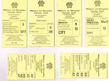
Ephemera - Timetable/s, Melbourne & Metropolitan Tramways Board (MMTB), "MMTB Tram Timetables", 1980
... sections, providing timetables for specific routes, day of week... information on tram times at specific time points, route map, sections ...Set of 12 MMTB Tram timetables, folded sheets, generally 10 sections, providing timetables for specific routes, day of week giving information on tram times at specific time points, route map, sections and fares and organisation address - 616 Little Collins St. Melbourne. All printed on yellow paper unless noted otherwise. .1 - Route 3 - East Malvern and Route 377 - Bus on Sunday only - June 1980 .2 - Route 8 and 88 Toorak - December 1980 .3 - Route 9 and 14 - Northcote - City - Dec. 1980 .4 - Route 42, 23, 44, 45, 47 - Mont Albert - City - Nov. 1980 .5 - Route 61, 62, 64, 64 - East Brighton - City - July 1980 .6 - Route 37, 66 and 67 - Carnegie - City - July 1980 .7 - Route 10, 11, 13 - West Preston - City - November 1980 .8 - Route 69 - St Kilda Beach - Kew - Nov. 1980 .9 - Route 75, 74, 76 and 28 - East Burwood - City - Oct. 1980 .10 - Route 96, 95, 97 - East Brunswick - City - September 1980. .11 - Route 15, 22 - Moreland - City - December 1980 ,12 - Route 1 & 21 - East Coburg - City - December 1980trams, tramways, mmtb, timetables, melbourne, fares, bus replacement, route 1, route 3, route 8, route 9, route 10, route 11, route 13, route 14, route 15, route 21, route 22, route 23, route 28, route 37, route 38, route 42, route 44, route 45, route 47, route 61, route 62, route 64, route 61, route 66, route 67, route 69, route 74, route 75, route 76, route 95, route 96, route 97, route 377 -
 Melbourne Tram Museum
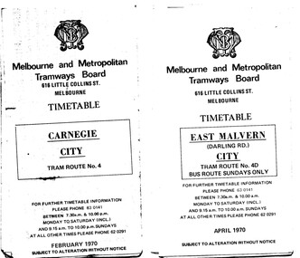
Ephemera - Timetable/s, Melbourne & Metropolitan Tramways Board (MMTB), "MMTB Tram Timetables", 1970
... information on tram times at specific time points, route map, sections... time points, route map, sections and fares and organisation ...Set of 12 MMTB Tram timetables, folded sheets, 10 sections, providing timetables for specific routes, day of week giving information on tram times at specific time points, route map, sections and fares and organisation address - 616 Little Collins St. Melbourne. .1 - Route 4 - Carnegie - City - Feb. 1970. .2 - City Route 4D - East Malvern - April 1970 - notes a bus route on Sundays only .3 - Routes 55 and 56 - West Coburg - City via Domain Road and William St - Sept. 1970 .4 - Route 65 and 64 - East Brighton - City - April 1970 .5 - Route 1, 2, 15 and 16, St Kilda Beach, South Melbourne Beach and City - March 1970. .6 - Route 5 - Malvern Burke Road - City - April 1970 .7 - Routes 48 and 74 - North Balwyn - Burwood - City September 1970 .8 - Route 59 - Essendon - city - July 1970 .9 - Routes 88 and 96 - East Preston - East Brunswick - City - March 1970 .10 - Route 82 - Footscray - Moonee Ponds - Feb 1970 .11 - Routes 48 and 74 - North Balwyn - Burwood - City September 1970 - Saturdays and Sundays, printed on pink paper. .12 - Routes 88 and 96 - East Preston - East Brunswick - City - March 1970 - Saturdays and Sundays, printed on pink paper.trams, tramways, mmtb, timetables, melbourne, fares, route 4, route 4d, route 55, route 56, route 64, route 65, route 1, route 2, route 15, route 16, st kilda beach, carnegie, east malvern, west coburg, east brighton, south melbourne beach, route 5, route 48, route 74, route 88, route 59, route 96, route 82 -
 Melbourne Tram Museum
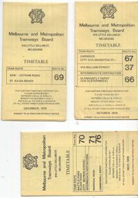
Ephemera - Timetables - MMTB trams - set of 10, Melbourne & Metropolitan Tramways Board (MMTB), 1973
... , and timing points, with a description of the route and a map... points, with a description of the route and a map. Includes ...MMTB Timetables - providing information on ticketing, fares, and timing points, with a description of the route and a map. Includes routes via William St - in the 30s 1 - East Malvern - City - route 3, bus route on Sundays only - June 1973 2 - Malvern Burke Road - City - route 5 and 35, - June 1973 3 - Glen Iris - City - route 6 and 36 - Sept. 1973 4 - Toorak - City - route 8 and 38 - June 1973 5 - South Melbourne and St Kilda Beach - City - routes 10, 12, and 17 - June 1973 6 - St Kilda Beach - South Melbourne Beach - City - routes 15, 16, 53, 55, 1, 2 and 4 - Sept. 1973 7 - Moreland - East Coburg - City - routes 1, 21, 15 and 22 - August 1973 8 - East Brighton - City - routes 64, 65, 62 and 61 - June 1973 9 - Carnegie - City routes 67, 37 and 66 - June 1973 10 - Kew Cotham Road - St Kilda Beach - route 69 - June 1973Yields information about MMTB tram services during 1973Set of 10 MMTB tram timetables - multifolded printed on yellow paper.timetable, mmtb, glen iris, malvern town hall, toorak, route 36, route 8, route 38, route 10, route 12, route 17, route 3, route 5, route 35, route 6, route 1, route 2, route 4, route 21, route 15, route 22, route 64, route 65, route 61, route 62, route 67, route 37, route 66, route 69 -
 Dandenong/Cranbourne RSL Sub Branch
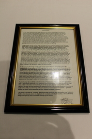
Document - Framed Information Sheet, About The Map, Circa 2000s
... on the route of the map. The map gives due credibility and was released... on the route of the map. The map gives due credibility and was released ...The information sheet belongs with a map showing the Burma Thailand Railway and it's route with the various camps and P.O.W centres. The map was produced over a period of 15 months and drawn in four stages. Shows Hellfire Pass formerly ( The Konyu Cutting). The 50 Kilo Camp in Burma. There were 56 stations and 87 camps on the route of the map. The map gives due credibility and was released as a limited edition of 1000 copies only. Copies of the map are displayed all over the world including Staffordshire in England, University of Houston, National Guard Museum of Texas and on display at the Australian and New Zealand Embassies in Bangkok.Framed information sheet of the map produced to show the various camps and sights along the Burma Thailand railway. The map was produced using a number of older railway maps, including the Escritt translated map and a local Thai road touring map. -
 Melbourne Tram Museum
Map, The Met, "Tram and bus Routes showing destination numbers", June 1992
... Titled "Tram Routes showing destination numbers". Map...Titled "Tram Routes showing destination numbers". Map dated ...Titled "Tram Routes showing destination numbers". Map dated June 1992 and has been printed with The Met logo. Shows routes with route numbers, names of main destinations, roads, railway stations and rail lines, rivers, scales and Zones. Does not have the CBD insert. Same size as that of item 1099, a 1972 version. Type of map that was placed on the rear of the driver's doors of a W Class tramcar.Demonstrates a The Met produced map used in trramcars.Full colour map or poster printed on paper trimmed from original map and mounted on cardboard.Has some pen marks in the bottom left hand corner.trams, tramways, map, routes, the met -
 Melbourne Tram Museum
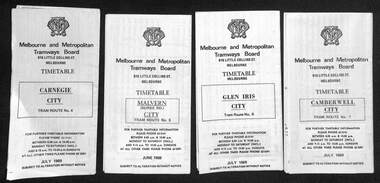
Ephemera - Timetables - MMTB trams - set of 5, Melbourne & Metropolitan Tramways Board (MMTB), 1977 and 1979
... , and timing points, with a description of the route and a map. Not all... points, with a description of the route and a map. Not all ...Timetables - provide information on ticketing, fares, and timing points, with a description of the route and a map. Not all services had been allocated a route number at the time. 1 - West Maribyrnong - City - routes 57, 54, 60, 58 and 50 - Oct. 1979 2 - West Maribyrnong - City - routes 57, 54, 60, 58 and 50 - Feb. 1977 3 - East Malvern (Darling Rd) City - route 3 - Feb. 1977 4 - Glen Iris - City and via William St - routes 6, 36 and 7 - Jan. 1977 5 - Wattle Park - City - routes 70, 71 and 76 - Nov. 1979Yields information about MMTB tram services during the 1970s. Set of 5 MMTB tram timetables - multifolded printed on yellow paper.timetable, mmtb, west maribyrnong, east malvern, glen iris, route 57, route 54, route 60, route 58, route 50, route 3, route 6, route 36, route 7, wattle park, route 70, route 71, route 76 -
 Melbourne Tram Museum
Ephemera - Set of 24, Melbourne & Metropolitan Tramways Board (MMTB), "MMTB Tram Timetables", 1969
... Set of 23 timetables for specific routes, day of week... information on tram times at specific time points, route map, sections ...Set of 23 timetables for specific routes, day of week giving information on tram times at specific time points, route map, sections and fares and organisation address - 616 Little Collins St. Melbourne. All July 1969. The first set of timetables issued in this format. 1- Route 4 - Carnegie - City 2 - Route 5 - Malvern (Burke Rd.) - City 3 - Route 6 - Glen Iris - City 4 - Route 7 - Camberwell - City 5 - Route 8 - Toorak - City 6 - Route 9, 10 and 12 - South Melbourne and St Kilda Beach - City 7 - Routes 10, 11, 9 and 9A - West Preston Northcote - City 8 - Route 1, 2A, 15, 16 - St Kilda Beach - South Melbourne - City 9 - Route 1, 15, 21, 22 - Moreland - East Coburg - City 10 - Route 19 - North Coburg - City 11 - Route 42 - Mont Albert - City 12 - Route 48, 74 - North Balwyn - Burwood - City 13 - ditto - Saturdays and Sundays - printed on pink paper 14 - Route 55, 56 - West Coburg - Domain Road - via William St 15 - Route 57 - West Maribyrnong - City - bus route Sundays only 16 - Route 59 - Essendon Aerodrome - City 17 - Route 64, 65 - East Brighton - via Swanston St/ William St 18 - Route 69 - Kew Cotham Road - St Kilda Beach 19 - Route 70 - Wattle Park - City 20 - Route 77, 78, 79 - Prahran - City, North Richmond - Prahran - St Kilda Beach 21 - Route 82 - Footscray - Moonee Ponds - bus route Saturday afternoon and Sundays 22 - Route 88 and Route 96 - East Preston, East Brunswick - city - July 1969, printed on white paper. - Weekdays and Sundays 23 - Route 88, 96 - East Preston and East Brunswick (Blyth St)< Saturdays, Xmas day and Good Fri - printed on pink paper. 24 - Route 4D - East Malvern (Darling Road) - City, bus route Sundays only Yields information about MMTB Tram services during 1969Set of 24 MMTB Tram timetables, folded sheets.trams, tramways, mmtb, timetables, melbourne, fares, route 69, route 64, route 88, route 96, route 4, route 4d, route 5, route 6, route 7, route 8, route 9, route 9a, route 10, route 11, route 12, route 1, route 15, route 21, route 22, route 2a, route 15, route 16, route 19, route 42, route 48, route 74, route 55, route 56, route 57, route 59, route 65, route 70, route 77, route 78, route 79, route 82 -
 Melbourne Tram Museum
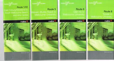
Ephemera - Timetable, Yarra Trams, Set of 22 Yarra Trams timetables, 2003 and 2004
... and route map. .1 - Route 1/22 - East Coburg / Moreland - South..., description of route and route map. .1 - Route 1/22 - East Coburg ...Set of 22 Yarra Trams timetables, green grey cover with route number on cover, giving details of popular destination, check points, use of Metcards and contact details, tram hire, frequency, a Welcome to Swanston Trams, description of route and route map. .1 - Route 1/22 - East Coburg / Moreland - South Melbourne Beach and Arts Centre - April 2004 - 36 pages. .2 - Route 5 - Malvern (Burke Rd) - University - April 2004 - 32 pages. .3 - Route 6 - Glen Iris - City - April 2004 - 20 pages. .4 - Route 8 - Toorak - April 2004 - 20 pages. .5 - Route 16 - St Kilda Beach - University - April 2004 - 24 pages. .6 - Route 48 - North Balwyn to Docklands - May 2003 - 28 pages .7 - Route 57 - West Maribyrnong - City - April 2004 - 28 pages. .8 - Route 59 - Airport West - City - April 2004 - 32 pages. .9 - Route 64 - East Brighton - University - April 2004 - 28 pages. .10 - Route 67 - Carnegie - City - April 2004 - 20 pages. .11 - Route 70 - Wattle Park - City - May 2003 - 24 pages .12 - Route 72 - Camberwell - University - April 2004 - 28 pages. .13 - Route 78/79 - North Richmond - Prahran or St Kilda Beach - April 2004 - 20 pages .14 - Route 82 - Moonee Pond - Footscray - April 2004 - 20 pages. .15 - Route 109 - Port Melbourne to Box Hill - May 2003 - 28 pages. .16 - Route 112 - Sth Melbourne/St Kilda Beach to West Preston - May 2003 - 44 pages. .17 - Route 3 - East Malvern to Melbourne University - April 2004 - 20 pages .18 - Route 16 - Melbourne University to Kew - Oct. 2004 - 40 pages with fold out map .19 - Route 24 - North Balwyn to LaTrobe St and Route 30 - St Vincent's Plaza to Flinders St via Docklands - 8 pages. .20 - Route 69 - Kew (Cotham Road) to St Kilda Beach - April 2004 .21 - Route 86 - Bundoora to Central Pier - May 2003 .22 - Route 96 - St Kilda Beach to East Brunswick - Sept 2002Some have number notes and notes written inside about changes or errors in ink. See History.trams, tramways, yarra trams, tram services, timetables, route 1, route 3, route 22, route 5, route 6, route 8, route 16, route 24, route 30, route 48, route 57, route 59, route 64, route 67, route 69, route 70, route 72, route 78, route 79, route 86, route 96, route 109, route 112 -
 Melbourne Tram Museum
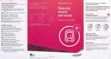
Pamphlet, Public Transport Victoria (PTV), "Special event services", 2019
... , colour detailing the service changes, the routes affected... the service changes, the routes affected, providing a map and how ...1 pamphlet or hanging notice to around tram handrails, cut out advised of the changes to services due to 2019/2020 New Year's Eve . Laminated card. .2 - pamphlet - 4 fold DL, colour detailing the service changes, the routes affected, providing a map and how to get to the fireworks. 2 copies of each held.trams, tramways, notices and information, special event -
 Melbourne Tram Museum
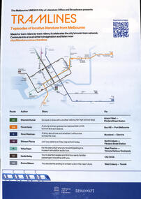
Poster - 7 episodes of tram stories, City of Melbourne, "Tramlines", 2023
... Emma Gibson route 58 Includes a map of the central city tram... Gibson route 58 Includes a map of the central city tram lines ...Poster published as part of promotion of "7 episodes of locative literature from Melbourne" featuring various stories of Melbourne tram routes from the riders perspective; Shamini Kumar route 59 Fiona Hardy route 109 Nova Weetman route 6 Shivaun Piozza - route 19 Vidya Rajan route 11 Nadia Bailey route 35 Emma Gibson route 58 Includes a map of the central city tram lines. Sponsored by the City of Melbourne and Broadwave. Oct. 2023Demonstrates a series of stories evolving around Melbourne tram routes and life.Poster - A2 printed in full colour.tramways, stories, melbourne, podcasts, tram routes -
 Melbourne Tram Museum
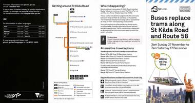
Pamphlet, Public Transport Victoria (PTV), Buses replace trams along St Kilda Road and Route 58, Oct. 2022
... . Includes maps, alternative routes. Issued by Public Transport... maps, alternative routes. Issued by Public Transport Victoria ...Pamphlet - Buses replace trams along St Kilda Road and Route 58 - issued for the track relocation at Domain Junction / Anzac station during the period 27-11-2022 to 17-12-2022. Actual work took a day longer due to weather. Similar pamphlets would have been issued for other routes that used St Kilda Road. Includes maps, alternative routes. Issued by Public Transport Victoria. Part of the Metro tunnel works.Yields information about the reconstruction of Domain Junction for the future Anzac station.Pamphlet - four fold DL - full colour on semi gloss paper. Two copies held.tramways, route 58, anzac station, domain interchange, track work, bus replacement -
 Melbourne Tram Museum
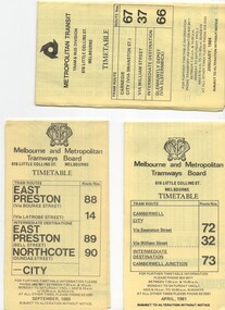
Ephemera - Timetable/s, Melbourne & Metropolitan Tramways Board (MMTB), "MMTB Tram Timetables", 1977 to 1978
... information on tram times at specific time points, route map, sections... on tram times at specific time points, route map, sections ...Set of 6 MMTB Tram timetables, folded sheets, 8 sections, providing timetables for specific routes, day of week giving information on tram times at specific time points, route map, sections and fares and organisation address - 616 Little Collins St. Melbourne. All printed on yellow paper. 1. - Route 67, 37 and 66 - Carnegie - City via Swanston St (67), via William St (37) and Glenhuntly Depot (66) - dated Oct. 1978. .2 - Route 69 - Kew Cotham Road - St Kilda Beach dated Dec. 1978 .3 - Route 70, 71 and 76 - Wattle Park - Batman Ave, Arraign Road (Route 71) and Camberwell Depot (Route 76), dated May 1978 .4 - Route 72, 32 and 73 - Camberwell City via Swanston St (72), via William St (32) and Camberwell Junction (73) dated Sept, 1978. .5 - Route 82 - Moonee Ponds - Footscray - Highpoint West - dated Sept. 1977 .6 - Route 88, 14, 89 and 90, 96, 95 and 97 - East Preston via Bourke St (88), via Latrobe St (14), East Preston Bell St (89) and Northcote Dundas St (90) to the city and East Brunswick (96), Exhibition (95) and North Fitzroy (Park St), dated May 1978. .7 - Routes 48, 24, 40, 41, 29, 74, 76. 28 - July 1978 .8 - ditto - Weekends, July 1978, printed on green paper. .9 - Bus routes 284 (East Kew - Doncaster North) and 270 (East Kew - Shoppingtown) - dated August 1978trams, tramways, mmtb, timetables, melbourne, fares, route 14, route 32, route 37, route 66, route 67, route 69, route 70, route 71, route 72, route 73, route 76, route 82, route 88, route 89, route 90, route 95, route 96, route 97, route 48, route 24, route 40, route 41, route 29, route 74, route 76, route 28, route 284, route 270 -
 Ballarat Tramway Museum
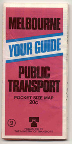
Map, Ministry of Transport, "Melbourne - Your Guide - Public Transport, No. 11, 1980", 1980
... maps of tram routes and train lines or services. Includes... in greater Melbourne and on rear, route numbers and line maps of tram ...Pocket size - folded - public transport map of Melbourne, printed in colour on heavy paper, showing public transport services in greater Melbourne and on rear, route numbers and line maps of tram routes and train lines or services. Includes private bus routes. Printed 1980 by Government Printer. Issue No. 11. Image added 20-12-2016.On front cover, in biro, a telephone number "617 0900"trams, tramways, melbourne, map, routes -
 Ballarat Tramway Museum
Map, Ministry of Transport, "Melbourne Public Transport Map" - "No. 9", 1979
... area shown in detail. On the rear, route numbers and line maps... Routes Pocket size - folded - public transport map of Melbourne ...Pocket size - folded - public transport map of Melbourne, printed in colour on paper, showing public transport services in greater Melbourne and an index of localities. The Central zone area shown in detail. On the rear, route numbers and line maps of tram routes and train lines or services. Includes private bus routes. Printed for the Ministry of Transport. Issue No. 9. Dated 1979.trams, tramways, melbourne, map, routes -
 Bendigo Historical Society Inc.
Map - GUIDE MAP OF BENDIGO & EAGLEHAWK, Late 1920's
... , Lithographer. Map shows tramways & bus routes. Map shows Agricultural... tramways & bus routes. Map shows Agricultural Showgrounds located ...Map. Guide Map of Bendigo & Eaglehawk. Light brown coloured booklet containing folded map of Bendigo and Eaglehawk. Outer cover is printed in blue and red ink and states - With compliments of J H Curnow & Son, Auctioneers, Real Estate Agents, Farm & Dairy Produce Merchants, Bendigo. Printed by J B Young, Lithographer. Map shows tramways & bus routes. Map shows Agricultural Showgrounds located between Park Street, Water Street, Barnard Street and Bridge Lane. Also shows Acclimitization Reserve located behind The Botanical Gardens at White Hills. Shows the location of Sailors Gully, Peg-Leg Gully, Jobs Gully, California Gully, Long Gully, Ironbark Gully, Golden Gully, Poverty Gully, Sheepshead Gully, Charcoal Gully, Eaglehawk Creek, Bendigo Creek and Back Creek. Contains interesting facts about Bendigo - Area 7,900 acres. Population - 26,000. First Council elected - 1855. Proclaimed a Borough - 1863. Proclaimed a City - 1871. Gold Rush broke out - 1851. For first 10 years gold yield averaged 8,600 ozs. per week . Total gold yield to 1923 - 572 tons valued at 82,000,000 pounds. Deepest mines - Victoria Quartz 4,614 ft., New Chum Railway 4,318 ft. 13 mines over 3.000 ft. deep. 53 mines over 2,000 ft. deep. Sewering of City commenced 1922, all principal buildings now sewered. Map printed by Arnall & Jackson, General Printers, Stationers & Engravers, 476 Collins Street. Map displays advertisement for J H Curnow & Son, Bendigo's leading Auctioneer and Estate Agents, Mitchell & Queen Sts. Bendigo. Map Scale 20 chs. = 1 in.cottage, miners, guide map of bendigo and eaglehawk -
 Melbourne Tram Museum
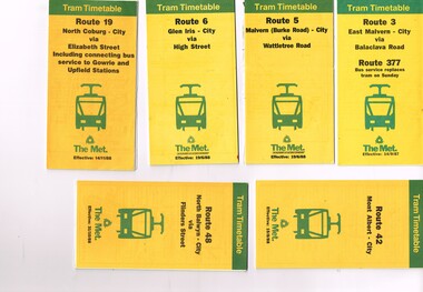
Ephemera - Timetable, The Met, Set of 12 Tram Timetables, produced by The Met, 1987 - 1989
... sheet, giving a route map, description, notes, time points..., multi fold horizontal sheet, giving a route map, description ...Set of 12 Tram Timetables, produced by The Met for various routes, yellow cover with a green top band, multi fold horizontal sheet, giving a route map, description, notes, time points, information contact details and types of tickets (Neighbourhood and Travelcards) and where they could be purchased. .1 - Route 3 - East Malvern - City via Balaclava Road - replaced by bus 377 on Sundays - dated 14/9/1987 .2 - Route 5 - Malvern Burke Road - City via Wattletree Road - 19/6/1988 .3 - Route 6 - Glen Iris - City via High St - 19/6/1988 .4 - Route 19 - North Coburg - City via Elizabeth St including connecting bus service to Gowrie and Upfield stations - 14/11/1988 .5 - Route 42 - Mont Albert - City - 15/8/1988 .6 - Route 48 - North Balwyn - City via Flinders St - 31/10/1988 .7 - Route 55 - West Coburg - Domain Interchange via William St - 11/2/1987 .8 - Route 57 - West Maribyrnong - City via North Melbourne - Route 357 bus replaces tram on Sunday - 27/8/1989 .9 - Route 59 - Airport West - City via Essendon - 27/8/1989 .10 - Route 64 - East Brighton - City via Hawthorn Road - 14/9/1987 .11- Route 70 - Wattle Park (Elgar Road) Princes Bridge via Swan St - 31/10/1988 .12 - Route 86 - Bundoora - City via West Preston - 15/8/1988 Full Image of .4 added 9/4/17 following a query about route 19 timetables - see image i5.trams, tramways, timetables, tickets, tram services, route 3, route 5, route 6, route 19, route 42, route 48, route 55, route 57, route 59, route 64, route 70, route 86 -
 Melbourne Tram Museum
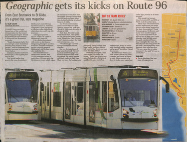
Newspaper, The Age, "Geographic gets its kicks on Route 96", Jan. 2010
... . Includes a map of the route, photo of trams 5012 and 5001. Gives.... Includes a map of the route, photo of trams 5012 and 5001. Gives ...Newspaper clipping from The Age, late Jan 2010, titled "Geographic gets its kicks on Route 96" following the publication of the January 2010 issue of National Geographic featuring Route 96. Includes a map of the route, photo of trams 5012 and 5001. Gives a background history, operation, quotes Daniel Bowen of the PTUA. Has a list of the top 10 tram rides identified by the magazine.trams, tramways, route 96, tramways, melbourne, tram 5001, tram 5012 -
 Ballarat Tramway Museum
Map, Ministry of Transport and The Met, "Public Transport Map of Melbourne" - "Effective August 1988", 1988
... maps of tram routes, train lines, outer metropolitan services... Routes Nil Map - Pocket size - folded - public transport map ...Map - Pocket size - folded - public transport map of Melbourne, printed in colour on art paper, showing public transport services in greater Melbourne, an index of localities. The City Saver area shown in detail. On the rear, route numbers, line maps of tram routes, train lines, outer metropolitan services, ticketing information, Transport Neighbourhoods, . Shows the St Kilda and Port Melbourne light rail lines. Price $2. Shows "The Met" logo. On front under The Met logo and above the scale bar is "Effective 1/7/1988". Niltrams, tramways, melbourne, map, routes -
 Melbourne Tram Museum
Map, The Met, "Public Transport Map of Melbourne" - "Effective August 1988", 1988
... maps of tram routes, train lines, outer metropolitan services... Trams tramways Melbourne Map Routes In ink in top left hand ...Map - Pocket size - folded - public transport map of Melbourne, printed in colour on art paper, showing public transport services in greater Melbourne, an index of localities. The City Saver area shown in detail. On the rear, route numbers, line maps of tram routes, train lines, outer metropolitan services, ticketing information, Transport Neighbourhoods, . Shows the St Kilda and Port Melbourne light rail lines. Price $2. Shows "The Met" logo. On front under The Met logo and above the scale bar is "Effective 1/7/1988".In ink in top left hand corner, "11" in a circle.trams, tramways, melbourne, map, routes -
 Melbourne Tram Museum
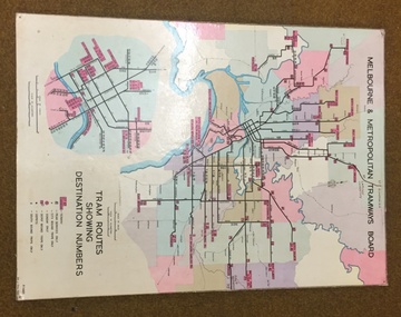
Map, Melbourne & Metropolitan Tramways Board, Del J. Chau, "Tram Routes showing destination numbers", 1972
... Titled "Tram Routes showing destination numbers". Map... Titled "Tram Routes showing destination numbers". Map dated 1972 ...Titled "Tram Routes showing destination numbers". Map dated 1972, showing routes with route numbers, including short working, names of main destinations, roads, railway stations and rail lines, municipalities, rivers, scales, city section in detail, depots and Sunday only services. In bottom right hand corner has number P.14431, Del J. Chau 1972. The original has been altered to show the Bundoora, La Trobe University and East Burwood lines and the change to Airport West. Type of map that was placed on the rear of the driver's doors of a W Class tramcar.Demonstrates a MMTB produced map used in trramcars.Full colour map or poster printed on heavy cardboard.trams, tramways, mmtb, map, routes -
 Melbourne Tram Museum
Document - Timetable/s, Melbourne & Metropolitan Tramways Board (MMTB), "MMTB Tram Timetables", 1980 - 1984
... information on tram times at specific time points, route map, sections... time points, route map, sections and fares and organisation ...Set of 13 MMTB Tram timetables, folded sheets, 10 sections, providing timetables for specific routes, day of week giving information on tram times at specific time points, route map, sections and fares and organisation address - 616 Little Collins St. Melbourne. .1 - Route 72, 32 and 73 - Camberwell City via Swanston St (72), via William St (32) and Camberwell Junction (73) printed on yellow paper, dated April 1981 .2 - Route 88, 14, 89 and 90 - East Preston via Bourke St (88), via Latrobe St (14), East Preston Bell St (89) and Northcote Dundas St (90) to the city, printed on yellow paper, dated September 1980. .3 - Route 67, 37 and 66 - Carnegie - City via Swanston St (67), via William St (37) and Glenhuntly Depot (66) - printed on yellow paper, dated Jan. 1984 -has the Metropolitan Transit Logo. .4 - Route 70, 71 and 76 - Wattle Park - Nov 1979 .5 - Route 77, 78 and 79 - Prahran - City, Prahran - North Richmond - Nov 1979 .6 - Route 82 and 223 - Footscray - Moonee Ponds - tram and bus - Jan 1981 .7 - Route 1, 2, 4 - South Melbourne Beach - Feb 1981 .8 - Route 5 and 35 - Malvern - April 1981 .9 - route 70, 71, 76 - Wattle Park - April 1981 .10 - Route 15, 16, 53 and 55 - St Kilda Beach - Feb 1981 .11 - Route 6, 36. 7 - Glen Iris - July 1981 .12 - Route 59, 49, 51, 52, 82 - Essendon Airport March 1982 .13 - Route 48, 24, 40, 41, 29 North Balwyn - March 1982trams, tramways, mmtb, timetables, melbourne, fares, route 1, route 2, route 4, route 5, route 6, route 7, route 14, route 15, route 16, route 24, route 29, route 32, route 35, route 36, route 37, route 40, route 41, route 48, route 49, route 51, route 52, route 53, route 55, route 59, route 66, route 67, route 70, route 71, route 72, route 73, route 76, route 77, route 78, route 79, route 81, route 82, route 88, route 89, route 90, route 223