Showing 703 items
matching sa
-
 Tatura Irrigation & Wartime Camps Museum
Folder - autobiography, Bert Whitmore, 14 July 1989
an insight into the history and events of camp 14 as narrated by 90 year old Bert Whitmore.A clear plastic cover with a dark blue margin with white strip on which is written "Loveday internment camp 14 - Bert Whitmores Memoirs". The front page has a plan of internment camp 14.Loveday internment camp 14 - Bert Whitmores Memoirsloveday, south australia, bert whitmore, internee memoirs, camp 14 -
Tatura Irrigation & Wartime Camps Museum
Book, The Smith Brothers and The Stump Jump Plough, 1986
Written to commemorate Centenary of stump jump plough, 1876-1976Grey cover, red lettering, white outline of plough.stump jump plough, agricultural equipment, farming equipment -
 Yarrawonga and Mulwala Pioneer Museum
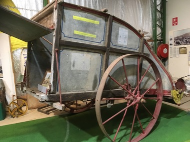
Stripper, The Stripper, 1843
The Stripper was invented by John Ridley in 1843, while trying to overcome harvest labour shortage. In the early ays of Colonial South Australia a labour force was essential to harvest the wheat crop quickly before the grain shook out and fell to the ground. The stripper solved this problem, as t could strip 10 acres [4 hectares], handling approx. 180 bushels [5 tonnes] per day. This replaced 14 men using scythes.Strippers were used in this area between 1870's to the early 1900's.Then the Stripper Harvestors took over this processprinciple of the stripper----The wheat heads were knocked off the straw by a fat revolving beater ,and the grain, mixed with the husks and short straw, was propelled to the rear tin box. When the box became full, the contents were emptied into a winnower for cleaning. Recorded as Mitchell Stripper -
 Unions Ballarat
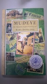
Mudeye: An Australian boyhood and beyond, Dowling, Bary, 1995
Autobiographical and historical book, starting around the time of the Second World War. Explores family history, profiles Ballarat and war time issues. Local (Ballarat) history.Paperback; book; 266 pages. Front cover: green background; old photos and newspaper scraps; title and author in black lettering; sticker - NSW premier's literary awards 1996 shortlisted. Back cover: green background; old photos and newspaper scraps; black lettering; excerpts from reviews.None.ballarat trades hall, ballarat trades and labour council, history - ballarat, autobiography - bary dowling, war - world war ii, history - family, ballarat -
 Beechworth Honey Archive
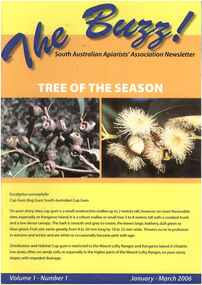
Publication, The Buzz!: the South Australian Apiarists' Association newsletter, 2006-2011
buzz, south, australian, apiarists', association, newsletter -
 Beechworth Honey Archive
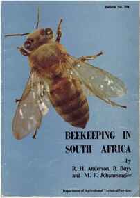
Publication, Beekeeping in South Africa. (Anderson, R. H., Buys, B and Johannsmeier, M. F.). Pretoria, 1983, 1983
207 pages, illustrated.publication, book, beekeeping, south, africa, anderson, buys, johannsmeier, beechworth honey -
 Bendigo Military Museum
Photograph - 4th Field Survey Squadron deployed on Operation NERIGHT, Queensland & Northern Territory, 1989
This is a set of 19 photographs taken in 1989 during 4th Field Survey Squadron’s deployment on Operation NERIGHT 89 in Queensland and the Northern Territory. It was a two-part operation in 1989 with work conducted in the areas of Camooweal and Weipa. Part 1 was the field completion of topographic maps conducted near Camooweal QLD, along the Barkley Highway on the border between NT and QLD, from the 12th of September to the 20th of October 1989. A Bell Kiowa LOH helicopter from 162 Recce Sqn supported topographic field completion. Operation NERIGHT 89 Part 2 was the acquisition of mapping control by GPS field parties utilising Texas Instruments TI4100 Global Positioning System receivers around Weipa on Cape York Peninsula from the 22nd of September to the 22nd of October 1989. Part 2 Two Bell UH-1H Iroquois helicopters from RAAF’s 35 Squadron were principally used to deploy GPS field parties. Identification photography of control points was taken by air camera operators in AAAvn Pilatus Porter aircraft from 173 Gen Spt Sqn fitted with an RC10 aerial camera. The two parts of the operation were conducted concurrently. This is a set of 19 photographs taken in 1989 during 4th Field Survey Squadron’s deployment on Operation Neright in Queensland & the Northern Territory. The colour photographs are on 35mm negative film and are part of the Army Survey Regiment’s Collection. The photographs were scanned at 96 dpi. .1) to .3) - Photo, colour, 1989. En-route to areas of survey operations. .4) to .5) - Photo, colour, 1989. Unidentified personnel relax next to river/waterhole. .6) - Photo, colour, 1989. Two Bell UH-1H Iroquois helicopters from RAAF’s 35 SQN utilised in the movement of GPS parties. .7) to .9) - Photo, colour, 1989. Unidentified soldier practices repelling from a UH1H Iroquois helicopter. .10) - Photo, colour, 1989. Inside the cockpit of a UH1H Iroquois helicopter. .11) - Photo, colour, 1989. Field Party camp with GPS equipment in foreground. Unidentified soldier prepares a meal. .12) - Photo, colour, 1989. GPS antenna plumbed over a survey ground mark. Witness post on left. .13) & .14) - Photo, colour, 1989. Unknown Cape York Peninsula beaches. .15) & .16) - Photo, colour, 1989. Dramatic fire next to base camp. .17) - Photo, colour, 1989. Aboriginal rock art at unknown location. .18) - Photo, colour, 1989. Aboriginal rock art at unknown location. L to R: unidentified, SPR Andrew Quin. .19) - Photo, colour, 1989. Aboriginal rock art at unknown location. LT Chris Topovsek..1P to .19P – There are no personnel identified. ‘1989 OP NERIGHT’ annotated on negative sleeve.royal australian survey corps, rasvy, 4 fd svy sqn, op neright 89 -
 Bendigo Military Museum
Photograph - 4th Field Survey Squadron – Operation ARIGHT 93, Queensland, 1993
This is a set of 42 photographs taken during 4th Field Survey Squadron’s deployment on Operation ARIGHT 93 in North Queensland from the 30th of August to the 8th of October 1993. The Survey Field Completion area of operations was Weipa near the top end of the Cape York Peninsula. Survey parties conducted field checking of topographic maps covering Bamaga, Heathlands, Weipa, Lockhart River and Strathgordon in Perentie 110 Series Survey variant FFR Land Rovers. Hand-held Trimble and Magellan GPS receivers were used to assist with navigation and to position remote isolated features. Three Bell Kiowa LOH helicopters provided by 162 Recce Sqn supported field checking operations. Supplementary and Vital Asset Protection photography was taken by air camera operators in AAAvn Nomad aircraft from 173 Survl Sqn fitted with an RC10 aerial camera.This is a set of 42 photographs taken in 1993 durin8g 4th Field Survey Squadron’s deployment on Operation ARIGHT in North Queensland. The colour photographs are on 35mm negative film and are part of the Army Survey Regiment’s Collection. The photographs were scanned at 96 dpi. .1) - Photo, colour, 1993. Survey party in Perentie 110 Series Land Rover navigates through Cape York Peninsula sand hills. .2) - Photo, colour, 1993. Cape York Peninsula sand hills. .3) - Photo, colour, 1993. Cape York Peninsula Island. .4) - Photo, colour, 1993. Survey party in Perentie 110 Series Land Rover enters a Cape York Peninsula beach. .5) - Photo, colour, 1993. SPR Kim Baker takes a break on a Cape York Peninsula beach. .6) - Photo, colour, 1993. L to R: MAJ Andy Cordova (USA Exchange) from the Army Survey Regiment and unidentified civilians. .7) to .14) - Photo, colour, 1993. Cape York Peninsula topography. .15) - Photo, colour, 1993. Unidentified surveyor in Bell Kiowa LOH helicopter. .16) - Photo, colour, 1993. Bell Kiowa LOH helicopter circles base camp. .17) to .18) - Photo, colour, 1993. Cape York Peninsula topography. .19) - Photo, colour, 1993. Vehicle convoy taking a break. L to R: LT John Bath (Detachment OC), unidentified (x2), SPR Chris Pearse. .20) - Photo, colour, 1993. Vehicle convoy taking a break. .21) - Photo, colour, 1993. Vehicle convoy ready to go. SPR Chris Pearse. .22) - Photo, colour, 1993. Vehicle convoy on the move. .23) - Photo, colour, 1993. Cape York Peninsula topography. .24) - Photo, colour, 1993. Unidentified personnel. .25) - Photo, colour, 1993. SGT Neale ‘Tex’ Houston. .26) - Photo, colour, 1993. Ground below a Bell Kiowa LOH helicopter .27) - Photo, colour, 1993. L to R: SPR Mark Sinderberry and CPL Stuart Adrain in a Bell Kiowa LOH helicopter. .28) & .29) - Photo, colour, 1993. Ground below a Bell Kiowa LOH helicopter. .30) - Photo, colour, 1993. Base camp viewed from a Bell Kiowa LOH helicopter. .31) - Photo, colour, 1993. Cape York Peninsula topography in recovery after burn-off. .32) & .33) - Photo, colour, 1993. SPR Kim Baker contemplates crossing this bridge in his Land Rover. .34) - Photo, colour, 1993. SPR Kim Baker takes a break next to a billabong. .35) - Photo, colour, 1993. Survey party in Perentie 110 Series Land Rover crosses a creek. .36) - Photo, colour, 1993. Cape York Peninsula bush fire in distance. .37) - Photo, colour, 1993. Survey party in Perentie 110 Series Land Rover traverses a sand hill. .38) - Photo, colour, 1993. SPR Kim Baker. .39) - Photo, colour, 1993. Cape York Peninsula bush fire. .40) - Photo, colour, 1993. Cape York Peninsula topography. .41) & .42) - Photo, colour, 1993. Cape York Peninsula sand hills..1P to .42P – There are no personnel identified. ‘1993 OP ARIGHT’ annotated on negative sleeve.royal australian survey corps, rasvy, 4 fd svy sqn, op aright 93 -
 Bendigo Military Museum
Photograph - 4th Field Survey Squadron – Operation NERVOSE 85 Field Phase, Northern Territory, 1985
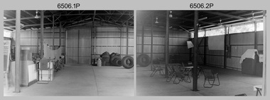
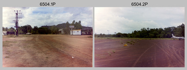
This is a set of 16 photographs taken in 1985* during 4th Field Survey Squadron’s deployment on Operation NERVOSE 85 in the Northern Territory. Operation NERVOSE 85 was mounted by 4 Fd Svy Sqn in the EAST ARNHEM, VICTORIA RIVER DOWNS AND DALY WATERS areas from 26 May to 18 Sep 85. The aim of Operation NERVOSE 85 was to finalise the horizontal and vertical control for mapping at a scale of 1:50,000, to field check 40x 1:50,000 preliminary maps and to obtain mapping photography in support of the RAAF TINDAL redevelopment project. *Note –These photos were most likely taken in 1985, contrary to the ‘1987’ date annotated on the negative sleeves. The Op NERVOSE 85 Project Report available on RASVY’s web site lists a nominal roll of personnel. Photos of 4 Fd Svy Sqn taken in 1985 and 1987 provide names of posted personnel. Several personnel identified in these photos were posted to 4 Fd Svy Sqn in 1985, not in 1987. See items 6504.13P, 6505.28P and 6507.20P for more photos taken prior to and during Operation NERVOSE 1985. This is a set of 16 photographs taken in 1985 during 4th Field Survey Squadron’s deployment on Operation Nervose in the Northern Territory. The black & white photographs are on 35mm negative film and are part of the Army Survey Regiment’s Collection. The photographs were scanned at 96 dpi. ..1) & .2) - Photo, black & white, 1985. Q-store and OPS Room. .3) & .4) - Photo, black & white, 1985. Base Camp at unknown location. .5) - Photo, black & white, 1985. Personnel spectate during a social cricket match. L to R on left: CPL Andy Lucas, unidentified (x3). L to R on right: unidentified (x4), LTCOL Kevin Murphy – SO1 Svy HQ FF Comd, unidentified, SSGT Barry Lutwyche OAM (closest to camera). .6) - Photo, black & white, 1985. Personnel spectate during a social cricket match. L to R on left: unidentified (x2). L to R on right: unidentified (x3), LCPL Chris ‘Charlie’ Brown (standing up), SSGT Barry Lutwyche OAM (closest to camera), LTCOL Kevin Murphy – SO1 Svy HQ FF Comd. .7) - Photo, black & white, 1985. CPL Andy Lucas plans an exit strategy from the latrine. .8) to .10) - Photo, black & white, 1985. Social cricket match action. .11) to .14) - Photo, black & white, 1985. LCPL Chris ‘Charlie’ Brown operates a second-generation Transit Doppler satellite Magnavox MX-1502 Satellite Surveyor Geoceiver. .15) to .16) - Photo, black & white, 1985. LCPL Steve McGuiness sets up a Geoceiver antenna..1P to .16P – There are no personnel identified. ‘1987 OP NERVOSE VICTORIA RIVER DOWNS AND DALY WATERS.’ annotated on negative sleeve.royal australian survey corps, rasvy, 4 fd svy sqn, op nervose 85 -
 Bendigo Military Museum
Photograph - 4th Field Survey Squadron – Operation NERVOSE 85 Field Phase Oblique Photos, NT, 1985
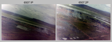
This is a set of 20 oblique aerial photographs taken during the field phase of 4th Field Survey Squadron’s Operation NERVOSE 85 project in the Northern Territory in 1985. Operation NERVOSE 85 was mounted by 4 Fd Svy Sqn in the EAST ARNHEM, VICTORIA RIVER DOWNS AND DALY WATERS areas of the Northern Territory from 26 May to 18 Sep 85. The aim of Operation NERVOSE 85 was to finalise the horizontal and vertical control for mapping at a scale of 1:50,000, to field check 40x 1:50,000 preliminary maps and to obtain mapping photography in support of the RAAF TINDAL redevelopment project. *Note –These photos were most likely taken in 1985, contrary to the ‘1987’ date annotated on the negative sleeves. The Op NERVOSE 85 Project Report available on RASVY’s web site lists a nominal roll of personnel. Photos of 4 Fd Svy Sqn taken in 1985 and 1987 provide names of posted personnel. Several personnel identified in these photos were posted to 4 Fd Svy Sqn in 1985, not in 1987. See items 6504.13P, 6505.28P and 6506.16P for more photos taken prior to and during Operation NERVOSE 1985. This is a set of 20 oblique aerial photographs taken during the field phase of 4th Field Survey Squadron’s Operation NERVOSE 85 project in the Northern Territory in 1985. The colour photographs on 35mm negative film and are part of the Army Survey Regiment’s Collection. The photographs were scanned at 96 dpi. .1) to .20) - Photo, colour, 1985. Unknown locations..1P to .20P – There are no personnel identified. ‘1987 OP NERVOSE VICTORIA RIVER DOWNS AND DALY WATERS.’ annotated on negative sleeve.royal australian survey corps, rasvy, 4 fd svy sqn, op nervose 85 -
 Bendigo Military Museum
Photograph - 4th Field Survey Squadron – Operation NERVOSE 85 Reconnaissance, Northern Territory, 1985
This is a set of 13 photographs taken in 1985* during reconnaissance of locations in regions of the Northern Territory. Later that year, Operation NERVOSE 85 was mounted by 4 Fd Svy Sqn in the EAST ARNHEM, VICTORIA RIVER DOWNS AND DALY WATERS areas of the Northern Territory from 26 May to 18 Sep 85. The aim of Operation NERVOSE 85 was to finalise the horizontal and vertical control for mapping at a scale of 1:50,000, to field check 40x 1:50,000 preliminary maps and to obtain mapping photography in support of the RAAF TINDAL redevelopment project. *Note –These photos were most likely taken in 1985, contrary to the ‘1987’ date annotated on the negative sleeves. The Op NERVOSE 85 Project Report available on RASVY’s web site lists a nominal roll of personnel. Photos of 4 Fd Svy Sqn taken in 1985 and 1987 provide names of posted personnel. Several personnel identified in these photos were posted to 4 Fd Svy Sqn in 1985, not in 1987.This is a set of 13 photographs taken during 4th Field Survey Squadron’s reconnaissance of Operation NERVOSE 85 locations in the Northern Territory in 1985. The colour photographs are on 35mm negative film and are part of the Army Survey Regiment’s Collection. The photographs were scanned at 96 dpi. .1) to .4) - Photo, colour, 1985. Unknown location in the Northern Territory. .5) - Photo, colour, 1985. Unidentified personnel in the back of a police vehicle. .6P to .12) - Photo, colour, 1985. Unknown location in the Northern Territory. .13) - Photo, colour, 1985. L to R: Possibly MAJ A. Vickers RE - UK Exchange Officer from Army Svy Regt, unidentified officer. .1P to .13P – There are no personnel identified. ‘1987 OP NERVOSE – RECON PHOTOG.’ annotated on negative sleeve.royal australian survey corps, rasvy, 4 fd svy sqn, op nervose 85 -
 Bendigo Military Museum
Photograph - 4th Field Survey Squadron – Operation ARIGHT 91, Queensland, 1991
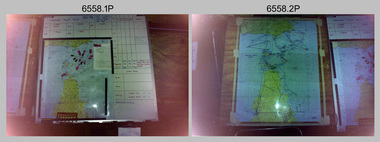
This is a set of 16 photographs taken during 4th Field Survey Squadron’s deployment on Operation ARIGHT 91 in Queensland from the 8th of July to the 5th of September 1991. The area of operations was the top end of the Cape York Peninsula, islands of the Torres Strait and the southern coast of PNG. Field parties utilised Texas Instruments TI4100 Global Positioning System receivers. Concurrent with GPS operations Doppler point positioning observations were carried out by field parties using Magnavox MX 1502 receivers on six of the control points. Two Bell UH-1H Iroquois helicopters from RAAF’s 171 COMD and Liaison Squadron were primarily used to deploy GPS field parties. Identification photography of control points was taken by air camera operators in AAAvn Pilatus Porter aircraft from 173 Gen Spt Sqn fitted with an RC10 aerial camera.This is a set of 16 photographs taken in 1991 during 4th Field Survey Squadron’s deployment on Operation ARIGHT in Queensland. The colour photographs are on 35mm negative film and are part of the Army Survey Regiment’s Collection. The photographs were scanned at 96 dpi. .1) to .3) - Photo, colour, 1991. Area of Operations (AO) coordination maps. .4) - Photo, colour, 1991. GPS acquisition post-processing. L to R: LT Simon Buckpitt, SSGT Steve Winner, WO2 Ken Talbot-Smith. .5) to .6) - Photo, colour, 1991. Base camp unidentified personnel. .7) - Photo, colour, 1991. L to R: OPS WO - WO2 Ken Talbot-Smith, DET SSM WO1 Stevo Hinic. .8) - Photo, colour, 1991. Base camp unidentified personnel. .9) - Photo, colour, 1991. Base camp L to R: unidentified (x2), OPS WO - WO2 Ken Talbot-Smith. .10) - Photo, colour, 1991. Base camp unidentified soldier. .11) - Photo, colour, 1991. Base camp L to R: CPL Andy Love, unidentified, SGT Steve McGuiness. .12) - Photo, colour, 1991. Base camp at Horn Island Army Compound. .13 to .16) - Photo, colour, 1991. Unknown locations in Area of Operations..1P to .16P – There are no personnel identified. ‘1991 OP ARIGHT’ annotated on negative sleeve.royal australian survey corps, rasvy, 4 fd svy sqn, op aright 91 -
 Glenelg Shire Council Cultural Collection
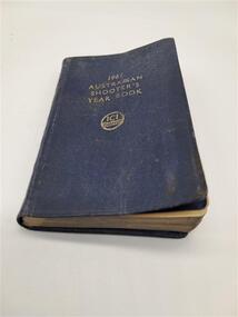
Book, 1961 Australian Shooter's Year Book, 1960 - 61
ICI logo refers to a British company.Small pocket sized book in blue back and front cover. The first half quarter of the book includes information for the shooter, conversion tables. The other three quarters of the book are dedicated to a three day a page 1961 calendar. The calendar is unwritten on.1961 Australian Shooter's Year Book. ICIshooters, book, year book, ici, calendar, diary, ballistics, shot, magnum, patterns, velocity, pellets, cartridge range -
 Bendigo Military Museum
Photograph - 4th Field Survey Squadron – Operation MIZMAZE 92, Kimberley region, Western Australia, 1992
This is a set of 40 photographs taken in 1992 during 4th Field Survey Squadron’s deployment on Operation MIZMAZE 92 in the Kimberley region of Western Australia from the 13th of May to the 14th of July 1992. The area of operations was Wyndham, Halls Creek and Sandfire Flat. It was a two-part operation involving the field completion of topographic maps and the acquisition of mapping control by GPS field parties utilising Texas Instruments TI4100 Global Positioning System receivers. Survey parties conducted field checking of topographic maps and GPS control acquisition in Perentie 110 Series Survey variant FFR Land Rovers. Three Bell Kiowa LOH helicopters provided by 162 Recce Sqn supported field checking and limited deployment of GPS surveys parties. C-l30 Hercules from 36 Sqn supported deployment and extraction of personnel and equipment to and from from the AO. A Cessna 404 Titan Ambassador from Vee-H Aviation was used as the Wild RC10 camera platform for aerial photography acquisition.This is a set of 40 photographs taken in 1992 during 4th Field Survey Squadron’s deployment on Operation MIZMAZE 92 in the Kimberley region of Western Australia. The colour photographs are on 35mm negative film and are part of the Army Survey Regiment’s Collection. The photographs were scanned at 96 dpi. .1) - Photo, colour, 1992. CAPT Craig Hersant. .2) - Photo, colour, 1992. Unidentified officer/soldier. .3) & .4) - Photo, colour, 1992. Aboriginal rock art - Wandjina Gunduran, Donkey Creek. .5) - Photo, colour, 1992. Aboriginal rock art - Track Wandjinas, Donkey Creek. .6) & .7) - Photo, colour, 1992. CAPT Craig Hersant. .8) - Photo, colour, 1992. Kimberley region topography. CPL Glen Weatherell. .9) - Photo, colour, 1992. Unidentified personnel .10) - Photo, colour, 1992. Supermarket at unknown location. .11) to .13) - Photo, colour, 1992. Caravan park at unknown location. .14) - Photo, colour, 1992. Old bridge at Fitzroy Crosssing. .15) & .16) - Photo, colour, 1992. Survey party in Perentie 110 Series Land Rover. .17) & .18) - Photo, colour, 1992. Kimberley region topography. .19) - Photo, colour, 1992. Kimberley region topography. CPL Glen Weatherell. .20) - Photo, colour, 1992. Kimberley region topography, possibly the Bungle Bungles. .21) - Photo, colour, 1992. Kimberley region topography. SGT Frank Downie. .22) - Photo, colour, 1992. Kimberley region topography: the Bungle Bungles. .23) - Photo, colour, 1992. Kimberley region topography: the Bungle Bungles. .24) - Photo, colour, 1992. Kimberley region topography: the Bungle Bungles. SPR Neil Pedler. .25) & .26) - Photo, colour, 1992. Kimberley region topography: the Bungle Bungles. .27) - Photo, colour, 1992. Kimberley region topography. .28) - Photo, colour, 1992. Survey party with Perentie 110 Series Land Rover. .29) - Photo, colour, 1992. Kimberley region topography. .30) - Photo, colour, 1992. Survey party outside Perentie 110 Series Land Rover. .31) & .32) - Photo, colour, 1992. Survey party operating TI4100 GPS Receiver next to Perentie 110 Series Land Rover. SGT Eddie Jacobs. .33) & .34) - Photo, colour, 1992. Survey party operating TI4100 GPS Receiver next to Perentie 110 Series Land Rover. Unidentified surveyor. .35) - Photo, colour, 1992. Kimberley region topography. Hand water pump at well. .36) - Photo, colour, 1992. Survey party in Perentie 110 Series Land Rover. .37) - Photo, colour, 1992. Kimberley region topography. CPL Glen Weatherell. .38) - Photo, colour, 1992. Kimberley region topography viewed from Bell Kiowa LOH helicopter. .39) & .40) - Photo, colour, 1992. Unidentified surveyor field checking a preliminary map in a Bell Kiowa LOH helicopter..1P to .40P – There are no personnel identified. ‘1992 OP MIZMAZE annotated on negative sleeve.royal australian survey corps, rasvy, 4 fd svy sqn, op mizmaze 92 -
University of Melbourne, Burnley Campus Archives
Booklet - Catalogue, Dwarf conifers, Alpine and rock plants, Perennials and dwarf shrubs, 1966-1969
Handbooks for David M. Thomson (Summertown, SA). 2 issuesdavid m. thomson, plants, trees, shrubs, alpines, perennials -
 Tennis Australia
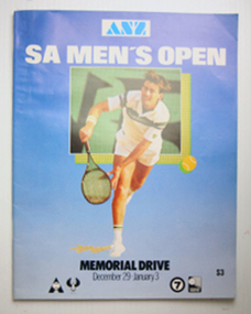
Tournament Programme, 1983
Programme: SA Men's Open 1983 Materials: Paper, Inktennis -
Tatura Irrigation & Wartime Camps Museum
Folder - autobiography, Monash University Publishing, Vittorio Tolaini, 1989
Written during his internment during WW2.Vittorio Tolainis personal account of his internment at Tatura and Loveday SA.vittorio tolaini, internment camp loveday, internment camp 2, internees autobiography -
 Whitehorse Historical Society Inc.
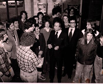
Photograph - B/W photograph x4, Nunawading Youth Group
The opening of Nunawading Youth Group by Don Dunstan who was Premier of SA.youth group, nunawading, 1976 -
 Churchill Island Heritage Precinct
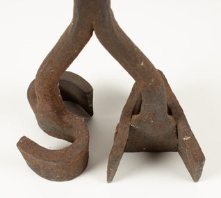
Tool - Branding Iron
TThe Churchill Island collection includes objects from the late 1800s. The collection is presented in sets and series, of which this iron represents the Amess era. This branding iron belonged to Samuel Amess, who owned Churchill Island in the late nineteenth century and used the iron to brand his cattle.Iron handle with initials SA fashioned at base. Surface rust, pitted metal. churchill island, samuel amess, branding iron, cattle -
 Bendigo Historical Society Inc.
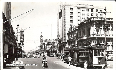
Photograph - BASIL MILLER COLLECTION: KING WILLIAM ST, SOUTH AUSTRALIA - LOOKING SOUTH
BHS CollectionBlack and white photo postcard of 3 trams on King William St, Adelaide, SA. The Savings Bank of SA and Penfolds Wines in background. Written on back in black ink, a letter to his mother from Basil Miller.basil miller, bendigo trams -
 Eltham District Historical Society Inc
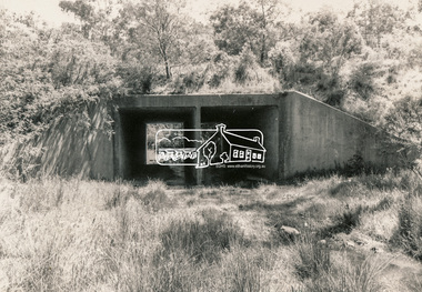
Photograph, Bridge over Smiths Gully Creek, Heidelberg-Kinglake Road, St Andrews, c.1968, 1968c
Looking northwest from Smiths Gully creek at the bridge on Scott Street (Heidelberg-Kinglake Road) just east of the intersection with Burns Street (Kangaroo Ground-St Andrews Road), and the St Andrews MarketBlack and white photograph (x 2)H-KL at KG SAbridge, burns street, heidelberg-kinglake road, infrastructure, kangaroo ground-st andrews road, scott street, shire of eltham, shire of eltham infrastructure, smiths gully creek, st andrews, st andrews market -
 Tatura Irrigation & Wartime Camps Museum
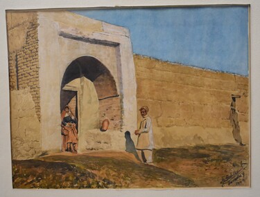
Painting - Painting - Water Colour, Franz Korbler, Darfeingang bei Damghan Iran, 1944 Loveday SA
Painting by Franz Korbler. Architect/artist, born Vienna Austria, arrested Teheran Persia September 12941. Interned Loveday Camp SA and Tatura Camp Victoria 1945-1947.Water colour of brick wall, with stone entrance. Lady standing in doorway, pot to right of her. Man standing centre of picture just in front of the entrance. Blue sky at top of picture.franz korbler -
 Yarrawonga and Mulwala Pioneer Museum
Foot runners starting blocks, 1950’s
Metal flat bar with notched standing bar attached, two foot placement blocks which can be placed in notches along the bar using metal wing bolts. At each end there are two metal spikes with a head and ring attached which can be driven into the gray und. The blocks are solid wood triangular shaped with a slightly curved metal facing where the runners feet are placed. Nelson starting blocks Unley SA -
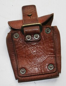
 Trafalgar Holden Museum
Functional object - Ammunition pouch, 1915
Used by soldiers to carry their ammunitionAs manufactured and sold by Holden and FrostTan leather pouch with rear facing cover, Belt loop on rear riveted to the pouch.Holden and Frost CMF SA 1915militay, ammunition pouch -
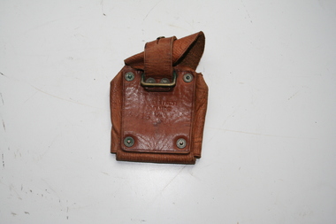
 Trafalgar Holden Museum
Functional object - Bullet Pouch, 1915
Pouch used by Soldiers to carry spare ammunitionAs manufactured by Holden and Frost 1915Tan leather pouch designed to carry rifle ammunition. Leather flap lid and leather strip to attach to brass stud to hold closed. Leather strip inside to hold ammunition in place.Holden and Frost 1915 CMF SAmilitary, ammunition, pouch -
Glenelg Shire Council Cultural Collection
Administrative record - Police Report - larceny, 1913, 11/06/1913
Barry was a police officer stationed at Portland 1969 - 71. Stables were to be demolished. he was instructed to clean them out, and take the contents to the tip. He retained these documents and donated them to the Cultural Collection.Hand written supplementary Police Report of Criminal Offence - larceny, Mt Gambier SA police stationpolice report, mount gambier, theft, larceny -
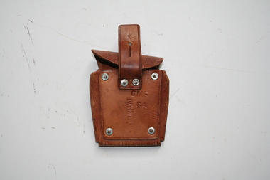
 Trafalgar Holden Museum
Functional object - Ammunition pouch, 1916
As used by soldiers to carry spare ammunitionAs manufactured and sold by Holden and FrostTan leather ammunition pouch, with strap riveted to rear thus making able to attach to bandolier or beltHolden and Frost Adelaide CMF SA /13military, pouch, ammunition -
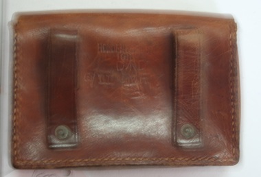 Trafalgar Holden Museum
Accessory - Leather training belt pouch, 1911
Made for Department of Defence 1911Manufactured for Department of Defence by Holden and FrostBrown leather pouch with fold over front cover held shut by peg and key hole slot in cover.Two belt loops on rear. Pouch stitched on all joins.Holden and Frost1911 DOD CMF SA 611military, belt pouch -
 Bendigo Historical Society Inc.
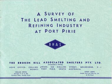
Document - MCCOLL, RANKIN AND STANISTREET COLLECTION: SMELTING, URANIUM, c1955
McColl Rankin & Stanistreet, 4 books: A&B/ A Survey of The Lead Smelting and Refining Industry at Port Pirie published by BHHS, 2 copies. C/Broken Hill Associated Smelters, published by BHAS. D/ Port Pirie Uranium Treatment Plant SA, published by SA Dept Mines.organization, mining, lead smelting smelter uranium port pirie broken hill -
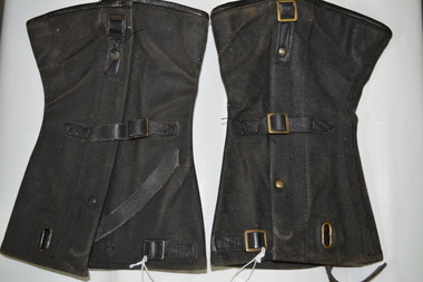 Wangaratta RSL Sub Branch
Uniform - Canvas Gaiters, c1940
During the early stages of the Vietnam conflict, Australian troops wore this pattern of gaiters with Australian Army issued Ankle Boots (AB's) until they were replaced by the General Purpose (GP) boot.This type of gaiters were manufactured in Australia and used by the Australian Army from the mid 1940's until the late 1960's. Each gaiter has a pair of buckles and straps on the side and a buckle and leather strap at the bottom that is fitted under the sole of the boot. On the inside bottom of both gaiters is a single metal tab and double bracket for the tab to slide into.On inside of right leg: ^ FP SA 1968 SIZE 8 R On inside of left leg: ^FP SA 1968 SIZE 8 Lgaiters, military, vietnam conflict