Showing 130 items
matching salisbury house
-
 Bendigo Historical Society Inc.
Map - SALISBURY : COUNTY OF BENDIGO, 1965
Map. Salisbury, County of Bendigo, Pompapiel, Yallook, Yarraberb, Yarrayne, Bullock Creek. Drawn and reproduced at the Department of Lands and Survey, Melbourne. Price $1.00. 1965. By authority A.C. Brooks, Government Printer, Melbourne. (number 28 in map cupboard 1)A.C. Brooks,Government Printer, Melbourne.map, bendigo, salisbury -
Bendigo Historical Society Inc.
Map - POWLETT : COUNTY OF BENDIGO, 2-12-15
Map. Powlett, County of Bendigo, County of Gladstone, Janiember West, Janiember East, Yarrayne, Salisbury West, Kurting, Korong, River Loddon. By Authority Albert J. Mullett, Government Printer, Melbourne. Photographed at the Department of Lands and Survey, Melbourne by W. J. Butson.2-12-15. Price 1/-. (number 119 in map cupboard 1)Albert J. Mullett, Government Printermap, bendigo, powlett -
Bendigo Historical Society Inc.
Map - BENDIGO, 1916
Map. Bendigo, Gunbower, Gladstone, Talbot, Dalhousie, Rodney, Jarklan, Calivil, Hayanmi, Mitiamo, Wanurp, Pannoobamawm, Bamawm, Millewa, Ballendella, Janiember West, Janiember East, Pompapiel, Talambe, Dingee, Milloo, Pannoomilloo, Rochester West, Yarrayne, Salisbury, Yallook, Tandarra, Kamarooka, Warragamba, Diggorra, Minto, Bridgewater, Yarraberb, Neilborough, Whirrakee, Egerton, Elmore, Nolan, Goornong, Bagshot, Huntly, Derby, Leichardt, Nerring, Tarnagulla, Woodstock, Marong, Sandhurst, Wellsford, Bendigo, Axedale, Strathfieldsaye, Eppalock, Kimbolton, Lyell, Sedgwick, Mandurang, Lockwood, Ravenswood, Shelbourne, Laanecoorie. Price 3/-. Smaller map of State of Victoria. Lithographed at the Department of Lands and Survey, Melbourne. 1916. Scale : Two miles to one inch. Map was in book form. (number 62 in map cupboard 1)map, bendigo, bendigo -
Bendigo Historical Society Inc.
Map - BRIDGEWATER : COUNTY OF BENDIGO, 6-10-27
Map. Bridgewater, County of Bendigo, Inglewood, Salisbury, Derby, Leichardt, Yarraberb, Yarrayne, Bullock Creek, Loddon River, Sandhurst and Inglewood Railway. Photo-Lithographed at the Department of Lands and Survey Melbourne by W.J. Butson, 6-10-27. Price 1/-. (number 53 in map cupboard 1)W.J. Butsonmap, bendigo, bridgewater -
Bendigo Historical Society Inc.
Map - YALLOOK : COUNTY OF BENDIGO, 30-1-28
Map. Yallook, County of Bendigo, L4942, Talambe, Tandarra, Neilborough, Yarraberb, Salisbury, Pompapiel. Drawn and reproduced at the Department of Lands and Survey, Melbourne, Victoria. 30-1-28. H.J. Green, Govt. Printer, Melbourne. (number 18 in map cupboard 1)H.J. Green, Govt. Printer.map, bendigo, yallook -
Bendigo Historical Society Inc.
Map - YARRABERB : COUNTY OF BENDIGO, 23-2-15
Map. Yarraberb, County of Bendigo, Salisbury, Yallook, Neilborough, Nerring, Leichardt, Bridgewater. L5373. Photographed at the Department of Lands and Survey, Melbourne by W.J. Butson 23-2-15. Price 1/-.By authority: Albert J. Mullett, Government Printer, Melbourne. (number 16 in map cupboard 1)By authority Albert J. Mullett, Government Printer.map, bendigo, agricultural lands -
Bendigo Historical Society Inc.
Map - YARRABERB : COUNTY OF BENDIGO, 2-3-51
Map. Yarraberb, County of Bendigo, Salisbury, Yallook, Neilborough, Nerring, Leichardt, Bridgewater. L5373. By authority H.J. Green, Govt. Printer,Photo-Lithographed at the Deptartment of Lands and Survey, Melbourne. Price 2/-.2-3-51. (number 15 in map cupboard 1)H.J. Green, Govt. Printermap, bendigo, agricultural lands -
Bendigo Historical Society Inc.
Map - SALISBURY WEST : COUNTY OF BENDIGO, 24-6-24
Map. Salisbury, County of Bendigo, County of Gladstone, Powlett, Yarrayne, Bridgewater, Inglewood, Glenalbyn, Kurting, River Loddon, Bulabul Creek. By authority A.J. Mullett, Government Printer, Melbourne. Photo-Lithographed at the Department of Lands and Survey, Melbourne by W.J. Butson, 24-6-24. Price 1/-. (number 116 in map cupboard 1)A.J. Mullett, Government Printer, Melbourne.map, bendigo, salisbury west -
Bendigo Historical Society Inc.
Map - YALLOOK : COUNTY OF BENDIGO, 1957
Map. Yallook, County of Bendigo, Talambe, Neilborough, Yarraberb, Salisbury, Pompapiel. Drawn and reproduced at the Department of Lands and Survey, Melbourne,1957. Distances shown on the plan are derived from original surveys of varying dates and whilst approximately correct do not necessarily conform to modern standards of accuracy. For survey information application should be made to the central plan office, or to the office of titles. Some ink scibbles appear at the right top of this map. Price 2/-. (number 14 in map cupboard 1)By Authority W.M.Houston, Govt.Printer,Melbourne.map, bendigo, yallook -
Bendigo Historical Society Inc.
Map - SALISBURY WEST : COUNTY OF BENDIGO, 3-3-1944
Map. Salisbury, County of Bendigo, County of Gladstone, Powlett, Yarrayne, Bridgewater, Inglewood, River Loddon, Bullabul Creek, Glenalbyn, Kurting. By Authority H.E. Daw, Government Printer, Melbourne. Drawn and reproduced at the Department of Lands and Survey, Melbourne., 3-3-1944. Price 5/-. (number 94 in map cupboard 1)H.E. Daw, Government Printer, Melbourne.map, bendigo, salisbury west -
 Bendigo Historical Society Inc.
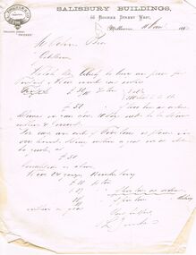
Document - COHN BROTHERS COLLECTION: HANDWRITTEN LETTER DATED 1893
Printed letterhead L Zwicker & Co Salisbury Buildings 66 Bourke Street West, Melbourne dated 11th March 1893. sent to Cohns Bros re quote for purchase of goods, signed L Zwicker.bendigo, industry, cohn bros brewery -
Bendigo Historical Society Inc.
Map - YARRAYNE : COUNTY OF BENDIGO, 6-1-32
Map. Yarrayne, County of Bendigo, Janiember East; Pompapiel, Salisbury, Bridgewater, Salisbury West, Powlett. Photo-Lithographed at the Department of Lands and Survey, Melbourne. Price 2/-. 6-1-32. (number 12 in map cupboard 1)H.J. Green, Government Printermap, bendigo, yarrayne -
Bendigo Historical Society Inc.
Map - YALLOOK : COUNTY OF BENDIGO, 1957
Map. Yallook, County of Bendigo,Talambe, Tandarra, Neilborough, Yarraberb, Salisbury, Pompapiel. Drawn and reproduced at the Department of Lands and Survey, Melbourne.1957. Price 2/-. By authority W.M. Houston, Government Printer. (number 11 in map cupboard 1)W.M Houston, Government Printermap, bendigo, yallook -
Bendigo Historical Society Inc.
Map - SALISBURY : COUNTY OF BENDIGO, 1965
Map. Salisbury, County of Bendigo, Pompapiel, Yarrayne, Yarraberb, Yallook, Bullock Creek. By Authority: A.C. Brooks, Government Printer, Melbourne. Drawn and reproduced at the Department of Lands and Survey, Melbourne.1965. Price $1.00. (number 6 in map cupboard 1)A.C. Brooks, Government Printermap, bendigo, salisbury -
Bendigo Historical Society Inc.
Map - POMPAPIEL : COUNTY OF BENDIGO, 1-10-27
Map. Pompapiel, County of Bendigo, Calivil, Janiember East, Yarrayne, Salisbury, Yallook, Talambe, Judyong Creek, Bullock Creek, Pompapiel Creek, Edeyrn Estate. Photo-Lithographed at the Department of Lands and Survey, Melbourne by W.J. Butson, 1-10-27, Price 1/-. (number 4 in map cupboard 1)W.J. Butson, Government Printermap, bendigo, pompapiel -
 Bendigo Historical Society Inc.
Map - JACK FLYNN COLLECTION: SALISBURY, 1965
Map: Parish of Salisbury, County of Bendigo. Parish plan.By Authority A. C. Brooks Government Printer, Melbourne. Drawn and Reproduced at the Department of Lands and Survey, Melbourne.map, bendigo, parish plan, salisbury -
Bendigo Historical Society Inc.
Map - SALISBURY WEST, 14/10/1943
Map: Salisbury West, County of Gladstone. Parish plan ( number 179 in Map Cupboard 1)map, gladstone, parish plan, salisbury west , county of gladstone -
Bendigo Historical Society Inc.
Map - SALISBURY WEST, 29/01/1878
Map: Salisbury West, County of Gladstone. Parish plan (number 305 in map cupboard 1)map, gladstone, parish plan, salisbury west -
 Robin Boyd Foundation
Slide, Robin Boyd, 1950
... Leading to Hatfield House (Marquess of Salisbury) (Handwritten)... (Handwritten) / Street in Hertfordshire Leading to Hatfield House ...Penleigh Boyd, Robin and Patricia Boyd's son, writes “Prior to 1950 Robin, like most other amateur or hobby photographers, took black and white printed photographs. The oldest slides date from 1950 when Robin and Patricia travelled to Europe on Robin’s Robert Haddon Travelling Scholarship.” In 1948 Robin Boyd was awarded ‘joint first place’ in the Robert Haddon competition for his design of Mildura art gallery. The scholarship helped fund their first overseas trip. Robin and Patricia were passengers on the Greek ship “Cyrenia” departing in May 1950, passing through the Suez Canal and landing in Genoa five weeks later. For six months, they travelled extensively throughout Europe (predominantly driving themselves) - France, Italy, United Kingdom, Sweden, Denmark, Germany, Austria, Switzerland and Spain.Colour slide in a mount. Street in Hatfield, Hertfordshire, leading to Hatfield House, Hatfield, EnglandEngland Street (Handwritten) / Street in Hertfordshire Leading to Hatfield House (Marquess of Salisbury) (Handwritten)haddon travelling scholarship, haddon, robin boyd, slide -
 Whitehorse Historical Society Inc.
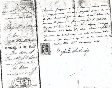
Document, Jobson's Road, 28/12/1895
Part of contract of sale between Elizabeth Salisbury (Vendor) and Eriksson (purchaser) of four acres of land with weatherboard house at Jobson's RoadPart of contract of sale between Elizabeth Salisbury (Vendor) and Eriksson (purchaser) of four acres of land with weatherboard house at Jobson's Road, Blackburn (now Junction Road, Blackburn North), 28 December 1895.Part of contract of sale between Elizabeth Salisbury (Vendor) and Eriksson (purchaser) of four acres of land with weatherboard house at Jobson's Roaderiksson, salisbury, elizabeth, jobson's road, blackburn, junction road, blackburn north, land sales -
 Whitehorse Historical Society Inc.
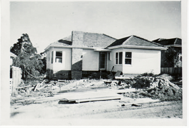
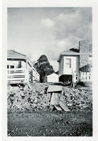
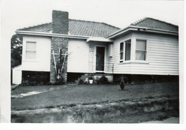
Photograph, Building Turner Home - 27 Salisbury Street, 1956
Collected at a Heritage Week Workshop at Blackburn Library on 5th October 2009.Black & white photograph of the Turner home being built in Salisbury Street Blackburn on 15 April 1956.salisbury avenue blackburn no 27, 1950's house -
 Whitehorse Historical Society Inc.
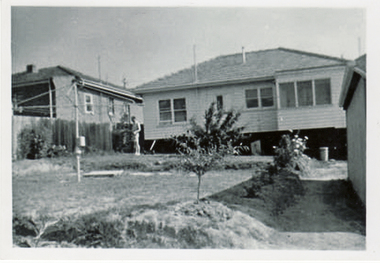
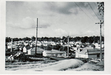
Photograph, Turner Home in Salisbury Ave Blackburn, 1957
Collected at a Heritage Week Workshop at Blackburn Library on 5th October 2009.Black & white photograph Turner home at 26 Salisbury Ave Blackburn showing a series of views of the making of the road in June 1957salisbury avenue blackburn no 27, 1950's house, road making -
 Whitehorse Historical Society Inc.
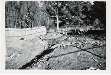
Photograph, Turner Home in Salisbury Ave Blackburn, 1957
Collected at a Heritage Week Workshop at Blackburn Library on 5th October 2009.Black & white photograph Turner home at 26 Salisbury Ave Blackburn showing a view of the back yard - June 1957salisbury avenue blackburn no 27, 1950's house -
 Whitehorse Historical Society Inc.
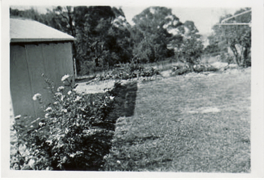
Photograph, Turner Home in Salisbury Ave Blackburn, 1958
Collected at a Heritage Week Workshop at Blackburn Library on 5th October 2009.Black & white photograph Turner home at 27 Salisbury Ave Blackburn showing a view of the back garden in 1958salisbury avenue blackburn no 27, 1950's house -
 Whitehorse Historical Society Inc.
Photograph, Turner Home in Salisbury Ave Blackburn, 1958
Collected at a Heritage Week Workshop at Blackburn Library on 5th October 2009.Black & white photograph Turner home 26 Salisbury Ave Blackburn showing view of back garden looking to the retarding basin.salisbury avenue blackburn no 27, 1950's house, retarding basin -
 Whitehorse Historical Society Inc.
Photograph, Turner Home in Salisbury Ave Blackburn, 1958
Collected at a Heritage Week Workshop at Blackburn Library on 5th October 2009.Black & white photograph Turner home at 27 Salisbury Ave Blackburn showing view of front garden in 1958.salisbury avenue blackburn no 27, 1950's house -
 Whitehorse Historical Society Inc.
Photograph, Turner Home in Salisbury Ave Blackburn, 1957
Collected at a Heritage Week Workshop at Blackburn Library on 5th October 2009.Black & white photograph Turner home at 27 Salisbury Ave Blackburn showing view looking from Middleborough Road to Salisbury Avenue.salisbury avenue blackburn no 27, 1950's house -
 Ballarat Heritage Services
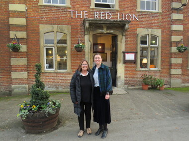
Photograph - Digital photograph, Wayne Phillipson, Peta Knott and Dorothy Wickham at Lacock National Trust Village, United Kingdom, 30/1072016
Lacock was on the main London to Bristol road until the road was re-routed through Chippenham. There are no obvious signs of the 21st century in this National Trust village, except the motor car. It has been run by the National Trust since 1944 and residents are on a lease. The oldest house in the village is King John's Hunting Lodge, parts of which date back to the 13th century. In this village there are buildings from every century since right up until the 18th century. The abbey was founded in 1229 by Ela, Countess of Salisbury. Lacock village and abbey were used as the set in the Harry Potter films.Dorothy Wickham and Peta Knott, formerly of Museums Australia (Vic) currently working as a marine archaeologist in England. Taken at Lacock National Trust Village, United Kingdomdorothy wickham, peta knott, lacock national trust village -
 Ballarat and District Irish Association
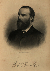
Image, Charles Parnell, c1864, 1864
Parnell was an Irish nationalist and statesman who led the fight for Irish Home Rule in the 1880s. Charles Stewart Parnell was born on 27 June 1846 in County Wicklow into a family of Anglo-Irish Protestant landowners. He studied at Cambridge University and was elected to parliament in 1875 as a member of the Home Rule League (later re-named by Parnell the Irish Parliamentary Party). His abilities soon became evident. In 1878, Parnell became an active opponent of the Irish land laws, believing their reform should be the first step on the road to Home Rule. In 1879, Parnell was elected president of the newly founded National Land League and the following year he visited the United States to gain both funds and support for land reform. In the 1880 election, he supported the Liberal leader William Gladstone, but when Gladstone's Land Act of 1881 fell short of expectations, he joined the opposition. By now he had become the accepted leader of the Irish nationalist movement. Parnell now encouraged boycott as a means of influencing landlords and land agents, and as a result he was sent to jail and the Land League was suppressed. From Kilmainham prison he called on Irish peasants to stop paying rent. In March 1882, he negotiated an agreement with Gladstone - the Kilmainham Treaty - in which he urged his followers to avoid violence. But this peaceful policy was severely challenged by the murder in May 1882 of two senior British officials in Phoenix Park in Dublin by members of an Irish terrorist group. Parnell condemned the murders. In 1886, Parnell joined with the Liberals to defeat Lord Salisbury's Conservative government. Gladstone became prime minister and introduced the first Irish Home Rule Bill. Parnell believed it was flawed but said he was prepared to vote for it. The Bill split the Liberal Party and was defeated in the House of Commons. Gladstone's government fell soon afterwards.(http://www.bbc.co.uk/history/historic_figures/parnell_charles.shtml, accessed 21 January 2014) The Irish National Land League (Irish: Conradh na Talún) was an Irish political organisation of the late 19th century which sought to help poor tenant farmers. Its primary aim was to abolish landlordism in Ireland and enable tenant farmers to own the land they worked on. The period of the Land League's agitation is known as the Land War. Within decades of the league's foundation, through the efforts of William O'Brien and George Wyndham (a descendant of Lord Edward FitzGerald), the 1902 Land Conference produced the Land (Purchase) Act 1903 which allowed Irish tenant farmers buy out their freeholds with UK government loans over 68 years through the Land Commission (an arrangement that has never been possible in Britain itself). For agricultural labourers, D.D. Sheehan and the Irish Land and Labour Association secured their demands from the Liberal government elected in 1905 to pass the Labourers (Ireland) Act 1906, and the Labourers (Ireland) Act 1911, which paid County Councils to build over 40,000 new rural cottages, each on an acre of land. By 1914, 75% of occupiers were buying out their landlords, mostly under the two Acts. In all, under the pre-UK Land Acts over 316,000 tenants purchased their holdings amounting to 15 million acres (61,000 km2) out of a total of 20 million acres (81,000 km2) in the country. Sometimes the holdings were described as "uneconomic", but the overall sense of social justice was undeniable. (http://en.wikipedia.org/wiki/Irish_National_Land_League, accessed 21 January 2014) The Irish National Land League was founded at the Imperial Hotel in Castlebar, the County town of Mayo, on 21 October 1879. At that meeting Charles Stewart Parnell was elected president of the league. Andrew Kettle, Michael Davitt, and Thomas Brennan were appointed as honorary secretaries. This united practically all the different strands of land agitation and tenant rights movements under a single organisation. The two aims of the Land League, as stated in the resolutions adopted in the meeting, were: ...first, to bring out a reduction of rack-rents; second, to facilitate the obtaining of the ownership of the soil by the occupiers. That the object of the League can be best attained by promoting organisation among the tenant-farmers; by defending those who may be threatened with eviction for refusing to pay unjust rents; by facilitating the working of the Bright clauses of the Irish Land Act during the winter; and by obtaining such reforms in the laws relating to land as will enable every tenant to become owner of his holding by paying a fair rent for a limited number of years. Charles Stewart Parnell, John Dillon, Michael Davitt, and others including Cal Lynn then went to America to raise funds for the League with spectacular results. Branches were also set up in Scotland, where the Crofters Party imitated the League and secured a reforming Act in 1886. The government had introduced the first ineffective Land Act in 1870, then the equally inadequate Acts of 1880 and 1881 followed. These established a Land Commission that started to reduce some rents. Parnell together with all of his party lieutenants, including Father Eugene Sheehy known as "the Land League priest", went into a bitter verbal offensive and were imprisoned in October 1881 under the Irish Coercion Act in Kilmainham Jail for "sabotaging the Land Act", from where the No-Rent Manifesto was issued, calling for a national tenant farmer rent strike which was partially followed. Although the League discouraged violence, agrarian crimes increased widely. Typically a rent strike would be followed by evictions by the police, or those tenants paying rent would be subject to a local boycott by League members. Where cases went to court, witnesses would change their stories, resulting in an unworkable legal system. This in turn led on to stronger criminal laws being passed that were described by the League as "Coercion Acts". The bitterness that developed helped Parnell later in his Home Rule campaign. Davitt's views were much more extreme, seeking to nationalise all land, as seen in his famous slogan: "The land of Ireland for the people of Ireland". Parnell aimed to harness the emotive element, but he and his party preferred for tenant farmers to become freeholders on the land they rented, instead of land being vested in "the people".(http://en.wikipedia.org/wiki/Irish_National_Land_League, accessed 21 January 2014)Image of bearded man known as Charles Stewart Parnellballarat irish, parnell, charles parnell, home rule -
 Bendigo Historical Society Inc.
Document - MCCOLL, RANKIN AND STANISTREET COLLECTION: MORROW'S SYNDICATE, 1935
Manilla folder containing correspondence from Robert Irving, Inglewood about his pegging a 3000 acre block for prospecting and mining purposes. Also contains an application for a mining lease known as Morrow's Syndicate, this covers about 50 acres and is a ten year lease. The place of operation is at SalisburyRobert Irvinggold, mining, morrow's syndicate, gold mines, inglewood, robert irving, morrow's syndicate, salisbury