Showing 179 items
matching sandhurst maps
-
 Bendigo Historical Society Inc.
Document - MCCOLL, RANKIN AND STANISTREET COLLECTION: GOLDEN CARSHALTON NO LIABILITY, 1949
... /8/1949. Golden Carshalton N\L Map of Bendigo Sandhurst Lease... 16/8/1949. Golden Carshalton N\L Map of Bendigo Sandhurst ...Documents: Gold Mining Lease No. 11257 FOL.36397 Bendigo 16/8/1949. Golden Carshalton N\L Map of Bendigo Sandhurst Lease No 11257 showing the Carshalton Mines Ltd New Main Shaft, Hansel Mundy Shaft.MCCOLL RANKIN AND STANSISTREETorganization, business, gold mining - legal, mccoll rankin and stansistreet. golden carshalton n\l. mundy shaft. -
 Bendigo Historical Society Inc.
Document - CONNELLY, TATCHELL, DUNLOP COLLECTION: LEGAL PAPERS, 1878 1889
Document. Various legal papers. 1 - 1856? - Petition for Vesting Order in the matter of Diviney Michael, late of Sandhurst. Mentions Hughes Joshua and Freame H S? for Flegg Wm Sandhurst. 2 - Hughes J. Application for Vesting Order. Mentions Doran Joseph Christopher & Diviney. 3 - 1878 - In the matter of the Hope Tribute Mining Company Reg and in the matter of the Mining Companies Act 1891 between the Commercial Bank of Australia Ltd. (Appellant) and the Hope Tribute Mining Company Reg (Respondent). Appeal case. 4 - 1889 - Transfer of Land in Kerang from Ellis Asher (Postmaster) to Victorian Railways Commissioners. Contains map of said land.cottage, miners, connelly, tatchell & dunlop, diviney michael, hughes joshua, freame h s?, flegg wm, doran joseph christopher, hope tribute mining company, commercial bank of australia, ellis asher, victorian railways commissioners -
 Bendigo Historical Society Inc.
Document - OLD TOM LEASE MAP
Hand Drawn map of Old Tom Lease - Parish of Huntly, County of Bendigo, Mining district of Sandhurst.place, land, mining -
 Bendigo Historical Society Inc.
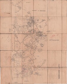
Map - JACK FLYNN COLLECTION: SANDHURST SHEET 6, January 1947
... Map: Parish of Sandhurst Sheet 6. County of Bendigo. Parish..., of Lands and Survey, Melbourne, Victoria. Map: Parish of Sandhurst ...Map: Parish of Sandhurst Sheet 6. County of Bendigo. Parish plan.By Authority J. J. Gourley, Government Printer, Melbourne. Drawn and Reproduced at the Dept, of Lands and Survey, Melbourne, Victoria.map, bendigo, parish plan, sandhurst sheet 6 -
 Bendigo Historical Society Inc.
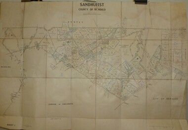
Map - JACK FLYNN COLLECTION: SANDHURST SHEET 2, January 1947
... Map: Parish of Sandhurst Sheet 2, County of Bendigo. Parish..., of Lands and Survey, Melbourne, Victoria. Map: Parish of Sandhurst ...Map: Parish of Sandhurst Sheet 2, County of Bendigo. Parish plan.By Authority J. J. Gourley, Government Printer, Melbourne. Drawn and Reproduced at the Dept, of Lands and Survey, Melbourne, Victoria.map, bendigo, parish plan, sandhurst sheet 2 -
 Bendigo Historical Society Inc.
Map - JACK FLYNN COLLECTION: SANDHURST SHEET 1, January 1947
... Map: Parish of Sandhurst sheet 1, County of Bendigo. Parish... Bendigo parish plan Sandhurst Map: Parish of Sandhurst sheet 1 ...Map: Parish of Sandhurst sheet 1, County of Bendigo. Parish plan.map, bendigo, parish plan, sandhurst -
 Bendigo Historical Society Inc.
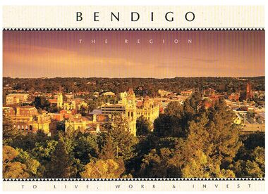
Book - BENDIGO - THE REGION TO LIVE, WORK & INVEST
Pale yellow 12 page book titled 'Bendigo the Region to Live Work & Invest'. On the front cover is a scenic view of Bendigo and on the back cover a picture of some quartz and gold nuggets on a green background. Sections in the book are: Live Work & Invest, Lifestyle, Access, Community, Infrastructure, Labour Force, Business, Opportunity, Successes and Information. Each page has a colour picture, they are:- Hargreaves Mall, Eaglehawk Golf Course, Map of Victoria, La Trobe University, Big Hill, Regional Office Department of Planning & Development, Sandhurst Farms, Construction Activity, Products of the Region, Dr. Ian Macbean, Mr Evan Jones and the Capital Theatre with information on each.book, bendigo, bendigo, bendigo - the region to live, work & invest, bendigo regional development board, dr ian macbean, mr evan jones, kate mildren, richard gibbs, express printers, hargreaves mall, eaglehawk golf course, map of victoria, la trobe university, big hill, regional office department of planning & development, sandhurst farms, construction activity, products of the region, capital theatre -
 Bendigo Historical Society Inc.
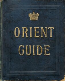
Book - BOOK: ORIENT GUIDE ORIENT LINE OF ROYAL MAIL STEAMSHIPS
Green coloured hardbound Book / gold lettering -Orient Guide /-front and back inside covers show - Orient line of Royal Mail Steamships Henry Jones & co Agents for Orient Line , View Point , Sandhurst , Orient Line of Royal Mail Steamships' / Title page shows 'Orient Line Guide -Chapters for Travellers by sea and land , Illustrated . The third Edition, Re- written, with maps and plans. Edited for the Managers of the Line by W.J.Loftie, B.A., F.S.A., Author of 'A History of London ‘, 'Windsor ' 'Authorised guide to the Tower 'Etc. Etc. . . . Price 2/6 London : Sampson Low , Marston , Searle , & Rivington , Limited , St. Dunstan's House , Fetter lane , Edward Stanford , 26 , & 27 Cockspur St . S.W. 1888 Entered at Stationers Hall / this page also has a rubber stamp ' Eaglehawk Public Library / first page of chapter 1 shows 'With compliments of Henry Jones & Co , View point Sandhurst / contents include a list of Orient Line Steam ships , illustrations and ships 'plans ,maps , advertsorganization, business, -orient guide / orient line of royal mail steamships henry jones & co agents for orient line , view point , sandhurst , orient line of royal mail steamships' / w.j.loftie , b.a., f.s.a. , author of 'a history of london ' / sampson low , marston , searle , & rivington , limited , st. dunstan's house , fetter lane , edward stanford , 26 , & 27 cockspur st . s.w. 1888 entered at stationers hall /henry jones & co , view point sandhurst -
 Bendigo Historical Society Inc.
Map - KANGAROO FLAT SUBDIVISION, 26/11/1900
... of Sandhurst, County of Bendigo ( number 149 in Map Cupboard 1) Map ...Map: Plan of Subdivision at Kangaroo flat, Parish of Sandhurst, County of Bendigo ( number 149 in Map Cupboard 1)map, bendigo, parish plan, kangaroo flat, parish of sandhurst, county of bendigo -
Bendigo Historical Society Inc.
Map - KANGAROO FLAT, 27/.01/1932
... of Bendigo Map: Township of Kangaroo Flat, Parish of Sandhurst ...Map: Township of Kangaroo Flat, Parish of Sandhurst, County of Bendigo ( number 148 in Map Cupboard 1)map, bendigo, township, kangaroo flat, parish of sandhurst, county of bendigo -
Bendigo Historical Society Inc.
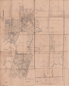
Map - PART PARISHES OF MANDURANG AND SANDHURST, No date visible
Map: Section of Parish plan of Bendigo covering Mandurang, Diamond Hill, and Quarry Hill, ( number 147 in Map Cupboard 1).Map 11map, bendigo, city streets, parish of mandurang, parish of sandhurst, diamond hill , quarry hill -
Bendigo Historical Society Inc.
Map - PART PARISHES OF SANDHURST MARONG AND NERRING, No date visible
... ( number 145 in Map Cupboard 1) Map PART PARISHES OF SANDHURST ...Map: Section of a Parish plan of Bendigo, covering Ironbark, Eaglehawk and Myers Flat ( number 145 in Map Cupboard 1)map, bendigo, city streets, parish of sandhurst, parish of marong, parish of nerring, ironbark, eaglehawk, myers flat -
Bendigo Historical Society Inc.
Map - PARISH OF HUNTLY(PART) AND SANDHURST(PART), No date visible
Map: Part of parish plan of Bendigo, covering Strathdale, White Hills, Huntly and North Bendigo ( number 144 in Map Cupboard 1)map, bendigo, city streets, parish of hunlty, parish of sandhurst, strathdale, white hills, huntly, north bendigo -
 Bendigo Historical Society Inc.
Plan - MCCOLL, RANKIN AND STANISTREET COLLECTION: PLAN OF SURVEY OF DAM SITE, 1941
McColl Rankin & Stanistreet, Plan of Survey of Dam site, Part of Crown Allotment 98 Section C, City of Bendigo, Parish of Sandhurst, County of Bendigo. Signed by Garnet G Birch 1 Feb 1941. 33.5 x 43. Attached is a Copy of Field notes, Dam Site in Crown Allotment 198 Sec. City of Bendigo, Parish of Sandhurst. True Meridian, County of Bendigo, Area 0A 1R 16P. Signed Garnet G Birch, 1/2/1941. Drawn in red and black pen. 20.8 x 33. Both maps are for Deborah Extended Gold Mining Co. No Liabilityorganization, mining, deborah extended gold mining co nl, mccoll rankin & stanistreet, plan of survey of dam site -
Bendigo Historical Society Inc.
Map - BENDIGO SHEET 12, Reproduced 1961
... of Bendigo Map; Bendigo Sheet 12, Parish of Sandhurst , County ...Map; Bendigo Sheet 12, Parish of Sandhurst , County of Bendigo, Parish plan, Scale 2 chains to 1 inch ( number 142 in Map Cupboard 1)map, bendigo, city streets, bendigo sheet 12, parish of sandhurst , county of bendigo -
Bendigo Historical Society Inc.
Map - PLAN OF THE TOWNSHIP OF SANDHURST(PHOTOCOPY)
Map: Photocopy of a plan of the Township of Sandhurst. Dated 26 July 1854 ( number 141 in Map Cupboard 1)map, bendigo, city streets, township of sandhurst, early bendigo, city streets -
Bendigo Historical Society Inc.
Map - PARISH OF SANDHURST SHEET 5A, 1970
... Map: Parish of Sandhurst Sheet 5A, County of Bendigo... Bendigo parish plan parish of Sandhurst County of Bendigo Map ...Map: Parish of Sandhurst Sheet 5A, County of Bendigo. Parish plan ( number 161 in Map Cupboard 1)map, bendigo, parish plan, parish of sandhurst, county of bendigo -
Bendigo Historical Society Inc.
Map - BENDIGO IRRIGATION SETTLEMENT, 12/02/1908
Map: Plan of Bendigo Irrigation Settlement, Parishes of Sandhurst and Wellsford, County of Bendigo ( number 160 in Map Cupboard 1)map, bendigo, irrigation settlement, bendigo irrigation settlement, parishes of sandhurst and wellsford, county of bendigo -
Bendigo Historical Society Inc.
Map - MANDURANG, November 6th 1854
Map: The village of Mandurang situated about 6 miles from Sandhurst, Parish of Mandurang ( number 155 in Map Cupboard 1)map, bendigo, village, mandurang -
Bendigo Historical Society Inc.
Map - SANDHURST (PART), No date Visible
... Bendigo parish plan Parish of Sandhurst Spring Gully Map: Hand ...Map: Hand Draughted parish plan showing the area North and East of Spring Gully Reservoir ( number 206 in Map Cupboard 1)map, bendigo, parish plan, parish of sandhurst, spring gully -
Bendigo Historical Society Inc.
Map - RESURVEY PARISH OF SANDHURST, 23/07/1891
... Bendigo parish plan Parish of Sandhurst Resurvey Map: Resurvey ...Map: Resurvey, Parish of Sandhhurst sheet No. IV, Enlargement of part of sheet No. III. Parish plan ( number 204 in Map Cupboard 1)map, bendigo, parish plan, parish of sandhurst, resurvey -
Bendigo Historical Society Inc.
Map - RESURVEY, PARISH OF SANDHURST, 1/08/1891
... Map: Resurvey , Parish of Sandhurst sheet 3. Parish plan... Bendigo parish plan Parish of Sandhurst resurvey Map: Resurvey ...Map: Resurvey , Parish of Sandhurst sheet 3. Parish plan ( number 203 in Map Cupboard 1)map, bendigo, parish plan, parish of sandhurst resurvey -
Bendigo Historical Society Inc.
Map - SANDHURST SHEET 2, No date visible
... ) Map SANDHURST SHEET 2 ...Map:Sandhurst, County of Bendigo Sheet 2. Parish plan, Eaglehawk. ( number 200 in Map Cupboard 1)map, bendigo, city streets, sandhurst -
Bendigo Historical Society Inc.
Map - SANDHURST : COUNTY OF BENDIGO (PART), Circa 1940's
... 195 in Map Cupboard 1) Map SANDHURST : COUNTY OF BENDIGO (PART) ...Map: Large scale (2 chains=1') of part of the city of Bendigo. Showing the area from Sommerville St. to Edwards Rd. Flora Hill ( number 195 in Map Cupboard 1)map, bendigo, city streets, bendigo, flora hill, sommerville st. -
Bendigo Historical Society Inc.
Map - TOWNSHIP OF KANGAROO FLAT, 27/01/1932
Map: Township of Kangaroo flat, Parish of Sandhurst , County of Bendigo. Parish plan ( number 194 in Map Cupboard 1)map, bendigo, township, kangaroo flat -
Bendigo Historical Society Inc.
Map - BENDIGO WEST IRRIGATION SETTLEMENT, 27/07/1910
Map: bendigo West Irrigation Settlement, Parish of Sandhurst, County of Bendigo. Parish plan ( number 193 in Map Cupboard 1)map, bendigo, irrigation settlement, bendigo west irrigation settlement -
Bendigo Historical Society Inc.
Map - BENDIGO WEST IRRIGATION SETTLEMENT, 13/02/1909
Map: Bendigo West Irrigation Settlement, Parish of Sandhurst, County of Bendigo. Parish plan. ( number 191 in Map Cupboard 1)map, bendigo, irrigation settlement, bendigo west irrigatioon settlement -
Bendigo Historical Society Inc.
Map - BENDIGO (COUNTY), Circa 1870's
Map:Plan showing the whole of the County of Bendigo-- attached handwritten sheet in the top left hand corner-'Proclaimed Commons Sandhurst District'. Also attached is a separate plan of the parish of Kimbolton (number 262 in map cupboard 1)map, bendigo, parish plan, bendigo, proclaimed commons -
 Bendigo Historical Society Inc.
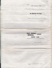
Document - MCCOLL, RANKIN AND STANISTREET COLLECTION: CENTRAL NAPOLEON GOLD MINING CO. N.L, 15th August 1950
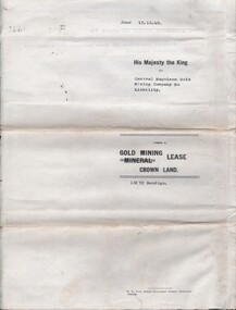
Document: Gold Mining Lease Crown Land No 11272 Bendigo, entered in the register book Vol 331 Fol 36450, embossed seals of Central Napoleon Gold Mining Co N.L & King George VI, Map: No 11272 Mining District of Bendigo, Parish of Sandhurst, County of Bendigo, shows the minerunning between Harvey & Inglis Streets and crossing Empire and Sparrowhawk Roads and running a good distance beyond Sparrowhawk Rd.organization, business, industrial - mining, mccoll rankin & stanistreet, mining, gold mining, central napoleon -
 Bendigo Historical Society Inc.
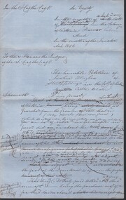
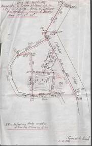
Document - MCCOLL, RANKIN AND STANISTREET COLLECTION: NORTH VIRGINIA GOLD MINING COMPANY NL, INDENTURE, 1936
McColl Rankin & Stanistreet, North Virginia Gold Mining Company NL, a/ Indenture operating on operations in the Parishes of Nerring and Sandhurst. Hold crown land for the tern of 13 years and 53 days expiring on July 27, 1949. Map glued to page 5 runs from Hodgson Street to Orlando St and covers Newton, Reef, Fry & Leslie Street and Sailors Gully Road I the Parish of Sandhurst. Dated: 4/6/1936. Signatures: W Daly and ? Mining lease number 10859 Bendigo, b/ Indenture, North Virginia Gold Mining Company NL. Signed: J B ?, A Mackay & ? Dated: 8/1/1940. c/ Indenture, North Virginia Gold Mining Company NL. 960 still owing by the company, the company has applied to the minister to advance the company the further sum of 500 pounds which the minister consented to. Signed: J ?, A Mackay & Stanistreet?cottage, miners, mccoll rankin & stanistreet north virginia gold mining company nl indenture 1949 lease 10859