Showing 23140 items matching "side"
-
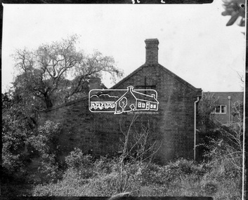
 Charlton Golden Grains Museum Inc
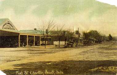
Postcard, High St. Charlton, South Side, c.1907
Charlton Foundry 1907 owned and operated by Dabrons. Had 20-30 employees.Copy of hand coloured post card. Shows High St Charlton on the south side looking west. Includes Foundry and residence, man unloading a cart. Another wagon is in front slightly down the street. Road is unpaved. One of a set of postcards taken in 1907. Writing at the bottom of the card reads High St. Charlton, South Side.dabron, charlton, foundry, high street, business, industry -
 Ballarat Tramway Museum
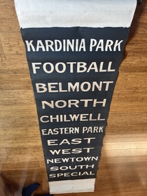
Functional object - Destination Roll, State Electricity Commission of Victoria (SECV), " Geelong" (black background) - side destination roll, 1946
Destination roll used to indicate to passengers the destination or route of the tram. At night the roll was backlit by two light bulbs fitted to the destination box on the tram. Item used in Geelong until 1956. Based on the handwritten marking, painted in July 1946. Used on the side destinations of either the Pengelley or the trams built for MESCo trams such as Geelong No. 2. See Reg Item 2906 for another smaller side destination roll and 4122 for a wide roll fitted to bogie tram No. 39 and 9618 wide roll fitted to a Pengelley tram. Destinations have the same arrangement to that of item 2906.Yields information and demonstrates aspects about Geelong's destination rolls used in trams up to 1956 when the system closed.Destination roll - white lettering on black background - using black paint leaving the lettering transparent at night. Uses a book binders cloth. Attached to a wooden blind roller, as used in the destination box to keep the blind tight. Wooden roller has a "Hartshorns" and "Stewart Gladstone" name lable attached to it.In pencil as base of roll "Taubmans Black 4-7-46 JS" tram, trams, geelong, destination roll -
 Ringwood and District Historical Society
Photograph, Freeway site. Virgin bush. Ringwood Street looking west along south side Mullum Creek. Ringwood Late 1980
Written on back of photograph, "Late '80. Freeway site. Virgin bush. Ringwood Street looking west along south side Mullum Creek." -
 Stawell Historical Society Inc
Slide, View of the Eastern side of Lake Bellfield during construction
Lake Bellfied during ConstructionColour Slide: View of the eastern side of Lake Bellfied during construction showing an Sign with a solid red cirlce on a white Squre background. -
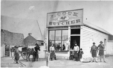 Stawell Historical Society Inc
Photograph, Mr J Cocks wooden Butchers Shop in Main Street Stawell on West side of Town Hall
Wooden Butcher’s Shop (J. Cock) Main Street Stawell on West side of Town Hall with butchers wearing aprons and horse drawn cart out front. Note sheep carcases hanging out in open air.stawell business -
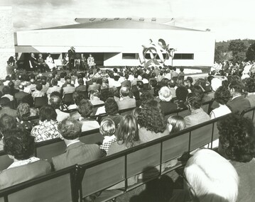 Ringwood and District Historical Society
Photograph, Official opening of the Karralyka Centre, Mines Road, Ringwood on 19/4/1980 - Victorian Governor Sir Henry Winneke addressing the gathering. Theatre in the background, west side, 19-Apr-80
Official opening of the Karralyka Centre - Sir Henry Winneke addressing the gathering. Theatre in the background, west side. +Additional Keywords: Winneke, Sir Henry -
 Buninyong & District Historical Society
Photograph - Original Photograph, Derek Leather, Learmonth Street, north side shops near Warrenheip corner, taken from SW corner or intersection. 1970's, Copy of original photograph made 1970-80
Historic BuildingsB/W Photo Learmonth Street, north side shops near Warrenheip corner, taken from SW corner or intersection. 1970's.buninyong, learmonth st., shops -
 Buninyong & District Historical Society
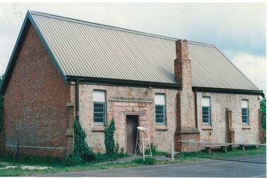
Photograph - B/W photograph, Mr. C J Brooks, Buninyong Uniting Church (formerly Presbyterian) side view, July 1993
Built in 1860 by Richard Rennie as Presbyterian ChurchRichard Rennie building, unusual designB/W photo of Uniting Church looking uphill from eastern side, showing gables and buttresses, belltower and steeple. Formerly Presbyterian Churchbuninyong, presbyterian, uniting, church, building, learmonth st -
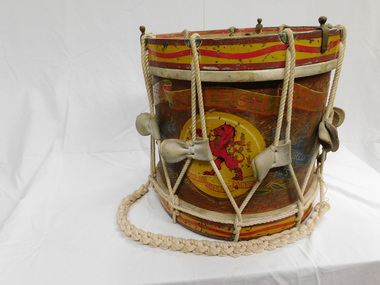 The 5th/6th Battalion Royal Victoria Regiment Historical Collection
Instrument - Drum, Drum - Side Tension VSR
Used by VSR Pipes and drumsSide Drum is of wooden construction with rope tension system. Drum is hand painted with VSR title rampant lion eith VSR battle honours.5/6 rvr pipes and drums, vsr, instrument, side tension drum, 5/6 rvr bhq -
 Whitehorse Historical Society Inc.
Photograph, Antonio Park - The Shack - East side, C1960
The photo is part of a set provided by Robin Harris of his early life (1953-1962) in 'The Shack' at Antonio Park. See ND5241 for his story 'When Antonio Park was home'.)Black & white photograph of the Shack in Antonio Park (1953-1962) showing the eastern side which faced Deep Creek Road. See ND5241 for history.antonio park mitcham, the shack, whitehorse road, mitcham, no.627, harris. robin, bushfire - 1962 -
 Buninyong & District Historical Society
Photograph - B/W photograph, Eyre Cottage, former home of Robert Allen, c 1855, on S/W cnr. of Eyre and Winter Streets, side view from N/W, 1994
Original Building dates from around 1855, strong connection with Robert Allen, prominent citizen in early goldrush, links through him to Allen Store and Old Library.Built by prominent citizen and benefactor, early gold-rush dwellingEyre Cottage, former home of Robert Allen, c 1855, on S/W cnr. of Eyre and Winter Streets, side view from N/W.buninyong, eyre st, winter st, robert allen, streetscape, building -
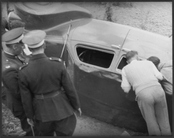 Greensborough Historical Society
Photograph - Digital image, George Thomas, Lancia on its side, Greensborough Hill Climb, 07/10/1945
This 1945 photograph of a Lancia on its side in the Greensborough Hill Climb 1945 was taken by George Thomas. It is from the State Library of Victoria collection. [Refer to article in The Western Mail (Perth) on 8th November 1945 page 43. 'Greensborough Hill' may be in Western Australia!] Digital copy of black and white photo.greensborough hill climb 1945, george thomas -
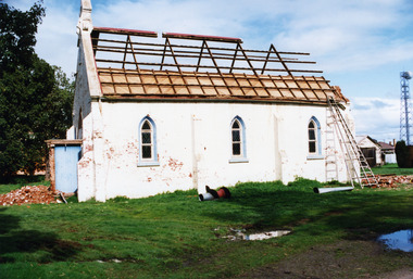 Charlton Golden Grains Museum Inc
Photograph, St Andrews Charlton Presbyterian Church demolition c.1989 side view, c.1989
The St Andrew Charlton Presbyterian Church was built in 1871 by James Patterson, a contractor and grazier of Nardoo Park, Woosang. Dismantled in 1989, The view is of the side of the church and the roofing has already been remove. The roof timber have been exposed. Bricks litter the ground.Colour Photo of St Andrews Presbyterian Church. Being demolished in c.1989. View is from the back.charlton presbyterian church, james patterson, church, presbyterian, pastoral care, manse, demolition -
 Federation University Historical Collection
Document, City of Ballarat - Building Permit for Grant Street, South Side, East of Armstrong Street
School of Mines Ballarat, is a predecessor of Federation UniversityPale blue/green A4 document - City of Ballarat - Building Permit for Grant Street, South Side, East of Armstrong Street issued to the School of Mines BallarartNumber stamp on top right hand corner city of ballarat, ballarat school of mines, the ballarat school of mines and industries, j.b. menhennet, building permit, recreation building -
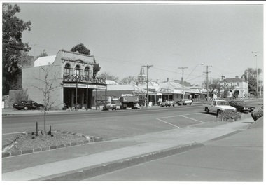
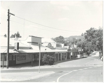 Buninyong & District Historical Society
Photograph - Photograph of Original Postcard, Derek Leather, North side Warrenheip St. 1970's, looking east towards Mount Buninyong, 1970-80's
Historic BuildingsB/W Photo North side Warrenheip St. 1970's, looking east towards Mount Buninyong down service road, corner shop to supermarketbuninyong, learmonth st., corner shop -
 Linton and District Historical Society Inc
Photograph, Linton State School Building, West Side
The photograph is undated, however a copy is owned by Betty Grigg, which suggests that the photograph shows members of the Grigg family and was taken in the 1960s. The copy in the LDHS collection was printed for the school display in 2017.Copy of original black and white photograph which shows part of the west side of the school building. Two boys are playing near drinking taps outside the building.linton state school no. 880, buildings, grigg boys? -
 Ringwood and District Historical Society
Photograph, Edwin G. Adamson A.R.P.S, Maroondah Highway Central, Ringwood. Adelaide St Footpath - West Side,1963. (Eastland Litigation Photo), May 1963
This series of SS0380 photos are part of the "Eastland Litigation" launched in 1962 by the Whitehorse Traders Co-operative Association (WTCA), against the Ringwood Council's Interim Development Order of 1960. WTCA sought "orders from the Supreme Court of Victoria that the planning scheme was invalid" - See "The Eastland Litigation" chapter in "From Horse Shoes to High Heels - Ringwood Shopping Centre and Eastland 1858-2008" by Richard Carter, Bounce Books 2009.Black and white photograph Written on back of photograph: "Photo of the footpath on West side of Adelaide St, showing how it is unmade and unkempt." Stamp on back of photograph, 'Edwin G. Adamson...May 63'. -
 Buninyong & District Historical Society
Photograph - Original Photograph, Clive Brooks, Original Anglican Church/Common School (1857), east side, 9 Nov. 1991
detail of historic buildingColour photo Original Holy Trinity Anglican Church/Common School (April 1857), east side. Part of tennis court visible in foreground, with net and umpire's stand.buninyong, holy trinity, tennis court, anglican, church, common school -
 Ringwood and District Historical Society
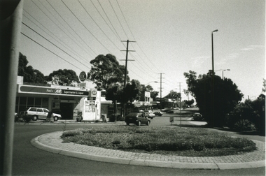
Photograph-B&W, Joan Walker, East Ringwood 2000- Roundabout in Railway Avenue cnr Wenwood Street looking West (railway line on right hand side), 2000
East Ringwood 2000- Roundabout in Railway Avenue cnr Wenwood Street looking West (railway line on right hand side)- B&W Photo from Album 6501 -
 Whitehorse Historical Society Inc.
Photograph, View east side Mitcham Road, c. 1987
The site was the former medical rooms of Dr Stanley Cochrane and Dr Vernier ThrelkeldBlack and white photograph of the east side Mitcham Road, opposite Victoria Street, showing the office block, now (in 2004) occupied by Jobs East. c. 1987|See Historymitcham road, mitcham, victoria street, cochrane . stanley dr, threlkeld, verner w. dr. -
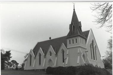
 Buninyong & District Historical Society
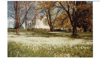
Photograph - Original Colour Photograph, Buninyong Uniting Church (formerly Presbyterian, 1860), north side, from Learmonth St, 1982
Record of Victorian era church in 1980's. Colour photo, Buninyong Uniting Church (formerly Presbyterian, 1860), north side, from Learmonth St. Viewed through trees that are coming into leaf, lawn carpeted in white flowers.uniting church, presbyterian church, learmonth st., trees, flowers -
 Port Melbourne Historical & Preservation Society
Photograph, James Lauritz, West side of Centenary Bridge looking towards Government Engine Works, 1989 - 1990
West side of Centenary Bridge looking towards Government Engine Works. James Lauritz print of Port Melbourne, laminated (one of 18). Copies of slides produced for Port Melbourne Counciljames lauritz, commonwealth government engine works, piers and wharves - station pier, centenary bridge -
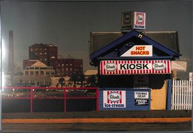 Port Melbourne Historical & Preservation Society
Photograph, James Lauritz, The kiosk on the Eastern side of Station Pier, 1989 - 1990
The kiosk on the Eastern side of Station Pier. Sandridge Bay Towers is on the left. James Lauritz print of Port Melbourne, laminated (one of 18). Copies of slides produced for Port Melbourne Councillocal government - city of port melbourne, built environment, james lauritz, station pier kiosk, sandridge bay towers -
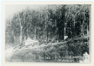 Mt Dandenong & District Historical Society Inc.
Photograph, Side View Mr G. Barber Homestead Mt Dandenong, c1905
Built in 1898 by early settler George Barber the property is still in existence today. It was the home of George, wife Sarah Ann and daughter Ethel.Black and white photograph showing te side view of George Barber's home, later named Forest Edge. c1905. Reverse of photograph has handwritten description by John Lundy-Clarke.Barber's home on Olinda Creek. Lot 25 Sect 1 Village Settlement. Home of George Barber and wife Sarah Ann (nee Richardson). Daughter Ethel.Was bought by Munnerley later Sangster and Kinnear. Later known as Forest Edge. Buggy and wagon shed on right. Photo copied 1973 by JLC. -
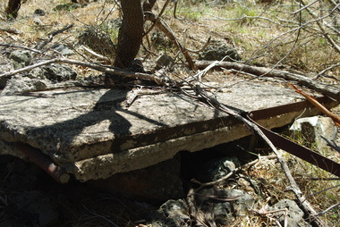 Greensborough Historical Society
Photograph - Digital image, Marilyn Smith et al, Janefield Precinct: Side view showing reinforcements, 27/11/2014
Janefield Precinct: Side view showing reinforcements. The remains of this site are between Greensborough and Janefield. A RAAF Hygiene Training Camp was located on the Plenty River, just south of the Janefield community. It was in use from 1944 to 1946. The Camp was constructed from salvaged materials. Instruction included building and maintenance of grease traps, latrines, elementary plumbing and carpentry.Early remains of a WW2 training camp Digital colour photograph. -
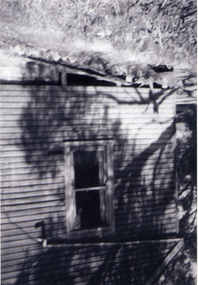
 Eltham District Historical Society Inc
Photograph, Side view of Shillinglaw Cottage
Side view of 'Shillllinglaw Cottage' in its original location on Main Road Eltham, 1964. The cottage was built by George Stebbings about 1859 and is made from hand made bricks laid in a Flemish bond pattern. In the 1960s it was marked for demolition to make way for the construction of new council buildings but a community campaign saved the cottage and it was re-located.Shillinglaw Cottage is itself historically, aesthetically and socially significant to the Shire of Nillumbik and is registered on the Victorian Heritage Database. This photo forms part of a collection of photographs gathered by the Shire of Eltham for their centenary project book, "Pioneers and Painters: 100 years of the Shire of Eltham" by Alan Marshall (1971). The collection of over 500 images is held in partnership between Eltham District Historical Society and Yarra Plenty Regional Library (Eltham Library) and is now formally known as 'The Shire of Eltham Pioneers Photograph Collection.' It is significant in being the first community sourced collection representing the places and people of the Shire's first one hundred years.Digital imagesepp, shire of eltham pioneers photograph collection, eltham, shillinglaw cottage -
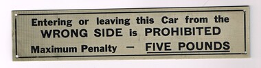 Melbourne Tram Museum
Sign, Melbourne & Metropolitan Tramways Board (MMTB), "Entering or leaving this Car from the WRONG SIDE is PROHIBITED", 1970's?
Sign - engraved brass sheet, with black lettering and lining on the outside and screw holes in each corner with the words. "Entering or leaving this Car from the WRONG SIDE is PROHIBITED / Maximum Penalty - FIVE POUNDS"trams, tramways, signs, tramcars, tramways, passengers, behaviour -
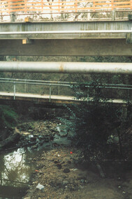 Ringwood and District Historical Society
Photograph, Ringwood, Mullum Mullum Creek, east side. Warrandyte Road Bridge. 1986
Written on backing sheet, "Bridge, Mullum Rd. Completed May 1987." Writing on back of photograph reads, "Aug., 1986. Ringwood, Mullum Mullum Creek, east side. Warrandyte Road Bridge". -
 Buninyong & District Historical Society
Photograph - Original B/W Photograph, Clive Brooks, Warrenheip St Buninyong, east side, between Forest and Learmonth, 18/9/1993
Record of central Buninyong 1993B/W photo, Warrenheip St Buninyong, east side, between Forest and Learmonth, former Eagle Hotel at centre, Former National Bank far right, Town Hall Tower visible in background. buninyong, warrenheip st., eagle hotel, national bank -
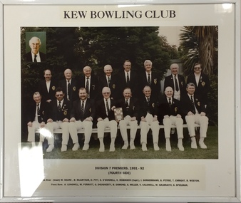 Kew Historical Society Inc
Photograph - Framed Photograph, Kew Bowling Club Division 7 Premiers (Fourth side), 1991-92, 1991-1992
Sports Clubs in Kew in the final decades of the 19th century and in the early 20th century were often umbrella organisations with facilities for a number of sports. Typically in Kew, this included teams in lawn bowls, tennis and croquet. The Kew Bowling Club was formed in 1880 while the privately owned Auburn Heights Recreation Club was opened in 1904. By 1998, the two Clubs decided to amalgamate at the Auburn Heights site in Barkers Road, forming the Kew Heights Sports Club. The combined club was itself taken over by the Melbourne Cricket Club in 2012 becoming MCC Kew Sports Club. In 2017 MCC Kew closed and its landholding was subsequently sold to Carey Baptist Grammar School. Both the Kew and Auburn Heights Clubs assembled important collections. These historically significant and large collections were donated to the Society in 2020. The collections include manuscripts, pictures, trophies, plans, honour boards etc. References Barnard FGA 1910, 'Sports and Pastimes' in Jubilee History of Kew Victoria: Its origin & progress 1803-1910. Nixon NV 1980, The History of the Kew Bowling Club 1880-1980. Reeve S 2012, City of Boroondara: Thematic Environmental History, p.216.The combined collections of the four sporting clubs making up the collection number hundreds of items that are historically significant locally. They are also significant to the sporting history of the greater Melbourne area and to the sports of lawn bowls and tennis in Australia in the 19th and 20th centuries. The collection illuminates two of the Victorian historic themes - 'Building community life' through forming community organisations and 'Shaping cultural and creative life' by participating in sport and recreation.Framed and glazed photograph of Division 7 Premiers (Fourth side), 1991-92. [The item is part of the large historic Kew Bowling Club collection (1880-1988) gifted to the Kew Historical Society in 2020].kew bowling club - wellington street - kew (vic), clubs - lawn bowls - kew (vic)