Showing 829 items
matching slide sets
-
 Ballarat Tramway Museum
Photograph - Digital image Set of 10, Tony Smith, 19/09/1971 12:00:00 AM
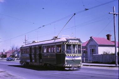
... of the system. This set of slides appears to be the last day... 35 tram 42 tram 39 tram 34 Set of 10 digital images ...Yields information about Ballarat Tramways and trams prior to the closure of the tramway system.Set of 10 digital images of Ballarat trams prior to closure, scanned from original slides by Tony Smith, 1971 prior to closure of the system. This set of slides appears to be the last day of operations - 19/9/1971 .1 - 40 in Drummond St Nth. near Macarthur St, showing Sebastopol. .2 - 35 turning from Drummond St north into Sturt St with the Southern Cross hotel in the background. Note the shoes in the overhead. .3 - 42 in Drummond St North, showing Special, nearing Sturt St. .4 - 42 turning into Sturt St, with the Shell Service station on the left. .5 - 42 reversing on the Lydiard St Nth crossover with the post office in the background. Tram showing Sebastopol. .6 - 39 reversing at Grenville St, tram showing Special. Has the Dickins and the Gasometer in the background. the conductor adjusting the trolley ropes. .7 - 39 running from Bridge St into Sturt St - as above. .8 - 34 and 39? parked in the City Loop. Has Patersons furniture, Gear Chemist and Edments stores in the background. .9 - 43 showing special at the Sturt and Lydiard St stop with 39? about to leave Lydiard St Nth. Has the post office in the background. .10 - 40 at the Lydiard St North terminus, with passengers boarding. Cemetery gates in the background.trams, tramways, drummond st nth, macarthur st, sturt st, closure, lydiard st nth, grenville st, city loop, closure, tram 40, tram 35, tram 42, tram 39, tram 34 -
 Ballarat Tramway Museum
Photograph - Digital image Set of 10, Tony Smith, 5/09/1971 12:00:00 AM
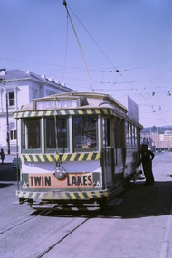
... of the system. This set of slides, possibly on the last weekend of Mt... tram 14 tram 12 tram 27 tram 39 Set of 10 digital images ...Yields information about Ballarat Tramways and trams prior to the closure of the tramway system.Set of 10 digital images of Ballarat trams prior to closure, scanned from original slides by Tony Smith, 1971 prior to closure of the system. This set of slides, possibly on the last weekend of Mt Pleasant services - closure took place on 5/9/1971. . .1 - 17 at the City terminus, north side. Tram showing the destination of Sebastopol and has a Twin Lakes sign. .2 - 26 at the city terminus, south side with Geommola's Pharmacy and Kodak Film advert and Town Hall in the background. .3 - 43 at the City terminus, north side, with destination of Mt Pleasant. Has a number of men at the tram stop. .4 - 14 leaving Bridge St, crossing Grenville St into Sturt St, with destination of City. Has the Dickins and Woolworths Big W store in the background. .5 - 43 at Mt Pleasant terminus with conductor boarding the tram. Tram has destination of Gardens via Sturt St West. In the background is the corner store with adverts for The Sun, Womens Weekly, Coca Cola and Robur Tea. .6 - 43 and 26 Barkly St, about to arrive at the Grant St loop. Both trams inbound. .7 - 43, 26 and 27 at Grant St loop. .8 - 12 (Lydiard St Nth) and another bogie tram at the city terminus north with the Town Hall in the background. .9 - 39 outbound in Barkly St to Mt Pleasant - note the new bus stop signs on either side of the tram. 10 - 27 (City) and 26 turning from Barkly St into Main St with the Ampol petrol station, a general store advertising Escort cigarettes and The Age in the background . On the right hand side is a fish and chips shop advertising crays and drinks.trams, tramways, sturt st, city, grenville st, bridge st, mt pleasant, barkly st, grant st, main st, closure, tram 17, tram 26, tram 43, tram 14, tram 12, tram 27, tram 39 -
 Ballarat Tramway Museum
Photograph - Digital image Set of 10, Tony Smith, 5/09/1971 12:00:00 AM
... of the system. This set of slides, possibly on the last weekend of Mt... to closure of the system. This set of slides, possibly on the last ...Yields information about Ballarat Tramways and trams prior to the closure of the tramway system.Set of 10 digital images of Ballarat trams prior to closure, scanned from original slides by Tony Smith, 1971 prior to closure of the system. This set of slides, possibly on the last weekend of Mt Pleasant services - closure took place on 5/9/1971. . .1 - 30 rounding the curve from Lydiard St Nth to Sturt St. Tram has destination of Sebastopol. IN the background is the Commonwealth bank and the SEC cabinet switch isolator on the corner. .2 - 13 and another single trucker at the City terminus, north side with Racey's store and the SEC offices in the background. 13 has a Twin Lakes sign and the destination of Victoria St. .3 - 26 (Mt Pleasant) and 27 at the city terminus, with many passengers. Has the town hall in the background. .4 - 14 turning from Sturt St into Lydiard St (destination does not appear to be Lydiard St nth - City Oval?) with the ANZ bank in the background. A number of passengers waiting at the tram stop. .5 - 14 in Sturt St west near Pleasant St, at City Oval, with the pole being reversed by a "Bounds". Tram has the destination of City Oval. .6 - 13 west bound (showing Mt Pleasant) at Pleasant and Sturt St, with the VicRoads (CRB) offices and St Peters Anglican church in the background. .7 - 13 and 14 in Sturt St west, opposite City Oval (see .5 and .6) - trams reversing. .8 - 13 and 14 at Grenville St, about to cross into Bridge St from Sturt St. .9 - 14 at ditto - both trams for Mt Pleasant. Has the Patersons furniture store in the background. .10 - 30 eastbound in Sturt St, near Armstrong St with the Crockers store in the background. Tram showing "Special"trams, tramways, sturt st, electrical switching, city oval, lydiard st, pleasant st, grenville st, tram 30, tram 13, tram 26, tram 14 -
 Eltham District Historical Society Inc
Work on paper - Folio, Register of Significant Trees, Shire of Eltham, c.1993
... a set of slides showing each tree. Garry Bartlett... a set of slides showing each tree. Garry Bartlett ...In 1983, the National Trust advised the Shire of Eltham that it was investigating a number of trees within the shire which had been nominated for recording the Register of Significant Trees of Victoria. The trees involved were described in the Shire of Eltham Historical Society Newsletter No. 29, March 1983 as follows:- 1. Eucalyptus melliadora (Yellow box) . a) An outstanding mature specimen 42 metres high in Laughing Waters Road, Eltham. b) Another mature specimen in Arthurs Creek road, Hurstbridge is reported to be the tree under which the bushranger Robert Bourke was tied after he shot and killed Henry Hurst in 1866 . 2. Quercus robur (English Oak). a) "Donaldson's Oak", Donaldsons Road, Kangaroo Ground was planted by John Donaldson from seed collected from Windsor Great Park in 1878. b) "Wippells Oak". This now misshapen tree is located on the St. Andrews Road near the Kangaroo Ground Fire Station. Its origins may have been similar to Donaldson's Oak, and as a young tree it apparently slipped from higher up the hill during wet weather. Both oaks are of local historical importance. 3. Eucalyptus globulus (Blue Gum). A large mature specimen at the corner of the Kangaroo Ground-St. Andrews Road and Bakehouse Road, Panton Hill. 4. Plantanas acerifolia (Plane tree) A number of trees forming the Avenue of Honour to Eltham's First World War soldiers along Main Road between Dalton and Pitt Streets, Eltham. 5. Pinus canariensis (Canary Island Pine), Pinus pinea, (Stone pine) and Cedras altlantica, (Cedar) These trees are located at the Hurst family graves in the grounds of the Hurstbridge Pre-school Centre. In 1991 the Shire of Eltham introduced controls into its planning scheme to protect sites of architectural, historic or conservation interest and significant trees. The controls were approved by the Minister for Planning and Housing. As advised in the Shire of Eltham Historical Society Newsletter No. 78, May 1991, a planning permit is required to demolish or alter any listed building or to destroy, lop or remove any listed tree. Provision is made for comments to be obtained from the National Trust or Historic Buildings Council in considering any applications. The buildings and trees listed were: Buildings: 250 Bolton Street Eltham (former Walter Withers home) "Rosehill" - Bonds Road Lower Plenty St Andrews Church of England - St Andrews "Montsalvat" - Hillcrest Avenue Eltham St Margarets Church and former vicarage - Pitt Street Eltham Presbyterian Church - Kangaroo Ground Parks and Environment Office (former police quarters) Main Road Eltham Former Court House - Main Road Eltham "Shillinglaw Cottage" - Main Road Eltham "The Robins" - Kangaroo Ground Road Warrandyte Trees: "Donaldsons Oak" - Donaldsons Road Kangaroo Ground Yellow Box - Laughing Waters Road Eltham Yellow Box - Arthurs Creek Road Hurstbridge Wippells Oak - St Andrews Road Kanqaroo Road Pines and Cedar - Hurst family cemetery Greysharps Road Hurstbridge Yellow Box - Parsons Road Eltham A large Blue Gum at Panton Hill has been listed but has recently died (1991). In 1993 work by Council Parks and Environment staff and volunteers resulted in the preparation of a Significant Tree Register listing forty-one trees or groups of trees. According to Shire of Eltham Historical Society Newsletter No. 91, March 1993, a similar number remained to be assessed for inclusion in the register. There is a wide range of indigenous and planted trees on private and public land and extending through the Shire of Eltham from Lower Plenty to Kinglake. Most can be viewed from publicly accessible locations. The Significant Tree Register lists 41 trees or groups of trees throughout the Shire. It contains a wide range of naturally occurring and planted trees. They have been assessed according to eleven criteria including size, age, rarity, historical value and the like. The list includes large old Red Gums at Lower Plenty, historic Oaks at Kangaroo Ground and Mountain Ash at Kinglake. The register includes a set of slides showing each tree. Garry Bartlett of the Council's Parks and Environment Section and Faye Shepherd were extensively involved in establishment of the register (Newsletter No. 93, November 1993). In 1999 Niliumbik planners prepared an amendment to the Planning Scheme to provide protection for approximately 200 of the places listed in the heritage studies and also in the Significant Tree Register commenced by the Eltham Council (Eltham District Historical Society Newsletter No. 127, July 1999. In 2004, The Register of Significant Trees was presented to the Eltham District Historical Society by Nillumbik Shire Council as part of a wider collection of of its memorabilia of the former Eltham Shire Council (EDHS Newsletter No. 159, July 2004. Album of loose handmade paper sheets contained within a handmade slip cover constructed of handcrafted card with encapsulated flora material (flowers, vines, ferns) and tinted. Each page also contains an embedded/adhered fern leaf also tinted with lacqueur or similar, text as appropriate in ink by hand calligraphy. Each page also has a white protective sheet cut to size and adhered to back surface with sticky tape and folded over face of page. Pages variously have photographs and coloured masks adhered with a gum resin. Over time much of this resin has let go and photos/masks have been reattached using acid free archival safe adhesive. 15 pages 41 x 29 cm inclusive of 3 blank pages. Slip case 42 x 30 x 1 cm; face cover of slip case has broken off at left hand margin as insufficient depth/flexibility for contents.arthurs creek road, blue gum (eucalyptus globulus), canary island pine (pinus canariensis), couties road, donaldsons oak, donaldsons road, eltham, english oak (quercus robur), eucalyptus melliodora, graysharps road, hurst tree, hurstbridge, ironbark (eucalyptus tricarpa), ironbark hill, kangaroo ground, kangaroo ground-kinglake road, laughing waters road, panton hill hotel, panton hill, parsons road, significant trees register, sonia van bodegraven, sonjart, stone pine (pinus pinea). atlantic cedar (cedrus atlantica), wippells oak, yellow box gum (eucalyptus melliodora), yellow box gum -
 The Beechworth Burke Museum
Photograph - Lantern Slide, c1900
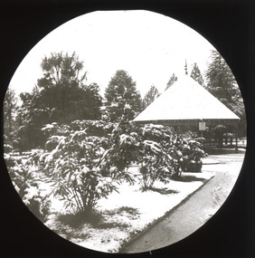
This image shows a pathway in the gardens adjacent to Beechworth's Town Hall at the beginning of the Twentieth Century, around the time of Australia's Federation. The pathway leading to a circular rotunda or covered seating area with a steep conical roof is lined with shrubs set in grass verges that appear to be covered with snow. It is unknown whether the snowfall or a factor to do with the gardens occasioned the taking of the image, which at the time may have been an exotic practice. Climate records going back to 1908 indicate that snow in winter is not unusual due to Beechworth's elevation and orientation, and the Town Hall itself was built in 1859. Lantern slides, sometimes called 'magic lantern' slides, are glass plates on which an image has been secured for the purpose of projection. Glass slides were etched or hand-painted for this purpose from the Eighteenth Century but the process became more popular and accessible to the public with the development of photographic-emulsion slides used with a 'Magic Lantern' device in the mid-Nineteenth Century. Photographic lantern slides comprise a double-negative emulsion layer (forming a positive image) between thin glass plates that are bound together. A number of processes existed to form and bind the emulsion layer to the base plate, including the albumen, wet plate collodion, gelatine dry plate and woodburytype techniques. Lantern slides and magic lantern technologies are seen as foundational precursors to the development of modern photography and film-making techniques. This glass slide is significant because it provides insight into Beechworth's social amenities and climate in the early Twentieth Century, around the time of Australia's Federation into one nation. It is also an example of an early photographic and film-making technology in use in regional Victoria in the time period. Thin translucent sheet of glass with a circular image printed on the front and framed in a black backing. It is held together by metals strips to secure the edges of the slide.burke museum, beechworth, lantern slide, slide, glass slide, plate, burke museum collection, photograph, monochrome, town hall, town hall gardens, snow, rotunda, magic lantern, indigo shire, north-east victoria, nineteenth century, 1900s, twentieth century, emulsion slides -
 Orbost & District Historical Society
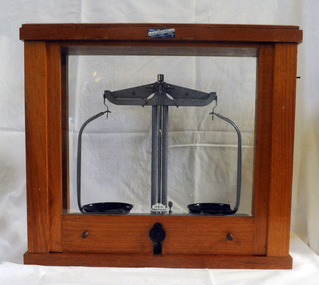
beam balance, second half 20th century 1954-1999
These scales were used by students at St Joseph's School in Orbost. St Joseph's Catholic School in Orbost was planned from 1913 when the town's population was increasing rapidly. It wasn't until 1923 that the school was built in Raymond Street next to St Colman's Church. The Catholic school was opened in thecharge of Sister Moira and Sister Lucy, Fifty-five students were initially enrolled and taught in two rooms. When the numbers increased to 170 work began on extensions which were completed in 1959. St Joseph's school had classes to Form 4 at one stage. Later on Form 2 was the highest level. However, after Nagle College at Bairnsdale built a new school on the Lindenow Road site, a Nagle College school bus ran from Orbost and the school was reduced to Grade 6. It was also about this time that the last of the St Joseph teaching nuns left Orbost. From 1969 to the early 1980s the secondary St Joseph students attended Orbost High School for the practical subjects of Woodwork and Home Economics. Today enrolments reflect the declining population of the district.This item is an example of early school equipment.A set of beam balance scales in a wooden framed cabinet with glass windows on all for sides. The front is a vertical slide which allows acess to the scales. The scales have one fixed leg and two adjustable legs for accurate levelling. GRIFFIN GEORGE LIMITED, LONDON, BIRMINGHAM, MANCHESTER label on front of wooden section of case -ANALITE PTY LTD ASG@W EDINBURGH MADE IN GREAT BRITAIN MINOR REG DES No's 891235 & 891238education science scientific-apparatus measurement -
 Orbost & District Historical Society
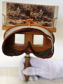
stereoscope, April 1920
This is a wood stereoviewer with folding handle The viewer has two lenses at a set distance in the wooden hood which is lined in green velvet. The pictures can be moved vertically on the slide holder in order to focus them. These devices became popular in the middle of the 19th century. This is probably a Holmes type stereoscope, named after its inventor, Oliver Wendell Holmes (1860). Velvet lined view mask with engravwed patterns. Frame is silky oak wood with a handle underneath.stereoscope audio-visual appliances -
 Ballan Shire Historical Society
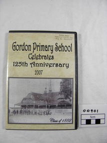
DVD. Gordon P/S, Gordon Primary School Celebrates 125th Anniversary 2007, 2007
... , functions, etc. over the last 125 years. A pictorial history set out... 125 years. A pictorial history set out in five (slide show ...This DVD was produced to celebrate the 125th Anniversary of the Gordon Primary School in 2007. It is a pictorial history covering that period consisting of still photographs in a slide show format.DVD in a plastic case with a custom printed cover insert depicting a photograph of Gordon Primary School Class of 1882. Contains still photographs of staff, students, school grounds, functions, etc. over the last 125 years. A pictorial history set out in five (slide show) chapters with a sound track to accompany. DVD compiled and designed by Diane Lawson 2007. All proceeds from the sale of this DVD will be donated to the Gordon Primary School.school, gordon, primary school, 125th anniversary -
 Bendigo Military Museum
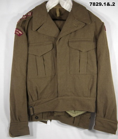
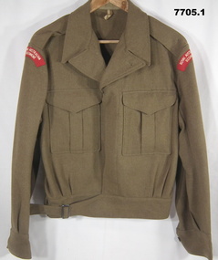
Uniform - BATTLE DRESS, ARMY, 1953 and 1960's
Names recorded on manufacturers label on jacket. "J.E. COOK", "W. RICHARDSON", "MENTONE GRAMMAR".1. Jacket - Khaki colour wool serge fabric. Battle Dress style, belted at waist with metal buckle. Brown plastic buttons. Collar, shoulder epaulettes with three red, cream and brown fabric rank insignia = Captain. Two front pockets with concealed button down flap. Shoulder sleeve insignia - red with cream colour embroidered lettering "ROYAL AUSTRALIAN ARMY/ MEDICAL CORPS". Sleeves with cuff and button. Light Khaki colour cotton fabric - pocket and waist lining. Manufacturers white cotton fabric label (two) on right pocket lining. 2. Trousers - khaki colour wool serge fabric Battle dress style. Two side pockets, two inset rear pockets with concealed button flaps and one patch pocket left thigh with concealed button flap. Five button fly. Waistband with button down belt keepers. Trouser cuffs have fabric tab with two buttons. khaki colour cotton fabric lining to waistband and pockets. Manufacturers white cotton label on waistband. 3. Braces - set of cotton elastic braces with brown leather button attachments for trousers. Stripes on elastic are beige, black, blue, cream and green in colour. Metal slides for adjustment to wearers size, with stamped lettering. brown leather strap joiner.Manufacturers information on labels. 1. Black ink print "REGIMENTAL NO./ NAME". Handwritten blue ink pen "JE COOK/ MENTONE/ W. RICHARDSON/ GRAMMAR". Red ink print label "M.TX/ SIZE 8" , Purple ink stamp on fabric lining "D^D/ MADE IN AUSTRALIA/ 1953". 2. Black ink print "REGIMENTAL NO./ NAME". Red ink print "M.TX/ SIZE 5". 3. Lettering on metal slides "POLICE/ AND/ FIREMEN". Black ink stamp - back leather strap joiner "???/ ^/ 196?/ 38".uniform, army, battle dress -
 Bendigo Military Museum
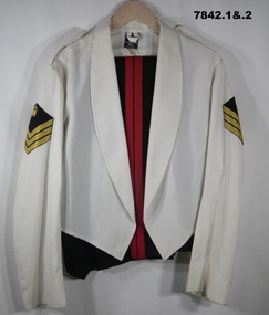
Uniform - MESS DRESS, ARMY, 1987
Uniform issued to S/SGT "Brian Thompson". Years of service 1973 - 1993. 316221.1. Jacket - white colour polyester/cotton fabric, rolled collar jacket, shoulder epaulettes, top of sleeves, black colour rank badge with gold colour crown and three stripes = Staff Sergeant. Manufacturers label back below collar. 2. Trousers - black colour cotton/polyester fabric with fob pocket and two side pockets. Metal and nylon zipper fly. Red colour wool fabric twin 2 cm stripe down each side seam. Manufacturers label back below waistband. Black colour polyester fabric lining waistband and pockets. Black plastic button inside waistband. 3. Cummerbund - Red colour polyester fabric, broad waist sash with three pleats, metal hook and bracket buckle and hook and loop fastener to adjust lengthy. Black colour polyester fabric lining. Manufacturers label. 4. Bowtie - black colour polyester fabric, pre-tied bow tie with metal clasp. Manufacturers label. 5. Braces - set of white colour cotton elastic braces with metal clips to attach to trousers. Metal slide clips to adjust length and plastic strap joiner.Manufacturers information. 1. Jacket - black fabric label - TETOROM/ 65% POLYESTER/ 35% COTTON/ WIMBLEDON WEAR/ MELBOURNE". White fabric label "97R/ WARM MACHINE WASH/ D NOT BLEACH/ MACHINE TUMBLE DRY/ WARM. WARM IRON." 2. "A.G.C.F./ VICTORIA/ 1987/ ^/ ARMY NO/ NAME" 3. "POLYESTER/ DRY/ CLEAN/ (50c) ONLY" 4. POLYESTER/ DRY/CLEAN/ (50c) ONLY"uniform, army, mess dress, brian thompson -
 Bendigo Military Museum
Uniform - JACKET AND TROUSERS, BATTLE DRESS, ARMY, Australian Defence Industries, 1953
"W.J.BERTUCH" SERVICE DETAILS - REFER CAT NO. 1664.2.1. Jacket - khaki colour, wool fabric, Battle dress style, belted at waist with metal buckle and brown plastic buttons. Collar, shoulder epaulettes, two front pockets with button down flap and sleeve cuffs. Shoulder insignia, white on red lettering "ROYAL AUSTRALIAN REGIMENT". Light khaki cotton twill fabric pocket lining. Manufacturers white fabric cotton labels. - Left pocket lining. Handwritten information. 2. Trousers - khaki colour wool fabric, Battle dress style, with two side pockets, two back pockets with concealed button down flap, one side leg pocket with concealed button down flap, button down belt loops on waist band, five button fly. Brown plastic buttons. Light khaki colour cotton twill lining to waist band and pockets. Manufacturers white cotton label, back waistband lining. Handwritten information. 3. Braces - type known as "POLICE AND FIREMEN". Set of cotton, flat elastic braces with leather button attachments for trousers. Stripes on elastic are brown, beige, blue, black and grey in colour. Metal slides for adjustment to wearers size. 1. & 2. Manufacturers information on labels. 1. Tw labels - black ink print - "Regimental NO./ NAME". Red ink print "M.T.X./ SIZE 3". Third cotton label - black ink print - all print indecipherable. Handwritten information - blue ink pen "PTE W.J. BERTUCH" 2. Black ink print "J. WILSON PTY LTD/ 1953/ SIZE 118/ MADE IN AUSTRALIA/ REGIMENTAL NO. / NAME". BLACK INK STAMP "?? - RO-SET" Handwritten information, blue ink pen "BERTUCH/ 59060". 3. Stamped on metal adjustment slides 'POLICE AND FIREMEN". Black ink stamp on leather F.B.??/ ^/ 1966/38.uniform, army, battle dress, w.j. bertuch -
 Bendigo Military Museum
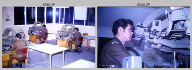
Photograph - Photographic Technicians operating the KLIMSCH Camera at the Army Survey Regiment, Fortuna, Bendigo, c1988
These nine photographs were most likely taken in c1988 in Lithographic Squadron at the Army Survey Regiment, Fortuna, Bendigo. The equipment operated by the technicians is the KLIMCH camera. The main tasks undertaken by the technicians were most likely enlargements and reductions of map reproduction material. The KLIMSCH Commodore camera was introduced in 1953 and was the largest in the Southern Hemisphere. It was replaced with a new model of the same size in 1979. The new model with its computer-based interface provided productivity gains with improved speed and its consistent results led to less wastage in time and materials. Its variomat lens system provided improved retention of map feature linear weights during the camera reduction process. The camera which was specially made for the Army in Germany was fully automatic and power operated. It was claimed to be one of the biggest automatic cameras of its type in the world. It was made to the specifications of the Royal Australian Army Survey Corps to assist in the production of the very high standard maps for the Army. There are several more photos catalogued in the Victorian Collections database of RA Svy personnel operating the KLIMSCH camera.This is a set of four photographs of technicians operating the KLIMSCH Camera at the Army Headquarters Survey Regiment, Bendigo c1988. The photographs are on 35mm colour slides scanned at 96 dpi. They are part of the Army Survey Regiment’s Collection. .1) - Photo, colour, c1988, KLIMSCH Camera. .2) - Photo, colour, c1988, KLIMSCH Camera, unidentified technician. .3) - Photo, colour, c1988, KLIMSCH Camera. .4) - Photo, colour, c1988, KLIMSCH Camera, L to R: SPR Shona Hastie, CPL Paul Baker. .5) - Photo, colour, c1988, KLIMSCH Camera. .6) & .7) - Photo, colour, c1988, KLIMSCH Camera, SPR Shona Hastie. .8) & .9) - Photo, colour, c1988, KLIMSCH Camera, SPR Russell Pajank.35mm colour slides are in good condition.rasvy, royal australian survey corps, army survey regiment, army svy regt, fortuna, asr, litho sqn -
 Bendigo Military Museum
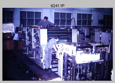
Photograph - Photo Troop Equipment, Lithographic Squadron – Army Survey Regiment, Fortuna, Bendigo, c1970s
... on the frame of the 35mm slides. This is a set of five photographs ...This collection of five photos was most likely taken at Lithographic Squadron, Army Survey Regiment, Fortuna, Bendigo in c1970s. The main tasks undertaken by technicians in Photo Troop were most likely enlargements, reductions and duplication of map reproduction material, and processing of aerial photography.This is a set of five photographs of Photo Troop equipment was taken in Lithographic Squadron, at the Army Survey Regiment, Fortuna, Bendigo, c1970s. The photographs are on 35mm colour slides and were scanned at 96 dpi. They are part of the Army Survey Regiment’s Collection. .1) - Photo, colour, c1970s, WILD U4A Diapositive Camera. .2) - Photo, colour, c1970s, Hass-Labortechnik Film and Paper Roller Transport Processor. .3) - Photo, colour, c1970s, Hass-Labortechnik Film and Paper Roller Transport Processor, SGT Christopher Wardley. .4) - Photo, colour, c1970s, Hass-Labortechnik Film and Paper Roller Transport Processor, unidentified technician. .5) - Photo, colour, c1970s, Pako Film Processor..1P to .5P – Some of the equipment is annotated on the frame of the 35mm slides.royal australian survey corps, rasvy, army survey regiment, army svy regt, asr, fortuna, litho -
 Bendigo Military Museum
Photograph - Retouching Reproduction Material at the Army Survey Regiment, Fortuna, Bendigo, c1975
... - There are no annotations stored with the 35mm slides. This is a set of seven ...This is a set of seven photographs of technicians retouching orthophoto reproduction material at the Army Survey Regiment, Bendigo, c1975. Retouching mainly entailed the application of liquid opaque (Plumtree), commonly known as “duff” to cover blemishes such as scratches and spots on film negatives before photographic exposure. Retouching technicians also used specialised techniques such as “needling” to repair faults on the emulsion of map reproduction material. The technicians in this set of photos were probably working on the retouching and registration of orthophotomap colour film separations in preparation for publication by Print Troop. Peter Dew featuring in photos .1P to .5P was a serving member of RA Svy, who died in a tragic accident at home. He was fondly remembered as one of Lithographic Squadron’s colourful personalities. The "Super Animal of the Year" Peter Dew Memorial Award was an award presented to a member of the squadron for a crude act. To view a photo of this award, refer to item 6230 of the Victorian Collections.This is a set of seven photographs of technicians retouching and assembling orthophoto reproduction material at the Army Survey Regiment, Fortuna, Bendigo. c1975. The photographs are on 35mm colour slides and were scanned at 96 dpi. They are part of the Army Survey Regiment’s Collection. .1) to .3) - Photo, colour, c1975. Retouching reproduction material. L to R: SPR Ralph Chant, PTE Laurie Tedford, SGT Peter Dew. .4) to .5) - Photo, colour, c1975. Retouching reproduction material. SGT Peter Dew. .6) - Photo, colour, c1975. Assembly of orthophoto colour film separations. .7) - Photo, colour, c1975. Assembly of orthophoto colour film separations, CPL Garran Hill..1P to .7P - There are no annotations stored with the 35mm slides.royal australian survey corps, rasvy, army survey regiment, army svy regt, fortuna, asr, litho -
 Bendigo Military Museum
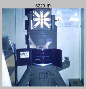
Photograph - Photogrammetric Equipment – Army Survey Regiment, Bendigo and School of Military Survey Bonegilla, c1960s to c1980s
This is a set of 14 photographs of RA Svy technicians operating photogrammetric equipment in Air Survey Squadron, Army Survey Regiment, Fortuna, Bendigo; and the School of Military Survey Bonegilla c1960s to c1980s. The Wild B9 stereo plotter were introduced in 1962 and the Wild B8 stereo plotter was introduced in 1966. The Wild B9 and B8 stereo plotters were used for plotting topographic detail and contours. These analogue machines were manually controlled by adjusting the control knobs for the orientation of the 3D image. The B9s used a four and a half square, and the B8s used a nine-inch square photo image on a film or glass diapositive which allowed highly accurate extraction of map features. At first, plotting with B8 and B9 stereo plotters was undertaken at the aerial photography scale of 1:80,000 in pencil onto a controlled plotting sheet. Sheets were then inked up and reduced photographically to the 1: 100,000 publication scale for scribe impression production. In the early days topographic detail and contours were plotted with a pencil or ink pen mounted at the far end of the pantograph arm. The plotting procedure was upgraded to direct plotting in ink with photographic reduction to publication scale. In 1975 four B8s were upgraded with tri-axis locaters as part of the Input Sub-system to enable digital extraction to AUTOMAP 1’s topographic database. When AUTOMAP 2 was introduced in 1982 these B8s were upgraded, and additional machines added to expand the Army Survey Regiment’s digital capture capability. There are several more photos catalogued in the Victorian Collections database of RA Svy personnel operating Wild B9 and B8 stereo plotters.Photogrammetric Equipment – Army Survey Regiment, Fortuna, Bendigo c.1981. . .7) – Unidentified technician operating Wild B8 stereo plotter in AUTOMAP 1 at ASR. .8) - Wild B8 stereo plotter in AUTOMAP 1 at ASR. Photogrammetric Equipment – Army Survey Regiment, Fortuna, Bendigo. c1981. .9) – ASR’s CPL Dave Cook in AUTOMAP 1 operating a Wild B8 stereo plotter. This is a set of 14 photographs of RA Svy technicians operating photogrammetric equipment at the Army Survey Regiment (ASR), Bendigo and the School of Military Survey (SMS) Bonegilla. c1960s to c1980s. The photographs are on 35mm colour slides and were scanned at 96 dpi. .1) - Photo, colour, c1964. Unidentified ASR technicians operating analogue Wild B9 stereo plotters. .2) - Photo, colour, c1974. ASR’s SPR Mick Minchin operating an analogue Wild B8 stereo plotter. .3) to .6) - Photo, colour, c1980. Photogrammetry Instructor SGT Neil ‘Ned’ Kelly at the SMS operating an analogue Wild B8 stereo plotter. .7) - Photo, colour, c1981. Unidentified technician operating Wild B8 stereo plotter in AUTOMAP 1 at ASR. .8) - Photo, colour, c1981. Wild B8 stereo plotter in AUTOMAP 1 at ASR. .9) to .14) - Photo, colour, c1981. ASR’s CPL Dave Cook in AUTOMAP 1 operating a Wild B8 stereo plotter..1P to .14P - Some of the equipment is annotated on the frame of the 35mm slides.royal australian survey corps, rasvy, army survey regiment, army svy regt, fortuna, asr, photogrammetry -
 Bendigo Military Museum
Photograph - Print Troop Equipment and Personnel, Lithographic Squadron – Army Survey Regiment, Fortuna, Bendigo, c1970s to 1980s
... - There are no annotations stored with the 35mm slides. This is a set of nine ...This collection of nine photos was most likely taken in Lithographic Squadron, Army Survey Regiment, Fortuna, Bendigo, c1970s to 1980s. The two Ultra-MAN-III Printing Presses were made in Germany at a standard map size format and introduced in June 1962 as a two-colour offset press with improved safety features. With an upgrade to a third colour deck in 1968, productivity greatly improved as the two presses could print a five-colour standard topographic map in two passes, rather than the three passes before their upgrade. They were replaced with a single Heidelberg Speedmaster 102 five colour Printing Press in 1990. There is more information on the Ultra-MAN-III, Printing Press on page 71 of Valerie Lovejoy’s book 'Mapmakers of Fortuna – A history of the Army Survey Regiment’ ISBN: 0-646-42120-4. For additional photos, refer to item 6065.10P for Ultra-MAN-III presses. The Krause Wohlenberg in photo .5P was a heavy-duty guillotine to trim bulk printed map stock in the c1970s and c1980s. See item 6069.6P for more information and photos of guillotine equipment. Densitometer readings as shown in photo .6P were essential to the quality control of film and printing processes, reductions in time taken and material wastage.This is a set of nine photographs of Print Troop personnel and equipment from Lithographic Squadron at the Army Survey Regiment, Fortuna, Bendigo, c1970s to 1980s. The photographs are on 35mm colour slides and were scanned at 96 dpi. They are part of the Army Survey Regiment’s Collection. .1) - Photo, colour, c1970s, Ultra-MAN-III Printing Presses, L to R: unidentified technician, Laurie Sutton, SGT Jim Cook, unidentified technician. .2) - Photo, colour, c1970s, Ultra-MAN-III Printing Presses, unidentified technicians (x2). George Mann Fast Five Quad Demi Printing Press in background. .3) - Photo, colour, c1970s, Ultra-MAN-III Printing Presses, unidentified technicians (x2), George Austen in background and George Mann Fast Five Quad Demi Printing Press next to back wall. .4) - Photo, colour, c1970s, Ultra-MAN-III Printing Press, unidentified technicians (x2) operating George Mann Fast Five Quad Demi Printing Press in background. .5) - Photo, colour, c1970s, Krause Wohlenberg heavy-duty paper guillotine, unidentified technician. .6) - Photo, colour, c1970s, Densitometer reading taken by unidentified technician. .7) - Photo, colour, c1980s, Ultra-MAN-III Printing Presses, L to R: Janet Murray, Lance Strudwick, Terry Winzar, Komori Newkoni and Planeta Polygraph Printing Press in background. .8) to .9) - Photo, colour, c1980s, Ultra-MAN-III Printing Presses, Janet Murray, Komori Newkoni and Planeta Polygraph Printing Presses in background..1P to .9P - There are no annotations stored with the 35mm slides.royal australian survey corps, rasvy, army survey regiment, army svy regt, fortuna, asr, printing, litho -
 Bendigo Military Museum
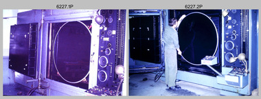
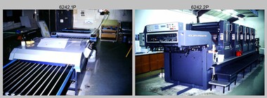
Photograph - Print Troop Equipment, Lithographic Squadron – Army Survey Regiment, Fortuna, Bendigo, c1990s
... with the 35mm slides. This is a set of 25 photograph of Print Troop ...This is a set of 25 photograph of Print Troop Equipment in Lithographic Squadron, Army Survey Regiment at Fortuna, Bendigo, 1990. Photo .1P features the new Howson Algraphy Autoneg printing plate processor. It improved quality control and efficiency and allowed the conversion of printing plates for positive or negative use. The Heidelberg Speedmaster 102 shown in photos .2P to .4P was a computer-controlled five colour lithographic offset printing press. It provided the Royal Australian Survey Corps a vastly improved printing capability, as the five colours for a standard topographic map was printed in a single pass. The print room housing the Speedmaster printing press was named Wayzgoose Hall after a medieval printing house festival. Wayzgoose Hall and the Speedmaster printing capability was commissioned by the Commander of the 3rd Military District BRIG P. Davies AM, ADC on Wednesday 27th June 1990. This occasion is covered in more detail in page 145 of Valerie Lovejoy’s book 'Mapmakers of Fortuna – A history of the Army Survey Regiment’ ISBN: 0-646-42120-4. For additional photos, refer to item 6062.4P for more photos of the Heidelberg Speedmaster printing press. The Print Room’s Map Assessment and Colour Evaluation Stations in photos .5P to .12P provided the Printer Technician suitable viewing environments to perform quality assessments of map samples. See item 6151.34P for more information and photos of technicians using the equipment. The Print Room’s Map Handling Station in photo .15P to .20P provided ergonomic benefits to the Printer Technician and improved despatching productivity. See Item 6070.9P for more information and photos. The Wohlenberg MCS-2 guillotine seen in photos .21P & .22P was a heavy-duty guillotine integrated component of the Map Handling Station, to trim bulk printed map stock. See item 6069.6P for more information and photos of earlier types of guillotine equipment. This is a set of 25 photograph of Print Troop Equipment in Lithographic Squadron, Army Survey Regiment at Fortuna, Bendigo, 1990. The photographs are on 35mm colour slides and were scanned at 96 dpi. They are part of the Army Survey Regiment’s Collection. .1) - Photo, colour, c1990s, Howson Algraphy Autoneg printing plate processor .2) to .4) - Photo, colour, 1990. Heidelberg Speedmaster 102 computer-controlled five colour lithographic offset printing press .3) to .10) - Photo, colour, c1990s, Heidelberg Speedmaster CPC 1-04 control unit. .11) to .12) - Photo, colour, c1990s, Map Colour Evaluation Work Station. .13) to .14) - Photo, colour, c1990s, Linear printing plate registration punch. .15) to .20) - Photo, colour, c1990s, Print Room’s Map Handling Station. .21) to .22) - Photo, colour, c1990s, Wohlenberg MCS-2 guillotine. .23) - Photo, colour, c1990s, Print Room Power supply equipment. .24) to .25P - Photo, colour, c1990s, Print Room Crown Fork Lift..1P to .25P - There are no annotations stored with the 35mm slides.royal australian survey corps, rasvy, army survey regiment, army svy regt, fortuna, asr, printing, litho -
 Bendigo Military Museum
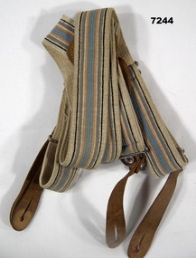
Uniform - BRACES
... Braces Kevin John HERDMAN Stamped on metal adjustment slides ...Part of the KEVIN JOHN HERDMAN, No. 397661 Collection. See cat No. 5942P for details of his service record.Set of cotton, elastic braces with brown leather button attachments for trousers. Stripes on elastic are black, brown, grey, orange and blue in colour. Metal slides for adjustment to "wearers" size.Stamped on metal adjustment slides; "POLICE AND FIREMEN".uniform, braces, kevin john herdman -
 Bendigo Military Museum
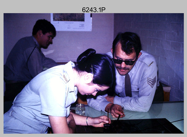
Photograph - Tasks Demonstrated by Royal Australian Survey Corps Technicians, c1990s
This is a set of 17 photographs of technicians from the Royal Australian Survey Corps undertaking technical tasks circa 1990s. Photos .1P to .9P were taken at the Army Survey Regiment, Fortuna, Bendigo. Photos .10P to .15P and .17P of students operating survey equipment, were taken at the School of Military Survey, Bonegilla and survey stations surrounding Lake Hume. The base camp at photo .16P was probably taken at Sandy Creek, near Tallangatta Victoria, during the field phase of a basic or advanced RA Svy training course. CPL Steve Nokes appearing in photo .17P was attending the 1/90 Map Control Survey Course.This is a set of 17 photographs of technicians from the Royal Australian Survey Corps undertaking technical tasks at the Army Survey Regiment, Fortuna, Bendigo, and the School of Military Survey, Bonegilla c1992. Colour photos are on 35mm slide film and were scanned at 96 dpi. Photo .17P is in black & white, printed on photographic paper and scanned at 300 dpi. The photos are part of the Army Survey Regiment’s Collection. .1) – Photo, colour, c1992, Aerial photography Assessment, SGT Tony Grivell. .2) – Photo, colour, c1992, Aerial photography Assessment, L to R: WO2 Noel McNamara and LCPL Grant Lloyd. .3) – Photo, colour, c1992, Wild PUG4 point transfer device, LCPL Mark Fedden. .4) – Photo, colour, c1992, AUTOMAP 2 Graphic Edit Workstation, unidentified technician. .5) – Photo, colour, c1992, Heidelberg Speedmaster 102 computer-controlled five colour lithographic offset printing press, CPL Nick Vanderzwan. .6) – Photo, colour, c1992, Daylight film contact frame, SPR Ken Labourchardiere. .7) – Photo, colour, c1992, Heidelberg Speedmaster 102 Map Colour Evaluation Workstation, SGT Stuart Ridge. .8) – Photo, colour, c1992, Map proof evaluation, CPL John Bragg. .9) – Photo, colour, c1992, Wohlenberg MCS-2 guillotine, unidentified technician. .10) – Photo, colour, c1992, Wild T2 Theodolite, L to R: SPR Matt Arnold, SPR Kim Baker. .11) – Photo, colour, c1992, Wild T2 Theodolite, L to R: SSGT Bob Bright, SPR Kim Baker. .12) to .14) – Photo, colour, c1992, MRA-7 Tellurometer, CPL Mark Bourne. .15) – Photo, colour, c1992, Plane Tabling, CPL Mark Bourne. .16) – Photo, colour, c1992, School of Military Survey base camp, Sandy Creek, VIC. .17) – Photo, black & white, 1990, MRA-7 Tellurometer, CPL Steve Nokes. .1P to .16P - There are no annotations. .17P – annotated on back ‘CPL NOKES WITH MRA7 ON 1/90 MAP CONTROL COURSE’royal australian survey corps, rasvy, army survey regiment, army svy regt, school of military survey, fortuna, asr -
 Bendigo Military Museum
Photograph - Johnson Ground Elevation Meter (JGEM) Survey Vehicle - Army Survey Regiment, Fortuna, Bendigo, c1960s
... on the frame of the 35mm slides. This is a set of 16 photograph ...This is a set of 16 photograph of the Royal Australian Survey Corps’ Johnson Ground Elevation Meter (JGEM) Survey Vehicle taken at the Army Survey Regiment, Fortuna, Bendigo. The JGEM vehicle was extensively used by RA Svy within Australia from the late 1960s. A limited number of Ground Elevation Meter (GEM) station wagon type vehicles were manufactured by General Motors Corporation (GMC) in the USA for the United States Geological Survey, Canada’s mapping agencies, RA Svy and National Mapping (Natmap). The GEM was a four-wheel drive, four-wheel steer vehicle. Four-wheel steering was necessary to avoid systematic errors caused by non-tracking of front and rear wheels on conventionally steered vehicles. The manufacturer substituted the rear axle with a front axle and connected them to form the four-wheel steering mechanism. The two Australian GEM vehicles, referred to as Johnson GEMs (JGEMs) were converted into right-hand drive. After delivery in 1964, acceptance Natmap and RA Svy testing and operator training was undertaken at the Army's School of Military Survey located at Balcombe, Victoria. A small fifth wheel was mounted on a cantilever arm suspension midway between the front and rear wheels on the right side of the vehicle. It was lowered to and raised from its operating position by use of a constant pressure air cylinder. A telescopic bar, suspended between the front and rear axles, provided the reference datum for the angle measurement. The wheel provided the velocity or distance signal through a pulse generator system. A sensitive pendulum mounted on this bar provided the angle measurement for each minute distance traversed. The JGEM contained electromechanical instruments used to determine relative elevations, by trigonometric principles, along a traversed path. These relative elevations were obtained through apparatus which measures the instantaneous angle of inclination of the road and the instantaneous velocity of the meter along such a path. Road routes over which the JGEM operated were planned so that each started and ended as near as practicable to an existing point of known elevation (formally referred to as a level traverse bench mark). The difference in height from the bench mark and the road surface alongside the JGEM’s fifth wheel was measured with a level and staff. Along each route, mapping control photo reference points where new elevation values were required were identified on aerial photographs. Under favourable conditions it was possible to survey as much as 160km in an ordinary working day. The first of RA Svy’s JGEM operations was undertaken in 1:250,000 scale map areas of Queensland. CPL John Hook was the JGEM’s main operator in the early 1970s undertaking operations covering 1:250,000 scale map blocks over northern Victoria and central NSW, each requiring 36 points (9 runs of photography and 4 points across. SPR Lyn Thompson and SPR Bob McDonagh teamed with CPL Hook on some of these JGEM operations. When RA Svy was integrated into the Royal Australian Engineers in 1996, the JGEM vehicle with the Survey Corps collection was donated to its museum. It is believed to be the last of the original manufactured fleet in existence. The JGEM has undergone extensive refurbishment to achieve roadworthiness and is currently housed at The Australian Army Museum of Military Engineering, Hoslworthy Barracks, NSW. It can be viewed by making an appointment with the museum’s curator.This is a set of 16 photograph of the Royal Australian Survey Corps’ Johnson Ground Elevation Meter (JGEM) Survey Vehicle taken at the Army Survey Regiment, Fortuna, Bendigo. The photographs were on 35mm slide film and were scanned at 96 dpi. They are part of the Army Survey Regiment’s Collection. .1) - Photo, colour, c1960s, Johnson Ground Elevation Meter (JGEM) Survey Vehicle .2) - Photo, colour, c1960s, JGEM instrumentation, on-board computer. .3) - Photo, colour, c1960s, JGEM instrumentation. .4) - Photo, colour, c1960s, JGEM instrumentation, on-board computer. .5) - Photo, colour, c1960s, JGEM tyre pressure controller .6) - Photo, colour, c1960s, JGEM rear doors, SGT Geoff Briggs. .7) - Photo, colour, c1960s, JGEM 5th wheel distance/angle measurement device in lowered position, SGT Geoff Briggs. .8) - Photo, colour, c1960s, JGEM 5th wheel distance/angle measurement device in lowered position. .9) & .10) - Photo, colour, c1960s, JGEM tyre pressure system, SGT Geoff Briggs. .11) - Photo, colour, c1960s, JGEM tyre pressure system. SGT Geoff Briggs. .12) - Photo, colour, c1960s, JGEM levelling scope, levelling staff, unidentified technicians. .13) & .14) - Photo, colour, c1960s, JGEM levelling scope, unidentified technician. .15) & .16) - Photo, colour, c1960s, probably survey operation adjusted height plotted on block base sheet. .1P to .16P - Some of the equipment is annotated on the frame of the 35mm slides.royal australian survey corps, rasvy, army survey regiment, army svy regt, fortuna, asr, surveying -
 Bendigo Military Museum
Photograph - Cartographic Production – Army Survey Regiment, Fortuna, Bendigo, c1960 -1975
... with the 35mm slides. This is a set of 10 photographs of cartographic ...This is a set of 10 photographs of Cartographic Squadron technicians undertaking map production tasks in at the Army Survey Regiment, Fortuna, Bendigo circa 1968 to 1975. Production was undertaken on the top floor of Fortuna Villa. The Fotosetter type setting machine shown in photos .1P and .2P. replaced the letterpress method of type production in 1956. CPL Arty Lane specialised in the operation of the Fotosetter type setting machine for many years. For more information on the Fotosetter, see page 71 of Valerie Lovejoy’s book 'Mapmakers of Fortuna – A history of the Army Survey Regiment’ ISBN: 0-646-42120-4. The computer based Editwriter Model 7500 typesetting system shown in photos .3P and .4P. was introduced in 1975 as a replacement to the aging Fotosetter. It was operated by a specialised technician, who generated a large variety of map type styles and sizes quickly and reliably, as well as text panels. Output on Copy proof adhesive backed stripping type film replaced messy wax and spray adhesives in 1978. The Editwriter capability supported all RASvy units and its contractor type setting requirements. The Aristo Co-ordinatorgraph shown in photos .5P to .7P was introduced in 1962. It was a large heavy steel framed light table with a scribing head that moved in a XY direction using a vernier calibrated measuring scale to 0.001 of an inch. Whilst hand operated it was much quicker and accurate than manual grid and graticule calculation, plotting and scribing. The history of co-ordinatorgraphs is covered in more detail with additional historic photographs, in pages 50 to 51 and page 88 of Valerie Lovejoy’s book 'Mapmakers of Fortuna – A history of the Army Survey Regiment’ ISBN: 0-646-42120-4. The scribing process as shown in photos .8P to .9P was the cartographic process of drafting features such as drainage, relief, vegetation, roads and culture on specially coated map reproduction material. The cartographic technician scribed out the map feature such as a contour to a specified line width on the map sheet, using a tool affixed with a sapphire tipped cutter. The quality control edit (Proving) stage of map production shown in photo .10P was the first opportunity to independently and systematically inspect a proof of the map.This is a set of 10 photographs of cartographic Squadron technicians undertaking map production tasks at the Army Survey Regiment, Fortuna, Bendigo, c1968 to c1975. The photographs were on 35mm colour slides and scanned at 96 dpi. They are part of the Army Survey Regiment’s Collection. .1) to .2) - Photo, colour, c1968, Fotosetter type setting machine, CPL Arty Lane. .3) to .4) - Photo, colour, c1975, Typesetting machine, ‘Editwriter’ Model 7500. .5) - Photo, colour, c1960s, PTE Desi Asaris and CPL Kalen Sargent operating Aristo Co-ordinatorgraph equipment. .6) - Photo, colour, c1970s, L to R: CPL Desi Asaris, CPL John Bennett, operating Aristo Co-ordinatorgraph equipment. .7) - Photo, colour, c1970s, L to R: CPL John Bennett, CPL Desi Asaris operating Aristo Co-ordinatorgraph equipment. .8) - Photo, colour, c1970s, L to R: CPL Desi Asaris scribing drainage, CPL John Bennett. .9) - Photo, colour, c1970s, CPL Desi Asaris scribing drainage. .10) - Photo, colour, c1970s, L to R: CPL Desi Asaris, CPL John Bennett and their supervisor WO2 Roger Rix inspecting features on an aeronautical chart proof. .1P to .10P There are no annotations stored with the 35mm slides.royal australian survey corps, rasvy, army survey regiment, army svy regt, fortuna, asr, carto -
 Kiewa Valley Historical Society
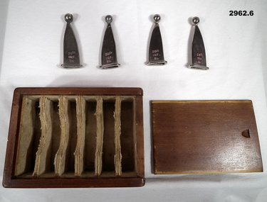
Rubber Stamps - Educational
Educational aidsMt Beauty and Bogong Primary Schools were well equipped with educational aidsWooden box containing 94 rubber stamps, 1 illustration sheet, 1 advertising sheet regarding the set and 4 metal trays holding the stamps. The box has a sliding 'door'. Inside are the trays, stamps outlining eg. transport, animals Logo and 2 black and white sheets. Paper blue, yellow and white logo glued to the top of the box "D.O.Smith at top and Educational Picture Maker" beneath forming a circle on the circumference with a picture of a large ship in the centre.mt beauty primary school, bogong primary school, rubber stamps, educational aid, d.o. smith, educational picture maker -
 Eltham District Historical Society Inc
Slide - Photograph, Unidentified artwork; stained glass leadlight
Unidentified artworks35mm colour positive transparency (21) Mount - Kodak Ektachrome Blue Verycolour MelbourneIn a box marked Set B Norm. LHS RHSleadlight, stained glass, artwork -
 Eltham District Historical Society Inc
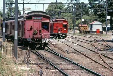
Photograph, Hurstbridge bound two coach set (Red Rattler) Tait Sunday service train departs Eltham Station, c. January 1983, 1983
Rarely used two coach set (usually single car)Digital TIFF file Scan of 35mm Kodachrome colour positive transparency in cardboard slide mount.Processing date Jan 1983?eltham railway station, george coop collection, red rattler, single carriage train, single motor carriage, tait train -
 Eltham District Historical Society Inc
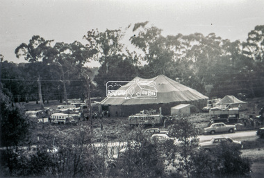
Slide - Photograph, Grace Mitchell, Ashtons Circus set up in Bremner's Reserve, Main Road, Eltham, c.1955
View from Grace Mitchell's shop at the corner of Mount Pleasant Road and Main Road. Grace Mitchell was probably best known for her Eltham shop at the corner of Mt Pleasant Road and Main Road. Grace's memories covered many local identities who were patrons of her shop between 1954 and 1971. From the elevated position of her shop and home Grace was able to view a varied passing parade of Eltham events from ERSILAC, Easter and Eltham Festival parades passing on their way to Eltham Lower Park, circuses in Wingrove Park (then Bremner’s Reserve), roadworks and other happenings. Bremner's Reserve was renamed Wingrove Park c.1970 This photo was from a series of images presented by Grace Mitchell at a Society talk 10 March 1993 on the theme of “My Eltham”.35mm Kodak 5052 TMX Black and White transparency, 1 strip, 6 frames Black and white print 17 x 25.4 cmashtons circus, bremner's flat, circus, grace mitchell, main road, mount pleasant road, wingrove park -
 Eltham District Historical Society Inc
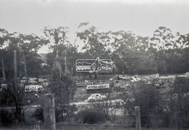
Slide - Photograph, Grace Mitchell, Ashtons Circus set up in Bremner's Reserve, Main Road, Eltham, c.1955
View from Grace Mitchell's shop at the corner of Mount Pleasant Road and Main Road. Grace Mitchell was probably best known for her Eltham shop at the corner of Mt Pleasant Road and Main Road. Grace's memories covered many local identities who were patrons of her shop between 1954 and 1971. From the elevated position of her shop and home Grace was able to view a varied passing parade of Eltham events from ERSILAC, Easter and Eltham Festival parades passing on their way to Eltham Lower Park, circuses in Wingrove Park (then Bremner’s Reserve), roadworks and other happenings. Bremner's Reserve was renamed Wingrove Park c.1970 This photo was from a series of images presented by Grace Mitchell at a Society talk 10 March 1993 on the theme of “My Eltham”.35mm Kodak 5052 TMX Black and White transparency, 1 strip, 6 frames Black and white print 17 x 25.4 cmashtons circus, bremner's flat, circus, grace mitchell, main road, mount pleasant road, wingrove park -
 Bendigo Military Museum
Photograph - Royal Australian Survey Corps Aerial Surveys, c1980
This is a set of nine photographs of technicians from the Royal Australian Survey Corps operating aerial surveys equipment c1980s. In photo .1P, CPL Steve Gloster was operating a RC10 air survey camera mounted in an Australian Army Pilatus Porter aircraft. The Wild RC10 super wide-angle air survey cameras were first introduced in 1971, were equipped with virtual distortion free lenses for supplementary, spot and special photography. In photo .2P, Roger Rees was operating Air Profile Recorder (APR) equipment. it was possibly taken during OP NERVOSE 84, sometime between June – August 1984 when based in Ngukurr, Northern Territory. The APR was operated at this time in unison with an RC10 camera. In 1963 the Royal Australian Survey Corps introduced the radar airborne profile recorder (Canadian Applied Research Ltd, Mark V, Airborne Profiler Recorder) was introduced for 1:100,000 mapping to replace terrain heighting by aneroid barometry. Later in 1974-1975, the Australian developed WREMAPS II airborne laser terrain profile recorder was introduced. In photo .3P, Neil Jones appears at the door of Airsearch Beechcraft Queen Air aircraft, Registration / Serial VH-MWX. This aircraft was typically used by RA Svy on air survey operations flying mission with Aerodist, APR and RC10 camera equipment. The Australian Army’s Pilatus Porter (short take-off and landing turbo propeller) was also equipped with a Wild RC10 aerial mapping camera for identification photography. The Pilatus Porter was also used on RA Svy’s map field checking operations. Photo .9P was taken at a survey station at an unknown location. In this photo an Australian Army Kiowa Light Observation Helicopter (LOH) is supporting a field survey party undertaking Magnavox AN/PRR-14 portable Doppler satellite observations. The satellite receiver’s antenna is plumbed over the survey ground mark surrounded by white plastic panels. The panels were used to identify the survey station on aerial photography. Introduced in 1974–1975, the Magnavox AN/PRR-14 portable Doppler satellite (US Navy Navigation Satellite System – TRANSIT) receivers and computing system provided independent three-dimensional point positions anywhere in the world, anytime, in any weather accurate to about 1.5metres with precise satellite ephemerides. The Bell OH-58 Kiowa LOH was a family of military helicopters used for observation, utility, and direct fire support. It was identified by RA Svy in the mid-1970s that considerable time was lost in replacing unserviceable remote equipment by road. Therefore Aerodist operations (pre-dating satellite receiver operations) were fully supported by Army’s Kiowa LOH aircraft. This is a set of nine photographs of technicians from the Royal Australian Survey Corps operating aerial surveys equipment c1980s. .1P to .3P, .5P to .9P - Colour and black and white photos on photographic paper and scanned at 300 dpi. .4P - Colour photo on 35mm slide film and scanned at 96 dpi. .1) & .2) - Photo, black & white, c1980s, CPL Steve Gloster operating an RC10 air camera. .3) - Photo, colour, 1984, Roger Rees operating Air Profile Recorder (APR) equipment. .4) - Photo, colour, c1980s, Neil Jones at the door of an Airsearch Beechcraft Queen Air aircraft, typically used by RA Svy on air survey operations. .5) - Photo, colour, c1980s. A Beechcraft King Air aircraft, also used by RA Svy on air survey operations. .6) - Photo, colour, c1980s. An Australian Army Pilatus Porter, used by RA Svy on air survey and map field checking operations. SGT Peter Mustart is possibly in the foreground. .7) to .8) - Photo, colour, c1980s. An Australian Army Pilatus Porter and unidentified personnel, used by RA Svy on air survey and map field checking operations. .9) - Photo, colour, c1980s. An Australian Army Kiowa helicopter supporting a field survey party undertaking Magnavox AN/PRR-14 portable Doppler satellite observations. There are biro marks on photos .4P to .9Proyal australian survey corps, rasvy, army survey regiment, asr, fortuna, aerial surveys -
 Bendigo Military Museum
Accessory - BAYONET TIPS, Post WW1
Set (4 of 6, 2 missing) ceremonial bayonet tip covers. .1) Wooden box, varnished brown, padded internal dividers. .2) Wooden, sliding type lid. .3) - .6) Chromed bayonet tip cover with a 12 mm sphere at tip..3) - .6) Stamped with traces of red paint, both sides of tip covers: “38th Inf Bn” Sticky label on box side: 26.military equipment - army, bayonet, passchendaele barracks trust -
 Bendigo Military Museum
Equipment - WEBBING SET, C.1960’s
.1 Pattern 56 army pack jungle green canvas. Has straps, buckles. Shoulder straps with quick release catches. .2 Belt pattern 56 army. slides and buckle clips, jungle green. .3 Carrier with bottle pattern 56 - jungle green cotton canvas with clips. .4 Carrier water bottle pattern 56 - jungle green cotton canvas with clips. .5 Water bottle plastic 1 litre green. .6 Water bottle plastic 1 litre green.Pack has written on front ? The word "home" written on name tag patch. .3 Back has O'HAIRE. Front has 69 .5 Has HALL. F. 2309252 written on it. .6 Has a cardboard tag with PETER BARKER written on it.webbing, back packs, equipment -
 Flagstaff Hill Maritime Museum and Village
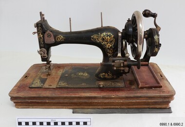
Domestic object - Sewing Machine, 1890s to 1911
This machine was made in Baden, Germany, for the Ward Brothers of Melbourne, who imported machines from various manufacturers and had them branded with their Ward Brothers decals. This machine is most likely dated before 1911, when the Ward Brothers became two separate businesses, as one of the decals appears to have been deliberately removed. The case is made in an attractive design and the machine itself has decorations that are pleasant to the eye. Even the metal cover of the folding handle has a swirling design on it. The machine has the added bonus of a ruler along the front base. Many sewing machine manufacturers in Germany produced their machines specifically for export. A company could mass-produce its machines and give the same product several different brand names, according to their overseas buyers. There was a huge market for domestic machines as it enabled tailored clothing to be made in households at a fraction of the retail prices. Ward Brothers began in Australia in the late 1890s and early sewing machines sold by them had the three brothers on their decals. In 1911 the brothers divided into two separate firms, one operating on his own, the other two remaining together, and all still operating in Melbourne and at first still using the name Ward Brothers.This sewing machine is one of two hand-operated Ward Brothers machines in our collection that were made in Baden, Germany, and the only one that has had the three Ward Brothers on its decal, and that has front and rear slide plates. This machine represents the early domestic market for sewing machines, making it possible for the everyday homemaker to produce fashionable garments and linen ware that was affordable. The owner of this machine could work at more than one location as it was portable and did not require a large space to set up. The machine is associated with the well-known Ward Brothers of Melbourne, who sold imported sewing machines that were branded with their own name. Sewing machine, hand operated, in wooden case. The machine is painted black with gold decals, and front and rear slide plates. The wooden base of the machine has an inlaid ruler. The case has curved sides and shaped ends, decorative woodwork on corners, an inlaid diamond pattern on top, and a folding metal handle. Accessories are included. The decals include doves, inscriptions and swirls, and there is a map of Australia with two portraits of men. The machine was made in Baden, Germany, for Ward Brothers, Melbourne. Images: Map of Australia with States marked, and with portraits of two men. [A portrait-sized area on the left of the men has had the image removed.] Text in printed script: "Specially / Made in Baden" "WARD BROTHERS / MELBOURNE" " with a Logo is a map of Australia,flagstaff hill, warrnambool, great ocean road, sewing machine, hand operated, pre-1911, domestic sewing, homemade clothing, fashion, ward brothers, made in germany, baden, front and rear slide plates, crank handle, hand crank sewing machine