Showing 93 items
matching standard measure
-
 Flagstaff Hill Maritime Museum and Village
Equipment - Lead line
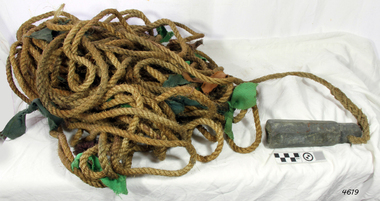
The lead line or hand lead is a simple navigational instrument used as a depth finder to measure the depth of water under the ship’s keel and to take samples of the sea bed. The long line may be marked at regular intervals with tags of different coloured and textured fabric, such as rope, leather and cloth. Each tag was a code to represent a certain depth. The leadsman’s eyes and hands could distinguish the depth easily as he drew in the lead line, day or night and in poor weather conditions. A standard set of codes for the tags was used so that the depth of the sea could be easily and quickly read. The measurement used was a Fathom, which equals 1.83 metres. The codes were: - 2 fathoms = 2 strips of leather 3 fathoms = 3 strips of leather 5 fathoms = white duck fabric 7 fathoms = red bunting fabric 10 fathoms = leather with a hole 13 fathoms = blue serge fabric 15 fathoms = white duck fabric 17 fathoms = red bunting 20 fathoms = 2 knots The lead weight could be between 7 -14 pounds (3.5 – 6.5kg) and the rope would be approximately 25 fathoms (45m). The hollowed-out end of the weight would hold a stick substance such as tallow or wax, which would pick up samples from the sea bed which would show whether the vessel was close to, or far away from, the shore. The leadsman would stand at the front of the vessel and cast the lead line into the sea. When it hit bottom he would note the tag marker nearest the surface of the water and call out his finding. Then he would haul it up again and examine the kind of matter that adhered to the end of the weight, whether it be sand, mud, gravel, or the colour of it. This information would be given to the ship’s helmsman or navigator and would help indicate the proximity to the land.This handheld lead is an example of early marine navigational equipment used by sailors to travel the seas to measure the depth of the water and sample the nature of the seabed. It helps to understand the history and progress made from the very basic to the sophisticated technology of today.Lead line, sounding line or depth finder. The long length of rope has a heavy lead weight attached to the end. Coloured fabric tags are tied onto the rope at regular intervals, representing different depths. The concave base of weight holds sticky substances such as tallow or beeswax, providing an adhesive surface to collect samples of sea bed like sand, shells or pebbles. flagstaff hill, warrnambool, shipwrecked coast, flagstaff hill maritime museum, maritime museum, shipwreck coast, flagstaff hill maritime village, lead line, depth finder, hand lead, sounding lin, leadsmane, navigation instrument, leadline, hand lead line -
 Bendigo Military Museum
Administrative record - Royal Australian Survey Corps - 1st, 2nd and 3rd Order Triangulation Precis, School of Military Survey, Balcombe, Circa 1948 - 1960
A School of Military Survey Precis, 8 x foolscap sized pages of typed text, stapled and two hole punched. The precis No 3 covers the Observation procedure to be used for 1st, 2nd and 3rd Order Triangulation using the Royal Australian Survey Corps standard Cooke, Troughton and Simms Tavistock or Wild T2. The geodetic model Tavistock with a 5.25" horizontal circle should be used for 1st Order Triangulation and maybe used for 2nd Order Triangulation if specially directed. The standard Tavistock with 3.5" horizontal circle or the Wild T2 should be used for 2nd and 3rd Order observations. The Precis discusses the types of errors, the source of errors and the best ways of managing them. In surveying, triangulation is the process of determining the location of a point by measuring only angles to it from known points at either end of a fixed baseline by using trigonometry, rather than measuring distances to the point directly as in trilateration.A School of Military Survey Precis, 8 x foolscap sized pages of typed text, stapled and two hole punched.royal australian survey corps, rasvy, fortuna, army survey regiment, army svy regt, asr, school of military survey, sms, balcombe -
 Flagstaff Hill Maritime Museum and Village
Book - Reference, navigation, The Seaman and Merchants Complete Expeditious Measurer, 1857
This reference book would be used by sea merchants when trading in cargo.The book is significant for its association with reference information for sea merchant traders. Book, tall and narrow, with index tabs on the side edges of the pages. FULL Title: The Seaman and Merchants Complete Expeditious Measurer: The Seaman and Merchants Complete Expeditious Measurer; containing a set of tables which show at one view the solid contents of all kinds of packaging and casks, according to their several lengths, breadths and depths; also rules for determining the contents of all sorts of casks in wine and beer measure, according to the Imperial Standard. Author: Mr J W Norie (John William Norie) Date: 1853 Publisher: Charles Wilson Printer: Bateman and Dennis, 95 Leadenhall Street, London, England 1853 The front end paper has an inscription. It refers to the Schooner, Rose Anna, Melbourne, 1857.Hand written script: "Rose Anna / Schooner, Melbourne, 1857"flagstaff hill, warrnambool, shipwrecked-coast, flagstaff-hill, flagstaff-hill-maritime-museum, maritime-museum, shipwreck-coast, flagstaff-hill-maritime-village, the seaman and merchants complete expeditious measurer, book, sea merchants, cargo, calculations, measurements, sea trade, maritime book, sea transportation, cargo rate calculations