Showing 191 items
matching stawell gold mines
-
 Stawell Historical Society Inc
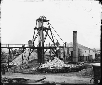
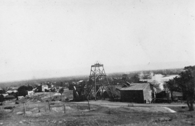
Photograph, Great Northern Cross Reef Gold Mining Company Stawell. Holtermann Photo 1874
Holterman 1874 Photo. Mine commenced 1858. First Mine in Stawell to have a steam driven poppet head. Holtermanns wagon for developing wet plate photographs is partly visible on lower right.Holtermann Black and White photograph of Stawell Mine April 1874. Tramway on left Winch house on right with square chimney. Poppet Head at centre of photo. Two Mullock heaps visible with some men on it as well as men on mine beamsmining -
 Stawell Historical Society Inc
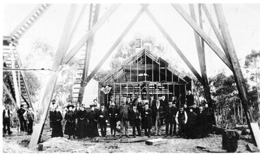
Photograph, Kinsella Family Lubeck, Cahill Mine Stawell c1896, 1896
... grampians Cahill Reward Gold Mine Company. Building still under ...Cahill Reward Gold Mine Company. Building still under construction c 1896 closed 1901. Thomas Kinsella had photo. In 1907 the Pleasant Creek Alluvial Mining Company reused the shaft digging down to 200 feet to work the ground and sank a second shaft nearby.Group of people standing under Poppet Head in front of partially constructed Engine House -
 Stawell Historical Society Inc
Book, West Scotchmans & Ulster Mines, 1940's - 1950's
Newspaper Reports from Pleasant Creek News 1868 - 1885gold mining -
Stawell Historical Society Inc
Book, Wonga Mines - Newspaper Reports, 1940's - 1960's
Includes Anglsea CD, great extended 1868 - 1899 Birrmingham Co., Wonga Wonga Co. Wonga Co., North Wonga Co. Typed Copies of Newspaper entriesBookgold mining -
Stawell Historical Society Inc
Book, West Scotchmans & Ulster Mines, 2019
Newspaper Reports from Pleasant Creek News - 1868-1885gold mining -
Stawell Historical Society Inc
Book, G.G. Gibson, 1916
The Magdala - Cum - Moonlight - Stawell & The Great Bolder Propietary Gold Mines Limited. Dimond Drilling 1914 - 1916gold mining -
 Stawell Historical Society Inc
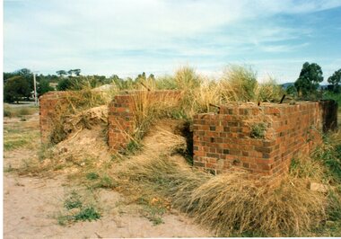
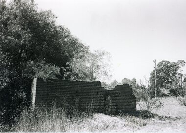
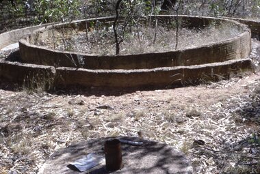
Photograph, Moonlight Extended remains
1 Colour, 1 B/W Photograph: Remnants of brick machinery foundations of Moonlight extended Mine. Located in Wood Street Looking Eastmining, moonlight extended mine, gold mining -
 Stawell Historical Society Inc
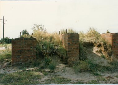
Photograph, Foundations from the Moonlight Extended Mine
2 Photographs, 1 Colour, 1 B/W. Brick foundations from the Moonlight Extended Mine in Moonlight Street Looking southgold mining, moonlight extended mine -
 Stawell Historical Society Inc
Photograph, Oriental Battery
... grampians Gold Mining Oriental Mine Mining 1 B/W Photograph ...1 B/W Photograph of the remains of brickwork with peppercorn trees in backgroundgold mining, oriental mine, mining -
 Stawell Historical Society Inc
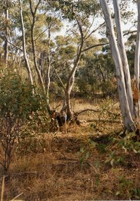
Photograph, Photograph showing bushland opposite the mines current entrance
Colour Photograph showing bushland opposite the mines current entrance, there were signs of trolly rails in 2000mining, gold mining -
 Stawell Historical Society Inc
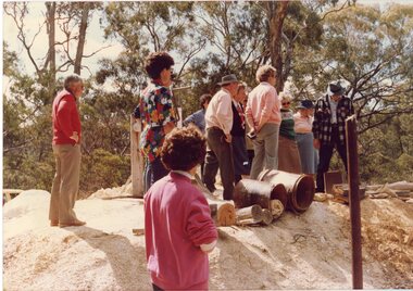
Photograph, Joe Mitchell's Mine
Stawell Historical Society Members visit Joe Mitchell's mine in the Ironbark, forest near Deep Lead. L to R Ian Jackson, Carmel Loats, Thelona Bullock, Allan Kingston, Betty Jackson, Betty Collins, Dorothy King, Leslie Bennett, Lawrie Bennett.Colour Photograph of a Group of people standing, looking down a mine shaft in bushland.mining, gold mininging, stawell historical society, deep lead -
Stawell Historical Society Inc
Map, Department of Mines Victoria, The Reefs. The Principle Reefs at Quartz Reefs, 1868
c1868 Map showing the position of principal Reefs at Quartz ReefsTracing Shewing the position of the principle reefs at Quartz Reefs. Scale 8 Chains to an inch mining, gold, map -
Stawell Historical Society Inc
Map, Department of Mines Victoria, Alluvial Map Stawell Region, 1870's
c1870 Coloured map showing Black Range North to Stawell and Illawarra. Shows geological layout.Department Mines Victoria 1952/G/2 mining, gold, map -
Stawell Historical Society Inc
Map, Stawell Gold Mine, Provisional Plan Wonga Area, c1980
... Stawell Gold Mine... Map Stawell Gold Mine ...c1980 Preliminary Provisional Reconnaissance Plan Showing Workings Above and Below water LevelWonga Area 1:1000 Base Geological Sheet mining, gold, map -
Stawell Historical Society Inc
Map, Geological Survey Office, Sloanes & Scotchmans united Mine, December 1916
Sloane & Scotchman's Geological Survey Map 1916 Showing Underground DrivesGeological Survey Office Ballarat December 1916 mining, gold, map -
Stawell Historical Society Inc
Map, Charles C Reilly, Oriental & North Cross Reef Mine showing underground drives, 3/5/1900
Underground Survey of Mines Stawell c1900Charles C Reilley 3.5.00 mining, gold, map -
Stawell Historical Society Inc
Map, Gold Mines of Australia, Gold Mines of Australia underground workings. Newington Rd Darlington Rd Area 1950, 1950
... Gold Mines of Australia Stawell Investment 2003 ... grampians mining gold map Gold Mines of Australia Stawell Investment ...Plans Showing Surveys & Drilling Stawell InvestmentGold Mines of Australia Stawell Investment 2003 mining, gold, map -
Stawell Historical Society Inc
Map, Gold Mines of Australia, Geological Plan Wonga Mine Area Stawell Investigation, 1950
... grampians mining gold map Gold Mines of Australia Ltd Plans Showing ...Plans Showing Stawell Investment 1950Gold Mines of Australia Ltd mining, gold, map -
Stawell Historical Society Inc
Map, Gold Mines of Australia, Stawell Investment Geological Plan. Mine Area showing Mineshafts
The Reefs Mine shaft locationsGold Mines of Australia Ltd mining, gold, map -
Stawell Historical Society Inc
Map, Western Mining Corp / Stawell Joint Venture, Stawell & District with Mine Working Areas shown in red, 1987
Covers from Magdala East site to Germania in North and Hand in Hand at West Legend of Mine workings numbered. 1980's mining, gold, map -
Stawell Historical Society Inc
Map, Stawell Gold Mine, SGM Mineralized System Longitudinal Projection showing Diamond Drilling Holes 2007, June 2007
... Stawell Gold Mine... Holes 2007 Map Stawell Gold Mine ...Section of Big Hill showing Diamond Drill holes through Magdala, Magdala North and Golden Gift Ore bodies to 2000m levelLegend of Mine workings numbered. 1980's mining, gold, map -
Stawell Historical Society Inc
Map, Stawell Gold Mine, Stawell Gold Mine Photo Map of Stawell Township showing Underground Declines in mining lease, 2007
... Stawell Gold Mine Photo Map of Stawell Township showing...Stawell Gold Mine.... Stawell Gold Mine Photo Map of Stawell Township showing ...SGM photo Map 2007 Produced for Public Consultation over Big Hill Open Pit Proposal. Aerial Views Stawellmining, gold, map -
Stawell Historical Society Inc
Map, Gold Mines of Australia, Plan of Stawell Goldfield. Mining Leases, 1952
And Shaft Locations 1952 G G Birch Mining Surveyormining, gold, map -
Stawell Historical Society Inc
Map, Stawell Joint Venture, Mine Site Detail Plan, September 1989
1989mining, gold, map -
 Stawell Historical Society Inc
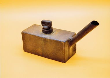
Photograph, Miners Lamp J Ladd
Used for a lamp in the gold minesRusted Rectangular Metal box with spout and screw top filling plugJ Laddmining, gold -
 Stawell Historical Society Inc
Photograph, Sloanes & Scotchmans Mine
Poppet Head and Engine House of Sloane & Scotchmans United Mine taken from Big Hill Facing North West. c 1915 to 1920mining, panorama, gold -
Stawell Historical Society Inc
Map, Stawell Gold Mine, Three dimensional View of Magdala Decline, March 1994
... Stawell Gold Mine... Decline Map Stawell Gold Mine ...View of Mine looking from Stawell Hospital towards Big Hill Levels indicate depth in metres below hillParallel View Scale 1 : 2600mining, gold -
Stawell Historical Society Inc
Map, Stawell Gold Mine, Perspective View Magdala Decline August 1989, August 1989
... Stawell Gold Mine... August 1989 Map Stawell Gold Mine D Bosher ...Shows Mining Levels Drawn By D. Bosher Stawell Joint Venture Victoria SJVmining, gold -
Stawell Historical Society Inc
Memorabilia - Badge, 1935
Home to Stawell 1935 Badge with Blue White Enamel showing Gold Minestawell -
 Stawell Historical Society Inc
Photograph, Stawell Gold Mine
... Stawell Gold Mine... grampians Gold Mining Chilean Mill Julbilee Area 1973 Stawell Gold ...Chilean Mill Julbilee Area 1973gold mining