Showing 1548 items matching "streetscape"
-
 Robin Boyd Foundation
Slide, Robin Boyd
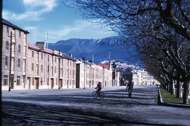
Colour slide in a mount. Streetscape, Salamanca Place, HobartMade in Australia / 63 (Handwritten) / Encircled 61 (Handwritten)hobart, slide -
 Robin Boyd Foundation
Slide, Robin Boyd, 1964
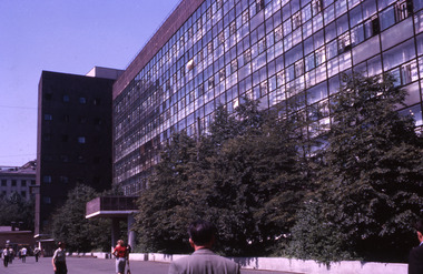
In 1964, Robin and Patricia Boyd spent several weeks on a world tour - Boyd took a leading role at the International Design Conference in Aspen and he also visited Chicago, Yale University, and New York’s World Fair. The Boyds then travelled on to England, Finland (especially to see Tapiola), Russia and India to see Le Corbusier's Chandigarh, and also Hong Kong and Thailand.Colour slide in a mount. Building and streetscape, unknown locationMade in Australia / 13 / AUG 64M / Encircled 2 (Handwritten) / 3 (Handwritten)slide, robin boyd -
 Sunbury Family History and Heritage Society Inc.
Photograph, 25th August 1995
This view of Sunbury Railway Station was taken from the corner of Brook and Evans Streets two years after the station underwent refurbishment and extensions and a carpark was constructed adjacent to the station. The Sunbury & District Heritage Association Inc. has a photograph P0663 of the station taken a century ago from the same place, when Sunbury was a small country town. The contrast between the two images is interesting. A coloured photograph of a streetscape with a weatherboard building in the middle distance,sunbury railway station, brook street -
 Bendigo Historical Society Inc.
Photograph - PALL MALL 1861, 1861
black and white photograph - copy of original: streetscape of Pall Mall showing Bank of Australasia at left ( on corner of Williamson St. with Batchelder's photographer handcart in front. From left to right Bank of Australasia, 'Rowkirk & Co. ' on curved parapet. Shows Pall Mall from corner of William St. at left towards Mitchell St. off the RH side of image.Batchelder, Sandhurstplace, streetscape, pall mall -
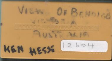 Bendigo Historical Society Inc.
Slide - KEN HESSE COLLECTION: PHOTOGRAPHIC SLIDES OF BENDIGO
A box of 28 photographic slides containing various views of Bendigo. Included are buildings and streetscapes. Item part of Mr. Ken Hesse Collection donated by Mr. James Lerk.slide, bendigo, buildings, ken hesse collection, collection, photographs, bendigo, buildings, history, place, streetscape -
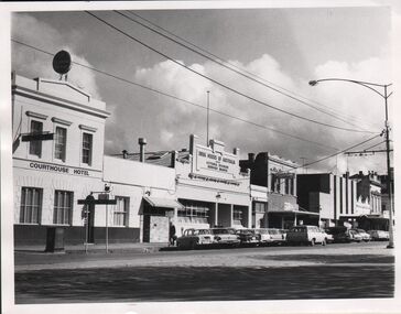 Bendigo Historical Society Inc.
Photograph - PALL MALL BENDIGO 1960SS
Black and white photographs (2 copies of same) . Image shows streetscape Pall Mall. From LH side of image Courthouse Hotel, Drug Houses of Australia Victoria Division,Bendigo Branch. Camelot restaurant, Bendigo Advertiser offices on RH side. Cars parked on kerb., lamp post and wires down middle of road. Sign on roadside 'Heathcote' with arrow pointing.bendigo, streetscape, pall mall -
 Canterbury History Group
Photograph - Streetscape of the shops on the eastern side of Theatre Place, Jan Pigot, 27/03/1993 12:00:00 AM
Coloured photograph of the streetscape of the shops on the eastern side of Theatre Placecanterbury, maling road, shops, theatre place -
 Bendigo Historical Society Inc.
Photograph - NATIONAL TRUST ENTRY
DVD. National Trust Entry Historic Towns, Bendigo Streetscapes. -
 City of Kingston
Photograph - Black and white
This photograph depicts the road diversion on Nepean Highway that was implemented to allow construction of the railway line underneath the Nepean Highway at Moorabbin. An "Allourie" Cheese, Honey Canned Ham van is prominent on the left of the image, the railway gates are central and the old Moorabbin Station is visble. Beyond the dates, pedestrians are visible crossing the Nepean Highway. This image is part of a larger collection of images from the Public Transport Corporation displaying train stations and streetscapes in what is now the City of Kingston.In 1958 excavations began for the removal of the level crossing gates at the southern end of the Moorabbin shopping centre on Nepean Highway. The station was also lowered below ground. A diversion route was created to enable the flow of traffic in both directions along the highway.Black and white photograph of road diversion on Nepean Highway, Moorabbin to allow the construction of the railway line below the Nepean Highway at Moorabbin and also to trench the station. This image is part of a larger collection of images from the Public Transport Corporation displaying train stations and streetscapes in what is now the City of Kingston.White adhesive dot sticker: Printed black 199 Handwritten in red ink: 80% Handwritten in black ink on yellow Post-It Note: [indecipherable] 199 - Diversion for Crossing Stamped in blue ink: COPYRIGHT Public Transport Corporation, For reordering photographs, Please quote negative No m 5687, Enquiries C/- PTC Photographic Unit, Telephone switchboard 619 1111railway crossing, railway station, city of moorabbin -
 Bendigo Historical Society Inc.
Photograph - CHARING CROSS/FOREST STREET: BENDIGO, 1860's
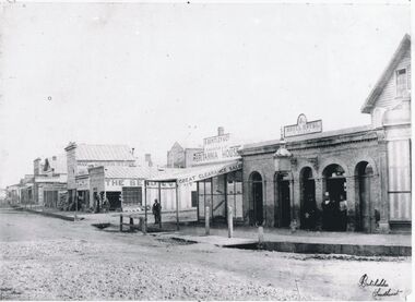
Black and white photo: copy. Streetscape at Charing Cross - side street is Forest Street, roadway to left of Forest St. is High St. Roadway to right of Forest Street is View Place. . On back 'Batchelder, Sandhurst, lower RH of image, in grey lead top RH on back No. 7 ' Busineses include J.B.Loridan steam chaff mills Hay & Corn Store The Benndigo Tin Shop Forest Street R.Bentley & Co Britannia House Royal Hotel Batchelder PhotoBatchelder Sandhurstplace, streetscape -
 Tatura Irrigation & Wartime Camps Museum
Photograph, Hogan Street
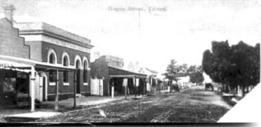
Streetscape of Hogan Street; featuring horse-drawn buggies; Bank of Victoriatatura, buildings, historic, transport, horse -
Canterbury History Group
Photograph - Streetscape showing shops No. 123 and 125 Maling Road, Jan Pigot, 27/03/1993 12:00:00 AM
Coloured photograph of the streetscape showing shops No. 123 and 125 Maling Roadcanterbury, maling road, shops, streetscapes -
Canterbury History Group
Photograph - Streetscape of the corner of the Maling Road Theatre at Theatre Place, Jan Pigot, 27/03/1993 12:00:00 AM
Coloured photograph of the streetscape of the corner of the Maling Road Theatre at Theatre Placecanterbury, maling road, shops, streetscapes, theatre place -
Canterbury History Group
Photograph - Streetscape of the shops between No. 103 to 109 Maling Road, Jan Pigot, 27/03/1993 12:00:00 AM
Coloured photograph of the streetscape of shops between No. 103 to 109 Maling Roadcanterbury, maling road, shops, streetscapes -
 Federation University Historical Collection
Postcards - black and white, Butt Bourton, Burford
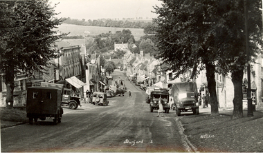
Burford is a small town on the River Windrush in the Cotswold hills in west Oxfordshire, England, about 18 miles (29 km) west of Oxford, 22 miles (35 km) southeast of Cheltenham and only about 2 miles (3 km) from the Gloucestershire boundary. The toponym derives from the Old English words burh meaning fortified town or hilltown and ford, the crossing of a river. (Wikipedia)A streetscape photographic view of Burford, England showing buildings, cars and people. chatham family archive, burford -
Whitehorse Historical Society Inc.
Document, 520 Mitcham Road, 2005
Papers relating to objections to development of 520-528 Mitcham Road Mitcham.Papers relating to objections to development of 520-528 Mitcham Road Mitcham. Includes: statement by Neil Edwin Kerby & Margaret Anne Kerby; Title searches for 449 Mitcham Road Mitcham and adjacent properties; plan of 1906 subdivision; ASIC extract of development company organisational details; aerial photos of the area; photographs of nearby properties and of Mitcham Road streetscapes and list of Mitcham objectors. CD copy at NP3771Papers relating to objections to development of 520-528 Mitcham Road Mitcham. mitcham road mitcham, nos. 520-528, kerby, neil edwin, kerby, margaret anne, mitcham road mitcham no. 449, 520 mitcham road pty ltd, listermay nominees pty ltd, land subdivision -
 Bendigo Historical Society Inc.
Booklet - Bendigo and the Golden North
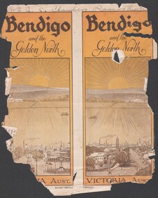
BHS Collection8537 Booklet presenting the public buildings, churches, recreation facilities, industry and parks and streetscapes of Bendigo in the early 1900s. Booklet is presented in B&W with numerous photographs of buildings and streetscapes of the city off Bendigo.golden north, tourist guide, notable buildings -
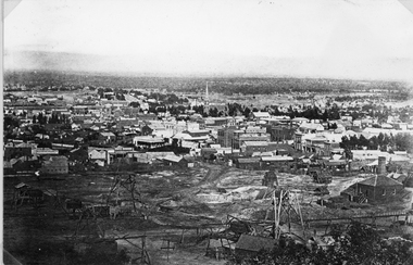 Stawell Historical Society Inc
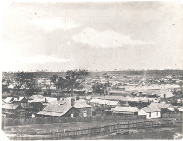
Photograph, Panorama of Stawell from Big Hill with Whims & Poppet Heads Victorian Views Collection C Herbert c.1880s
Views from Big Hill Sloane Street Fisher Street areas looking towards West. Mining in foreground of photo. Upper Main Street and Patrick Street Streetscapes visible. Mathers and Franklin. Agnew Draper. J R Franklin? Draper. Coffee Palace formerly Castlemaine Hotel , Town Hall visiblePanorama of Stawell from Big Hill showing Sloane's St. / Fisher St. areas. The photo has Whims & Poppet Heads in the foreground. There are around 6 copes of the photograph. Victorian Views. C. Herbert. Photo. Copyright Registered. Stawellstawell, panorama, mining, streetscape -
 Bendigo Historical Society Inc.
Photograph - EARLY PHOTOGRAPH BENDIGO PALL MALL CIRCA 1900, Circa 1900
Black & White Copy of Photograph Bendigo Streetscape Pall Mall Circa 1900.bendigo, history, pall mall streetscape circa 1900 -
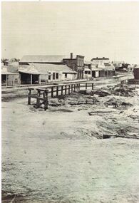
 Tarnagulla History Archive
Photograph of buildings on Commercial Road, Tarnagulla, Buildings on Commercial Road, Tarnagulla, Late 1960s
Murray Comrie Collection. Burstall Hall is visible in the distant background.Monochrome photograph, streetscape. Commercial Road Tarnagulla between Poverty and Wayman Streets. tarnagulla, buildings, commercial road -
 Tarnagulla History Archive
Photograph of buildings on Commercial Road, Tarnagulla, Buildings on Commercial Road, Tarnagulla, Late 1960s
Murray Comrie Collection. A good quality original print.Monochrome photograph, streetscape. Commercial Road Tarnagulla between Poverty and King Streets. tarnagulla, buildings, commercial road -
 Stawell Historical Society Inc
Photograph, Upper Main Street with the London Chartered Bank on the right, Mr W Muir Produce Dealer & the Bank of Victoria 1866
Main Street. On Right is London Chartered Bank. W Muir Produce Dealer. Bank of Victoria. Part of a collection of Photographs by Mr. O.G. Armstrong as commissioned by the Shire of Stawell for the Inter-colonial and Paris Exhibition in Melbourne in 1866. Another view of the top or eastern end of Main Street 1866. It is almost the same area as in photo No 14 but looking westward towards the Grampians. Streetscape with bend of road in foreground. Bank of Victoria prominent on right side of image.stawell businesses streetscape -
Canterbury History Group
Photograph - Streetscape of shops on the south side of Maling Road, Jan Pigot, 27/03/1993 12:00:00 AM
Coloured photograph of the streetscape of several shop fronts on the south side of Maling Road.canterbury, maling road, shops, signs, wunderlite ceiling -
 Bendigo Historical Society Inc.
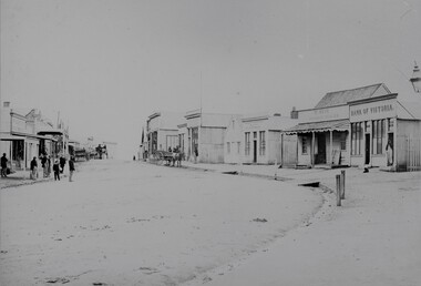
Photograph - PALL MALL SANDHURST , 1857, 1857
Sepia photograph of early Bendigo streetscape, Stone building in in forefront LH side, now View Street. In Pall Mall on left is the Shamrock Hotel, then the building that now houses the Bendigo Bank, in the centre is 23 the sign below possibly reads ELVTA, to the right is Edmonds Horse Bazaar, 2 doors to the right is the 2 story building that housed the Colonial Bank, beside that is Victoria Hotel then the stables which became Allan's walk. Markings/Inscriptions: none.place, streetscape, pall mall -
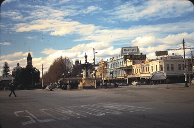
 Bendigo Historical Society Inc.
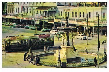
Postcard - CHARING CROSS/ALEXANDRA FOUNTAIN, BENDIGO
Postcard, coloured, streetscape view of Charing Cross and Pall Mall. Alexandra Fountain in foreground, tram behind heading towards View Street. Cars parallel parked along street in Pall Mall. The Beehive, Ezywalkin, stores in image.bendigo, streetscape, charing cross, bendigo, alexandra fountain, tram, ezywalkin, beehive, tram, charing cross -
 Bendigo Historical Society Inc.
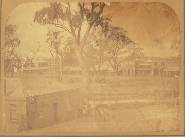
Photograph - HARRY BIGGS COLLECTION: BENDIGO LANDSCAPE VIEW OF COTTAGES, c1850's (late) Pre 1864
Photograph. Harry Biggs Collection. 2 Black and white streetscape of Bendigo City from Forest Street late 1850's. The long Beehive Store can be seen. In the foreground are many cottages long since gone. A stand of trees along the ridge can be seen. Black & white photos, Forest St in foreground - dirt road picket fence.photograph, streetscape, bendigo, harry biggs collection, bendigo streetscape -
Canterbury History Group
Photograph - Streetscape outside shop No. 84 and No. 82 Maling Road, Jan Pigot, 27/03/1993 12:00:00 AM
Coloured photograph of the streetscape outside 2 shops in Maling Road depicting street plantingcanterbury, maling road, shops, streetscapes, street tree plantings -
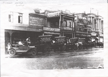
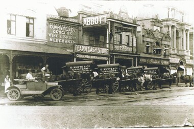 Bendigo Historical Society Inc.
Photograph - PALL MALL EARLY 1900'S, 1900
Four Black and white photos in 2 different sizes, streetscape with horse and buggies - D Whyte & Co Grocers written on side, One car with open top and male driver, also included is a photocopied sheet with information on D Whyte and Co.photograph, streetscape, d whyte, d whyte and co, d whyte & co, pall mall, horse and buggies, horse & buggies, abbot, white, sutton -
 Bendigo Historical Society Inc.
Photograph - LONG GULLY HISTORY GROUP COLLECTION: STREETSCAPE
Black and white photograph of streetscape, various buildings on right hand side and a wooden fence on the rightbendigo, history, long gully history group, the long gully history group - streetscape, dr j w sibley, commercial hotel -
 Bendigo Historical Society Inc.
Slide - CASTLEMAINE HISTORICAL SOCIETY COLLECTION, ALEXANDRA FOUNTAIN, 1955
Slide. Alexandra Fountain, Charing Cross, Bendigo. Pall Mall streetscape in background. Dated 28.5.55slide, bendigo, alexandra fountain, castlemaine historical society collection alexandra fountain charring cross bendigo