Showing 434 items matching "suburban street"
-
 Eltham District Historical Society Inc
Photograph - Colour Print, Belle Vue, Livingstone Road, Eltham, c.2015
Belle Vue property in Livingstone Road, Eltham was once owned by Society member Jo McCormick. Jo was a valued member of our committee and dear friend of many of our members until her death in 2009. Belle Vue is the farmhouse of a property that is now a significant part of suburban Eltham, just a short distance north of the town centre. Originally purchased by pioneer Eltham farmer Henry Stooke, the present-day old farmhouse sits within an extensive suburban residential area. The history of the property is largely based on a heritage assessment prepared by consultant Lorraine Huddle for Nillumbik Shire Council. Additional information from our Society records reveals Belle Vue farm comprised about 56 ha (140 acres) extending northerly from the northern boundary of Holloway’s 1851 Little Eltham subdivision. On the present day map the southern boundary was just north of Elsa Court and Grove Street. The western boundary was the Diamond Creek and extended northerly to Main Road where it turns easterly towards Research. It was traversed by the main road to Kangaroo Ground and beyond and from 1912 by the railway to Hurstbridge. From 1895 the farm was owned by William Williams and his wife Mary Ann. In 1914 -15 they built a new house now known as Belle Vue. They sold the land in 1920 and residential subdivision began soon after that. Belle Vue remains today on a substantially subdivided and very much reduced size residential lot in Livingstone Road. The house and many old trees on the site were subject to a heritage overlay under the Nillumbik Planning Scheme. Despite that overlay, the development and subdivision of the original land resulted in most of the heritage listed trees being removed. belle vue, eltham, livingstone road -
 Glen Eira Historical Society
Document - Capek, Irene Mrs
Four items Typed notes by Irene Capek, dated May 1993, describing her arrival in Melbourne 08/04/1949 and subsequent life in Caulfield, with accompanying letter dated 09/05/1993 from her to the Campbells. Cop of Irene Capek’s notes published in Caulfield Historical Society’s Newsletters No.38 October 1993 and No.39 April 1994. Typed notes by Irene Capek dated May 1994, describing her life at Norwood Road, including her community activities and her son’s experience at school, with accompanying letter dated 26/05/1994. Undated research notes by unknown person, from 1948 Sands and McDougall re ‘Matlock’ and Lawrence Pendlebury.capek irene, capek john, capek fred, maclaren dr., sanger rabbi dr., winkler mrs., winkler mr., winkler louis, davies david, davies valerie, davies lindy, dennis c.j., pendlebury lawrence, pendlebury ann, gude nornie, capek ann, caulfield north primary school, fred capek and associates consulting engineers, caulfield historical society, campbell mr., campbell mrs., migrants, migrant services, immigration, councillors, engineers, efca engineering pty ltd, suburban life, domestic life, caulfield, caulfield north, norwood road, alma road, dandenong road, church of christ caulfield north, caulfield park, matlock, glenhuntly road, albion street, caulfield south, jackson miss, hawthorn road, variety service agency, caulfield town hall, hanbury rosemary, greenall mrs., teachers, capek john, capek ann, charities, community services, employment, fundraising events, thai community, citizenship ceremonies, voluntary workers, boarding houses, rationing, private garages, synagogues, builders, manufacturing industry, ex-service organisations, marble, fireplaces, refugees, discrimination -
Glen Eira Historical Society
Article - PRENTICE STREET, 47, ELSTERNWICK
Three sets of real estate campaigns for this property: 1/Property Review Weekly newspaper article date 13/12/2002 includes one coloured photograph. The article gives details of renovations done ten years previously and modern features for efficient energy. Also notes suburban locality features. 2/Newspaper article 03/02/2003 gives brief detail on home features both this and above include similar coloured photograph. 3/Newspaper article dated March 2009 gives detail on home features and garden amenities. 4/Real estage agent A4 flyer plus small newspaper ad (Domain 19/04/2013) for auction of 11/05/2013. Included are 2 colour exterior (front and rear) plus 2 colour interior photos for this Edwardian home.prentice street, elsternwick, peer gary, estate agents, timber houses, stefanis angelos, stavrakis bill, kelly juanita, bigginscott, edwardian style -
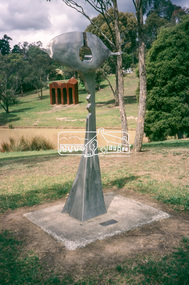 Eltham District Historical Society Inc
Slide - Photograph, Sculpture, Surveyor of Suburban Environs, Ernst Fries (1991), Alistair Knox Park, cnr Bridge Street and Main Road, Eltham, c.1993
35mm colour positive transparency Mount - Black and Whitealistair knox park, art in public places, classical-landscape (1996), cliff burtt, public art, sculptures, surveyor of suburban environs (1991) -
 Flagstaff Hill Maritime Museum and Village
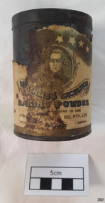
Container - Tin, McKenzies Foods, circa 1930s
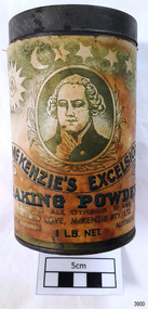
This tin once contained McKenzie’s baking powder, a cooking ingredient. It was donated with other similar tins that were used by the donor’s mother who was married in 1932. It those times in Australia all manner of household items, including food and drink, were sold by hawkers (salesmen) who travelled from door to door in both suburban and rural areas. The donor remembered the bicarb soda tin on her mother’s pantry shelf. The McKenzie’s Baking Powder label adds the information that the ingredients were “Prepared with Aerophos, Regd. Trade Mark, the finest raising ingredient. A product of Albright & Wilson, Australia Pty. Ltd.” It also says that it “Excels all others in use”. The Australian family business, McKenzie’s Foods, began in Melbourne in 1852 and continues today, now run be the fifth generation of descendants from the original owners. Its baking and cookery products are well recognised by Australians. This tin originates in the early 1900s from an Australian company that is now managed by fifth generation descendants of the original family after its inception in 1852. The tin increases in significance for its use as a recognised object found in many Australian kitchens since early days. It gives a snapshot into domestic life and social norms of the pre and post war period in Melbourne The tin is significant for its association with a local family in the 1930s for the preparation of family meals. Tin container, cylindrical, with cream paper label with gold highlights, motif and text. Used for selling McKenzie’s Excelsior baking powder. Container has push-on lid. Quantity of 1/2 LB. NETT. Made in Australia by Jas. F. McKenzie & Co. Pty Ltd. Text includes “JAS. F. McKENZIE & CO. PTY. LTD. / AUSTRALIA“ “McKENZIE’S EXCELSIOR / BAKING POWDER”. Motif: man’s portrait within oval frame with wheat sheaf border, placed below figures of sun, moon and stars. Information and instructions. flagstaff hill asset, baking powder tin, container, flagstaff hill museum, kitchen item, cookery, baking, grocery, mckenzie, rising agent, food container, flagstaff hill, warrnambool, shipwrecked coast, flagstaff hill maritime museum, maritime museum, shipwreck coast, flagstaff hill maritime village, great ocean road, tin, cooking ingredient, baking powder, mckenqie -
 Flagstaff Hill Maritime Museum and Village
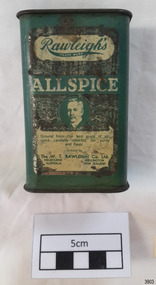
Container - Tin, W T Rawleigh, Circa 1930s
This tin once contained Rawleigh's Allspice, a cooking ingredient. It was donated with other similar tins that were used by the donor’s mother who was married in 1932. It those times in Australia all manner of household items, including food and drink, were sold by hawkers (salesmen) who travelled from door to door in both suburban and rural areas. The donor remembered the tin on her mother’s pantry shelf. The Rawleigh Nutmegs label stated “Selected whole nutmegs not ground but granulated to preserve full strength and flavour.” The company had operated in Melbourne, Australia, and Wellington, New Zealand. W.T. Rawleigh & Co. was established by William Rawleigh in America in 1889 and later expanded into Australia. The company made a variety of household products in a factory in Collins Place, Melbourne, between 1930 and 1935. It specialised in medicines and remedies, food additives, cleaning products and toiletries. The company in Melbourne expanded into their factory in Dawson Street, Brunswick, in the mid-1930s. Independent salesmen, often referred to as ‘The Rawleigh’s man’, sold Rawleigh products door-to-door between the wars and after the Second World War in the Melbourne suburbs. Rayleigh’s products are still produced today. The tin is significant for its association with W.T Rawleigh, one of Melbourne’s strong growing manufacturers in period particularly between the World Wars. Rawleigh’s was, and still is, well known for its household and cleaning products, medicines, food additives and toiletries. The tin increases in significance for its use as a recognised object found in many Australian kitchens since early days. It gives a snapshot into domestic life and social norms of the pre and post war period in Melbourne The tin is significant for its association with a local family in the 1930s for the preparation of family meals. Rawleigh's rectangular Allspice spice tin, green, with directions for use on back and sides of container.Text “Rawleigh’s ALLSPICE” “The W.T. RAWLEIGH Co. Ltd.” “MELGOURNE / AUSTRALIA” “WELLINGTON / NEW ZEALAND” Motif: Man’s portrait in a circle. Other text includes information about spices.flagstaff hill museum, container, spice container, rawleigh company, tin container, kitchen item, tin, cooking ingredient, food container, grocery, allspice, rawleigh co. -
 Flagstaff Hill Maritime Museum and Village
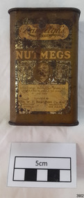
Container - Tin, W T Rawleigh, Circa 1930s
This tin once contained Rayleigh's Nutmegs, a cooking ingredient. It was donated with other similar tins that were used by the donor’s mother who was married in 1932. It those times in Australia all manner of household items, including food and drink, were sold by hawkers (salesmen) who travelled from door to door in both suburban and rural areas. The donor remembered the tin on her mother’s pantry shelf. The Rawleigh Nutmegs label stated “Selected whole nutmegs not ground but granulated to preserve full strength and flavour.” The company had operated in Melbourne, Australia, and Wellington, New Zealand. W.T. Rawleigh & Co. was established by William Rawleigh in America in 1889 and later expanded into Australia. The company made a variety of household products in a factory in Collins Place, Melbourne, between 1930 and 1935. It specialised in medicines and remedies, food additives, cleaning products and toiletries. The company in Melbourne expanded into their factory in Dawson Street, Brunswick, in the mid-1930s. Independent salesmen, often referred to as ‘The Rawleigh’s man’, sold Rawleigh products door-to-door between the wars and after the Second World War in the Melbourne suburbs. Rayleigh’s products are still produced today. The tin is significant for its association with W.T Rawleigh, one of Melbourne’s strong growing manufacturers in period particularly between the World Wars. Rawleigh’s was, and still is, well known for its household and cleaning products, medicines, food additives and toiletries. The tin increases in significance for its use as a recognised object found in many Australian kitchens since early days. It gives a snapshot into domestic life and social norms of the pre and post war period in Melbourne The tin is significant for its association with a local family in the 1930s for the preparation of family meals. Rawleigh spice tin, rectangular, tall, used for storing Rawleigh's nutmeg. Tin has a flip-top lid, is coloured gold and comes with directions for use on front, back and sides of container.Text includes “W.T. RAWLEIGH Co. Ltd.”, “MELBOURNE / AUSTRALIA”, WELLINGTON / NEW ZEALAND” “Rawleigh’s / NUTMEGS” Motif: man’s portrait in a circle. Other text includes information about spices.tin container, flagstaff hill, warrnambool, shipwrecked coast, flagstaff hill maritime museum, maritime museum, shipwreck coast, flagstaff hill maritime village, great ocean road, food container, tin, kitchen item, container, cooking ingredient, grocery, spice container, nutmeg, rawleigh co. -
 Flagstaff Hill Maritime Museum and Village
Container - Tin, McKenzies Foods, circa 1930s
This tin once contained McKenzie’s baking powder, a cooking ingredient. It was donated with other similar tins that were used by the donor’s mother who was married in 1932. It those times in Australia all manner of household items, including food and drink, were sold by hawkers (salesmen) who travelled from door to door in both suburban and rural areas. The donor remembered the bicarb soda tin on her mother’s pantry shelf. The McKenzie’s Baking Powder label adds the information that the ingredients were “Prepared with Aerophos, Regd. Trade Mark, the finest raising ingredient. A product of Albright & Wilson, Australia Pty. Ltd.” It also says that it “Excels all others in use”. The company began in Melbourne in 1852 and continues today, now run be the fifth generation of descendants from the original owners. This tin originates in the early 1900s from an Australian company that is now managed by fifth generation descendants of the original family after its inception in 1852. The tin increases in significance for its use as a recognised object found in many Australian kitchens since early days. It gives a snapshot into domestic life and social norms of the pre and post war period in Melbourne The tin is significant for its association with a local family in the 1930s for the preparation of family meals. Tin container, cylindrical, with cream and green paper label with gold highlights, motif and text. Used for selling McKenzie’s Excelsior baking powder. Container has push-on lid. Quantity of 1LB. NET. Made in Australia by McKenzie Ltd.Text includes “CLIFFORD LOVE, McKENZIE PTY. LTD.” “McKENZIE’S EXCELSIOR / BAKING POWDER”. Motif: man’s portrait within oval frame with wheat sheaf border, placed below figures of sun, moon and stars. Information and instructions. flagstaff hill asset, baking powder tin, container, flagstaff hill museum, kitchen item, cooking ingredients, flagstaff hill, warrnambool, shipwrecked coast, flagstaff hill maritime museum, maritime museum, shipwreck coast, flagstaff hill maritime village, great ocean road, tin, cooking ingredient, food container, grocery, cookery, rising agent, baking powder, mckenzie, mckenzie foods -
![Newspaper Clipping - Digital Image, Street poll on streets 1974 [Greenhills], 24/09/1974](/media/collectors/4f729f5697f83e03086015b8/items/5eb52fca21ea671f18ffc9aa/item-media/5eb5300621ea671f18001764/item-fit-380x285.jpg) Greensborough Historical Society
Greensborough Historical SocietyNewspaper Clipping - Digital Image, Street poll on streets 1974 [Greenhills], 24/09/1974
Results of a poll conducted in 1974 by Diamond Valley Council, regarding street construction in Greenhills. Streets include: Albion Crescent, Bruce Street, Carnon Street, Cairns Street, Crest Street, Mine Street, Pembroke Street, Hope Street, Forrest Street and Hebden Street.Concerns over street construction as Greensborough moves from a semi rural to suburban area.News clipping, black and white text.shire of diamond valley, greenhills, street construction, albion crescent greensborough, carnon street greenhills -
 Greensborough Historical Society
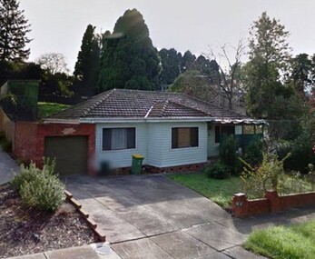
Photograph - Digital Image, 42 Alexandra Street Greensborough, 2000c
... Greensborough alexandra street greensborough weatherboards suburban ...House at 42 Alexandra Street GreensboroughDigital colour photographs alexandra street greensborough, weatherboards, suburban housing -
 Greensborough Historical Society
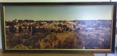
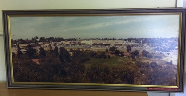
Photograph (Framed), Greensborough December 1977, 1977_12
Photograph two of a series of three panoramic photographs of Greensborough before and after the construction of Greensborough Plaza at the end of the 1970s. Shows the changing landscape of Greensborough from rural to suburban township.These photographs clearly show the change in the street scape of Greensborough from the Hailes Street/Circuit side of town.Panorama photograph in timber frame. One of three in series.Labelled in red on front of frame "Greensborough ... December 1977"greensborough, greensborough plaza -
 Greensborough Historical Society
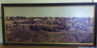
Photograph (Framed), Greensborough in June 1977, 1977_06
Photograph one of a series of three panoramic photographs of Greensborough before and after the construction of Greensborough Plaza at the end of the 1970s. Shows the changing landscape of Greensborough from rural to suburban township.These photographs clearly show the change in the street scape of Greensborough from the Hailes Street/Circuit side of town.Panorama photograph in timber frame. One of three in series. Labelled in red on front of frame 'Greensborough June 1977"greensborough, greensborough plaza -
 Greensborough Historical Society
Photograph (Framed), Greensborough in December 1978, 1978_12
Photograph three in a series of three panoramic photographs of Greensborough before and after the construction of Greensborough Plaza at the end of the 1970s. Shows the changing landscape of Greensborough from rural to suburban township.These photographs clearly show the change in the street scape of Greensborough from the Hailes Street/Circuit side of townPanorama photograph in timber frame. One of three in series. Labelled in red on front of frame 'Greensborough December 1978'greensborough, greensborough plaza -
 Greensborough Historical Society
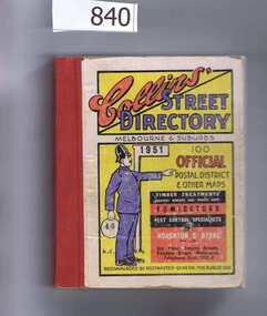
Book, Collins' Street Directory: Melbourne & suburbs 1951, 1951_
... . A comprehensive coverage of suburban, inner city streets. melbourne street ...This 1951 street directory covers many Melbourne suburbs but not Greensborough. In the 1950s Greensborough was still a rural settlement. This directory is interesting for anyone wanting to check mid-20th century developments.A comprehensive coverage of suburban, inner city streets.Street directory. 411 pages, maps.melbourne, street directories -
 Greensborough Historical Society
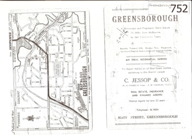
Map, Broadbent's, Greensborough, 1953_
This road map was a part of a Broadbent's Melbourne suburban directory from 1953.It shows the lay out of Greensborough's streets in 1953.It also shows some different street names to those used today. It also features a C Jessop & Co. Real estate advertisementA 1 page photocopy of a road map of Greensborough from 1953.Nilgreensborough, c jessop, broadbents, map no 242, road maps, 1953 -
 City of Moorabbin Historical Society (Operating the Box Cottage Museum)
Manufactured Glass, brown bottle 'Fauldings Aspirin', c1950
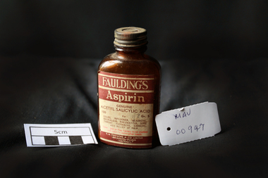
Francis Hardy Faulding 1816 – 1868 arrived in Sydney 1842. He was a Surgeon on the emigrant ship Nabob. 1845 Francis Hardy Faulding opened his first pharmacy at 5 Rundle Street in Adelaide and the business prospered. In 1867 he formed F.H Faulding & Co with Luther Scammel. as wholesale druggists and manufacturing chemists. Two of the Faulding company's major innovations were the development of a process for distillation of eucalyptus oil, and the development of the test for determining the eucalyptol content of the oil. Faulding's success was founded on eucalyptus oil, which formed the basis of an antiseptic marketed as "Solyptol" In 1868 Francis Hardy Faulding died, aged 52 at his suburban Glen Osmond home in Adelaide. Scammel’s two sons took over the business in 1888 and in 1890 the Company expanded to West Australia, then Sydney, Brisbane and finally, in 1924, Faulding began operations in Exhibition Street, Melbourne, eventually adding wholesale activities. 1986 With a presence in every city, from Darwin to Tasmania. Faulding becomes a truly national company. 2008 Zuelllig Group takes control Focusing solely on pharmaceutical wholesaling and distribution, Hong Kong based Zuelllig Group takes over control of Symbion Pharmacy Services. 2008 Symbion Pharmacy Services exceeds $3 billion with one of the country's largest networks of warehousing systems and service A brown glass, bottle with a metal screw top containing ‘Faulding's Aspirin’ tabletsFront label : FAULDINGS / ASPIRIN / GENUINE / ACETYL SALICYLIC ACID / 100 Gr 5 / for / Colds, .............. / DOSE ........... / F.H.FAULDING & CO LTD / MANUFACTURING CHEMISTS / AUSTRALIApharmacy, medicines, faulding f.h., scammell luther, faulding's aspirin, glassware, bottles, moorabbin, bentleigh, cheltenham, antiseptics, analgesics, pharmaceuticals, south australia, ss nabob, f.h.faulding & co. -
 Eltham District Historical Society Inc
Photograph, Liz Pidgeon, Heritage Excursion; East of Eltham, 6 Sep 2014, 20 May 2017
Newsletter No. 218, September 2014 September Excursion - East of Eltham Walk In Newsletter No. 197, March 2011, there was a brief history of Crown Allotment 15 Section 5 Parish of Nillumbik (CA 15) a parcel of land of a quarter of a square mile extending from Eucalyptus Road to Reynolds Road at the eastern extremity of Eltham. From the 1940s it was known as Stokes orchard. In later years it has been subdivided for residential purposes but leaving significant areas as power line and water supply reserves and bushland reserves that are habitat for the threatened For our excursion on 6th September we intend to walk through CA 15 to a bushland reserve east of Reynolds Road. The walk will traverse the boundary between suburban Eltham and the non-urban areas to the south and east. This is a pleasant walk through residential areas and bushland. Along the way we will discuss the early and more recent history of CA 15 as well as local natural history and geology. This walk is about 3.5 km in length and will take 2 to 2.5 hours. It will start at 2pm at the corner of Eucalyptus Road, Pitt Street and Nyora Road.Born Digitaleltham east, eltham district historical society, heritage excursion, activities, nyora road, reynolds road, gum tree road reserve, diosma road, stokes orchard, eucalyptus road -
 Eltham District Historical Society Inc
Photograph, Liz Pidgeon, Heritage Excursion; East of Eltham, 6 Sep 2014, 20 May 2017
Newsletter No. 218, September 2014 September Excursion - East of Eltham Walk In Newsletter No. 197, March 2011, there was a brief history of Crown Allotment 15 Section 5 Parish of Nillumbik (CA 15) a parcel of land of a quarter of a square mile extending from Eucalyptus Road to Reynolds Road at the eastern extremity of Eltham. From the 1940s it was known as Stokes orchard. In later years it has been subdivided for residential purposes but leaving significant areas as power line and water supply reserves and bushland reserves that are habitat for the threatened For our excursion on 6th September we intend to walk through CA 15 to a bushland reserve east of Reynolds Road. The walk will traverse the boundary between suburban Eltham and the non-urban areas to the south and east. This is a pleasant walk through residential areas and bushland. Along the way we will discuss the early and more recent history of CA 15 as well as local natural history and geology. This walk is about 3.5 km in length and will take 2 to 2.5 hours. It will start at 2pm at the corner of Eucalyptus Road, Pitt Street and Nyora Road.Born Digitaleltham east, eltham district historical society, heritage excursion, activities, nyora road, reynolds road, gum tree road reserve, diosma road, stokes orchard, eucalyptus road