Showing 268 items
matching swamp.
-
 Glen Eira Historical Society
Article - LONG, JOHN
This file contains two items: 1/A photocopied carbon copy detailing Robert Marriott and John Long from their arrival in Victoria. It notes that both became councillors in the City of St. Kilda and where they lived. 2/Photocopied photo from ‘Sand, Swamp and Heath’ of Caulfield Borough Council, 1901. Includes John Long, page 24.marriott robert, long john, gold, caulfield, councillors, st. kilda, hawthorn road, alexander hospital, hospitals, flowers street, laura street, glenhuntly road, marriott john, bambra road, field street -
 Friends of Ballarat Botanical Gardens History Group
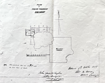
Work on paper - Site of the Ballarat Botanical Gardens, Plan of Police Paddock, Ballarat, 6th October 1855, October, 1855
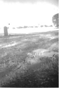
... swamp. ...Plan of Police Paddock, Ballarat, 6th October 1855.In 1855, the Police Paddock occupied the land of the present Ballarat Botanical Gardens.One large white sheet of paper photocopied and folded with a black margin at either end, and the plan and printing in longhand.The Plan is signed and dated by the Acting Surveyor and Assistant Surveyor, October, 1855.john garner collection, garner, dr, police, paddock, plan, map, 1855, ballarat botanical gardens, ballarat, gardens, wendouree, swamp. -
 Mortlake and District Historical Society
Queen Victoria's Oak Tree
This magnificent English oak tree is located at Tea Tree Lake park in Mortlake. This park was formerly the Botanic Gardens which were developed on what had been swamp land. An artificial lake was created there in 1988 as a Bi-Centenary project.The tree is located adjacent to the historic Montgomery Pavillion and was planted on the occasion of Her Majesty Queen Victoria's birthday on 24th May 1883. An outstanding tree, planted to commemorate a much-revered Queen in an historically-significant Botanic Gardens (now much altered). A very old oak tree planted 1883. queen victoria, mortlake, mortlake botanic gardens, tea tree lake, montgomery pavillion -
 Warrnambool and District Historical Society Inc.
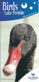
Document, Pamphlets lake Pertobe, 2014
Lake Pertobe in Warrnambool is a former swamp area which was transformed into a recreational area and children’s playground in the 1970s. The reserve is a popular spot for bird watching with over 80 species found in the vicinity. The brochure on Lake Pertobe’s birds had been produced by BirdLife Warrnambool, part of BirdLife Australia, an independent, not-for profit organisation aiming to protect our birdlife and disseminate information on Australian birds. This is an important little brochure as it contains information for locals and tourists about the birdlife in Lake Pertobe, one of the best-known and best-loved spots in WarrnamboolThis is an A3 sheet of paper printed on both sides and folded three times to form a brochure. It contains colour photographs of birds, two maps and information about BirdLife Warrnambool and BirdLife Australia and the logo of Birdlife Warrnambool.Front Cover: ‘Birds of Lake Pertobe, Warrnambool, BirdLife Warrnambool, Birds are in our nature’ lake pertobe, birdlife warrnambool, warrnambool -
Glen Eira Historical Society
Document - Goe, Field Flowers, Bishop
Three items about this Bishop of Melbourne and his connection to Caulfield: An article taken from Australian Dictionary of Biography v.9 1891-1939 on Field Flowers Goe (1832-1910). Field Flowers and Goe Street names off Bambra Road, South of Glenhuntly Road. Handwritten document researched by M. Dunbar 12/03/2013 taken from Sand, Swamp and Heath.goe field flowers, priest, caulfield historical society, field street, flowers street, goe street, bambra road, glenhuntly road, sand swamp and heath, goe emma, rodgers emma, anglican church -
Glen Eira Historical Society
Document - Bertram Street, 37, Elsternwick
A one page copy of correspondence dated 22/04/1988 concerning Bertram Street, 37, Elsternwick, the Gardenvale Railway Station and land sales in the area. Researched by the Brighton Historical Society. The file also includes a one page handwritten excerpt from the publication Sand, Swamp and Heath by Murray and Wells, about the subdivision named Gardenvale and the occupiers of Bertram Street, 37, Elsternwick.bertram street, elsternwick, prowse reginald, watson george j, gardenvale, parnell street, muntz street, muntz edwin parnell, muntz thomas b, surveyors, engineers, gardenvale station, market gardens, small and edwards, land developers, gardenvale on the hill, bullock h, landells rosalind -
Glen Eira Historical Society
Letter - Whittaker, G, Mrs
File contains 2 items: 1/ A handwritten letter by Mrs G. Whittaker on her personal memories/recollections of South Caulfield, which includes neighbours’ transport, homes, businesses and properties, some of which may have been included in ‘Sand, Swamp and Heath’ by Murray and Wells. 2/ Handwritten research note dated 27/09/2013 by Peta Darke concerning Mrs Whittaker’s parents’ house.whittaker g mrs, caulfield, flowers street, council employees, caulfield council, chinese community, market gardens, quong sing, bealiba road, trams, bambra road, glenhuntly road, glen huntly road, pearce’s nursery, nurseries, pearce mr, prisoners, pearce street, chloris street, benbow family, griffiths brothers teas, griffiths street, longs bull paddock, long mr, methodist church, hawthorn road, camden town methodist, mcconchie harry, mcconchie cricket ii, glenhuntly road, camden court, freeman street, lomax frederick, chloris park -
 The Beechworth Burke Museum
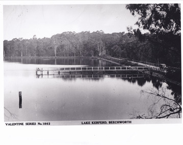
Postcard - Postcard - Reproduction, c.1930's - 1940's
This photograph is a copy of the Valentine series postcard originally produced c.1920. The photograph copy was recorded made c. 1930's - 40's, depicting Lake Kerferd, Beechworth. Lake Kerferd was built in 1862 to assist for gold mining activities as it held the waters of the Hurdle Swamp. The retaining wall built to create Lake Kerferd is depicted in the photograph adjacent to a narrow road, the make of the single automobile shown is consistent with the date recorded. The photograph is socially significant due to the connection of Beechworth in the past, present and future. Originally developed for gold mining activities which is a strong research area as the foundation of many towns in Australia's history. Black and white rectangular photograph printed on matte photographic paper.5461 Obverse: Valentine Series No.1862/LAKE KERFERD, BEECHWORTH 5461 Reverse: BMM2961/5461burke museum, lake kerferd, hurdle swamp, gold mining, beechworth, valentine series postcard, automobile, trees, jetty, reflection, car -
Glen Eira Historical Society
Document - ARMSTRONG, KATE MARY
1/Printed page from ‘The Argus’, 19/09/1941 from TROVE on Kate Mary Armstrong who is purported to be the first white child born in Caulfield. Mary was a daughter of a local family, father Thomas Watts who was also one of Melbourne’s first city architects. 2/Photocopied photo of Watts family taken from ‘Sand, swamp and heath . . .’, by P R Murray and John C Wells, page 82armstrong kate mary, watts mrs, pioneer, caulfield, watts thomas, architects, glenhuntly, brock n j mrs armstrong (stanley) s.e, armstrong j a mr, armstrong william george, armstrong james, watts t h rev, langley canon, st mary’s church glen eira road -
 The Beechworth Burke Museum
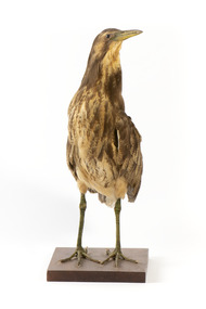
Animal specimen - Australaisn Bittern, Trustees of the Australian Museum, 1860-1880
The Australaisn Bittern is a partly nocturnal bird who resides in costal and sub-coastal locations in south-west mainland Australia, south east Australia and Tasmania. They can be found in wetlands, swamps and among reeds. These birds are mostly brown and yellow in colour and with short legs and a stocky body. The "woomph" sound made by the Bittern late at night is thought to have been the origin of the traditional Aboriginal myth of the Bunyip. The Bunyip, like the Australasian Bittern, was believed to reside in reedy swamps. This specimen is part of a collection of almost 200 animal specimens that were originally acquired as skins from various institutions across Australia, including the Australian Museum and the National Museum of Victoria, as well as individuals such amateur anthropologist Reynell Eveleigh Johns between 1860-1880. These skins were then mounted by members of the Burke Museum Committee and put-on display in the formal space of the Museum’s original exhibition hall where they continue to be on display. This display of taxidermy mounts initially served to instruct visitors to the Burke Museum of the natural world around them, today it serves as an insight into the collecting habits of the 19th century. This specimen is part of a significant and rare taxidermy mount collection in the Burke Museum. This collection is scientifically and culturally important for reminding us of how science continues to shape our understanding of the modern world. They demonstrate a capacity to hold evidence of how Australia’s fauna history existed in the past and are potentially important for future environmental research. This collection continues to be on display in the Museum and has become a key part to interpreting the collecting habits of the 19th century.The Australaisn Bittern is a stocky bird with mainly yellow and brown colouring. This colouring makes the bird difficult to see in the dense, reedy vegetation it resides amongst in shallow freshwater wetlands. When threatened, the Australaisn Bittern will raise its bill skyward in a pose which helps it camouflage. This specimen has streaked yellow-brown feathers, a yellow bill and legs which are a yellow-green colour. It stands on a wooden platform.taxidermy mount, taxidermy, animalia, burke museum, beechworth, australian museum, skin, reynell eveleigh johns, bird, bunyip, myths, australaisn bittern, bittern -
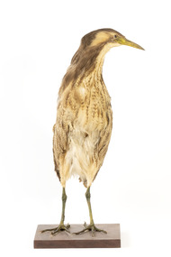
 The Beechworth Burke Museum
Animal specimen - Australasian Bittern, Trustees of the Australian Museum, 1860-1880
The Australaisn Bittern is a partly nocturnal bird who resides in costal and sub-coastal locations in south-west mainland Australia, south east Australia and Tasmania. They can be found in wetlands, swamps and among reeds. These birds are mostly brown and yellow in colour and with short legs and a stocky body. The "woomph" sound made by the Bittern late at night is thought to have been the origin of the traditional Aboriginal myth of the Bunyip. The Bunyip, like the Australasian Bittern, was believed to reside in reedy swamps. This specimen is part of a collection of almost 200 animal specimens that were originally acquired as skins from various institutions across Australia, including the Australian Museum and the National Museum of Victoria, as well as individuals such amateur anthropologist Reynell Eveleigh Johns between 1860-1880. These skins were then mounted by members of the Burke Museum Committee and put-on display in the formal space of the Museum’s original exhibition hall where they continue to be on display. This display of taxidermy mounts initially served to instruct visitors to the Burke Museum of the natural world around them, today it serves as an insight into the collecting habits of the 19th century. This specimen is part of a significant and rare taxidermy mount collection in the Burke Museum. This collection is scientifically and culturally important for reminding us of how science continues to shape our understanding of the modern world. They demonstrate a capacity to hold evidence of how Australia’s fauna history existed in the past and are potentially important for future environmental research. This collection continues to be on display in the Museum and has become a key part to interpreting the collecting habits of the 19th century.The Australaisn Bittern is a stocky bird with mainly yellow and brown colouring. This colouring makes the bird difficult to see in the dense, reedy vegetation where it resides amongst the shallow freshwater wetlands. When threatened, the Australaisn Bittern will raise it's bill skyward in a pose which helps it to camouflage. This specimen has streaked yellow-brown feathers, a yellow bill and legs which are a yellow-green colour. It stands on a wooden platform.Paper tag: ...Bittern... [Catalogu]e, page 3...taxidermy mount, taxidermy, animalia, burke museum, beechworth, australian museum, skin, reynell eveleigh johns, bird, bunyip, myths, australaisn bittern, bittern -
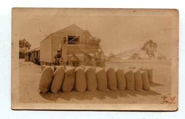 Orbost & District Historical Society
Photograph, 1930s
Maize has been grown on the Orbost flats for at least 70 years. When early settlers began to arrive on the Snowy River somewhere in the 1880s, the land was mostly swamps and heavily timbered jungle on the river frontages. The swamps were drained, bit by bit, with short handled shovels working in mud and water. The frontages were cleared by axe and shovel and fire. Several kinds of crops were experimented with such as hops, hemp and maize which grew particularly well and became the main crop of district. The problem then was to thresh and deliver the product to the market. A small single cob machine was brought here and one man turned the handle, while the boy or Mum fed the cobs singly into the machine. A good day’s work would thresh about 50 bushels or about 12 bags (4 bushels). The task then was to cart the maize to market. For a few years this was done by horses and dray carrying about 60 bushels to Mossiface, where it was loaded onto river boats to Lakes Entrance, and then by ocean boats to Melbourne. (information from NEWSLETTER OCTOBER, 2006)The growing of maize in the Orbost district contributed significantly to the economy of the township for many years, The many maize cribs once seen on the surrounding farms have now disappeared and this photograph is a pictorial record of that significance.A small sepia photograph with six men in front of a wooden barn. They are bagging maize. In the foreground are two rows of filled bags. On the right is a lifting machine to take the bags to the top storey. On the far right is a water tank on a stand"on back - "Thrashing Maize"maize-orbost agriculture-maize industry -
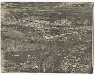 Melbourne Legacy
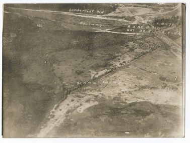
Photograph - Photo, Aerial view of the Somme
An aerial photo of the Somme Swamp in France during World War One. There are coordinates or numbers in some areas. Was with 11 other photos of World War One that had been mounted on board for display at Legacy House at some stage. When they were taken off display they were put in the archive cabinets. The founding legatees all served in World War One so these photos would have been of significant places for them. (see 01888 to 01899)Photos from World War One that would have been significant to the founding legatees.Sepia photo of the Somme battlefield in France during World War One.world war one, france, somme -
Ballarat Heritage Services
Work on paper - Printmaking - Silkscreen, Fruit Bats by Roy Burnyila
Roy BURNYILA (31/12/1954- ) Skin name: Bangardi Language: Ganalbingu Dreaming: Yirritja Clan: Gurrumba Gurrumba Region: Arnhem Land Burnyila learnt to paint from his father. The Arafura Swamp and personal totems such as the Yalman (water lilies), Gumang (magpie geese), Warrnyu (flying fox), Banda (Longneck turtles) and Bapi (snakes) are featured inhis work. Burnyila is renowned for his single coloured lined rarrk (cross hatching). Screenprint of fruit bats, printed in colour inks, from multiple stencils. The work features cross hatching (rarrk).roy burnyila, aboriginal -
 Bendigo Historical Society Inc.
Photograph - HARRY BIGGS COLLECTION: BOORT CEMETERY
Poor quality black and white photo of Boort Cemetery showing a grave head to the left and one in the foreground laying down. Photo shows a row of trees in the distance. Inscription on the back of photo 2400 415a. Graves inside the swamp (Lake Boort). G Campion - a young Englishman who came for Colonial experience 'on Boort' when it was held by Mr F. R. Godfrey (1846 to 1856?) also a child of the married couple on the station who died and was buried on the day Campion buried the child of H. Godfrey and another baby of a married couple.memorials, graveboards, boort cemetery, boort cemetery -
Glen Eira Historical Society
Document - Riddell Parade, 48, Elsternwick
Two items about this property: 1/A typed Research report on the history of the property at 48 Riddell Parade, Elsternwick, built in 1916/1917 on a subdivision of John Carre Riddell’s land. Prepared by Hilary Bullock and Rosalind Landells of the Brighton Historical Society, dated 14/08/1992. Includes a list of past owners and residents of the property. Their handwritten working notes, undated, are also included. 2/A plan of the subdivision of Riddell Estate from Sand Swamp and Heath (photocopy).cavers carre, riddell john carre, elsternwick, riddell parade, weedon james, walker alice o mrs, foley christina mrs, foley aileen c dr, 'carmel', house names, mcmillan archibald, mcmillan street, 'sand swamp and heath', carre street, gisborne street, landells rosalind, bullock hilary -
 Kew Historical Society Inc
Map, Robert Russell, Map Shewing the Site of Melbourne and the Position of the Huts & Buildings Previous to the Foundation of the Township by Sir Richard Bourke in 1837
Map shows the first layout of Melbourne by Government surveyor Robert Russell, who accompanied Governor Richard Bourke in 1837. The surveyed blocks extend from present-day Flinders Street to Lonsdale Street, and Spring Street to Spencer Street, with extensive vacant land west to a salt lake (afterwards Batman's Swamp, later drained), north beyond Flagstaff Hill and south towards South Melbourne. Vegetation coverage is indicated, and tracks and existing buildings and cultivated land are shown.Printed map was created by Day & Haghe, Lithographers to the Queen, sometime after 1838, when the company received its Royal appointment. Copies of the 1837 map exist in several major map collections in Australia; most are uncoloured. This particular map is the earliest in the Kew Historical Society's map collection. It is a nationally significant artefact. Black and white lithographed map hand-coloured in blue and yellow gouache of the town of Melbourne in 1837. In contrast to the original lithograph, the river and the township blocks are coloured blue and yellow. A similar, partly coloured copy is in the collection of the University of Melbourne.maps - melbourne - 1830s, governor sir richard bourke, robert russell - surveyor, cartography -
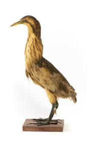
 The Beechworth Burke Museum
Animal specimen - Australasian Bittern, Trustees of the Australian Museum, 1860-1880
The Australaisn Bittern is a partly nocturnal bird who resides in costal and sub-coastal locations in south-west mainland Australia, south east Australia and Tasmania. They can be found in wetlands, swamps and among reeds. These birds are mostly brown and yellow in colour and with short legs and a stocky body. The "woomph" sound made by the Bittern late at night is thought to have been the origin of the traditional Aboriginal myth of the Bunyip. The Bunyip, like the Australasian Bittern, was believed to reside in reedy swamps. This specimen is part of a collection of almost 200 animal specimens that were originally acquired as skins from various institutions across Australia, including the Australian Museum in Sydney and the National Museum of Victoria (known as Museums Victoria since 1983), as well as individuals such as amateur anthropologist Reynell Eveleigh Johns between 1860-1880. These skins were then mounted by members of the Burke Museum Committee and put-on display in the formal space of the Museum’s original exhibition hall where they continue to be on display. This display of taxidermy mounts initially served to instruct visitors to the Burke Museum of the natural world around them, today it serves as an insight into the collecting habits of the 19th century.This specimen is part of a significant and rare taxidermy mount collection in the Burke Museum. This collection is scientifically and culturally important for reminding us of how science continues to shape our understanding of the modern world. They demonstrate a capacity to hold evidence of how Australia’s fauna history existed in the past and are potentially important for future environmental research. This collection continues to be on display in the Museum and has become a key part to interpreting the collecting habits of the 19th century. This Australaisn Bittern is a stocky bird stylised in a standing position with brown colouring. This colouring makes the bird difficult to see in the dense, reedy vegetation it resides amongst in shallow freshwater wetlands. When threatened, the Australaisn Bittern will raise its bill skyward in a pose which helps it camouflage. This specimen has streaked yellow-brown feathers, a yellow bill and legs which are a yellow-green colour. It stands on a wooden platform.taxidermy mount, taxidermy, animalia, burke museum, beechworth, australian museum, skin, reynell eveleigh johns, bird, bunyip, myths, australaisn bittern, bittern -
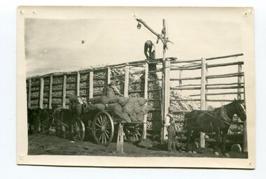 Orbost & District Historical Society
black and white photograph
Maize,has been grown on the Orbost flats for at least 70 years. When early settlers began to arrive on the Snowy River somewhere in the 1880s, the land was mostly swamps and heavily timbered jungle on the river frontages. The swamps were drained, bit by bit, by men with short handled shovels and working in mud and water. The frontages were cleared by axe and shovel and fire. Several kinds of crops were experimented with such as hops, hemp and maize, the latter grew particularly well and became the main crop of district. The problem then was to thresh and deliver the product to the market. A small single cob machine was brought here and one man turned the handle, while the boy or Mum fed the cobs singly into the machine. A good day’s work would thresh about 50 bushels or about 12 bags (4 bushels). The task then was to cart the maize to market. For a few years this was done by horses and dray carrying about 60 bushels to Mossiface, where it was loaded onto river boats to Lakes Entrance, and then by ocean boats to Melbourne. Later it was taken to Bairnsdale by foot and loaded onto the trains to Melbourne. (more information in Newsletter October 2006)The growing of maize in the Orbost district contributed significantly to the economy of the township for many years, The many maize cribs once seen on the surrounding farms have now disappeared and this photograph is a pictorial record of that significance.A black / white photograph of a man unloading maize from a horse-drawn wagon into a maize crib. Another man is standing by the horse.maize-crib-orbost agriculture maize-corn-orbost -
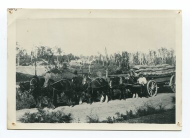 Orbost & District Historical Society
black and white photograph, late 19th century - early 20th century
Maize, or corn as it is called in America and New South Wales, has been grown on the Orbost flats for at least 70 years. When early settlers began to arrive on the Snowy River somewhere in the 1880s, the land was mostly swamps and heavily timbered jungle on the river frontages. The swamps were drained, bit by bit, by stout hearted men with short handled shovels and working in mud and water. The frontages were cleared by axe and shovel and fire. Several kinds of crops were experimented with such as hops, hemp and maize, the latter grew particularly well and became the main crop of district. The problem then was to thresh and deliver the product to the market. A small single cob machine was brought here and one man turned the handle, while the boy or Mum fed the cobs singly into the machine. A good day’s work would thresh about 50 bushels or about 12 bags (4 bushels). The task then was to cart the maize to market. For a few years this was done by horses and dray carrying about 60 bushels to Mossiface, where it was loaded onto river boats to Lakes Entrance, and then by ocean boats to Melbourne. ( from NEWSLETTER OCTOBER, 2006) This is a pictorial record of farming practices in Orbost in the early 20th century.A black / white photograph of a horse team hauling a wagon loaded with bags of maize.A man is sitting on the edge of the wagon.farming-orbost agriculture maize corn transport -
Federation University Historical Collection
Book, C.E. Bristow, Government Printer, Northern Territory of South Australia Government Geologist's Reports on Recent Mineral Discoveries, 1908
Foolscap government geologist's Report including information on:- Pine Creek District; Brock's Creek, Anson Bay, Northern Territory Boring Operations Images Include: 'Mob of Blacks ad Tamarind Tree near Cliff Head, Anson Bay; Diamond Drill Boring Camp, near Cliff Head, Anson Bay, Wannomi Swamp; Daly River Crossing; Battery and Chinese Miners, Driffield Sketch Plan of the Mount Davis Copper FIeld, Sketch Plan Shewing POsition of Mineral Localities and Claims Near Wolfram Camp, Sketch PLan of the Pin Creek District Shewing Metalliferous Localities. h.y.l. brown, mining, boring, aborigines, aboriginal, chinese, south australia -
 Bendigo Historical Society Inc.
Drawing - NORMAN PENROSE COLLECTION: BROWN FOLDER, 1955
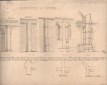
Artwork. Norman Penrose collection: large brown folder with wide black spine containing a page from Water Life with coloured sketches of the Murray Cod, the Azure Kingfisher and the Swamp-hen. A page from the Herald-Sun, Feb 13, 1955 with ladies shoes on one side and the third article of a series of Lawrence of Arabia on the other. Notes and drawings of Ionic Order (Erectheion - Athens. North Portice). And Doric Order (Temple of Theseus. Athens. 5th Cent BC). Also Corinthian Order (Choragic Monument of Lysicrates. Athens). Plan of the Parthenon. Notes on perspective. Notes and illustrations on the Development of Buttress.drawing, pencil, norman penrose collection, water life, notes on drawings, herald-sun, ionic order, corinthian order, doric order -
Glen Eira Historical Society
Article - Rockbrook Road, 16, St Kilda East
Two items about this property and environs: 1/Photocopy of a typed document, dated 29/02/1988, written by Hilary Bullock and Rosalind Landells of Brighton Historical Society, detailing the history and owners and occupiers of 16 Rockbrook Road, St Kilda East. Accompaying it is a handwritten working note of same with the information coming from 'Sand Swamp and Heath'. 2/A Wikipedia article with Bibliography of James Service, joint owner of Rock Brook, St Kilda East (article last modified 01/10/2009).rockbrook road, 'rock brook', gardiner william, st kilda east, the argus, stevenson william, hotham street, caulfield, taylor percy w., balaclava road, service street, brosnan john c., glen eira road, service james, brosnan l.c. mrs., brosnan m miss, vafeas g., bullock hilary, landells rosalind., industrial workers, merchants, commerce, sports and recreations, journalists, newspapers, roads and streets, houses, premiers, parliamentary representatives, land subdivision, house names -
Glen Eira Historical Society
Letter - MARRIOTT FAMILY
This file contains three items of this family’s correspondence 1/A Carbon copy page giving details of Robert and John Marriott and John Long, from their arrival in Victoria. Includes brief history of their lives becoming councillors for the city of Caulfield. Also Robert’s early market garden business in the area, and how he established Camden Town Methodist Church. 2/A handwritten letter to Mr. Murray from Catherine Marriott dated 29th Oct (no year) 3/A Two handwritten pages of working notes in Peter Murray’s writing, author for ‘Sand, Swamp and Heath’.marriot robert, long john, gold, caulfield, councillors, st. kilda, hawthorn road, alexandra hospital, hospitals, flowers street, laura street, glen huntly road, marriot john, bambra road, field street, goe street, market gardeners, bentleigh, marriott thomas, methodist church, sunday schools, camden, hawthorn road, indoor bowling club, sporting clubs, lewis bobby, jockeys, marriott catherine, marriott arthur, hughes d, blanche mrs., stables, kooyong road, ricketson h, mallinson j, kunney m, evans john, grange road, millar w, nyora road, rate book -
 Melbourne Legacy
Photograph - Photo, Aerial view of the Somme
An aerial photo of the Somme Swamp in France during World War One. There are coordinates or numbers in some areas. Also labelled are the railway line and Canal du Nor and Limberlost Wood. Was with 11 other photos of World War One that had been mounted on board for display at Legacy House at some stage. When they were taken off display they were put in the archive cabinets. The founding legatees all served in World War One so these photos would have been of significant places for them. (see 01888 to 01899)Photos from World War One that would have been significant to the founding legatees.Sepia photo of the Somme battlefield in France during World War One.world war one, france, somme -
 Warrnambool and District Historical Society Inc.
Administrative record - Jill Heathcote Album and Folder, Jill Heathcote, Dennington, Jill Heathcote Collection, Second half of 20th century
The album is a collection of items of interest, mainly newspaper cuttings, from 1982, 1983 and 1984. The folder contains information and records relating to the Warrnambool Bird Observers' Group and includes records relating to Lake Pertobe, Tower Hill, The Maam, Kelly's Swamp, Nirranda, Allansford, Timboon, and Port Fairy. They were collected by Jill Heathcote (1927-2011), a Dennington resident who was for many years a member of the Warrnambool and District Historical Society, the Warrnambool Bird Observers' Group and the Warrnambool Field Naturalists Group. The cuttings and bird records reflect her interest in both local history and natural history. These two items are of considerable interest, particularly to those interested in local natural history. The scanning of the items has been completed.1. One brown plastic folder sold commercially for the storage of photographs and documents. The cover has an ornamental gilt border. The folder contains 24 cardboard pages and plastic sheets. The pages are bound with two metal screws. There are 77 items stored in this folder, most of them being newspaper cuttings dealing with natural history from 1982-3-4. The collector of the items in the folders was Jill Heathcote. 2. Black folder containing handwritten notes, articles, charts and typed listsjill heathcote, natural history, warrnambool -
 Seaworks Maritime Museum
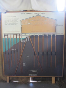
Diagram
Cross section of wharves and steel framed sheds built along the Yarra river between the 1920s and 1960s. The South Melbourne side of the Yarra River is reclaimed swamp land. Without a solid foundation for the construction of the wharves and transit sheds, extended piles were sunk into the mud to support the wharf and shed structures. An example of this design may be found at 5 South Wharf which was built in the 1930s. The transit sheds gave shelter for cargo while waiting to be loaded onto a ship or to be collected by truck after being unloaded from a ship. The transit shed became surplus to requirements with the introduction of containers.Wooden diagram of a transit shed featuring a shed sitting atop mud with some water. It shows the splices sitting in the mud to support the shed. "Steel Frames Transit Shed/ 15 South Wharf/ Model of Typical wharf construction/ of 1940- made for the opening of/ the "new" 15 South wharf shed (1944),/ Note the deep piles and elevated/ rear of the shed to allow for the truck/ trays./ This shed feature disappeared/ from port construction with the/ coming of the container era/ reinforced wharf apron/ 3 ton travelling crane/ reinforced concrete shed floor/ concrete road/ water level/ concrete pile cap/ cradled piles/ timber pile splices/ mud/ mild steel pile splices/ 110 ft pile" "On loan from Port of Melbourne Authority" -
 Orbost & District Historical Society
black and white photograph, Vogt, Stanley, 1918
Maize,has been grown on the Orbost flats for at least 70 years. When early settlers began to arrive on the Snowy River somewhere in the 1880s, the land was mostly swamps and heavily timbered jungle on the river frontages. The swamps were drained, bit by bit, by men with short handled shovels and working in mud and water. The frontages were cleared by axe and shovel and fire. Several kinds of crops were experimented with such as hops, hemp and maize, the latter grew particularly well and became the main crop of district. The problem then was to thresh and deliver the product to the market. A small single cob machine was brought here and one man turned the handle, while the boy or Mum fed the cobs singly into the machine. A good day’s work would thresh about 50 bushels or about 12 bags (4 bushels). The task then was to cart the maize to market. For a few years this was done by horses and dray carrying about 60 bushels to Mossiface, where it was loaded onto river boats to Lakes Entrance, and then by ocean boats to Melbourne. Later it was taken to Bairnsdale by foot and loaded onto the trains to Melbourne. (more information in Newsletter October 2006) This crib, measuring seven chains, sixteen feet, contained 10,000 bags of maize cobs which were grown by Linc Timmons on Peter Irvine's farm (Fairlea?) in Orbost, East Gippsland. The growing of maize in the Orbost district contributed significantly to the economy of the township for many years, The many maize cribs once seen on the surrounding farms have now disappeared and this photograph is a pictorial record of that significance.A black / white photograph of a large maize crib full of maize in a paddock. There is a large framed copy of the original.agriculture-orbost farming-maize-orbost maize-crib-orbost -
Federation University Historical Collection
Document, Articles on the Bunyip, 1983 - 1989
The bunyip is a large mythical creature from Aboriginal mythology, said to lurk in swamps, billabongs, creeks, riverbeds, and waterholes. The origin of the word bunyip has been traced to the Wemba-Wemba or Wergaia language of Aboriginal people of South-Eastern Australia. However, the bunyip appears to have formed part of traditional Aboriginal beliefs and stories throughout Australia, although its name varied according to tribal nomenclature. Various written accounts of bunyips were made by Europeans in the early and mid-19th century, as settlement spread across the country. (http://en.wikipedia.org/wiki/Bunyip) This material was collected and used for resarch purposes by David Waldron A number of articles on the Bunyip * The Nessie Mystery Solver by Roy Fraser (October 1983) * Developers meet match (Wagyl) (The Age, 06 Jan 1989) * Narrandera's bunyips burst into tourism's limelight by Melanie Sincock (wagga Advertiser, 18 November 1986) * Hunting the bunyip by M.A. Troyahn (Australiasian Post, 06 October 1883) * Beware the bunyip, you Moomba skiers by Edel Wignell (The Age, 05 March 1982) * The yarn that grew the bunyip legend (Australasian Post, 30 December 1971) australian animal folklore collections, bunyip, bunyipswagyl, shane picket, narrandera, swan river, david waldron -
City of Kingston
Photograph - Colour, 29 January 1993
Bonbeach is a small beachside suburb located between Chelsea and Carrum. The station was opened in 1926 and was the last to be established in the group from Aspendale to Carrum. Urban growth began after World War II. State primary and high schools were opened in 1958 on land in Breeze Street that was once occupied by The Australian Glass Manufacturers. Immediately east of the school sites is the Patterson River Golf Club. The Bonbeach sports reserve has five ovals and is home to the Bonbeach football and baseball clubs. The suburb borders the Edithvale-Seaford Wetlands which is the remnant site of the Carrum Carrum swamp, once the home of the Bunurong people.Bonbeach was originally a seaside destination for holidaymakers and the housing comprised of holiday homes and gradually more permanent residents. It was not until 1926 that Bonbeach had its own railway station. From 1906 until the late 1940s sand was quarried on the east side of the railway line and used in the manufacture of glass. The Australian Glass Manufacturers sold this land in residential blocks and Bonbeach's permanent population spread from the coastal strip across to the other side of the railway line. Laminated colour aerial photograph of the suburb of Bonbeach and also the southern section of neighbouring Chelsea within the City of Kingston. The extent of this 1993 aerial image includes: Top left - Maury Road at the south end of the Chelsea shopping Centre; Top right - Scotch Parade Chelsea Bottom left - Monica Avenue in Bonbeach; Bottom right - Patterson River Golf Club. Landmarks include St Joseph's Church and Primary School, Chelsea Primary School, Bonbeach Station, Bonbeach Fotball Club sports playing fields and Bonbeach Life Saving Club. The Edithvale Wetlands is featured prominently to the right-hand side of the image. Black typed writing on white adhesive label: No. 6662 Black typed writing on white adhesive label: 26E/6662, 29/1/93, 4.25 pm Black typed writing on white adhesive label: 29-1-93 Black typed writing on white adhesive label: P000109 Circular yellow adhesive sticker bonbeach, chelsea