Showing 116 items matching "the geography of victoria"
-
 Tarnagulla History Archive
Box of Donald Clark's Research Notes, Donald Clark's Research Notes, circa 1960s-2000s
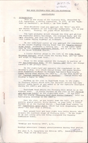
Donald Clark Collection. Blue-grey archive box containing research notes of Donald Clark. Within this set are multiple archival folders with the following subject matter: Hotels Gold, prospecting & mining Peace Picnic Street lighting Churches Cemetery Poems Shire of Bet Bet Chinese Clubs Police Transport Local businesses/premises Local people Post Offices Previous history work / previous history enquiries Back To Tarnagulla events Victoria Theatre / Entertainment Schools Water and waterways Early town Mapping and geography Photocopies of photos Miscellaneous Rail Link Centenary Newbridge Eddington Waanyarra Bet bet (town) Llanelly Murphy's Creek / Irishtown Laanecoorie Military Service Fire Brigade Tarnagulla Landmarks / Places of Interest Family Histories Births, Deaths, Marriage info Transcript of St. Saviour's Records A plastic pocket containing duplicate copies of local history images held elsewhere in the collection. The contents of these files were research notes compiled by Donald Clark from his local history research about Tarnagulla and district. tarnagulla & district, donald clark, research -
 Wodonga & District Historical Society Inc
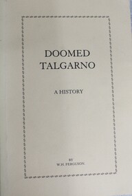
Book - Doomed Talgarno - A History, W. H. Ferguson, C. 1920 - 1929
... of the township of Talgarno in North Eastern Victoria, its geography ...A detailed study of the township of Talgarno in North Eastern Victoria, its geography and pioneering families. In the mid-1930s Talgarno’s river flats were inundated by the development of Lake Hume.non-fictionA detailed study of the township of Talgarno in North Eastern Victoria, its geography and pioneering families. In the mid-1930s Talgarno’s river flats were inundated by the development of Lake Hume.talgarno, pioneers north east victoria, lake hume -
 Greensborough Historical Society
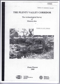
Book, The Plenty Valley Corridor: the archaelogical survey of historic sites, by Fiona Weaver, for the Ministry of Planning & Environment, 1989_
The Victorian Archaelogical Survey managed this study onbehalf of the Ministry for Planning & Environment. The study was intended to provide a brief history of Aboriginal and European occupation and use of the area and an outline of the geography of the chief areas of cultural heritage concern, with recommendations for protection of significant cultural sites and recommendations for further research, survey and consultation.115 p., photocopy, unbound. Illus., mapsplenty river, fiona weaver, victorian archaeological survey -
 Bacchus Marsh & District Historical Society
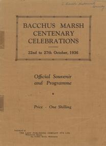
Book, Bacchus Marsh centenary celebrations, 22nd to 27th October, 1936: Official souvenir and programme, 1936
A souvenir booklet produced in Bacchus Marsh to commemorate 100 years since the arrival of European colonists in the district Bacchus Marsh in 1836. It contains a brief history of European settlement in the area and a description of some of the major industries and infrastructure of the region. Also included are several black and white images of significant local buildings, parks, geographic features and a group portrait of shire councilors; Published by The Lady Publishing Company, Melbourne, 1936. Edited by F. C. McC Crisp; Online edition accessible from State Library of Victoria at: https://find.slv.vic.gov.au/permalink/61SLV_INST/1sev8ar/alma99837471360763628 pages. 25cm. BMDHS Location: AR/SU4non-fictionA souvenir booklet produced in Bacchus Marsh to commemorate 100 years since the arrival of European colonists in the district Bacchus Marsh in 1836. It contains a brief history of European settlement in the area and a description of some of the major industries and infrastructure of the region. Also included are several black and white images of significant local buildings, parks, geographic features and a group portrait of shire councilors; Published by The Lady Publishing Company, Melbourne, 1936. Edited by F. C. McC Crisp; Online edition accessible from State Library of Victoria at: https://find.slv.vic.gov.au/permalink/61SLV_INST/1sev8ar/alma998374713607636bacchus marsh history, centenaries bacchus marsh -
 Federation University Historical Collection
Book, The Plants Indigenous to the Colony of Victoria, 1865 (exact); "1864-1865, CR"
Baron Sir Ferdinand Jacob Heinrich von Mueller was born in Germany on 30 June 1825. Ferdinand was a German-Australian physician, geographer, and a botanist. After passing the pharmaceutical examinations he studied botany at Kiel University. In 1847 he received the degree of Doctor of Philosophy from Kiel University.when he was 21 years old for a thesis on the flora of Schleswig-Holstein. In 1847, he moved to Adelaide, Australia and worked as a chemist. From 1848 to 1852 he travelled through the colony, discovering and describing a large number of unknown to Western science plants. He wrote a few papers to German periodicals on botanical subjects. In 1851, Mueller moved to Melbourne, capital of the new colony of Victoria. In 1853, He was appointed Government Botanist for Victoria by Governor Charles La Trobe. In 1873, Ferdinand received an honorary doctorate of the University of Rostock. In 1883, he was awarded the Clarke Medal by the Royal Society of New South Wales. He published many volumes on the Victorian plants. Many of Australian geographical features were named after him such as: the Mueller Ranges (WA), Muellers Range (Qld), Mount Mueller (in WA, NT, Tas and Vic) and many more. Mueller died in Melbourne on 10 October 1896 and is buried in the St. Kilda Cemetery A green cloth hard cover book. Title and author's name is engraved in gold on spine. It includes an introduction, a table of contents and plates. Lithograms in b/w. Each plate accompanied by a page with descriptive print. Number of plates XIII-LXXI. No. of supplement plates XII-XVII. The book illustrates Victorian plants and outlines the principal characters of those species. This book is No 1290 in the Original Register of Books (Cat. No. 005)Hand written pencil notes on contents page. Stamped throughout with "The School of Mines, Industries & Science, Ballarat. Ingenio Effodere Opes. In the University of Melbourne."australia, botany victoria, plants, ferdinand mueller, ferdinand von mueller, biodiversity, flora -
 Falls Creek Historical Society
Booklet - Australian Ski Year Book 1981 Resort Guide
"The Australian Ski Year Book" was first published in 1928 by the Kosciusko Alpine Club and the Ski Club of Australia, which with the Kiandra Ski Club, were the oldest organisations for skiing in Australia. In later years organisations from Victoria, Tasmania and New Zealand were included. It was published on behalf of N.S.W. Ski Council, Ski Club of Victoria, Ski Council of Tasmania, Ski Council of the Federated N.Z. Mountain Clubs. It aimed to provide an annual record of the sport of ski running in Australia, and of events elsewhere which would be of interest to Australian ski enthusiasts. This publication was a guide to all major resorts operation at the time in New South Wales, Victoria and Tasmania. Information about Falls Creek included a description of its location describing geographical features, its 12 ski tows and available services. The accommodation advertised included Winterhaven Lodge, Falls Creek Motel, Spargo's Lodge, Attunga Alpine Lodge, Nelse Alpine Lodge, Les Chalets, Julian Lodge and Koki and Karelia Alpine Lodges.This item is significant because it is an issue of a long-running Australian ski publication which includes items about Falls Creek, Victoria..The Australian Ski Year Book Resort Guide of 1981 includes information and advertising about resorts throughout Australia. Falls Creek information and Accommodation Guide featured on pages 10 & 11 of this issue.australian skiing, accommodation falls creek, falls creek resort -
 The Beechworth Burke Museum
Geological specimen - Fossil Leaves
... information on the geographical profile of Victoria as fossilisation ...A fossil refers to any remains or traces of past life that are preserved in the rock. It could be remains of plants or animals. Fossil leaves are commonly found on different types of rocks. These fossils can go as far back as the Triassic Age just like the series of fossil plants collected at Denmark Hill, Ipswich in Queensland. Fossils leaves are formed when dead plants get buried by sediments like mud, sand, or volcanic ash. Often, it gets detached cleanly from stems along a special layer of weak cells, then twigs, and, less commonly, cones of conifers and fruits and seeds of flowering plants. Over time, the leaves or pieces of leaves get buried by more sediments and eventually gets 'lithified' or hardened into a rock. Erosions and mining can cause the rocks to break and reveal the fossils buried in it. Fossilisation frequently takes place at sites in the lowlands where deposits of clay, silt, sand are found. This is usually due to weathering and erosion of rocks. Fossil leaves can provide information about ancient Australia's way of living. It contributes to Victorian biodiversity records and its botanical collections. It also contributes information on the geographical profile of Victoria as fossilisation usually occur at estuaries and deltas of rivers, river flood plains, ponds and lakes. This specimen is part of a larger collection of geological and mineral specimens collected from around Australia (and some parts of the world) and donated to the Burke Museum between 1868-1880. A large percentage of these specimens were collected in Victoria as part of the Geological Survey of Victoria that begun in 1852 (in response to the Gold Rush) to study and map the geology of Victoria. Collecting geological specimens was an important part of mapping and understanding the scientific makeup of the earth. Many of these specimens were sent to research and collecting organisations across Australia, including the Burke Museum, to educate and encourage further study.Piece of light brown rock with fossilised leaves in shades of golden yellow and brown.Existing label: Fossil Leaves / Locality unknown / might be worth checking if this is Glossopteris, a Permian age plant. / C. William 16/4/21 geological specimen, geology, geology collection, burke museum, beechworth, fossil leaves, fossilization, 1868 geological survey of victoria, lithified, rocks, fossilised leaf, rock, fossils, leaves -
 Merbein District Historical Society
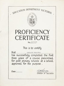
Certificate - Proficiency Certificate
Proficiency certificate A4 certificate No 107909Front education department Victoria logo in oval with coat of arms and crown Proficiency certificate NO 107909 This is to certify that Penelope Treadwell has successfully completed the first three years of a course prescribed for post primary schools at a school approved for the purpose director of education Back the candidate has completed a course of study in the following subjects with results as indicated English pass, algebra pass, geometry pass, geography pass, general science pass agricultural science, French credit pass , German, Latin, history pass, social studies , musical appreciation, art credit pass, shorthand, home management including cookery, needle work credit pass, crafts, woodwork, metalwork, blacksmithing, mechanical drawing, physical education pass. education, penelope treadwell, proficiency certificate -
University of Melbourne, Burnley Campus Archives
Book - Report, E.B. Littlejohn, Victoria 1944 State Regional Boundaries Committee Report on Regional Boundaries, 1944
See paper catalogue for complete contents. Item formerly property of E.B. LittlejohnReport includes maps of Regions for Planning and Development, geographical, weather, power, water resources, crops, livestock, etc.e.b. littlejohn, planning, development, regions -
 Mont De Lancey
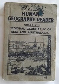
Book, Whitcombe & Tombs Limited, Whitcombe's Human Geography Reader Grade VIII - Regional Geography of Asia and Australasia, c 1930's
... , Victoria. children's books handbooks textbooks geography A Human ...A Human Geography Reader for Grade VIII. Regional Geography of Asia and Australasia specially written to meet the requirements of the Social Studies (Geography) Course of Study in Victorian Schools. It stresses the necessity to win the interest of pupils and the important part geography has played in the history of the world. There is an emphasis on the regional study of Australasia.A small grey paperback reader or textbook with black lettering on the front cover at the top for the title Whitcombe's Human Geography Reader Grade VIII. A cost of 1/9 is printed in the lower right hand corner. A black and white illustration inside a square shape is of a city near a river and wharf activities. Throughout are black and white charts, maps, diagrams, photographs and illustrations. Inside the front and back covers are further Whitcombe and Tombs titles as well as on the outside of the back cover. Blue ink writing on the front of Lance Sebire. Some ink stains inside with a damaged worn cover and stains. 208p.non-fictionA Human Geography Reader for Grade VIII. Regional Geography of Asia and Australasia specially written to meet the requirements of the Social Studies (Geography) Course of Study in Victorian Schools. It stresses the necessity to win the interest of pupils and the important part geography has played in the history of the world. There is an emphasis on the regional study of Australasia.children's books, handbooks, textbooks, geography -
 Flagstaff Hill Maritime Museum and Village
Book - Textbook, Introduction to Modern Geography
... , Introduction to Modern Geography, explains geography and astronomy ...This mid-19th century scientific reference book, Introduction to Modern Geography, explains geography and astronomy using the globe of the world as a teaching aid. The inscription connects this book to the Bobinawarrah Public Library but research to date has found no further details about the library. The rural area was settled in 1859, but in 2016 its population was only 87. It is situated about 21 kilometres south of the City of Wangaratta, in Northeast Victoria. In 2024 the local community received a grant for preservation of its almost 100-year-old Bobinawarrah Memorial Hall which displays an honour board of the Pioneers of Bobinawarrah 1859-1959. The donor of the book lived in Warrnambool. ABOUT THE AUTHOR, James Thomson (1786-1849): - James Thomson was a British Irish mathematician. He became Professor of Mathematics at the University of Glasgow. He wrote many school textbooks and reference books, one of which was Introduction to Modern Geography, first published in Belfast in 1827, and revised and published in over 20 more editions. Thomson tutored two of his several children at home. His older son James Thomson (1822-1892) became an engineer and physicist. His younger son William Thomson (1824-1907) became Professor of Natural Philosophy from 1846-1899 at the University of Glasgow, and later the 1st Baron of Kelvin, famous for his designs of nautical instruments such as the navigational compass and sounding equipment used in the transatlantic installation of sea cable. William was part of the firm that became famous as Kelvin & Hughes Ltd., suppliers of radar and echo sounders to the Ministry of Transport and the Ministry of Defence. The name continued on as Kelvin & Hughes. James Thomson (1786-1849) was a renowned British Irish mathematician and Professor of Mathematics at the University of Glasgow. He was a respected author of many important school books and textbooks that were widely used to provide understanding of arithmetic and geography. Thomson encouraged practical education and held extra classes for young ladies to learn mathematics and geography, which were a novelty at that time. Many of his works were known and used worldwide. This work was published in many editions. It is now considered as culturally significant as a basis for knowledge about our civilisation and has been made publicly available in overseas countries, and republished and reproduced in a readable format, including its diagrams and maps. Book; scientific textbook. The book has a black leather cover. The front cover is blank, but the spine has an embossed gold vertical title within a rectangular border boasting fancy corners. The fly page has a detailed title. The author is James Thomson. It is the Eighteenth edition, published in Simms & McIntyre of London and Belfast in 1845. An inscription connects it to the Bobinawarrah Public Library in Victoria.Spine within a gold border: "THOMSON'S GEOGRAPHY" Fly Page: "AN INTRODUCTION TO MODERN GEOGRAPHY, WITH AN APPENDIX, CONTAINING AN OUTLINE OF ASTRONOMY, AND THE USE OF THE GLOBES. BY JAMES THOMSON, LL.D., PROFESSOR OF MATHEMATICS IN THE UNIVERSITY OF GLASGOW." "Eighteenth Edition" "LONDON: SIMMS AND McINTYRE, ALDINE CHAMBERS, PATERSOSTER ROW; AND DONEGALL -STREET, BELFAST.""1845"flagstaff hill, flagstaff hill maritime museum and village, warrnambool, maritime museum, maritime village, great ocean road, shipwreck coast, introduction to geography, james thomson, reference book, professor thomson's introduction to modern geography, bobinawarrah public library, james thomson mathematician, james thomson engineer, 19th century irish mathematician, irish presbyterian, william thomson 1st baron of kelvin, professor of mathematics, glasgow university, william thomson professor of natural philosophy, introduction to modern geography, outline of astronomy, use of the globes, james thomson ll.d., simms and mcintyre, 1843, scientific book, school book, lord kelvin, baron kelvin of langs, nautical instruments, marine instruments, transatlantic cable, kelvin & hughes, thomson’s geography, astronomy, geography, world globe, cartography, pioneers of bobinawarrah, textbook -
 Bendigo Historical Society Inc.
Document - VICTORIA HILL - RECOMMENDATION - MINING PROJECT
Two (a & b) typed copy of a recommendation for mining project, accepted Nov. 1967. Recommendation for Central Nell Gwynne area, now a public purposes reserve for preservation as a permanent reminder of the gold mining era. Victoria Hill Area mentioned for it's geographical and historical significance. The New Chum Hill area rich in historical and mining. Notes on development of the Central Nell Gwynne, Victoria Hill and New or Old Chum Hill areas. Notes prepared by Albert Richardson.mine, gold, victoria hill, victoria hill, recommendation - mining project, central nell gwynne, jack barker, victoria hill area, big 180, victoria quartz, new chum hill (old chum hill), p. m. g. repeater station, mine's department, land's department, lansell, fortuna, a h q survey regiment, lazarus mine, b c v 8 television studio -
 Bendigo Historical Society Inc.
Document - VICTORIA HILL - CLASSIFICATION REQUEST
Handwritten, 3 page carbon copy of a classification request for victoria Hill. Notes give locality, housing program in the area, immediate surrounds of the area, prominent citizens, buildings, mines, geographical formations and gold production. Notes prepared by Albert Richardson.mining, parish map, victoria hill, classification request for victoria hill, gold mines hotel, john brown knitwear factory, lansell's fortuna villa, army survey corp, housing commission, hercules, energetic, ironbark, manchester arms hotel, bendigo goldfield, old miners homes, george lansell, sir george lansell, bendigo advertiser, theodore ballerstedt junior, mr c t c johann ballerstedt, mr wm rae, david sterry, adventure, wittscheibe's 'jewellers shop', luffsman & sterry's rich claim, ballerstedt open cut and mine, lansells 180, victoria quartz, rotary club of bendigo south, bendigo cemetry -
 Warrnambool and District Historical Society Inc.
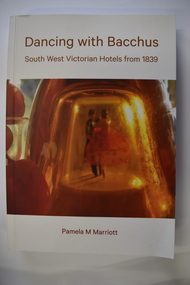
Book, Pam Marriott (publisher), Dancing With Bacchus, 2021
This book contains information on South West Victorian hotels from 1839This is a soft cover book of 348 pages. The cover has a white background with gold-coloured print, a red and orange image of dancers on the front cover and a photograph of liquor bottles and grapes on the back cover. The book contains a foreword, an index, printed text and black and white photographs.non-fictionThis book contains information on South West Victorian hotels from 1839 hotels in south west victoria, warrnambool history -
University of Melbourne, Burnley Campus Archives
Plan, Maplist: Catalogue of Victorian maps, 1984
Brochure showing all standard series mapping in Victoria available from Map Sales Centre as at October 1984. Includes: Geographic, Geological Planimetric, Aerial Photography, Photo Maps.maps, catalogue -
 Flagstaff Hill Maritime Museum and Village
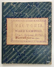
Book - School Exercise Book, 1898
The school exercise book belonged to Florence Tyler who was born in 1884 and died in 1914 at 30 years of age. Two letters within the exercise book are dated 1898 so it is presumed this is the year Florence compiled the book. The school was Warrnambool State School No. 1743 which opened in 1876 after the earlier Warrnambool Common School closed. This exercise book is of interest as an example of school subjects and standards covered at a 6th grade level in the late 19th century. A school exercise book of 50 pages. The hard cover of the book has a blue pattern and a label to identify the school and student. The pages are ruled with handwriting in black ink and ruled dividing lines in red ink. Each page covers a different subject - English (grammar, parsing, writing, spelling, syntax, poetry), Arithmetic, Geography, History, Science and Music. Each page has been stamped with a purple oval stamp containing the words CREDIT MARK and the initials W.W.Front Cover - VICTORIA. WARRNAMBOOL. STATE SCHOOL No. 1743. Florrie Tyler. 6th Classflagstaff hill maritime museum and village, great ocean road, shipwreck coast, warrnambool, warrnambool state school, school exercise book, 6th grade, warrnambool schools, education -
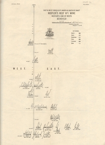
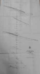 Bendigo Historical Society Inc.
Map - GREAT EXTENDED HUSTLER'S MINE - LONGITUDINAL SECTION OF THE GREAT EXTENDED HUSTLER'S MINE
Longitudinal Section of the Great Extended Hustler's Mine on the Hustler's Line of Reefs. Bulletin No 33, Plate No XIII. Map shows the Hustler's Tribute, 2 Old Shafts, Great Extended Hustler's Shaft, Latham & Watson's Shaft and Ironbark Gully. Datum Line 750 feet above Sea Level. Poppet Legs on the surface and Sill of Shaft 788.99 feet above Sea Level. Levels and their depths are shown and some geographical features. Some amounts of gold mined mentioned. Geological Survey of Victoria emblem and signed by H A Whitelaw, Underground Survey Office Bendigo, September 1913. Note - Plates 4, 8, 13,20, 26 & 31 form a Longitudinal Section from Fortuna Hustlers to Hustler's Consols Mine. mining, parish map, great extended hustler's mine, geological survey of victoria, underground survey office bendigo, h a whitelaw, hustler's tribute, old shaft, great extended hustler's shaft, latham & watson's shaft, ironbark gully -
 Bendigo Historical Society Inc.
Map - GREAT EXTENDED HUSTLER'S MINE - TRANSVERSE SECTION OF THE GREAT EXTENDED HUSTLER'S MINE
Transverse Section of the Great Extended Hustler's Mine on the Hustler's Line of Reef. Bulletin No 33, Plate No XII. Shows Poppet legs at the surface and Sill of Shaft at 788.99 feet above Sea Level, Cross Cuts and their depths, stone and geographical features encountered and their references and a number of enlarged drawing of sections of the crosscuts, Geological Survey of Victoria emblem and signed by H A Whitelaw, Underground Survey Office Bendigo, September 1913. The depths of crosscuts to No 21 were taken from plans of surveys by Mr. Walker and Mr. Craven, noted under Reference. Another note: This Saddle Reef is sketched from Mr. Walker's plan. Dividends amounting to 360,000 pounds were obtained from it. mining, parish map, great extended hustler's mine, transverse section of the great extended hustler's mine, old shaft, mr walker, mr craven, geological survey of victoria, underground survey office bendigo, h a whitelaw -
 Bendigo Historical Society Inc.
Document - VICTORIA HILL - THE RICH VICTORIA HILL AND ITS HISTORICAL ASSOCIATIONS
Copy and a photocopy of notes titled 'The rich Victoria Hill and its Historical Associations. The photocopy does not have copies of the photos. Notes include Introduction, directions for getting to Victoria Hill, North Old Chum Mine 2310 ft deep, Ballerstedt's First Open Cut, Geographical Features, Lansell's Big 180, Crushing Battery, Lansell's Cleopatra Needle type chimney, Victoria Quartz Mine 4613 ft deep, Victoria Reef Quartz Company, Victoria Quartz Company, Victoria Quartz Dams, Rae's Open Cut, Quartz Roasting, Floyd's small 5 Head Crushing Battery, Great Central Victoria (Midway) Shaft, Ballerstedt's Small 24 yard Claim, The Humboldt, The Adventure, The Advance and Luffsman and Sterry's Claim. Copies of photos include: Victoria Hill from Rae's Open Cut, Looking North from Old Chum Hill to the Victoria Hill, the Victoria Quartz Mine and Wm. Rae's Crushing Works.document, gold, victoria hill, the rich victoria hill and its historical associations, j n macartney, quartz miners' arms hotel, ironbark methodist church, john brown knitwear factory, little 180, george lansell, conrad heinz, british and american hotel, victoria reef gold mining company, manchester arms hotel, housing commission homes, the ironbark, hercules and energetic, midway, wittscheibe, great central victoria, wm rae, mr & mrs conroy, moorhead's shop, central nell gwynne, gold mines hotel, david chaplin sterry, new chum & victoria, old chum, burrowes & sterry, rotary club of bendigo south, big 180, north old chum mine, ballerstedt's first open-cut, lansell's bit 180 shaft, victoria quartz mine, victoria reef quartz company, a roberts & sons, mr e j dunn, h harkness & sons, new chum drainage scheme, eureka extended, new chum railway, the pearl, inrush of water, shamrock, shenandoah, victoria quartz dams, rae's open cut, floyd's small 5 head crushing battery, great central victoria (midway) shaft, midway no 2, midway north, the humboldt, the adventure, the advance, luffsman & sterry's claim, chinese joss house, fortuna, p m g repeater station, bendigo and vicinity 1895, j n macartney 1st edition 1871, mr rae anderson, 'gill family, annals of bendigo obituary notices 1904, mining records and australian mining standard special edition 1/6/1899, bendigo advertiser 22/6/1871, b m l records mines department, patterson's goldfields of victoria, dickers mining record 23/11/1861, annals of bendigo, bendigo advertiser 24/7/1933, 27/8/1908, 30/6/1910, 16/6/1910, 17/6/1910, mining reports for 1910, australian mining standard special edition 1/6/1899 p40, bendigo mines ltd, mines department records, the bendigo goldfield 1851 to 1954, the victoria hill 1854 to 1949, wm rae's crushing works -
 Bendigo Historical Society Inc.
Document - NEW CHUM & VICTORIA LINES OF REEF - THE NEW CHUM REEFS AND SOUTH VICTORIA
Handwritten notes on the New Chum Reefs (White & Black Leads) and South Victoria. Ref. Dicker's 23/11/1861 Pages 7 to 9. Notes include geography, Claims, Owners, Area & Title, Workings, Reef and Yield, Drainage and Remarks. Dates are 13/8/1861, 16/10/1861 and 11/9/1861. Also, a typed copy is includeddocument, gold, new chum & victoria lines of reef, the new chum reefs and south victoria, dicker's 23/11/1861 pages 7 to 9, bonatti's claim, gibbs & lazarus claim, phoenix company, south victoria, the black lead, messrs ballerstedt, garibaldi's company's claim, new chum company, m'dougall, inglis, menzies, dehan, the white lead, new chum quartz mining company, bonati and company, phillip bonati, woolcrow, albrecht, pragleman, mortinson, plumbreck, emmerling, sievis, denis's claim, messrs thompson and powell, geo denis, begelhole and company, mr begelhole, brown, blackwell, hildebrand & co, begelhole & co, w begelhole, thomas brown, henry begelhole, john blackwell, watson & co, j b watson, gibbs, lazarus, local court grant, gibbs & lazarus claim, mr gibbs, mr lazarus, phoenix company's claim, pioneer company, henry jackson, sullivan, burrows, chambers, marshall, william gunther, klemin, fulton, brown, brown, anderson, first quartz mining company, burrow's & co's claim, hudson's, thomas burrows, w philips, george hudson, john wybrant -
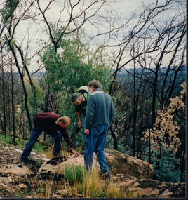 Wooragee Landcare Group
Photograph, 12th September 2004 or 15rh September 2004
This photograph was taken at Wooragee Landcare workshop (Quoll), field day in Mt Pilot park on Bush Recovery: After the Fires. This is part of the Biodiversity Month on September 2004. The Bush Recovery workshop was held on Sunday 12th September 2-4pm with Christine Watson, Sue Berwick and Natasha Schedvin, and another workshop on Wednesday, 15th September, 9am to 12 noon with local biologist Glen Johnson and botanists Gill Earl and Christine Watson. The topics involved in the training involved what species have returned, what species haven't, what recovery studies are being carried out, how are the barking owls and phascogales faring, and why is Mt Pilot important. The photograph shows L-R: Colin Payne; Jerry Alexander; Geoff Galbraith. Bush fires are common in Australia due to several reasons. One is due to the geographic spread of fire's seasons, secondly, the absence of El Nino conditions are also linked to fires. Climate change also affected Australia's hot and dry seasons. Australia's climate began warming since the 1970s. Human-induced fires also contributed to this increase in temperatures across the nation. Bush fires happened in Mt Pilot in 2003 but it has recovered well since. This makes Mt Pilot an important site to understand bushfire recovery. This photograph contributes to the scientific and historical records on bushfire recovery in Victoria. It creates a picture of Victorian community activities and efforts on biodiversity, climate change, and environmental care.Landscape coloured photograph printed on gloss paperReverse: WAN NA 0A2A0N0 NN2 0 163 / (No. 2)wooragee, wooragee landcare group, wooragee landcare, bush fires, bush recover, mt pilot, biodiversity month, botany, botanists, bush recovery, quoll, foxy, fox, forest, environment, climate change, bushfire recovery, bushfires, 2004 bushfire, field work, after the fires, fire, biodiversity -
 Bendigo Historical Society Inc.
Map - HUSTLER'S REEF & HUSTLER'S REEF NO 1 MINES - LONGITUDINAL SECTION OF THE HUSTLER'S REEF & HUSTLER'S
... Mines Geographical Survey of Victoria Underground Survey Office ...Longitudinal Section of the Hustler's Reef & Hustler's Reef No 1 Mines on the Hustler's Line of Reef. Bulletin No 33, Plate No XX. Note - Plates 4, 8, 13, 20, 26 & 31 form a Longitudinal Section from Fortuna Hustler's to Hustler's Consols Mine. Geological Survey of Victoria emblem. Signed by H A Whitelaw, Underground Survey Office Bendigo, September 1913. Shows the two shafts with their levels and depths. Also shows geographical features and yields of gold and amalgam per ton. .mining, parish map, hustler's reef & hustler's reef no 1 mines, geographical survey of victoria, underground survey office bendigo, h a whitelaw -
 Bendigo Historical Society Inc.
Map - HUSTLER'S REEF NO 1 MINE - EAST & WEST CROSS-CUTS OF THE HUSTLER'S REEF NO 1 MINE
Map showing the East & West Crosscuts, North & South of Shaft of the Hustler's Reef No 1 Mine on the Hustler's Line of Reefs Bulletin No 33, Plate No XXII. Drawing shows where the different levels are, the stone encountered and smaller drawings of other sections near the shaft. Also shows some geographical features. Signed by H A Whitelaw, Underground Survey Office Bendigo, September 1913. Geological Survey of Victoria emblem.mining, parish map, hustler's reef no 1 mine, geological survey of victoria, h a whitelaw, underground survey office bendigo, hustler's line of reefs -
 Federation University Historical Collection
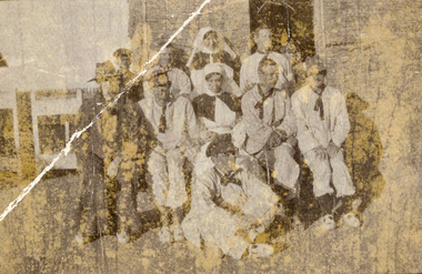
Photograph - postcard, S. Gordon Spittle, Australians at the World War One Suez Hospital, January 1916, c 07 January 1916
This photograph was with a number of others associated with Harry Holmes of Ascot, Victoria. The postcard was written on by Harry Holmes who was a member of the Australian Imperial Force based in Egypt at the time. Nurse Kirkham is Laurie Hemsley Kirkham She was admitted to the Suez Public Hospital (Abbassia) post 06 January 1916. She left Australia with a group of South Australian nurses. Egypt was a major base for the AIF from December 1914. A number of campaigns were fought in this theatre. There were two campaigns involving the AIF. Note that not all the fighting was actually geographically in Egypt. (http://www.aif.adfa.edu.au:8888/about3.html) The Nurse Kirkam mentioned by the writer is probably Sarah Alice Kirkham, Staff Nurse with the Australian Army Nursing Service. Nurse Kirkham was from North Perth, Western Australia. She was posted to the Auxiliary Hospital, Egypt on 09 November 1915 leaving for France on 23 June 1916. Samuel Gordon Spittle (8005) enlisted into the AIF on 17 July 1915, a member of the 18th Australian Army Service Corps (AASC). He left Alexandria on 15 June 1916 disembarking at Marseilles 24 June 1916. Harry Holmes was discharged from a hospital in Egypt on 15 August 1919. He was awarded the Military Medal promulgated on 11 December 1919. (NAA: B2455, Spittle Samuel Gordon) Not only does this photograph portray life in Egypt during World War War, it highlights the role played by members of the Australian Army Nursing Service in both professional and social activities in the theatre of war.Two Australian nurses and a number of Australian soldiers in Hospital Uniform pose for a photograph in Egypt during World War One. Verso: "A little group of Australians at Suez Hospital Joe F[awcett] & I [Gordon Spittle] are standing in the back row with Nurse Kirkham standing between, she is on the short side so stood on a box. Gordon S."chatham family archive, chatham, holmes, world war, world war 1, world war i, world war one, france, gordon spittle, kirkham, suez, egypt, samuel gordon spittle, joe fawcett, laurie kirkham, nurse kirkham, suez hospital, laurie helmsley kirkham, l.a. kirkham, harry holmes, nurses, ascot -
 Federation University Historical Collection
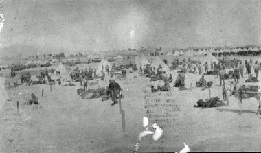
Photograph - black and white, Harry Holmes, Australian Soldiers Breaking Camp at Metras, c1916
The postcard was sent by Harry Holmes who was a member of the Australian Imperial Force based in Egypt at the time. He sent a number of postcards home to his family in Ascot, Victoria. Egypt was a major base for the AIF from December 1914. A number of campaigns were fought in this theatre. There were two campaigns involving the AIF. Note that not all the fighting was actually geographically in Egypt. (http://www.aif.adfa.edu.au:8888/about3.html) This photograph is significant because it was taken by a soldier (rather than an official war artist) and shows one of the daya to day activities experienced by Australian Soldiers in Egypt during World War One.A number of tents and soldiers in a dry landscape. They are Australian Soldiers At Metras, Egypt during World War One. Verso: 'Breaking Camp at Metras prior to making our departure from there on March 28th.'chatham family archive, chatham, holmes, harry holmes, world war, world war 1, world war one, world war i, metras, egypt -
 Falls Creek Historical Society
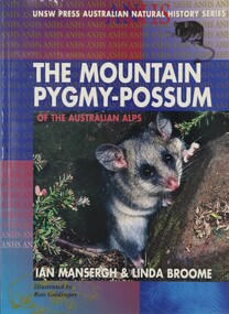
Book - The Mountain Pygmy Possum of the Australian Alps, Ian Mansergh & Linda Broome, 1994
The Mountain Pygmy possum or Burramys was known only from fossils until 1966, when the first living specimen was found hiding among fire wood at the University Ski Lodge on Mt Higginbotham, Victoria. The story of this species is a case study in conservation and ecology. Coming back from extinction, this tiny species is the only mammal restricted to the Australian Alps. It is found in Kosciusko National Park (NSW), and between Mt Bogong, Mt Higginbotham and at Mt Buller in Victoria. After years of patient research, the authors describe in this book everything that is known about the Burramys, from its physiology, mating habits and behaviour to how we can best manage and protect its habitat from human activities in the ski fields.A volume of 114 pages including 4 pages of coloured plates, maps and Illustrations by Katrina Sandiford. It was aimed at secondary students studying the geography of Alpine regions.non-fictionThe Mountain Pygmy possum or Burramys was known only from fossils until 1966, when the first living specimen was found hiding among fire wood at the University Ski Lodge on Mt Higginbotham, Victoria. The story of this species is a case study in conservation and ecology. Coming back from extinction, this tiny species is the only mammal restricted to the Australian Alps. It is found in Kosciusko National Park (NSW), and between Mt Bogong, Mt Higginbotham and at Mt Buller in Victoria. After years of patient research, the authors describe in this book everything that is known about the Burramys, from its physiology, mating habits and behaviour to how we can best manage and protect its habitat from human activities in the ski fields.environment victoria, australian endangered species, mountain pygmy possum