Showing 160 items
matching timber reserve
-
 Marysville & District Historical Society
Booklet (item) - Information booklet, Artworkz Tourism, Cora Lynn Falls, Unknown
An information booklet that was produced as a guide to the Cora Lynn Falls near Marysville in Victoria.An information booklet that was produced as a guide to the Cora Lynn Falls near Marysville in Victoria. These falls are located on the Marysville-Wood's Point Road. Cambarville is notable for its giant mountain ash (Eucalyptus regnans) trees within the Cumberland Memorial Scenic Reserve, and relics from former sawmills and gold mining. The Big Culvert is located nearby on the Marysville - Woods Point Road, which was historically part of the Yarra Track. Cambarville was established as a timber mill town in the 1940s. Timber mill owners A Cameron and FJ Barton named Cambarville. They established the mill to salvage timber from trees destroyed in the 1939 bushfires. Cambarville was impacted by the 2009 Black Saturday bushfires and any remaining structures were destroyed.marysville, victoria, photograph, cora lynn falls, waterfalls, cambarville, marysville-wood's point road, eucalyptus regnans, cumberland memorial scenic reserve, mining, big culvert, yarra track, a cameron, fj barton, 1939 bushfires, 2009 black saturday bushfires, timber mills -
Marysville & District Historical Society
Flyer (item) - Information flyer, Artworkz Tourism, Marysville-Cumberland Waterfall, Unknown
... regnans cumberland memorial scenic reserve mining timber milling ...A flyer that was produced as a guide to the Cumberland Falls near Marysville in Victoria.A flyer that was produced as a guide to the Cumberland Falls near Marysville in Victoria. These falls are located on the Marysville-Wood's Point Road. Cambarville is notable for its giant mountain ash (Eucalyptus regnans) trees within the Cumberland Memorial Scenic Reserve, and relics from former sawmills and gold mining. The Big Culvert is located nearby on the Marysville - Woods Point Road, which was historically part of the Yarra Track. Cambarville was established as a timber mill town in the 1940s. Timber mill owners A Cameron and FJ Barton named Cambarville. They established the mill to salvage timber from trees destroyed in the 1939 bushfires. Cambarville was impacted by the 2009 Black Saturday bushfires and any remaining structures were destroyed.marysville, victoria, photograph, waterfalls, cumberland falls, p. 2328, rose series postcard, souvenir, rose stereograph company, cambarville, marysville-wood's point road, mountain ash, eucalyptus regnans, cumberland memorial scenic reserve, mining, timber milling, big culvert, a cameron, fj barton, black saturday bushfires -
Marysville & District Historical Society
Booklet (item) - Information Booklet, Artworkz Tourism, Cumberland Falls, Unknown
... reserve mining timber milling big culvert a cameron fj barton ...An information booklet that was produced as a guide to the Cumberland Falls near Marysville in Victoria.An information booklet that was produced as a guide to the Cumberland Falls near Marysville in Victoria. These falls are located on the Marysville-Wood's Point Road. Cambarville is notable for its giant mountain ash (Eucalyptus regnans) trees within the Cumberland Memorial Scenic Reserve, and relics from former sawmills and gold mining. The Big Culvert is located nearby on the Marysville - Woods Point Road, which was historically part of the Yarra Track. Cambarville was established as a timber mill town in the 1940s. Timber mill owners A Cameron and FJ Barton named Cambarville. They established the mill to salvage timber from trees destroyed in the 1939 bushfires. Cambarville was impacted by the 2009 Black Saturday bushfires and any remaining structures were destroyed.marysville, victoria, photograph, waterfalls, cumberland falls, p. 2328, rose series postcard, souvenir, rose stereograph company, cambarville, marysville-wood's point road, mountain ash, eucalyptus regnans, cumberland memorial scenic reserve, mining, timber milling, big culvert, a cameron, fj barton, black saturday bushfires -
 Marysville & District Historical Society
Photograph (Item) - Black and white photograph, Bridge Over The Cumberland, c1900
An early black and white photograph of a bridge over the Cumberland Creek near Marysville in Victoria.An early black and white photograph of a bridge over the Cumberland Creek near Marysville in Victoria. The Cumberland Creek is in the Cumberland Valley near Cambarville which was a timber town near Marysville. Cambarville is notable for its giant mountain ash (Eucalyptus regnans) trees within the Cumberland Memorial Scenic Reserve, and relics from former sawmills and gold mining. The Big Culvert is located nearby on the Marysville - Woods Point Road, which was historically part of the Yarra Track. Cambarville was established as a timber mill town in the 1940s. Timber mill owners A Cameron and FJ Barton named Cambarville. They established the mill to salvage timber from trees destroyed in the 1939 bushfires. Cambarville was impacted by the 2009 Black Saturday bushfires and any remaining structures were destroyed.ARMSTRONG COLLECTION 42 STATION STREET/ SANDRINGHAM 3191/ TEL. (03) 9521 5442/ IAN M.L. ARMSTRONG OAMcumberland creek, marysville, victoria, cumberland valley, cambarville, mountain ash, eucalyptus regnans, cumberland memorial reserve, the big culvert, marysville-wood's point road, yarra track, a cameron, fj barton, 2009 black saturday bushfires -
 Marysville & District Historical Society
Photograph (Item) - Black and white photograph, Way to Cumberland Falls, c1900
An early black and white photograph of the forest near the Cumberland Falls in Victoria.An early black and white photograph of the forest near the Cumberland Falls in Victoria. The falls are located on the Marysville-Wood's Point Road. Cambarville is notable for its giant mountain ash (Eucalyptus regnans) trees within the Cumberland Memorial Scenic Reserve, and relics from former sawmills and gold mining. The Big Culvert is located nearby on the Marysville - Woods Point Road, which was historically part of the Yarra Track. Cambarville was established as a timber mill town in the 1940s. Timber mill owners A Cameron and FJ Barton named Cambarville. They established the mill to salvage timber from trees destroyed in the 1939 bushfires. Cambarville was impacted by the 2009 Black Saturday bushfires and any remaining structures were destroyed.ARMSTRONG COLLECTION 42 STATION STREET/ SANDRINGHAM 3191/ TEL. (03) 9521 5442/ IAN M.L. ARMSTRONG OAMcumberland falls, cambarville, marysville, victoria, waterfalls, postcard, souvenir, mountain ash, mining, timber mills, big culvert, yarra track, a cameron, fj barton, black saturday bushfires, 1939 bushfires, eucalyptus regnans -
 Marysville & District Historical Society
Photograph (Item) - Black and white photograph, Cumberland Falls, c1900
An early black and white photograph of Cumberland Falls near Marysville in Victoria.An early black and white photograph of Cumberland Falls near Marysville in Victoria. These falls are located on the Marysville-Wood's Point Road. Cambarville is notable for its giant mountain ash (Eucalyptus regnans) trees within the Cumberland Memorial Scenic Reserve, and relics from former sawmills and gold mining. The Big Culvert is located nearby on the Marysville - Woods Point Road, which was historically part of the Yarra Track. Cambarville was established as a timber mill town in the 1940s. Timber mill owners A Cameron and FJ Barton named Cambarville. They established the mill to salvage timber from trees destroyed in the 1939 bushfires. Cambarville was impacted by the 2009 Black Saturday bushfires and any remaining structures were destroyed.ARMSTRONG COLLECTION 42 STATION STREET/ SANDRINGHAM 3191/ TEL. (03) 9521 5442/ IAN M.L. ARMSTRONG OAMcumberland falls, cambarville, marysville, victoria, waterfalls, postcard, souvenir, mountain ash, mining, timber mills, big culvert, yarra track, a cameron, fj barton, black saturday bushfires, 1939 bushfires, eucalyptus regnans -
 Eltham District Historical Society Inc
Photograph, Peter Bassett-Smith, Upper Yarra Dam, Spring Tour, 22 Oct 1995, 22/10/1995
EXPLORING THE UPPER YARRA (Newsletter No. 105, November 1995, by Bettina Woodburn) We enjoyed the Spring Excursion, this year "Exploring the Upper Yarra" - in spite of the constant rain and the countryside under the cloud cover, especially in the valleys, being mainly shiny shades of green. The occasional fields of buttercups, clumps of arum lilies and splendid rhododendron and other flowering bushes became very special. The Cobb and Co coach was warm and a cosy retreat as we zig-zagged on the highways and byways to glimpse the Yarra River, upstream and down, its secret places, and particularly the many bridges. Russell excelled as 'Poet Laureate', reading from Dacre Smyth's book. This 1979 publication includes paintings of all the bridges along the river with poems and brief descriptions of each one. Some of the bridges are in out of the way places and are not very well known. We looked forward to hearing the poetry as much as seeing the ' constructions'…Big Pat (was he short or tall, lean or fat? He did win the two hundred pound reward for discovering gold and had the creek named after him), about the 'Eddies'?, and the disliked 'meccano' bridge in Warburton, etc. etc. The hot roast lunch in the old Reefton Hotel was also most welcome. It was easy to imagine it peopled by miners and early settlers. Starting by crossing the new (1974) concrete bridge at Warrandyte we headed through Wonga Park with views to the Christmas Hills and to the escarpment of the Yering Gorge, which causes flood waters to back up through the Yarra Glen plain, so avoiding disasters downstream. At the end of a long driveway we found the wooden, privately owned Henley Bridge (1935 after the 1934 floods). This facilitates access to different parts of Henley Farm and to Lilydale. Everard Park, named after Blanche Shallard's father, a State Member for 17 years, below the Highway Yarra crossing was in need of care. It is 10 miles from Yarra Glen by road but, as "Yarra Marra” canoeists well know, 32 winding miles down by water. After more delightful countryside scenes we joined the Warburton Highway at Woori Yallock. From the old Railway Station at Launching Place the Centennial Trail for walkers, cyclists and ' horse riders has replaced the rails. The line from Lilydale was opened in 1901, and the last diesel freight train ran to Warburton in 1965. It continued to rain as we had morning tea in Warburton in a shelter between footbridges. From here we continued upstream past the Bridge to O'Shannasy Lodge and Reservoir, Starvation Creek, and the Peninsular tunnel (miners dug it as at Pound Bend) which we visited (scrambling down those steps!) on our return after lunch. Our furthermost point was the Upper Yarra Dam Reserve (and vast catchment area). Finished in 1957 after ten years work and 100 years after Yan Yean, it supplies much of Melbourne's water. After crossing the 30m Launching Place Bridge to the Eltham side of the Yarra and Healesville, we saw in the distance the Yarra Glen Timber Trestle Bridge over the river flats "the longest for years in the land it was said!" Harry's dream of "better weather over the Divide" unfortunately didn't come true, but I'm sure we 36 members will retain happy memories of a day that was wet and green and filled with Bridges. Bettina Woodburn - October 1995 Record of the Society's history of activities - Spring 1995 excursionColour photographactivities, upper yarra dam, 1995, peter bassett-smith -
 Eltham District Historical Society Inc
Photograph, Peter Bassett-Smith, Upper Yarra Dam, Spring Tour, 22 Oct 1995, 22/10/1995
EXPLORING THE UPPER YARRA (Newsletter No. 105, November 1995, by Bettina Woodburn) We enjoyed the Spring Excursion, this year "Exploring the Upper Yarra" - in spite of the constant rain and the countryside under the cloud cover, especially in the valleys, being mainly shiny shades of green. The occasional fields of buttercups, clumps of arum lilies and splendid rhododendron and other flowering bushes became very special. The Cobb and Co coach was warm and a cosy retreat as we zig-zagged on the highways and byways to glimpse the Yarra River, upstream and down, its secret places, and particularly the many bridges. Russell excelled as 'Poet Laureate', reading from Dacre Smyth's book. This 1979 publication includes paintings of all the bridges along the river with poems and brief descriptions of each one. Some of the bridges are in out of the way places and are not very well known. We looked forward to hearing the poetry as much as seeing the ' constructions'…Big Pat (was he short or tall, lean or fat? He did win the two hundred pound reward for discovering gold and had the creek named after him), about the 'Eddies'?, and the disliked 'meccano' bridge in Warburton, etc. etc. The hot roast lunch in the old Reefton Hotel was also most welcome. It was easy to imagine it peopled by miners and early settlers. Starting by crossing the new (1974) concrete bridge at Warrandyte we headed through Wonga Park with views to the Christmas Hills and to the escarpment of the Yering Gorge, which causes flood waters to back up through the Yarra Glen plain, so avoiding disasters downstream. At the end of a long driveway we found the wooden, privately owned Henley Bridge (1935 after the 1934 floods). This facilitates access to different parts of Henley Farm and to Lilydale. Everard Park, named after Blanche Shallard's father, a State Member for 17 years, below the Highway Yarra crossing was in need of care. It is 10 miles from Yarra Glen by road but, as "Yarra Marra” canoeists well know, 32 winding miles down by water. After more delightful countryside scenes we joined the Warburton Highway at Woori Yallock. From the old Railway Station at Launching Place the Centennial Trail for walkers, cyclists and ' horse riders has replaced the rails. The line from Lilydale was opened in 1901, and the last diesel freight train ran to Warburton in 1965. It continued to rain as we had morning tea in Warburton in a shelter between footbridges. From here we continued upstream past the Bridge to O'Shannasy Lodge and Reservoir, Starvation Creek, and the Peninsular tunnel (miners dug it as at Pound Bend) which we visited (scrambling down those steps!) on our return after lunch. Our furthermost point was the Upper Yarra Dam Reserve (and vast catchment area). Finished in 1957 after ten years work and 100 years after Yan Yean, it supplies much of Melbourne's water. After crossing the 30m Launching Place Bridge to the Eltham side of the Yarra and Healesville, we saw in the distance the Yarra Glen Timber Trestle Bridge over the river flats "the longest for years in the land it was said!" Harry's dream of "better weather over the Divide" unfortunately didn't come true, but I'm sure we 36 members will retain happy memories of a day that was wet and green and filled with Bridges. Bettina Woodburn - October 1995 Record of the Society's history of activities - Spring 1995 excursionColour photographactivities, upper yarra dam, 1995 -
 Glen Eira Historical Society
Album - Album page, Normanby Road, Circa 1972
This photograph is part of the Caulfield Historical Album 1972. This album was created in approximately 1972 as part of a project by the Caulfield Historical Society to assist in identifying buildings worthy of preservation. The album is related to a Survey the Caulfield Historical Society developed in collaboration with the National Trust of Australia (Victoria) and Caulfield City Council to identify historic buildings within the City of Caulfield that warranted the protection of a National Trust Classification. Principal photographer thought to be Trevor Hart, member of Caulfield Historical Society. Most photographs were taken between 1966-1972 with a small number of photographs being older and from unknown sources. All photographs are black and white except where stated, with 386 photographs over 198 pages. From: Glen Eira Heritage Management Plan (1996) - Vol 2 by Andrew Ward and Associates The widening of Dandenong Road during the late 1980's has resulted in the destruction of the houses in the path of the roadworks and the construction of a high fence serving as a visual barrier between that thoroughfare and the remaining houses. Where comparatively large villas once stood on spacious allotments, only "Wisteria" survives at No. 135 Normanby Road. Adopting forms and timber enrichment characteristic of the American Queen Anne style, it has this in common with the largely reconstructed timber villa at no. 11 Normanby Avenue and to a lesser extent, 746 Inkerman Road. Normanby Road retains its comparatively opulent Edwardian character in a mature landscaped setting with spacious gardens and mature planes parallel with the railway reserve which, on account of the low lying ground in its vicinity has a high embankment commencing on the alignment of Malvern Grove and continuing to Caulfield Station. The earliest villas are Edwardian. Page 148 of Photograph Album with one landscape photograph of a house on Normanby Road (not Street).Handwritten: Normanby St [top right] / 148 [bottom right]trevor hart, verandah, porch, bull nosed verandah, tower house, tower, stone fence, normanby road, wisteria, american queen anne style, queen anne style, 1890's, mayfield grove, normanby street, timber houses, caulfield north, house names, edwardian, edwardian style, gardens -
Glen Eira Historical Society
Letter - HUNT, WILLIAM HOGARTH
Two sets of this man's handwritten memories: 1/Five pages of handwritten personal memories, written by William Hogarth Hunt 13/07/1977. He outlines his family, their travels and settlement in 1908 at Glenhuntly: a detailed account of residents, shop owners, land sales and identities, Murray Ross, Mr Burr of Burr’s Gun Oil and Mr Zarman. Also details Glenhuntly Methodist Church, football, athletics, Glenhuntly Aerodrome and an extensive list of local residents and their stories. 2/Two pages of handwritten personal memories, written by William Hogarth Hunt 02/09/1977. A detailed account of residents, shop owners, identities, athletes, local policemen and their stories in the Glen Huntly area.personal memories, hunt william hogarth, glenhuntly, grange road, trams, plumber, stone mary ann, neerim road, wanalta road, schurme mrs, private hospital, hospitals, watson grove, hunt jessie, hunt alfred, hunt charles, smith mr, fisher mr, smith mrs, jockeys, dore george, ‘willis’, builders, house names, mernda, roseberry grove, el nido, neerim road, glenhuntly post office, mrs fielder’s sweetshop, mrs beer’s sweet shop, paddocks, confectionery, fielder fred, maroona road, murrumbeena, grocers, callister dave, carnegie state school, hay and corn store, james street, woodyard, hillards chemist, hughes body works, chemists, davidson’s, glenhuntly printing, hay and corn stores, railway gates, anz bank, fox mr, martin jack, fox mrs, clothing stores, steam rollers, radio and tv shop, beasley j, delicatessen/ham and beef shop, butchers, schurme’s private hospital, gellatley george, tailors, commonwealth banks, watson grove, banks, preston peter, e.j. & h. amos, hardware stores, estate agents, glenhuntly picture theatre, whittle mr, theatres, newsagency, cooper and cooke, station street, f.j. long and co, jennings a.v, timber yards, builders, ‘the estate’, hillcrest estate, grange road, marara road, rosedale avenue, hobart jack, mackie road, confectionery stores, ross murray, glenhuntly athletic club, godfrey evelyn, athletics clubs, railways, glenhuntly junior football club, elsternwick, princess park, carnegie oval, booran road, koornang park, ormond oval – ee. gunn reserve, glenhuntly oval, oakleigh road, victorian amateur turf club, koornang road, glenhuntly aerodrome, neville street, glenhuntly state school, rosslyn street, geary mr, lauriston tennis courts, bakers, carnegie r.s.l., east bentleigh, bowling clubs, tucker road, tennis clubs, centre road, murrumbeena road, larman mr, hollway street, nurseries, parker street, lyle marshall, burr mr, solicitors, builders, bones nursery, ‘burr’s gunoil’, glenhuntly methodist church, carnegie, smith alf, ezard family, clemens family, noy family, noy clarrie, dickie family, storey family, storey george, davis family, joss house, chinese community, wattle avenue, grange road, glenhuntly amateur football club, football clubs, glenhuntly athletic club, athletic clubs, glen huntly junior football club, carnegie oval, koornang park, glenhuntly oval, victorian amateur turf club, glenhuntly aerodome, glenhuntly state school, geary mr., bakers, east bentleigh, tucker road, centre road, larman mr, nurseries, lyle marshall, solicitors, bones nursery, carnegie, "the estate", royal avenue, mckay avenue, dumsday bertha miss, love family, gilmour family, waratah ave, sinclair mr, tuckpointers, bricks, donegan mr, plumbers, frazer mr, frazer and jenkinson printers, frazer arthur, ezard manufacturing, jewellers, private hospital, maroona road, o'carroll mr, beattie mr, horse trainer, morton tom, lord harry, estate agents, ormond, councillors, taylor mr, builders, gibson family, westley alf, o'carroll j (jack) d, glenhuntly athletics club, athletes, jack page's bakery and cake shop, nay clarrie, hunt william h., hunt alf, page jack, armstrong jack, manchester grove, morgan advertising, cusdin sid, farrier, glenhuntly cricket club, caulfield racecourse, neerim road, hoffman's plumbing, emma street, st. agnes school, st. agnes church hall, jenkin 'boss' mr, teachers, hawthorn miss, quinn miss, chitty charlie, chitty's timber, crystal palace picture theatre, theatres, marsh bill, hardware shops, watson arthur w, j.s. kidd and company, marshes hardware, kidd's hardware, bruce ivy, 'belgrave', house names, belgrave road, dandenong road, hunter 'pud', police officers, hunt jess, kangaroo road, murrumbeena, glen huntly -
 Glen Eira Historical Society
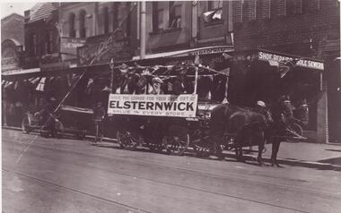
Photograph - ELSTERNWICK
This file contains 15 items: 1/5 Photocopied photographs of early Elsternwick buildings and railway reserve c. 1901. 2/2 Photocopied photos and one original photo of local transport in Elsternwick c. 1908, and one print of Nettie Palmer on a bicycle in Elsternwick in 1902. 3/7 coloured photographs of painted signage on buildings in Elsternwick uncovered in 1989.elsternwick, forests, timber, elsternwick post office, elsternwick railway reserve, hampton albert g., motorcars, motorvehicle repair shops, taxis, beavis street, davenport ron, carre street, wagons, johnson mr., grocers, signs, higgins james, tarrier, blacksmith, palmer nettie, bicycles -
 Bendigo Historical Society Inc.
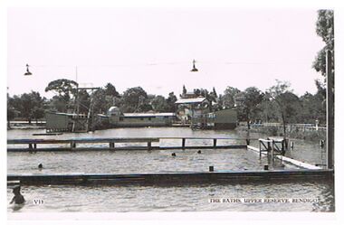
Postcard - THE BATHS, UPPER RESERVE, BENDIGO
Black and white postcard, showing Baths in Upper Reserve, Bendigo. Image shows three separate pools, divided with timber walkways. In background, bathing sheds, lights suspended over pools. On back of card ' Valentine's Post Card , genuine photograph'Valentine's Post Cardbendigo, hospital, bendigo, baths, upper reserve, pool, sport, swimming -
 Bendigo Historical Society Inc.
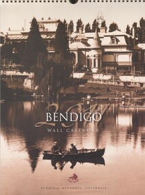
Ephemera - BENDIGO WALL CALENDAR 2011
A 2011 Bendigo wall calendar. Photos included: J.R. Hoskins timber yard, Dudley House,Bendigo tram, Bendigo advertiser hargreaves Street, Commercial House, Chinese Joss House, Victoria Hill,Members of the Bendigo stock exchange, Upper reserve View Street, Hotel Shamrock, Scholten & Marsh, Bendigo arcadebendigo, tourism, calendar -
 Rutherglen Historical Society
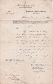
Document - License to thin trees, 1899 (Exact)
Dated July 14th 1899. Sent to Mr W. Cooper / c/o Mr Barrie / Storekeeper / No. 2 Valley / Chiltern / "Copy of Land Act 1896 / Regulations. Chapter XI Thinning Licenses"Document on stiff paper. Letter to Mr W. Cooper granting license to thin trees on a block of land at Chiltern Reserve. On back, copy of Land Act Regulations 1890"Department of Lands and Survey. On Forest Business"license, timber felling, cooper family, forestry, chiltern reserve -
 Ballarat Heritage Services
Photograph - Digital photographs, L.J. Gervasoni, Boroondara General Cemetery Gatehouse, c2005-2015
The Boroondara General Cemetery is registerd by Heritage VictoriaBoroondara Cemetery in kew was established in 1858. It has an unusual triangular reserve bounded by High Street, Park Hill Road and Victoria Park, Kew. The caretaker's lodge and administrative office (1860 designed by Charles Vickers, additions, 1866-1899 by Albert Purchas) form a picturesque two-storey brick structure with a slate roof and clock tower. A rotunda or shelter (1890, Albert Purchas) is located in the centre of the cemetery: this has an octagonal hipped roof with fish scale slates and a decorative brick base with a tessellated floor and timber seating. The cemetery is surrounded by a 2.7 metre high ornamental red brick wall (1895-96, Albert Purchas) with some sections of vertical iron palisades between brick pillars. Albert Purchas was a prominent Melbourne architect who was the Secretary of the Melbourne General Cemetery from 1852 to 1907 and Chairman of the Boroondara Cemetery Board of Trustees from 1867 to 1909. He made a significant contribution to the design of the Boroondara Cemetery Boroondara Cemetery is an outstanding example of the Victorian Garden Cemetery movement in Victoria, retaining key elements of the style, despite overdevelopment which has obscured some of the paths and driveways. Elements of the style represented at Boroondara include an ornamental boundary fence, a system of curving paths which are kerbed and follow the site's natural contours, defined views, recreational facilities such as the rotunda, a landscaped park like setting, sectarian divisions for burials, impressive monuments, wrought and cast iron grave surrounds and exotic symbolic plantings. In the 1850s cemeteries were located on the periphery of populated areas because of concerns about diseases like cholera. They were designed to be attractive places for mourners and visitors to walk and contemplate. Typically cemeteries were arranged to keep religions separated and this tended to maintain links to places of origin, reflecting a migrant society. Other developments included cast iron entrance gates, built in 1889 to a design by Albert Purchas; a cemetery shelter or rotunda, built in 1890, which is a replica of one constructed in the Melbourne General Cemetery in the same year; an ornamental brick fence erected in 1896-99(?); the construction and operation of a terminus for a horse tram at the cemetery gates during 1887-1915; and the Springthorpe Memorial built between 1897 and 1907. A brick cremation wall and a memorial rose garden were constructed near the entrance in the mid- twentieth century(c.1955-57) and a mausoleum completed in 2001.The maintenance shed/depot close to High Street was constructed in 1987. The original entrance was altered in 2000 and the original cast iron gates moved to the eastern entrance of the Mausoleum. Some notable memorials include The Springthorpe Memorial (VHR 522), The Syme Memorial (1908), The Cussen Memorial (VHR 2036). Burials within the cemetery include the Henty family, artists Louis Buvelot and Charles Nuttall, businessmen John Halfey and publisher David Syme, artist and diarist Georgiana McCrae, actress Nellie Stewart and architect and designer of the Boroondara and Melbourne General Cemeteries, Albert Purchas. The Boroondara Cemetery features many plants, mostly conifers and shrubs of funerary symbolism, which line the boundaries, road and pathways, and frame the cemetery monuments or are planted on graves. The major plantings include an impressive row of Bhutan Cypress (Cupressus torulosa), interplanted with Sweet Pittosporum (Pittosporum undulatum), and a few Pittosporum crassifolium, along the High Street and Parkhill Street, where the planting is dominated by Sweet Pittosporum. Planting within the cemetery includes rows and specimen trees of Bhutan Cypress and Italian Cypress (Cupressus sempervirens), including a row with alternate plantings of both species. The planting includes an unusual "squat" form of an Italian Cypress. More of these trees probably lined the cemetery roads and paths. Also dominating the cemetery landscape near the Rotunda is a stand of 3 Canary Island Pines (Pinus canariensis), a Bunya Bunya Pine (Araucaria bidwillii) and a Weeping Elm (Ulmus glabra 'Camperdownii'). Amongst the planting are the following notable conifers: a towering Bunya Bunya Pine (Araucaria bidwillii), a Coast Redwood (Sequoia sempervirens), a rare Golden Funeral Cypress (Chamaecyparis funebris 'Aurea'), two large Funeral Cypress (Chamaecyparis funebris), and the only known Queensland Kauri (Agathis robusta) in a cemetery in Victoria. The Cemetery records, including historical plans of the cemetery from 1859, are held by the administration and their retention enhances the historical significance of the Cemetery. Digital images of a red brick gatehouse at Boroondara General Cemetery in Kew.cemetery, boroondara, kew, gatehouse, clock, tower, clocktower, heritage, memorial -
 Ballarat Heritage Services
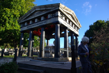
Photograph - Digital photographs, L.J. Gervasoni, Boroondara General Cemetery Springthorpe Memorial, c2005-2015
The Boroondara General Cemetery is registerd by Heritage VictoriaFrom Heritage Victoria Statement of Significance Last updated on - December 15, 2005 What is significant? Boroondara Cemetery, established in 1858, is within an unusual triangular reserve bounded by High Street, Park Hill Road and Victoria Park, Kew. The caretaker's lodge and administrative office (1860 designed by Charles Vickers, additions, 1866-1899 by Albert Purchas) form a picturesque two-storey brick structure with a slate roof and clock tower. A rotunda or shelter (1890, Albert Purchas) is located in the centre of the cemetery: this has an octagonal hipped roof with fish scale slates and a decorative brick base with a tessellated floor and timber seating. The cemetery is surrounded by a 2.7 metre high ornamental red brick wall (1895-96, Albert Purchas) with some sections of vertical iron palisades between brick pillars. Albert Purchas was a prominent Melbourne architect who was the Secretary of the Melbourne General Cemetery from 1852 to 1907 and Chairman of the Boroondara Cemetery Board of Trustees from 1867 to 1909. He made a significant contribution to the design of the Boroondara Cemetery Boroondara Cemetery is an outstanding example of the Victorian Garden Cemetery movement in Victoria, retaining key elements of the style, despite overdevelopment which has obscured some of the paths and driveways. Elements of the style represented at Boroondara include an ornamental boundary fence, a system of curving paths which are kerbed and follow the site's natural contours, defined views, recreational facilities such as the rotunda, a landscaped park like setting, sectarian divisions for burials, impressive monuments, wrought and cast iron grave surrounds and exotic symbolic plantings. In the 1850s cemeteries were located on the periphery of populated areas because of concerns about diseases like cholera. They were designed to be attractive places for mourners and visitors to walk and contemplate. Typically cemeteries were arranged to keep religions separated and this tended to maintain links to places of origin, reflecting a migrant society. Other developments included cast iron entrance gates, built in 1889 to a design by Albert Purchas; a cemetery shelter or rotunda, built in 1890, which is a replica of one constructed in the Melbourne General Cemetery in the same year; an ornamental brick fence erected in 1896-99(?); the construction and operation of a terminus for a horse tram at the cemetery gates during 1887-1915; and the Springthorpe Memorial built between 1897 and 1907. A brick cremation wall and a memorial rose garden were constructed near the entrance in the mid- twentieth century(c.1955-57) and a mausoleum completed in 2001.The maintenance shed/depot close to High Street was constructed in 1987. The original entrance was altered in 2000 and the original cast iron gates moved to the eastern entrance of the Mausoleum. The Springthorpe Memorial (VHR 522) set at the entrance to the burial ground commemorates Annie Springthorpe, and was erected between 1897 and 1907 by her husband Dr John Springthorpe. It was the work of the sculptor Bertram Mackennal, architect Harold Desbrowe Annear, landscape designer and Director of the Melbourne Bortanic Gardens, W.R. Guilfoyle, with considerable input from Dr Springthorpe The memorial is in the form of a small temple in a primitive Doric style. It was designed by Harold Desbrowe Annear and includes Bertram Mackennal sculptures in Carrara marble. Twelve columns of deep green granite from Scotland support a Harcourt granite superstructure. The roof by Brooks Robinson is a coloured glass dome, which sits within the rectangular form and behind the pediments. The sculptural group raised on a dais, consists of the deceased woman lying on a sarcophagus with an attending angel and mourner. The figure of Grief crouches at the foot of the bier and an angel places a wreath over Annie's head, symbolising the triumph of immortal life over death. The body of the deceased was placed in a vault below. The bronze work is by Marriots of Melbourne. Professor Tucker of the University of Melbourne composed appropriate inscriptions in English and archaic Greek lettering.. The floor is a geometric mosaic and the glass dome roof is of Tiffany style lead lighting in hues of reds and pinks in a radiating pattern. The memorial originally stood in a landscape triangular garden of about one acre near the entrance to the cemetery. However, after Dr Springthorpe's death in 1933 it was found that transactions for the land had not been fully completed so most of it was regained by the cemetery. A sundial and seat remain. The building is almost completely intact. The only alteration has been the removal of a glass canopy over the statuary and missing chains between posts. The Argus (26 March 1933) considered the memorial to be the most beautiful work of its kind in Australia. No comparable buildings are known. The Syme Memorial (1908) is a memorial to David Syme, political economist and publisher of the Melbourne Age newspaper. The Egyptian memorial designed by architect Arthur Peck is one of the most finely designed and executed pieces of monumental design in Melbourne. It has a temple like form with each column having a different capital detail. These support a cornice that curves both inwards and outwards. The tomb also has balustradings set between granite piers which create porch spaces leading to the entrance ways. Two variegated Port Jackson Figs are planted at either end. The Cussen Memorial (VHR 2036) was constructed in 1912-13 by Sir Leo Cussen in memory of his young son Hubert. Sir Leo Finn Bernard Cussen (1859-1933), judge and member of the Victorian Supreme Court in 1906. was buried here. The family memorial is one of the larger and more impressive memorials in the cemetery and is an interesting example of the 1930s Gothic Revival style architecture. It takes the form of a small chapel with carvings, diamond shaped roof tiles and decorated ridge embellishing the exterior. By the 1890s, the Boroondara Cemetery was a popular destination for visitors and locals admiring the beauty of the grounds and the splendid monuments. The edge of suburban settlement had reached the cemetery in the previous decade. Its Victorian garden design with sweeping curved drives, hill top views and high maintenance made it attractive. In its Victorian Garden Cemetery design, Boroondara was following an international trend. The picturesque Romanticism of the Pere la Chaise garden cemetery established in Paris in 1804 provided a prototype for great metropolitan cemeteries such as Kensal Green (1883) and Highgate (1839) in London and the Glasgow Necropolis (1831). Boroondara Cemetery was important in establishing this trend in Australia. The cemetery's beauty peaked with the progressive completion of the spectacular Springthorpe Memorial between 1899 and 1907. From about the turn of the century, the trustees encroached on the original design, having repeatedly failed in attempts to gain more land. The wide plantations around road boundaries, grassy verges around clusters of graves in each denomination, and most of the landscaped surround to the Springthorpe memorial are now gone. Some of the original road and path space were resumed for burial purposes. The post war period saw an increased use of the Cemetery by newer migrant groups. The mid- to late- twentieth century monuments were often placed on the grassed edges of the various sections and encroached on the roadways as the cemetery had reached the potential foreseen by its design. These were well tended in comparison with Victorian monuments which have generally been left to fall into a state of neglect. The Boroondara Cemetery features many plants, mostly conifers and shrubs of funerary symbolism, which line the boundaries, road and pathways, and frame the cemetery monuments or are planted on graves. The major plantings include an impressive row of Bhutan Cypress (Cupressus torulosa), interplanted with Sweet Pittosporum (Pittosporum undulatum), and a few Pittosporum crassifolium, along the High Street and Parkhill Street, where the planting is dominated by Sweet Pittosporum. Planting within the cemetery includes rows and specimen trees of Bhutan Cypress and Italian Cypress (Cupressus sempervirens), including a row with alternate plantings of both species. The planting includes an unusual "squat" form of an Italian Cypress. More of these trees probably lined the cemetery roads and paths. Also dominating the cemetery landscape near the Rotunda is a stand of 3 Canary Island Pines (Pinus canariensis), a Bunya Bunya Pine (Araucaria bidwillii) and a Weeping Elm (Ulmus glabra 'Camperdownii') Amongst the planting are the following notable conifers: a towering Bunya Bunya Pine (Araucaria bidwillii), a Coast Redwood (Sequoia sempervirens), a rare Golden Funeral Cypress (Chamaecyparis funebris 'Aurea'), two large Funeral Cypress (Chamaecyparis funebris), and the only known Queensland Kauri (Agathis robusta) in a cemetery in Victoria. The Cemetery records, including historical plans of the cemetery from 1859, are held by the administration and their retention enhances the historical significance of the Cemetery. How is it significant? Boroondara Cemetery is of aesthetic, architectural, scientific (botanical) and historical significance to the State of Victoria. Why is it significant? The Boroondara Cemetery is of historical and aesthetic significance as an outstanding example of a Victorian garden cemetery. The Boroondara Cemetery is of historical significance as a record of Victorian life from the 1850s, and the early settlement of Kew. It is also significant for its ability to demonstrate, through the design and location of the cemetery, attitudes towards burial, health concerns and the importance placed on religion, at the time of its establishment. The Boroondara Cemetery is of architectural significance for the design of the gatehouse or sexton's lodge and cemetery office (built in stages from 1860 to 1899), the ornamental brick perimeter fence and elegant cemetery shelter to the design of prominent Melbourne architects, Charles Vickers (for the original 1860 cottage) and Albert Purchas, cemetery architect and secretary from 1864 to his death in 1907. The Boroondara Cemetery has considerable aesthetic significance which is principally derived from its tranquil, picturesque setting; its impressive memorials and monuments; its landmark features such as the prominent clocktower of the sexton's lodge and office, the mature exotic plantings, the decorative brick fence and the entrance gates; its defined views; and its curving paths. The Springthorpe Memorial (VHR 522), the Syme Memorial and the Cussen Memorial (VHR 2036), all contained within the Boroondara Cemetery, are of aesthetic and architectural significance for their creative and artistic achievement. The Boroondara Cemetery is of scientific (botanical) significance for its collection of rare mature exotic plantings. The Golden Funeral Cypress, (Chamaecyparis funebris 'Aurea') is the only known example in Victoria. The Boroondara Cemetery is of historical significance for the graves, monuments and epitaphs of a number of individuals whose activities have played a major part in Australia's history. They include the Henty family, artists Louis Buvelot and Charles Nuttall, businessmen John Halfey and publisher David Syme, artist and diarist Georgiana McCrae, actress Nellie Stewart and architect and designer of the Boroondara and Melbourne General Cemeteries, Albert Purchas.Digital image of the Springthorpe Memorial in the Boroondara General Cemeterycemetery, boroondara, kew, gatehouse, clock, tower, clocktower, heritage, memorial, springthorpe memorial -
 Ballarat Heritage Services
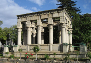
photograph - Digital photographs, L.J. Gervasoni, Syme Memorial Boroondara General Cemetery, c2010, c2005-2015
The Boroondara General Cemetery is registered by Heritage VictoriaFrom Heritage Victoria Statement of Significance Last updated on - December 15, 2005 (undated change to citation made since 2005) What is significant? Boroondara Cemetery, established in 1858, is within an unusual triangular reserve bounded by High Street, Park Hill Road and Victoria Park, Kew. The caretaker's lodge and administrative office (1860 designed by Charles Vickers, additions, 1866-1899 by Albert Purchas) form a picturesque two-storey brick structure with a slate roof and clock tower. A rotunda or shelter (1890, Albert Purchas) is located in the centre of the cemetery: this has an octagonal hipped roof with fish scale slates and a decorative brick base with a tessellated floor and timber seating. The cemetery is surrounded by a 2.7 metre high ornamental red brick wall (1895-96, Albert Purchas) with some sections of vertical iron palisades between brick pillars. Albert Purchas was a prominent Melbourne architect who was the Secretary of the Melbourne General Cemetery from 1852 to 1907 and Chairman of the Boroondara Cemetery Board of Trustees from 1867 to 1909. He made a significant contribution to the design of the Boroondara Cemetery. Boroondara Cemetery is an outstanding example of the Victorian Garden Cemetery movement in Victoria, retaining key elements of the style, despite overdevelopment which has obscured some of the paths and driveways. Elements of the style represented at Boroondara include an ornamental boundary fence, a system of curving paths which are kerbed and follow the site's natural contours, defined views, recreational facilities such as the rotunda, a landscaped park like setting, sectarian divisions for burials, impressive monuments, wrought and cast iron grave surrounds and exotic symbolic plantings. In the 1850s cemeteries were located on the periphery of populated areas because of concerns about diseases like cholera. They were designed to be attractive places for mourners and visitors to walk and contemplate. Typically cemeteries were arranged to keep religions separated and this tended to maintain links to places of origin, reflecting a migrant society. Other developments included cast iron entrance gates, built in 1889 to a design by Albert Purchas; a cemetery shelter or rotunda, built in 1890, which is a replica of one constructed in the Melbourne General Cemetery in the same year; an ornamental brick fence erected in 1896-99(?); the construction and operation of a terminus for a horse tram at the cemetery gates during 1887-1915; and the Springthorpe Memorial built between 1897 and 1907. ... ... The Syme Memorial (1908) is a memorial to David Syme, political economist and publisher of the Melbourne Age newspaper. The Egyptian memorial designed by architect Walter Richmond Butler is one of the most finely designed and executed pieces of monumental design in Melbourne. It has a temple like form with each column having a different capital detail. These support a cornice that curves both inwards and outwards. The tomb also has balustradings set between granite piers which create porch spaces leading to the entrance ways. Two variegated Port Jackson Figs are planted at either end. ... How is it significant? Boroondara Cemetery is of aesthetic, architectural, scientific (botanical) and historical significance to the State of Victoria. ... ...Digital image of the Syme memorial in Boroondara Cemetery, Kew. cemetery, boroondara, kew, gatehouse, clock, tower, clocktower, heritage, memorial -
 Ballarat Heritage Services
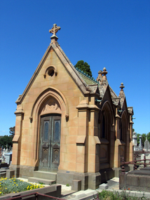
Photograph - Digital photographs, Cussen Memorial in the Boroondara General Cemetery, Kew, Victoria, c2005-2015
The Boroondara General Cemetery is registerd by Heritage VictoriaFrom Heritage Victoria Statement of Significance Last updated on - December 15, 2005 What is significant? Boroondara Cemetery, established in 1858, is within an unusual triangular reserve bounded by High Street, Park Hill Road and Victoria Park, Kew. The caretaker's lodge and administrative office (1860 designed by Charles Vickers, additions, 1866-1899 by Albert Purchas) form a picturesque two-storey brick structure with a slate roof and clock tower. A rotunda or shelter (1890, Albert Purchas) is located in the centre of the cemetery: this has an octagonal hipped roof with fish scale slates and a decorative brick base with a tessellated floor and timber seating. The cemetery is surrounded by a 2.7 metre high ornamental red brick wall (1895-96, Albert Purchas) with some sections of vertical iron palisades between brick pillars. Albert Purchas was a prominent Melbourne architect who was the Secretary of the Melbourne General Cemetery from 1852 to 1907 and Chairman of the Boroondara Cemetery Board of Trustees from 1867 to 1909. He made a significant contribution to the design of the Boroondara Cemetery Boroondara Cemetery is an outstanding example of the Victorian Garden Cemetery movement in Victoria, retaining key elements of the style, despite overdevelopment which has obscured some of the paths and driveways. Elements of the style represented at Boroondara include an ornamental boundary fence, a system of curving paths which are kerbed and follow the site's natural contours, defined views, recreational facilities such as the rotunda, a landscaped park like setting, sectarian divisions for burials, impressive monuments, wrought and cast iron grave surrounds and exotic symbolic plantings. In the 1850s cemeteries were located on the periphery of populated areas because of concerns about diseases like cholera. They were designed to be attractive places for mourners and visitors to walk and contemplate. Typically cemeteries were arranged to keep religions separated and this tended to maintain links to places of origin, reflecting a migrant society. Other developments included cast iron entrance gates, built in 1889 to a design by Albert Purchas; a cemetery shelter or rotunda, built in 1890, which is a replica of one constructed in the Melbourne General Cemetery in the same year; an ornamental brick fence erected in 1896-99(?); the construction and operation of a terminus for a horse tram at the cemetery gates during 1887-1915; and the Springthorpe Memorial built between 1897 and 1907. A brick cremation wall and a memorial rose garden were constructed near the entrance in the mid- twentieth century(c.1955-57) and a mausoleum completed in 2001.The maintenance shed/depot close to High Street was constructed in 1987. The original entrance was altered in 2000 and the original cast iron gates moved to the eastern entrance of the Mausoleum. The Springthorpe Memorial (VHR 522) set at the entrance to the burial ground commemorates Annie Springthorpe, and was erected between 1897 and 1907 by her husband Dr John Springthorpe. It was the work of the sculptor Bertram Mackennal, architect Harold Desbrowe Annear, landscape designer and Director of the Melbourne Bortanic Gardens, W.R. Guilfoyle, with considerable input from Dr Springthorpe The memorial is in the form of a small temple in a primitive Doric style. It was designed by Harold Desbrowe Annear and includes Bertram Mackennal sculptures in Carrara marble. Twelve columns of deep green granite from Scotland support a Harcourt granite superstructure. The roof by Brooks Robinson is a coloured glass dome, which sits within the rectangular form and behind the pediments. The sculptural group raised on a dais, consists of the deceased woman lying on a sarcophagus with an attending angel and mourner. The figure of Grief crouches at the foot of the bier and an angel places a wreath over Annie's head, symbolising the triumph of immortal life over death. The body of the deceased was placed in a vault below. The bronze work is by Marriots of Melbourne. Professor Tucker of the University of Melbourne composed appropriate inscriptions in English and archaic Greek lettering.. The floor is a geometric mosaic and the glass dome roof is of Tiffany style lead lighting in hues of reds and pinks in a radiating pattern. The memorial originally stood in a landscape triangular garden of about one acre near the entrance to the cemetery. However, after Dr Springthorpe's death in 1933 it was found that transactions for the land had not been fully completed so most of it was regained by the cemetery. A sundial and seat remain. The building is almost completely intact. The only alteration has been the removal of a glass canopy over the statuary and missing chains between posts. The Argus (26 March 1933) considered the memorial to be the most beautiful work of its kind in Australia. No comparable buildings are known. The Syme Memorial (1908) is a memorial to David Syme, political economist and publisher of the Melbourne Age newspaper. The Egyptian memorial designed by architect Arthur Peck is one of the most finely designed and executed pieces of monumental design in Melbourne. It has a temple like form with each column having a different capital detail. These support a cornice that curves both inwards and outwards. The tomb also has balustradings set between granite piers which create porch spaces leading to the entrance ways. Two variegated Port Jackson Figs are planted at either end. The Cussen Memorial (VHR 2036) was constructed in 1912-13 by Sir Leo Cussen in memory of his young son Hubert. Sir Leo Finn Bernard Cussen (1859-1933), judge and member of the Victorian Supreme Court in 1906. was buried here. The family memorial is one of the larger and more impressive memorials in the cemetery and is an interesting example of the 1930s Gothic Revival style architecture. It takes the form of a small chapel with carvings, diamond shaped roof tiles and decorated ridge embellishing the exterior. By the 1890s, the Boroondara Cemetery was a popular destination for visitors and locals admiring the beauty of the grounds and the splendid monuments. The edge of suburban settlement had reached the cemetery in the previous decade. Its Victorian garden design with sweeping curved drives, hill top views and high maintenance made it attractive. In its Victorian Garden Cemetery design, Boroondara was following an international trend. The picturesque Romanticism of the Pere la Chaise garden cemetery established in Paris in 1804 provided a prototype for great metropolitan cemeteries such as Kensal Green (1883) and Highgate (1839) in London and the Glasgow Necropolis (1831). Boroondara Cemetery was important in establishing this trend in Australia. The cemetery's beauty peaked with the progressive completion of the spectacular Springthorpe Memorial between 1899 and 1907. From about the turn of the century, the trustees encroached on the original design, having repeatedly failed in attempts to gain more land. The wide plantations around road boundaries, grassy verges around clusters of graves in each denomination, and most of the landscaped surround to the Springthorpe memorial are now gone. Some of the original road and path space were resumed for burial purposes. The post war period saw an increased use of the Cemetery by newer migrant groups. The mid- to late- twentieth century monuments were often placed on the grassed edges of the various sections and encroached on the roadways as the cemetery had reached the potential foreseen by its design. These were well tended in comparison with Victorian monuments which have generally been left to fall into a state of neglect. The Boroondara Cemetery features many plants, mostly conifers and shrubs of funerary symbolism, which line the boundaries, road and pathways, and frame the cemetery monuments or are planted on graves. The major plantings include an impressive row of Bhutan Cypress (Cupressus torulosa), interplanted with Sweet Pittosporum (Pittosporum undulatum), and a few Pittosporum crassifolium, along the High Street and Parkhill Street, where the planting is dominated by Sweet Pittosporum. Planting within the cemetery includes rows and specimen trees of Bhutan Cypress and Italian Cypress (Cupressus sempervirens), including a row with alternate plantings of both species. The planting includes an unusual "squat" form of an Italian Cypress. More of these trees probably lined the cemetery roads and paths. Also dominating the cemetery landscape near the Rotunda is a stand of 3 Canary Island Pines (Pinus canariensis), a Bunya Bunya Pine (Araucaria bidwillii) and a Weeping Elm (Ulmus glabra 'Camperdownii') Amongst the planting are the following notable conifers: a towering Bunya Bunya Pine (Araucaria bidwillii), a Coast Redwood (Sequoia sempervirens), a rare Golden Funeral Cypress (Chamaecyparis funebris 'Aurea'), two large Funeral Cypress (Chamaecyparis funebris), and the only known Queensland Kauri (Agathis robusta) in a cemetery in Victoria. The Cemetery records, including historical plans of the cemetery from 1859, are held by the administration and their retention enhances the historical significance of the Cemetery. How is it significant? Boroondara Cemetery is of aesthetic, architectural, scientific (botanical) and historical significance to the State of Victoria. Why is it significant? The Boroondara Cemetery is of historical and aesthetic significance as an outstanding example of a Victorian garden cemetery. The Boroondara Cemetery is of historical significance as a record of Victorian life from the 1850s, and the early settlement of Kew. It is also significant for its ability to demonstrate, through the design and location of the cemetery, attitudes towards burial, health concerns and the importance placed on religion, at the time of its establishment. The Boroondara Cemetery is of architectural significance for the design of the gatehouse or sexton's lodge and cemetery office (built in stages from 1860 to 1899), the ornamental brick perimeter fence and elegant cemetery shelter to the design of prominent Melbourne architects, Charles Vickers (for the original 1860 cottage) and Albert Purchas, cemetery architect and secretary from 1864 to his death in 1907. The Boroondara Cemetery has considerable aesthetic significance which is principally derived from its tranquil, picturesque setting; its impressive memorials and monuments; its landmark features such as the prominent clocktower of the sexton's lodge and office, the mature exotic plantings, the decorative brick fence and the entrance gates; its defined views; and its curving paths. The Springthorpe Memorial (VHR 522), the Syme Memorial and the Cussen Memorial (VHR 2036), all contained within the Boroondara Cemetery, are of aesthetic and architectural significance for their creative and artistic achievement. The Boroondara Cemetery is of scientific (botanical) significance for its collection of rare mature exotic plantings. The Golden Funeral Cypress, (Chamaecyparis funebris 'Aurea') is the only known example in Victoria. The Boroondara Cemetery is of historical significance for the graves, monuments and epitaphs of a number of individuals whose activities have played a major part in Australia's history. They include the Henty family, artists Louis Buvelot and Charles Nuttall, businessmen John Halfey and publisher David Syme, artist and diarist Georgiana McCrae, actress Nellie Stewart and architect and designer of the Boroondara and Melbourne General Cemeteries, Albert Purchas.Digital imagescemetery, boroondara, kew, gatehouse, clock, tower, clocktower, heritage, memorial, cussen -
 Ballarat Heritage Services
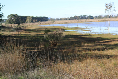
Photograph - Digital photograph, Dorothy Wickham, Winter's Swamp, Ballarat, January to April 2014
Study of Winter's Swamp commissioned by BEN and completed by BHS. The swamp was named after one of the first European settlers in the district. Winter Swamp LAT -37 32 LONG 143 47, Parish of Dowling Forest, County of Grenville Winter Swamp, on the southwest corner of Ballarat West Town Common, was not included in the original proclamation of the Common in 1861. However, being marshland, it was not considered suitable for grazing, so was added to the Common soon after 1861. Winter Swamp is a large wetland with native and exotic pasture significant for wildlife. John Winter (Jock) was born in Berwickshire, Scotland. He married Janet Margaret Irving the daughter of Robert Irving, advocate, Bonshaw, Dumfries, Scotland. Winter died in Ballarat in 1875 and was buried at the Ballaarat Old Cemetery. He took up the run Bonshaw from 1841; Leigh River Buninyong 1842-46; Junction, Delatite, March 1851 to September 1862; with sons: Carag Carag and Corop, April 1857 to September 1872; Colbinabbin and Stewart’s Plains, April 1857 to December 1872; St Germains February 1867 to March 1871. (The name became Winter-Irving in 1890). Mr John Winter, who died on August 22 at the age of 72, was a man of some note it the mining community of Ballarat. He was a self-made man, and one of our oldest colonists, it being over a quarter of a century age since he took up county about Ballarat and settled at Bonshaw. He died very rich. It is calculated that if he had retained an interest in all his runs, his income must have been not less than £10,000 or £50,000 a year. Some eight or ten years ago he sold his Bonshaw pre-emption to the Bonshaw Gold mining Company for £20,000, and a few years later the ground belonging now to Winter's Freehold Company brought him £50,000 more, the payment being made at the requisition of the deceased in sovereigns. In these relations Mr. Winter has been closely identified with the mining industry at Ballarat. The deceased was a native of Lauder, in Berwickshire, and landed in Victoria several years before the gold discovery.The principle task of this project was the delivery of a report outlining the history of European settlement in the Skipton and Cardigan/Ballarat districts as pertinent to the use of and impact on the natural environment of the two reserves Skipton Common and Winter Swamp. The report was delivered in digital form only. The report, upon completion, was presented to the Network’s Committee in order to discuss the project. The report identified and described the uses of Skipton Common and Winter Swamp, and their impacts. In particular, this report examined farming/grazing (official and informal), mining, vegetation removal (including the removal of woodlands for timber, grasslands for pasture improvement) & use of riparian areas for access to water and timber removal. Recording the more benign and environmentally friendly uses such as picnicking, community activities, nature walks and the roles of organisations such as Field Naturalists’ and Bird Observers’ clubs, school and scout/guide groups will be relevant in helping to depict overall community attitudes towards the reserves; e.g.: has the Common generally been viewed as little more than a grazing paddock and fire hazard; has Winter Swamp always been the unknown natural asset that seems to have been its lot for at least the past 40 years? In this regard, the more contemporary history of actions surrounding the use and management of the reserves is of particular interest, in view of the extant evidence at both reserves; e.g. the actions of the Shire of Ballarat in the 1980s in establishing Winter Swamp as something of a competitor to Lake Wendouree but with a more environmental bent (although almost none of the plants used are indigenous species, but that is part of the story); the trotting track constructed on Skipton Common in the 1960s following representations to Premier Henry Bolte and the cropping of the western section of the Common to raise funds for the town’s new swimming pool, the fertilizing of the land putting an end to the native grassland vegetation. There are obviously multiple sources of information to source in preparing the report, however sources that the contractor is specifically requested to consult are the Skipton Historical Society, the former Skipton Common managers (specifically Graeme Pett), the Cardigan Windermere Landcare Group and the Learmonth Historical Society (believed to hold many of the former Shire of Ballarat’s records pertaining to the Council’s role as the Committee of Management for both Winter Swamp and the Ballarat West Town Common – Winter Swamp was split between 2 separate Crown Land tenures). The contractor is also encouraged but not required to utilise community newsletters, such as the Skipton Community Newsletter, to publicise and seek information about the project. Skipton Historical Society (Mary Bradshaw) contacted on Thursday 12 June 2.30pm. Mary lived on a farm out of Skipton but is currently living in the township. She remembers walking along the creek of the Common especially in spring and autumn in bare feet and that it was a very pretty place. There were a few snakes around the waterway in summer. People put cows and a couple of horses on the commonage to graze. Graeme Pett has always lived close to the Common and would know a lot about it. Other possible contacts would be Nicole Petress, Secretary of the Progress Association, and the Corangamite Council, Camperdown. Digital images of Winter's Swampwinter's swamp, ballarat, john winter, ballarat environmental network, mullawullah -
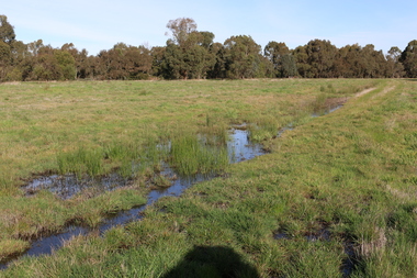 Ballarat Heritage Services
Photograph - Digital photograph, Winter's Swamp surrounds, April 2014
The swamp was named after John (Jock) Winter. John Winter (Jock) was born in Berwickshire, Scotland. He married Janet Margaret Irving the daughter of Robert Irving, advocate, Bonshaw, Dumfries, Scotland. Winter died in Ballarat in 1875 and was buried at the Ballaarat Old Cemetery. He took up the run Bonshaw from 1841; Leigh River Buninyong 1842-46; Junction, Delatite, March 1851 to September 1862; with sons: Carag Carag and Corop, April 1857 to September 1872; Colbinabbin and Stewart’s Plains, April 1857 to December 1872; St Germains February 1867 to March 1871. (The name became Winter-Irving in 1890). Mr John Winter, who died on August 22 at the age of 72, was a man of some note it the mining community of Ballarat. He was a self-made man, and one of our oldest colonists, it being over a quarter of a century age since he took up county about Ballarat and settled at Bonshaw. He died very rich. It is calculated that if he had retained an interest in all his runs, his income must have been not less than £10,000 or £50,000 a year. Some eight or ten years ago he sold his Bonshaw pre-emption to the Bonshaw Gold mining Company for £20,000, and a few years later the ground belonging now to Winter's Freehold Company brought him £50,000 more, the payment being made at the requisition of the deceased in sovereigns. In these relations Mr. Winter has been closely identified with the mining industry at Ballarat. The deceased was a native of Lauder, in Berwickshire, and landed in Victoria several years before the gold discovery. BHS were commissioned by Ballarat Environment Network for a project on Winter's Swamp and Skipton Common. Winter's Swamp was part of Ballarat West Common. The principle task of this project was the delivery of a report outlining the history of European settlement in the Skipton and Cardigan/Ballarat districts as pertinent to the use of and impact on the natural environment of the two reserves Skipton Common and Winter Swamp. The report was delivered in digital form only. The report, upon completion, was presented to the Network’s Committee in order to discuss the project. The report identified and described the uses of Skipton Common and Winter Swamp, and their impacts. In particular, this report examined farming/grazing (official and informal), mining, vegetation removal (including the removal of woodlands for timber, grasslands for pasture improvement) & use of riparian areas for access to water and timber removal. Recording the more benign and environmentally friendly uses such as picnicking, community activities, nature walks and the roles of organisations such as Field Naturalists’ and Bird Observers’ clubs, school and scout/guide groups will be relevant in helping to depict overall community attitudes towards the reserves; e.g.: has the Common generally been viewed as little more than a grazing paddock and fire hazard; has Winter Swamp always been the unknown natural asset that seems to have been its lot for at least the past 40 years? In this regard, the more contemporary history of actions surrounding the use and management of the reserves is of particular interest, in view of the extant evidence at both reserves; e.g. the actions of the Shire of Ballarat in the 1980s in establishing Winter Swamp as something of a competitor to Lake Wendouree but with a more environmental bent (although almost none of the plants used are indigenous species, but that is part of the story); the trotting track constructed on Skipton Common in the 1960s following representations to Premier Henry Bolte and the cropping of the western section of the Common to raise funds for the town’s new swimming pool, the fertilizing of the land putting an end to the native grassland vegetation. There are obviously multiple sources of information to source in preparing the report, however sources that the contractor is specifically requested to consult are the Skipton Historical Society, the former Skipton Common managers (specifically Graeme Pett), the Cardigan Windermere Landcare Group and the Learmonth Historical Society (believed to hold many of the former Shire of Ballarat’s records pertaining to the Council’s role as the Committee of Management for both Winter Swamp and the Ballarat West Town Common – Winter Swamp was split between 2 separate Crown Land tenures). The contractor is also encouraged but not required to utilise community newsletters, such as the Skipton Community Newsletter, to publicise and seek information about the project. Skipton Historical Society (Mary Bradshaw) contacted on Thursday 12 June 2.30pm. Mary lived on a farm out of Skipton but is currently living in the township. She remembers walking along the creek of the Common especially in spring and autumn in bare feet and that it was a very pretty place. There were a few snakes around the waterway in summer. People put cows and a couple of horses on the commonage to graze. Graeme Pett has always lived close to the Common and would know a lot about it. Other possible contacts would be Nicole Petress, Secretary of the Progress Association, and the Corangamite Council, Camperdown. Mary can’t remember any photos in the Skipton Historical Society that pertain to the Common. Digital photos of Winter's swamp surrounds, later known as Mullawullah.winter, winter's swamp surrounds, winter's swap, john winter, ballarat environmental network, ballarat, mullawullah -
 Ballarat Heritage Services
Photograph - Colour, Clare Gervasoni, Entrance to Vaughan Springs, 2017, 16/07/2017
Timber entrance feature to Vaughan Mineral Springs Reserve.vaughan, vaughan springs, vaughan chinese cemetery, chinese, mineral water -
 Ballarat Heritage Services
Photograph - Photograph - Colour, Former Lake Condah Aboriginal Mission, 17/04/2016
The Lake Condah Mission site includes bluestone ruins and a reconstructed timber building, as well as the cemetery which were part of the original settlement. With European settlement in the 1830s came conflict. Gunditjmara people fought for their land during the Eumerella wars, which lasted more than 20 years. As this conflict drew to an end in the 1860s, many Aboriginal people were displaced and the Victorian government began to develop reserves to house them. Many Aboriginal people refused to move from their ancestral land and eventually the government agreed to build a mission at Lake Condah, close to some of the eel traps and within sight of Budj Bim (Mt Eccles). The mission opened in 1867. The Mission was formally closed in 1918, and Aboriginal people were forced off the Mission, some moving to Lake Tyers. The Gunditjmara protested against the Mission’s closure and many continued to reside in the buildings until the majority of the reserve land was handed over to the Soldier Settlement Scheme in the 1940s. The mission was destroyed by the government in the 1950s in an effort to force the integration of Gunditjmara people with the general community but the Gunditjmara people continued to live in the area and protect their heritage. The mission lands were returned to the Gunditjmara in 1987. Lake Condah Mission is a place with special meaning to the Gunditjmara community - as a community meeting place, an administrative centre, a symbol of political struggle and a link to family histories. As a result the Gunditjmara community do not want open public access to this site. Key Features of Interest Ruins of stone cottages and plot remains of buildings such as the church Reconstructed dormitory building (https://www.budjbim.com.au/visit/cultural-sites/lake-condah-mission/?gclid=EAIaIQobChMIz6j36ZvF-QIV8ZhmAh2tmA3qEAAYASAAEgLxrvD_BwE, accessed 2022)Colour photographs of the former Lake Condah Aboriginal Missionlake condah, lake condah aboriginal mission, aborigines, aboriginal, gunditjmara, eumerella wars -
 Robin Boyd Foundation
Drawing - Architectural, Tower Hill State Game Reserve Natural History Centre, 31-Oct-62
Project: Tower Hill State Game Reserve Natural History Centre drawn by J.T.W. of Romberg & Boyd for Public Works Department. Drawing no. 13. Timber beam details.Working Drawing, Dyeline -
 Ballarat Tramway Museum
Functional Object - Electrical conduit, 21/01/2018 12:00:00 AM
Yields information about the materials and the methods of installing electrical domestic cables in Ballarat houses during the 1920's.Section of timber or wooden electrical conduit used in houses c1920, to contain wires for electrical lamps and fittings. Consists of a timber base (very light softwood - ??) with two slots that was nailed to a wall and after the cable installed a cover strip applied. Has one end mitred or cut at 45 degrees. See Early Electrical wiring systems in American buildings - L. D. Mitchelltrams, tramways, esco, electrical equipment, house extensions, houses, electricity -
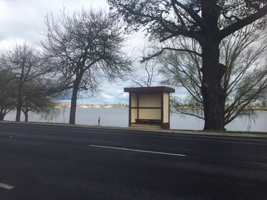 Ballarat Tramway Museum
Photograph - Digital image, Warren Doubleday, Tram stop shelter with flat roof - Wendouree Parade near Dowling St, Sep. 2016
Former tram stop shelter in Wendouree Parade near Dowling St with Lake Wendouree in the background. Maintained by the City of Ballarat.Digital Image of the timber based shelter with flat roof - Wendouree Parade near Dowling St. Photographed 9/1991. See Reg Item 6526i3 for a c1971 image.trams, tramways, shelters, dowling st, wendouree parade