Showing 166 items
matching timber track
-
 Marysville & District Historical Society
Booklet (item) - Information Booklet, Artworkz Tourism, Cumberland Falls, Unknown
An information booklet that was produced as a guide to the Cumberland Falls near Marysville in Victoria.An information booklet that was produced as a guide to the Cumberland Falls near Marysville in Victoria. These falls are located on the Marysville-Wood's Point Road. Cambarville is notable for its giant mountain ash (Eucalyptus regnans) trees within the Cumberland Memorial Scenic Reserve, and relics from former sawmills and gold mining. The Big Culvert is located nearby on the Marysville - Woods Point Road, which was historically part of the Yarra Track. Cambarville was established as a timber mill town in the 1940s. Timber mill owners A Cameron and FJ Barton named Cambarville. They established the mill to salvage timber from trees destroyed in the 1939 bushfires. Cambarville was impacted by the 2009 Black Saturday bushfires and any remaining structures were destroyed.marysville, victoria, photograph, waterfalls, cumberland falls, p. 2328, rose series postcard, souvenir, rose stereograph company, cambarville, marysville-wood's point road, mountain ash, eucalyptus regnans, cumberland memorial scenic reserve, mining, timber milling, big culvert, a cameron, fj barton, black saturday bushfires -
 Marysville & District Historical Society
Photograph (Item) - Black and white photograph, Bridge Over The Cumberland, c1900
An early black and white photograph of a bridge over the Cumberland Creek near Marysville in Victoria.An early black and white photograph of a bridge over the Cumberland Creek near Marysville in Victoria. The Cumberland Creek is in the Cumberland Valley near Cambarville which was a timber town near Marysville. Cambarville is notable for its giant mountain ash (Eucalyptus regnans) trees within the Cumberland Memorial Scenic Reserve, and relics from former sawmills and gold mining. The Big Culvert is located nearby on the Marysville - Woods Point Road, which was historically part of the Yarra Track. Cambarville was established as a timber mill town in the 1940s. Timber mill owners A Cameron and FJ Barton named Cambarville. They established the mill to salvage timber from trees destroyed in the 1939 bushfires. Cambarville was impacted by the 2009 Black Saturday bushfires and any remaining structures were destroyed.ARMSTRONG COLLECTION 42 STATION STREET/ SANDRINGHAM 3191/ TEL. (03) 9521 5442/ IAN M.L. ARMSTRONG OAMcumberland creek, marysville, victoria, cumberland valley, cambarville, mountain ash, eucalyptus regnans, cumberland memorial reserve, the big culvert, marysville-wood's point road, yarra track, a cameron, fj barton, 2009 black saturday bushfires -
 Marysville & District Historical Society
Photograph (Item) - Black and white photograph, Way to Cumberland Falls, c1900
An early black and white photograph of the forest near the Cumberland Falls in Victoria.An early black and white photograph of the forest near the Cumberland Falls in Victoria. The falls are located on the Marysville-Wood's Point Road. Cambarville is notable for its giant mountain ash (Eucalyptus regnans) trees within the Cumberland Memorial Scenic Reserve, and relics from former sawmills and gold mining. The Big Culvert is located nearby on the Marysville - Woods Point Road, which was historically part of the Yarra Track. Cambarville was established as a timber mill town in the 1940s. Timber mill owners A Cameron and FJ Barton named Cambarville. They established the mill to salvage timber from trees destroyed in the 1939 bushfires. Cambarville was impacted by the 2009 Black Saturday bushfires and any remaining structures were destroyed.ARMSTRONG COLLECTION 42 STATION STREET/ SANDRINGHAM 3191/ TEL. (03) 9521 5442/ IAN M.L. ARMSTRONG OAMcumberland falls, cambarville, marysville, victoria, waterfalls, postcard, souvenir, mountain ash, mining, timber mills, big culvert, yarra track, a cameron, fj barton, black saturday bushfires, 1939 bushfires, eucalyptus regnans -
 Marysville & District Historical Society
Photograph (Item) - Black and white photograph, Cumberland Falls, c1900
An early black and white photograph of Cumberland Falls near Marysville in Victoria.An early black and white photograph of Cumberland Falls near Marysville in Victoria. These falls are located on the Marysville-Wood's Point Road. Cambarville is notable for its giant mountain ash (Eucalyptus regnans) trees within the Cumberland Memorial Scenic Reserve, and relics from former sawmills and gold mining. The Big Culvert is located nearby on the Marysville - Woods Point Road, which was historically part of the Yarra Track. Cambarville was established as a timber mill town in the 1940s. Timber mill owners A Cameron and FJ Barton named Cambarville. They established the mill to salvage timber from trees destroyed in the 1939 bushfires. Cambarville was impacted by the 2009 Black Saturday bushfires and any remaining structures were destroyed.ARMSTRONG COLLECTION 42 STATION STREET/ SANDRINGHAM 3191/ TEL. (03) 9521 5442/ IAN M.L. ARMSTRONG OAMcumberland falls, cambarville, marysville, victoria, waterfalls, postcard, souvenir, mountain ash, mining, timber mills, big culvert, yarra track, a cameron, fj barton, black saturday bushfires, 1939 bushfires, eucalyptus regnans -
 Marysville & District Historical Society
Booklet - Information booklet, Ann Thomas, Wilks Creek Bridge, 1993
A history of the Wilks Creek Bridge and its connection to the Yarra Track.Paperback. Front cover has an old photograph of the Wilks Creek Bridge.non-fictionA history of the Wilks Creek Bridge and its connection to the Yarra Track.wilks creek bridge, yarra track, narbethong, marysville, victoria, clement wilks, wood's point goldfields, jordan goldfields, john monash, monash and anderson, 2009 black saturday bushfires -
 Marysville & District Historical Society
Photograph (Item) - Colour photograph, Pre 2009
A colour photograph of the Wilks Creek Bridge near Marysville in Victoria.A colour photograph of the Wilks Creek Bridge near Marysville in Victoria. The Wilks Creek Bridge is a former timber and bluestone road bridge on the Yarra Track, and is located just off the Black Spur route, between Narbethong and Marysville, Victoria, Australia. It was built in 1870 to the design of colonial Public Works Department engineer Clement Wilks as part of the construction of a new road to the Woods Point and Jordan Goldfields. Like many bridges of the period, it had a timber superstructure employing squared beams supported by struts and straining pieces, on cut bluestone abutments. The bridge was remodelled around 1900 by engineer John Monash of the famous bridge-engineering firm of Monash and Anderson. It was last used for heavy vehicular traffic in 1980 following the realignment of Marysville Road, and was left to decay until its demolishment in 2008. All timber traces of the bridge were destroyed in the 2009 Black Saturday fires. The handcrafted bluestone masonry wingwalls and abutments, especially shaped to receive timber struts, rate among the earliest of its kind surviving intact in Victoria.wilks creek bridge, yarra track, narbethong, marysville, victoria, clement wilks, wood's point goldfields, jordan goldfields, john monash, monash and anderson, 2009 black saturday bushfires -
 Marysville & District Historical Society
Photograph (Item) - Black and white photograph, 1993
A black and white photograph taken at the re-opening of the Wilks Creek Bridge picnic area and launch of Ann Thomas' book Wilks Creek Bridge.A black and white photograph taken at the re-opening of the Wilks Creek Bridge picnic area and launch of Ann Thomas' book Wilks Creek Bridge. The Wilks Creek Bridge is a former timber and bluestone road bridge on the Yarra Track, and is located just off the Black Spur route, between Narbethong and Marysville, Victoria, Australia. It was built in 1870 to the design of colonial Public Works Department engineer Clement Wilks as part of the construction of a new road to the Woods Point and Jordan Goldfields. Like many bridges of the period, it had a timber superstructure employing squared beams supported by struts and straining pieces, on cut bluestone abutments. The bridge was remodelled around 1900 by engineer John Monash of the famous bridge-engineering firm of Monash and Anderson. It was last used for heavy vehicular traffic in 1980 following the realignment of Marysville Road, and was left to decay until its demolishment in 2008. All timber traces of the bridge were destroyed in the 2009 Black Saturday fires. The handcrafted bluestone masonry wingwalls and abutments, especially shaped to receive timber struts, rate among the earliest of its kind surviving intact in Victoria.wilks creek bridge, yarra track, narbethong, marysville, victoria, clement wilks, wood's point goldfields, jordan goldfields, john monash, monash and anderson, 2009 black saturday bushfires -
Marysville & District Historical Society
Document (Item) - Heritage Report, Biosis Research Pty Ltd, Heritage Report-Dismantling of Wilks Creek Brdige Deck Marysville, Unknown
A heritage report on the dismantiling of the Wilks Creek Bridge deck in Marysville in Victoria.A heritage report on the dismantiling of the Wilks Creek Bridge deck in Marysville in Victoria. The Wilks Creek Bridge is a former timber and bluestone road bridge on the Yarra Track, and is located just off the Black Spur route, between Narbethong and Marysville, Victoria, Australia. It was built in 1870 to the design of colonial Public Works Department engineer Clement Wilks as part of the construction of a new road to the Woods Point and Jordan Goldfields. Like many bridges of the period, it had a timber superstructure employing squared beams supported by struts and straining pieces, on cut bluestone abutments. The bridge was remodelled around 1900 by engineer John Monash of the famous bridge-engineering firm of Monash and Anderson. It was last used for heavy vehicular traffic in 1980 following the realignment of Marysville Road, and was left to decay until its demolishment in 2008. All timber traces of the bridge were destroyed in the 2009 Black Saturday fires. The handcrafted bluestone masonry wingwalls and abutments, especially shaped to receive timber struts, rate among the earliest of its kind surviving intact in Victoria.wilks creek bridge, yarra track, narbethong, marysville, victoria, clement wilks, wood's point goldfields, jordan goldfields, john monash, monash and anderson, 2009 black saturday bushfires -
Alexandra Timber Tramway & Museum
Black and white photo, Rubicon tram track
black and white photo of tram tracks in to bush these tracks were layed to harvest timber and build hyrdo power system .note wooden rails .man standing beside tree fern . in good condrubicon tram tracks -
Alexandra Timber Tramway & Museum
Mr Sapsford, rubicon channel and tram tracks
Photograph of local event .Building of Rubicon power house ( station ) Detail of construction evedent in photoUn replaceable .record of local eventsrubicon photo of channel and tram tracks, put in to feed hydro system .note tree harvest and elevated channel to the right taken by mr sapsford of alexandrarubicon channel and tram tracks -
Alexandra Timber Tramway & Museum
Rubicon black and white photo, rubicon Pipeline at Haulage at rubicon
rubicon pipeline at haulage at rubicon .Note tram tracks beside pipeline also men working on pipe with A frame .Mr Sapsford of Alexandra .In good condrubicon Pipline up haulage rubicon -
Federation University Historical Collection
Book, From Timber to Tourism: Exploring Place Attachment and Natural Area Values in the Otway Ranges, 1997
Spiral bound reportuniversity of ballarat, school of business, tourism, apollo bay, otway national park, michelle brown, melinda gill, clare kearns, sarah mcewing, renee walder, cape otway lighthouse, point franklin residential estate, harbour, sand dune erosion, great ocean road, blanket bay, maits rest walking track -
 Bendigo Historical Society Inc.
Slide - ALBERT RICHARDSON COLLECTION: NEW CHUM RAILWAY GOLD MINE
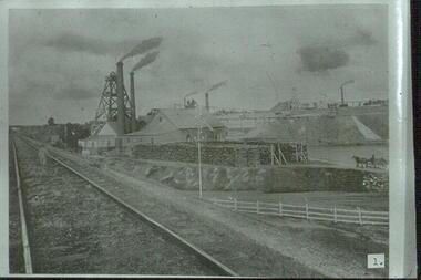
Slide: railway track running alongside New Chum Mine, Breen Street, Golden Square, Bendigo. Mine buildings on right hand side of track, chimneys, poppet head, horse and dray and large stacks of timber in foreground of image. Boy standing on rail way line.number 1 in blackmine, gold, new chum railway, poppet heads, chimney stacks, timber stacks, 3 mine bridges, horse and dray, mining, bendigo, gold mining, railway line, new chum mine -
 National Vietnam Veterans Museum (NVVM)
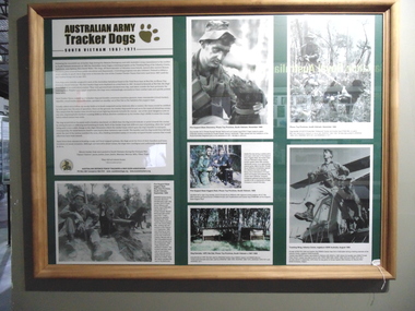
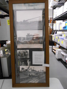
Poster - Framed Information board, Australian Army Tracker Dogs
A framed display in natural timber with the story of the Australian Army Tracker Dogs in South Vietnam 1967 - 1971. Six photographs each have a description. Names of the soldiers and dogs are Pte Phil Little, dog Caesar, Pte Bruce Williams and Pte John Featherstone with dog Milo, Pte Russell "Mooka" McDonald with dog Trajan, Pte Bob "Hollywood" Hunter with dog Milo. Coloured photograph of the Dog Kennels at 1 ATF, Nui Dat, Phuoc Tuy Province.tracker dog, 1 atf base, pte phil little, nui dat, phuoc tuy province, pte bruce williams, pte john featherstone, dogs, mcdonald, mooka mcdonald, featherstone, tracker -
 National Vietnam Veterans Museum (NVVM)
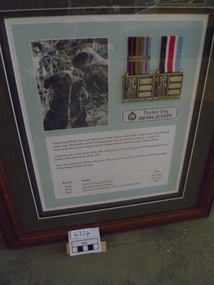
Photograph, Tracker Dog D6N04 Justin
Stained timber frame, dark green matt board conatining photo of Justin having cup of water poured over head. Two Silver service medals with ribbons and service record in Vietnamd6n04, justin, tracker dogs, 7 rar, pte tom blackhurst, australian army training team -
 Ithacan Historical Society
Photograph, Ithaca earthquake, 1953
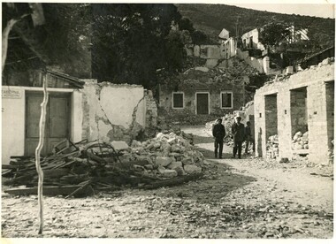
The photograph was taken after the massive earthquakes of 1953 which caused widespread destruction across Ithaca and other Ionian Islands. Many of the buildings destroyed in the earthquake could not be rebuilt and some parts of the villages became uninhabitable. This event brought about the largest mass migration from the island and a further wave of Ithacan migration to countries, such as Australia and South Africa, where relatives had already settled. The Ithacan Philanthropic Society established an Earthquake Appeal to assist their compatriots.A black and white photograph showing widespread damage done in the aftermath of an earthquake. Many houses are in ruins and there are two heaps of rubble comprising timber and metal and concrete in the foreground. Two men are walking along a track looking at the destruction in the village. -
 Bendigo Historical Society Inc.
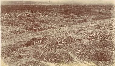
Postcard - ACC LOCK COLLECTION: SEPIA PHOTO OF A WW1 BATTLEGROUND, POSTCARD, 1914-1918
Postcard, WW1, sepia photo of a battleground devastation. Timber strewn about on either side of a dirt track. Handwritten in pencil on the back - Bullecourt the village.postcard, postcard, ww1, france, bullecourt -
 National Vietnam Veterans Museum (NVVM)
Photograph
Three coloured Photograph framed in black timber with white matting. 1. An APC used to transport an ambush party onto an NVA track. 2. Pte Robertson and Pte Donnelly on a routine perimeter sweep at FSB Balmoral 3. 3RAR conducting a routine perimeter sweep of FSB Balmoralphotograph, battle of balmoral, 3 rar, coral balmoral, battle of coral-balmoral -
 National Vietnam Veterans Museum (NVVM)
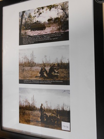
Photograph, US Forces
Timber Framed Collage of Black and White Photograph. Collage of five Photograph showing US Artillery Pieces and Weaponry. 1. Long Tom Artillery 2. Radar controlled self loading tank gun. 3. Weapon Training 4. Camp Communications at Ben Huh 5. APC running along railway tracksUS Army Starphotograph, armoured personnel carrier, tank, long tom -
 Benalla Art Gallery
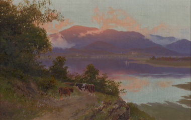
Painting, W. C. PIGUENIT, Mt Wellington at sunrise: a view from Risdon Cove towards Glenorchy, c. 1870
Born: Hobart, Tasmania, Australia 1836; Died: Hunter's Hill, New South Wales, Australia 1914RomanticismLedger Gift, 1976Rural landscape with cows, track, lake and large mountains and clouds. Golden gesso painted timber frame.Recto: Signed "W. C. Piguenit" in black oil in l.l.c of composition; Not dated; Not titledpainting, landscape, water, animals, cows, boats, trees, mountains, clouds, sky, colonial, reflections -
 Benalla Art Gallery
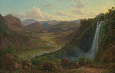
Painting, Eugene VON GUERARD, The fall of the Veliono near Terni with the view up the Valley of the River Nera, 1885
Born: Vienna, Austria 1811; Arrived: Melbourne, Victoria, Australia 1852; Died: London, Middlesex England 1901RomanticismLedger Gift, 1984Rural valley and mountain landscape with two figures walking down a track beside a waterfall towards a river. Gold brushed gesso decorative edged timber frame.Recto: Signed and dated "Eug.V.Guérard / D. 85" in red oil in l.r.c of composition; Not titledpainting, landscape, river, cliff, mountain, figures, buildings, waterfall, sky, clouds -
 Benalla Art Gallery
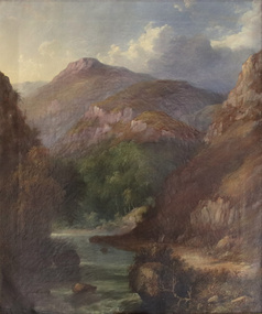
Painting, J. H. CARSE, Mountain River, 1866
Born: Edinburgh, Scotland c.1818; Arrived: Melbourne, Victoria, Australia c.1867; Died: Sydney, New South Wales, Australia 1900VictorianGift of Mrs E.E. Ledger, 1985Rural landscape with dirt track, narrow stream, trees and steep mountains. Gold brushed and painted timber frame.Recto: Signed and dated “J H Carse / 1866” in brown oil, l.r.c of composition; Not titled painting, landscape, mountains, river, clouds, sky, trees -
 Benalla Art Gallery
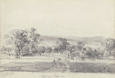
Drawing, Louis BUVELOT, Melbourne Kew (Yarra Glen), 1869
Born: Morges, Vaud, Switzerland 1814; Lived and worked: Brazil 1835-1852; Arrived: Melbourne, Victoria, Australia 1865; Died: Melbourne, Victoria, Australia, 1888ColonialLedger Gift, 1987Rural landscape with two animals beside a track leading towards buildings and outbuildings surrounded by trees with hills in distance. Timber frame.Recto: Signed "Louis Buvelot" in grey pencil in l.l.c of composition; Titled and dated 'Melbourne Kew 1869' in grey pencil in lower centre of compositiondrawing, landscape, figures, trees, colonial, road, animals -
 Puffing Billy Railway
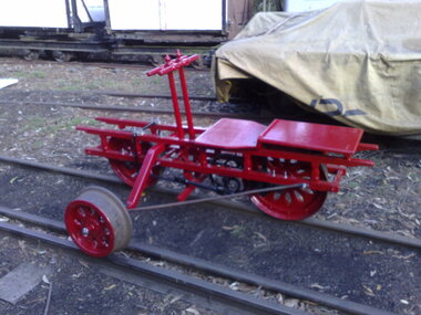
Hand Tricycle Number 386, Commonwealth Railways 3'6" Gauge Hand Tricycle
The trolley entered service for the Commonwealth Railways (later Australian National Railways) as trolley number "386" and was originally built to the gauge of 3"6.Historic - Commonwealth Railways - Narrow Gauge Railway - Track vehicleThe tricycle is red and has three wheels, two large on one side with a single offset wheel on the other. Timber and steel constructionhand tricycle, commonwealth railways, australian national railways, trolley, puffing billy -
 Puffing Billy Railway
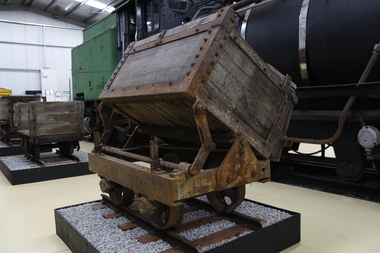
Side Tipping Timber Skip, circa 1900?
Side Tipping Timber Skip Wooden Contractors Wagon. Gauge 17 inch (430mm) Typical of the many side tipping wagons used for soil and rock disposal in construction work and mining throughout Australia and the world. The wagon would be loaded with soil and pushed along a short line to the end of track where the load would be emptied out to either side. By using a central pivot the wagon’s body can be tipped either side to allow the contents to be easily removed ready for the next load.Historic - Industrial Narrow Gauge RailwayWooden bodied, steel framed side tipping skip.puffing billy, side tipping skip, industrial narrow gauge railway -
 Puffing Billy Railway
Emerald Station Sign
Station Sign - Emerald Emerald Station is situated on the Puffing Billy Railway in Victoria, Australia. It was opened with the Railway on 18 December 1900 and comprised a platform track and a loop siding. A passing loop was added between the two a few years later. There was also a spur siding off the Down end of No. 3 Road. Two standard 12 ft by 20 ft timber portable station buildings with a Van Goods Shed between (all adjoining) were provided on the platform and a Goods Shed on the No. 3 Road loop siding. Other buildings included Tea Rooms, lamp room and toilets along with a cattle race and loading bank. The station building was later reduced in length by one of the portables which housed the General and Ladies' waiting rooms. Emerald today remains very similar to the early days, but has had other Roads added into a Carriage Workshops, a turntable and storage sidings. Also, a Signal and Telegraph Branch depot in the form of a large Goods Shed and a multi-purpose yard building in the form of a Locomotive Depot administration building have been added. During 2009, the station building underwent stage one of an internal restoration to its former glory. ref: https://en.wikipedia.org/wiki/Emerald_railway_station,_Victoria photos at http://www.vicrailstations.com/Gembrook/Emerald/Emerald.html Historic - Victorian Railways Station sign used at Emerald Station Station Sign - Emerald Metal rectangle Station Name Sign with white enamel back ground and black lettersEmeraldstation sign, puffing billy, emerald station