Showing 615 items
matching tower house
-
 Glenelg Shire Council Cultural Collection
Photograph - Photograph - view of Henty's Beach, Portland, 1930s
Black and white photo, white border. View of Henty Beach Portland, looking north to water tower, Whaler's Bluff, spire of the All Saints Catholic Church. Cars on beach in foreground, numerous people on sand / in water, Railway Pier and Baths visiblephotography, henty beach, portland, whalers bluff -
 Glenelg Shire Council Cultural Collection
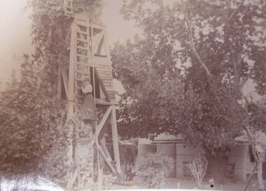
Photograph - Photograph - Daisy Bree up the Mill at Bewsall, Esther Winifred Hill, 1934
Photographs taken by Esther Winifred Hall (nee Smallpage) - great grand-daughter of Stephen George Henty. Taken in 1934 Centenary Celebrations in Portland.Black and white photograph showing wooden tower surrounded by trees, a woman is half-way up a ladder on side of tower.Front: (no inscriptions)esther winifred hall, henty, 1934, portland centenary -
 Glenelg Shire Council Cultural Collection
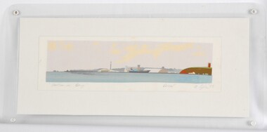
Print, Portland Bay, 1983
CEMA Art Collection Part of "A Community View" 150 years in Portland Screenprint Exhibition Part of Angela Gee Residency 1983 and 1984Laminated screenprint of Portland Bay. Wide angle view of the Bay, with water tower / lighthouse on the right, the harbour with a docked ship in the centre, and the end of the peninsular and ocean on the left.Front: "Portland Bay" (lower left) Proof (lower right centre) A Gee '83 (lower right) (pencil) Back: 12 -
 Glenelg Shire Council Cultural Collection
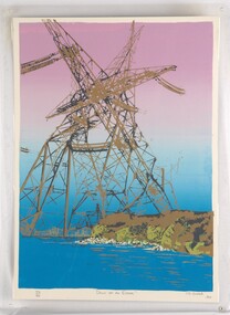
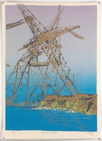
Print, Dawn of an Error, 1984
CEMA Art Collection. Part of "A Community View" 150 years in Portland Screenprint Exhibition. Part of Angela Gee Residency 1983 and 1984.Laminated screenprint of high tension electricity towers on top of coastline. The foreground shows the ocean with white rocks and the cliffs of the coastline in gold and various shades of green. The electricity towers are black and gold and printed on a purple and blue background.Front: 40/60 (lower left) "Dawn of an Error" (lower centre) CJ Snook '84 (lower right) (pencil) Back: 29 -
Glenelg Shire Council Cultural Collection
Magazine, 150th Victoria Anniversary Souvenir, Sun News Pictorial, 1985
Coloured night view of Sydney Myer Music Bowl with City of Melbourne in background. Back cover coloured night view of Arts Centre Tower with City in background. -
 Glenelg Shire Council Cultural Collection
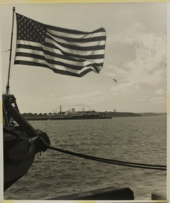
Photograph - Photography, Con Kroker, Harbour Opening, 1960s
Con Kroker Private CollectionBlack and white photo of part of Portland Harbour Opening celebrations, 1960. A steamship decorated with bunting is berthed at Ocean Pier. An American flag attached to a vessel in foreground. Water tower and lighthouse in background. -
Glenelg Shire Council Cultural Collection
Photograph - Photograph - Discharging coffee beans - Nedlloyd Fremantle, n.d
Port of Portland Authority archives.Front: (no inscriptions) Back: Discharging coffee beans - Nedlloyd Fremantle (lower right, blue pen).port of portland archives -
 Glenelg Shire Council Cultural Collection
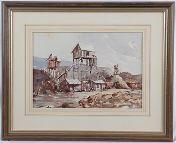
Painting, Noel Jones, Stone Quarry, 1974
NoneView of a quarry. In the centre of the image a conveyor belt runs up from a pile of rubble to a small hut on tall stilts. A conveyor belt runs down from this hut to an orange truck. Below and to either side of the stilted building are two wooden buildings with tin rooves. A stilted tower is depicted in maroon to the left, and another in the distance to the right. Mounds, painting in brown, yeloow, grey and shades of blue run across the centre of the image, below a sky washed with blue and highlighted with orange. Mounted in a decorative matt, in wooden frame with glass.Front: N. W. Jones 74 (lower left, blue paint) Back: 1974 (upper left, pencil) -
Glenelg Shire Council Cultural Collection
Banner - Banner - Tomorrow's Possibilities, Nov-10
-
Glenelg Shire Council Cultural Collection
Photograph - Photograph - Discharging coffee beans - Nedlloyd Fremantle, n.d
Port of Portland AuthorityFront: (no inscriptions) Back: (no inscriptions)port of portland archives -
Glenelg Shire Council Cultural Collection
Photograph - Photograph - Discharging coffee beans - Nedlloyd Fremantle, n.d
Port of Portland Authority archives.Front: (no inscriptions) Back: Discharging coffee beans - Nedlloyd Fremantle (lower right, pen).port of portland archives -
Glenelg Shire Council Cultural Collection
Photograph - Photograph - six contact prints of silo construction, 1964
Port of Portland Authority ArchivesSheet of (6) black and white contact prints relating to Silo Construction. First and fourth photo's are of the corner KS Anderson Wharf and some construction equipment. Second and third metal tower being constructed. Fifth shed on KS Anderson. Sixth photo completed structure of metal tower.Front: 2. 28-2-64 3. 28-2-64 4. 10-3-64 5. 5-3-64 6. 5-3-64 7. 10-3-64 (Under each of the prints, in white.)port of portland archives, construction, silo, k s anderson wharf -
Glenelg Shire Council Cultural Collection
Photograph - Photograph - Vacuum Oil Co., Portland, n.d
Black and white photograph. Vacuum Oil Co Portland. Taken from elevated position. Fuel tanks, brick 3 bay shed, tower and pond, pumps and shelter, section of oval shaped lawn in centre. same premises as 8416, 8417Back: '89' in pencil. Round purple stamp 'Hunter's Same day service'portland harbour, industry -
Glenelg Shire Council Cultural Collection
Map - Map - RACV Road Map, 1970s
RACV road map, Warrnambool District, Port Fairy to Lorne. Large coloured map of Warrnambool District. Small maps of Apollo Bay, Colac, Camperdown, Tower Hill and Warrnambool. When folded, black and white photo on cover of 12 Apostlesracv, road touring, road map, victoria -
Glenelg Shire Council Cultural Collection
Book, THE CAMBRIDGE HISTORICAL READERS, c. 1914
Hard back, olive black print and outline of tower spires. 'British History text, black and white photographs and maps -
 Glenelg Shire Council Cultural Collection
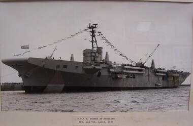
Photograph - Photograph - HMAS Sydney at Portland, 1970, 1970
On display at History House.Black and white photograph of a ship next to a stone jetty. The ship is festooned with flags from stern to central radar tower. Many people are on the deck at the prow ship and many more are visible on the jetty in background left. Ship bears the numbers : "P2142" towards the prow. Mounted in cream matt, under glass in white wooden frame. HMAS Sydney at Portland, 6th & 7th April, 1970Front: H.M.A.S. Sydeny at Portland 6th & 7th April, 1970 (typed label, lower centre). Back: (no inscriptions)hmas sydney, 1970, portland harbour -
 Glenelg Shire Council Cultural Collection
Print, Dawn of an Error, 1984
Laminated screenprint of high tension electricity towers on top of coastline. The foreground shows the ocean with white rocks and the cliffs of the coastline in gold and various shades of green. The electricity towers are black and gold and printed on a purple and blue background. -
Glenelg Shire Council Cultural Collection
Photograph - Photograph reprint of scan of a photograph - Casterton Hospital, n.d
Vern McCallum CollectionReprint of scan of black and white photograph. Image of Casterton Hospital. Single storey brick building, verandah, lace iron work. White post and rail fence in front. Small tower with turret at left end of building. Several nursing staff and patients on verandah. Print is mounted on white, archival mount board frame. -
Glenelg Shire Council Cultural Collection
Negative - Negative - View from Henty Beach lawns Portland, Victoria, Zilah Maschmedt, c. 1934
Negative for a black and white photograph. Image shows view from Henty Beach lawns, looking towards Whaler's Bluff. Beach shelters, samd,, Railway Pier, Baths, Ocean Pier, lighthouse and water tower on Whaler's Bluff. -
Glenelg Shire Council Cultural Collection
Photograph - Photograph - Tower erection, n.d
Sourced from Casterton Town Hall (Former Shire of Glenelg)Black and white photo. A tower being erected.Back: '31/2 " ' on blue biro line arrowed both ends, drawn across photo -
Glenelg Shire Council Cultural Collection
Photograph - Photograph - grain on KS Anderson Wharf, n.d
Port of Portland Authority Archivesport of portland archives, portland, corkscrew, tug, trewalla, grain -
Glenelg Shire Council Cultural Collection
Photograph, Contact prints of Silo construction, 1964
Port of Portland Authority ArchivesFront: 171. 13-11-64 172. 13-11-64 173. 13-11-64 178. 13-11-64 179. 13-11-64 180. 13-11-64 (In white underneath each print). Back: 178 and 180 in pencilport of portland -
Glenelg Shire Council Cultural Collection
Photograph - Photograph - grain storage, n.d
Port of Portland Authority Archivesport of portland archives, grain silos, k s anderson wharf -
Glenelg Shire Council Cultural Collection
Photograph - Photograph - Silo Construction, n.d
Port of Portland Authority ArchivesBack: June 9th - pencilport of portland archives, grain silos -
Glenelg Shire Council Cultural Collection
Photograph, Sheet of contact prints, 1964
Port of Portland Authority ArchivesFront: 68. 7-8-64 67. 7-8-64 69. 18-8-64 59. 7-8-64 60. 7-8-64 61. 78-64 (In white, beneath each print).port of portland, silo construction -
Glenelg Shire Council Cultural Collection
Photograph - Photograph - Silo Construction, 1964
Port of Portland Authority ArchivesBack: Blue Portland Harbour Trust Stamp 195. 18-12-64 in black ink.port of portland archives, silo construction -
Glenelg Shire Council Cultural Collection
Photograph - Photograph - grain on K. S. Anderson Wharf, n.d
Port of Portland Authority Archivesport of portland archives, grain silos, k s anderson wharf -
Glenelg Shire Council Cultural Collection
Photograph - Sheet of contact prints - silo construction, 1964
Port of Portland Authority ArchivesFront: 2. 28-2-64 4. 28-2-64 5. 5-3-64 6. 5-3-64 7. 10-3-64 3. 28-2-64port of portland archives, grain silos, k s anderson wharf -
Glenelg Shire Council Cultural Collection
Photograph - Sheet of (6) contact prints of silo construction, 1964
Port of Portland Authority ArchivesFront: 112. 30-9-64 113. 30-9-64 114. 30-9-64 117. 30-9-64 118. 30-9-64 124. 30-9-64port of portland archives -
Glenelg Shire Council Cultural Collection
Photograph - Photograph - silo construction, 1964
Port of Portland Authority ArchivesBack: Blue Portland Harbour Trust Stamp 182. 13-11-64 in black ink.port of portland archives, silos