Showing 2474 items
matching township
-
 Greensborough Historical Society
Photograph - Digital Image, Greensborough township c1900, 1900s
This photograph shows a very rural Township of Greensborough around 1900.Digital copy of black and white photographmain street greensborough, greensborough -
 Stawell Historical Society Inc
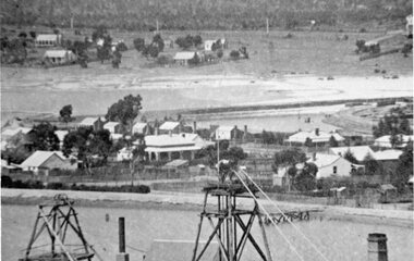
Photograph, Stawell Township looking towards Wild Cat Hill 1880
Stawell Township looking towards Wild Cat Hill 1880stawell -
 Stawell Historical Society Inc
Photograph, Panorama of Stawell Township taken from Big Hill
Stawell Township looking towards Wild Cat Hill 1880stawell -
 Malmsbury Historical Society
Photograph (Item), Malmsbury Township From Western Vantage Point, Malmsbury ca1950
People - Young Family Buildings - Township/Football Oval/Willows -
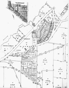 Ringwood and District Historical Society
Photograph, Parish Map - Township of Ringwood - 1890
Written on backing sheet, 'SLV Parish Map Collection. Vol.67, Fol. 43, 1890'. Catalogue card reads, 'SLV Parish Map Collection 1890. (Township of Ringwood). -
 Stawell Historical Society Inc
Photograph, Mafeking Goldfield at Mt William with Businesses in the township c1900
Mafeking Goldfield Mt William Mining Scene c1900. Businesses in the township.stawell -
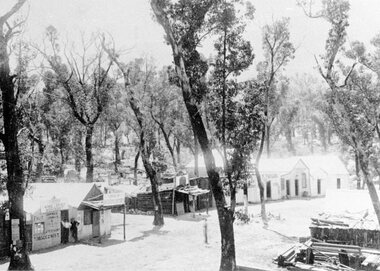
 Kiewa Valley Historical Society
Folder - Early History of Mt Beauty Township, Early History of Mt Beauty Township compiled with contributions by residents of Mt Beauty
To Compile the history of Mt Beauty Township residents were asked to contribute with their reminiscences. Thick white folder held by 2 steel rings at the spine. The first page is an index listing the 'Folio Number' (14) and Description of the content in each folio. Each folio is in a clear plastic sleeve. Some folios are hand written and some are typed.In blue pen Folios 13 and 14 have 'Voters List/Voters Roll' with description added to the list. george paterson, adrian rufenacht, roly wilson, roly whitehead, jim gardner, ron white, mt beauty -
 Clunes Museum
Map - CLUNES MAP SHOWING STREETS AND LOT NUMBERS
PURCHASED FROM DONORMAPS, PARISH OF CLUNES, CLUNES TOWNSHIPCLUNES TOWNSHIP AND STREETSlocal history, document, maps, clunes township -
![Township of Lorne, and Loutitt Bay / [by] Nicholas Caire, circa 1876](/media/collectors/550653872162f11fb04854aa/items/5783458ad0cdd1176c6f0c78/item-media/578345eed0cdd1176c6f852b/item-fit-380x285.jpg) Kew Historical Society Inc
Kew Historical Society IncPhotograph, Anglo-Australasian Photographic Company, Township of Lorne, and Loutitt Bay, c. 1876
Nicholas Caire was born on Guernsey in the Channel Islands in 1837. He arrived in Adelaide with his parents in about 1860. In 1867, following photographic journeys in Gippsland, he opened a studio in Adelaide. From 1870 to 1876 he lived and worked in Talbot in Central Victoria. In 1876 he purchased T. F. Chuck's studios in the Royal Arcade Melbourne. In 1885, following the introduction of dry plate photography, he began a series of landscape series, which were commercially successful. As a photographer, he travelled extensively through Victoria, photographing places few of his contemporaries had previously seen. He died in 1918. Reference: Jack Cato, 'Caire, Nicholas John (1837–1918)', Australian Dictionary of Biography.An original, rare photograph from the series 'Views of Victoria: General Series' by the photographer, Nicholas Caire (1837-1918). The 60 photographs that comprise the series were issued c. 1876 and reinforced a neo-Romantic view of the Australian landscape to which a growing nationalist movement would respond. Nicholas Caire was active as a photographer in Australia from 1858 until his death in 1918. His vision of the Australian bush and pioneer life had a counterpart in the works of Henry Lawson and other nationalist poets, authors and painters.‘Township of Lorne, and Loutitt Bay’ : Views of Victoria (General Series) No.60 : Albumen silver photograph | Photo on card with Title and Description on reverse | Mounted 24 x 30 cm; Photo 12 x 17 cm.On Reverse: ‘Loutitt Bay is fast becoming one of the most fashionable Watering-places in Victoria, partly from its easy access by Rail, combined with the magnificent scenery to be found in the Cape Otway Ranges, and the very moderate charges of the houses of accommodation. The large house near the foreground is that of Mr. Mountjoy, which is a Restaurant. Duncan’s Hotel can be seen in the distance, on the brow of the hill.’nicholas caire (1837-1918), lorne (vic), duncan's hotel, loutitt bay, landscape photography - victoria -
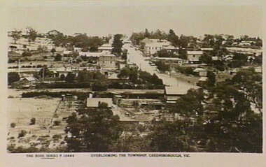 Greensborough Historical Society
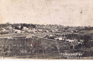
Photograph - Digital Image, Rose Series Postcards, Overlooking the township of Greensborough 1929, 1929_
Photograph of Greensborough taken from a Rose Series postcard titled "Overlooking the township of Greensborough".Historic view of GreesboroughDigital copy of black and white photographgreensborough 1929, rose series postcards -
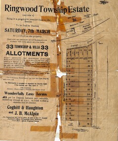 Ringwood and District Historical Society
Flyer, Auction Sale Advertisements - Ringwood Township Estate, Ringwood, Victoria - 1914
Advertisements for auction sale of Ringwood Township Estate (Section A) - Saturday, 7th March (1914), showing subdivision layout, terms of sale, and summary of local features and services. Un-named newspaper clipping advertising this auction also attached.Subdivision includes West Prussia Road (later Wantirna Road), Station Street, and James Street. Agents in conjunction - Coghill & Haughton and J.B. McAlpin. Sale by order of Mrs. E. Kendall. -
 Kew Historical Society Inc
Map, Robert Russell, Map Shewing the Site of Melbourne and the Position of the Huts & Buildings Previous to the Foundation of the Township by Sir Richard Bourke in 1837
Map shows the first layout of Melbourne by Government surveyor Robert Russell, who accompanied Governor Richard Bourke in 1837. The surveyed blocks extend from present-day Flinders Street to Lonsdale Street, and Spring Street to Spencer Street, with extensive vacant land west to a salt lake (afterwards Batman's Swamp, later drained), north beyond Flagstaff Hill and south towards South Melbourne. Vegetation coverage is indicated, and tracks and existing buildings and cultivated land are shown.Printed map was created by Day & Haghe, Lithographers to the Queen, sometime after 1838, when the company received its Royal appointment. Copies of the 1837 map exist in several major map collections in Australia; most are uncoloured. This particular map is the earliest in the Kew Historical Society's map collection. It is a nationally significant artefact. Black and white lithographed map hand-coloured in blue and yellow gouache of the town of Melbourne in 1837. In contrast to the original lithograph, the river and the township blocks are coloured blue and yellow. A similar, partly coloured copy is in the collection of the University of Melbourne.maps - melbourne - 1830s, governor sir richard bourke, robert russell - surveyor, cartography -
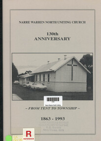 Narre Warren and District Family History Group
Book, Max Thomson, Narre Warren North Uniting Church. 130th Anniversary - From Tent to Township. 1863 - 1993, 1993
Written for the 130th anniversary the book chronicles the church's history and the people who have been associated with it.12 pagesnon-fictionWritten for the 130th anniversary the book chronicles the church's history and the people who have been associated with it.narre warren north (vic.), narre warren north uniting church -
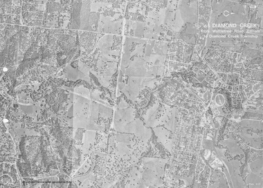 Eltham District Historical Society Inc
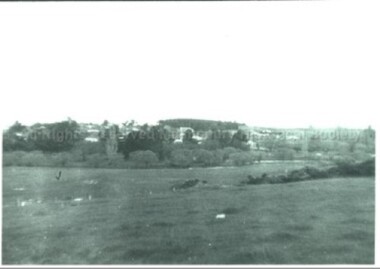
Work on paper (Sub-Item) - Photograph, Diamond Creek from Wattletree Road, Eltham to Diamond Creek township
Black and white aerial view of Diamond Creek from Wattletree Road, Eltham to Diamond Creek Townshipeltham, drain, diamond creek -
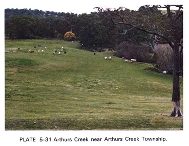 Eltham District Historical Society Inc
Work on paper (Sub-Item) - Photograph, Arthurs Creek near Arthurs Creek township, 1976
Colour photograph of Arthurs Creek near Arthurs Creek township. Hilly grassed landscape with cattle in the backgroundarthurs creek, cattle, farm -
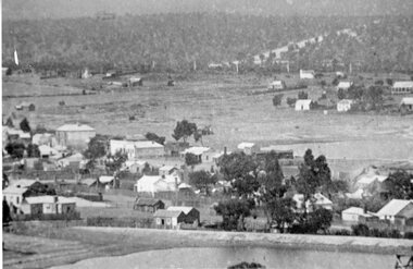
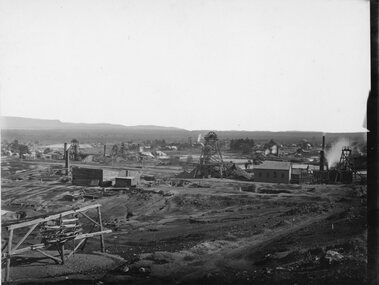 Stawell Historical Society Inc
Photograph, Panorama of Stawell Township taken from Big Hill c1905 -- 4 Photos
Panorama of Stawell Township c1910 Taken from Big Hill. Three original images in Photo Cabinet 3.stawell mining -
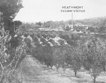 Ringwood and District Historical Society
Photograph, View of what was Heathmont township taken from about Royal Avenue looking at Mr. Herman Pump's orchard. Old bridge over Canterbury Road can be seen on left
Typed below photograph, "View of what was Heathmont township taken from about Royal Avenue looking at Mr. Herman Pump's orchard. Old bridge over Canterbury Road can be seen on left." -
 City of Kingston
Pamphlet - Colour, Brock Bros, South Brighton Township Estate, 1888
Sales plan for land in the suburb of South Brighton (Moorabbin), bounded by Point Nepean Road, South Road, Patterson Street and the Mordialloc Railway Line. Incorporates Wolsely Street and Gordon StreetThe developing urban area of Moorabbin within the City of Kingston. This land sale pamphlet illustrates the subdivision of land within the municipality and the changing demographic of the district as new houses are constructed close to infrastructure.Colour pamphlet advertising for private sale the South Brighton Township Estate, South Brighton. Incorporates a map of the estate bordered by Point Nepean Road, South Road, Patterson Street, and the Mordialloc Railway Line. Includes Wolsley Street and Gordon Street. land sales, south brighton, estate, moorabbin -
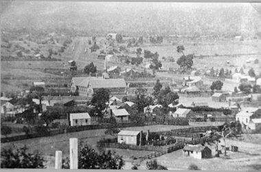
 Clunes Museum
Photograph, 1865
VIEW IN TOWNSHIP CLUNES, SOUTH EAST. PERIOD 1865. TAKEN FROM HILLSIDE BELOW CAMP PARADE, VICINITY MR. SWANTON'S HOUSE PHOTOGRAPH OF TOWNSHIP OF CLUNES, SOUTH EAST .1 SEPIA PHOTOGRAPH MOUNTED ON CARDBOARD. .2 BLACK AND WHITE PRINT .3 SEPIA PHOTO PRINT .4 BLACK AND WHITE PHOTO PRINT .5 BLACK AND WHITE PHOTO PRINT HOUSES SURROUNDED BY PICKET FENCES, POPPET LEGS AND CHIMNEY STACK.VIEW IN TOWNSHIP CLUNES. SOUTH EAST.local history, photography, photographs, clunes township -
 Stawell Historical Society Inc
Photograph, Stawell Township looking towards Sister Rocks which includes Stawell East School 1880 -- later becoming Stawell High School
Stawell Township - includes Stawell East School 1880. Later Stawell High School. Looking towards Sister Rocks.stawell -
 Stawell Historical Society Inc
Photograph, Great Western Township looking North from Paxton Street c1890's
Great Western Township c1890's looking North from Paxton Street. Original Hotel. Store. Salinger's and Cottages.stawell -
Clunes Museum
Map
MAP DATED JULY 21ST,1873MAP OF CLUNES WATER SUPPLY, TOWNSHIP OF CLUNES, SHOWING SYSTEM OF DISTRIBUTION.TOWNSHIP OF CLUNESlocal history, document, maps, clunes water -
Whitehorse Historical Society Inc.
Map, Township of Norwich, ca 1850
Plan of the Township of Norwich being subdivision of Section III, Parish of Nunawading, County of Bourke, consisting of suburban farms, vineyard sites and town lots, for sale by auction by W. Casey & Co. [c. 1850]. Original in Vale Maps Collection, La Trobe Library.norwich village, vermont, parish of nunawading, vermont south, maps -
Lakes Entrance Historical Society
Book, Stevens M I, Township of Cann River, Parish of Noorinbee, County of Croajingolong, 1977
An account of the development of the Cann River town and district in Gippsland, Victoria, compiled for the 50th. anniversary of the Cann River school. Includes list of pupils and head teachers, information on other schools, and recollections of residents.settlers, schools, township -
Clunes Museum
Photograph - PHOTOGRAPHS, VIEW IN TOWNSHIP, CLUNES, SOUTH EAST
Five reproduced black and white images of Clunes and surrounds; Camp Parade, Clunes South West View in Township, Clunes South East Port Phillip and Colonial Goldmining Company Victoria Quartz Mining Company Registered, Clunes Criterion Quartz Mining Company Registered Clunes clunes township, clunes mines -
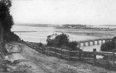 Lakes Entrance Historical Society
Postcard - Cunninghame township, Lakes Entrance Victoria c1905, 1905c
Also Black and white copy 12.5x20.5 Good condition P01146.1Black and white postcard of Cunninghame township, mud flats, North Arm Bridge, wooden bridge to mud island in North Arm, post and rail fence, beside main road. Road appears to have a sand surface. Bicycle leaning against fence. Lakes Entrance Victoriabridges, fences, topography, roads and streets -
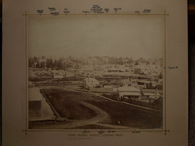 Clunes Museum
Photograph, BEAUCHAMP PHOTOGRAPHY, CLUNES TOWNSHIP, CIRCA 1870
PHOTOGRAPH OF CLUNES TOWNSHIP LOOKING WEST TAKEN FROM MRS.GREENWOODS HOME IN GEORGE STREET, CLUNES. BUILDINGS SHOWN INCLUDE JAMES MOLONEY AND CRITERION HOUSE. .1 SEPIA PHOTOGRAPH MOUNTED WITH POINTS OF INTEREST NOTED AROUND THE BORDER OF THE PHOTOGRAPH .2 LARGER SEPIA PHOTOGRAPH MOUNTEDFROM GEORGE STREET, LOOKING WESTlocal history, photography, clunes township -
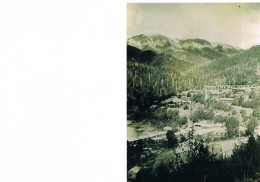 Kiewa Valley Historical Society
Photograph Bogong Township, Bogong Township Circa 1940s right side view, circa 1950
The Bogong Township (circa 1930s) was constructed by The State Electricity Commission of Victoria as a base camp for construction workers under the Kiewa Hydroelectric Scheme starting in 1938. The Scheme employed 4000 men during its construction phase. A small number were first housed at Bogong Village and when required the Mount Beauty Township was established(1949). Construction at the dams and Power Stations was interrupted during World War II. June 1951 started construction at full pace. The Bogong Township was developed firstly as an accommodation centre (base camp) for construction workers employed under the Kiewa Hydroelectric Scheme. Due to the influx of European workers into the Township the beautification of the immediate surrounds(gardens etc.) had a distinct European flavour. This environment has been very beneficial for tourism in later years. Strict environmental control has not allowed for any extensive redevelopment in tourist accommodation and basically restricted it to the accommodation initially built for the construction workers. Activities such a bike riding, snow skiing, restricted horse riding and bush walking on the Alpine plains and mountains are now a viable part of the Kiewa Valley Tourist Industry.Scanned copy of original black and white photo. Paper manufacturer is Kodak. Paper is Kodak XtraLife II.On reverse side "Kodak ExtaLife II paper"bogong village, bogong township, sec alpine constructions, victorian alpine tourism, winter sports. -
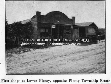 Eltham District Historical Society Inc
Negative - Photograph, Coghill & Haughton, First shops at Lower Plenty opposite Plenty Township Estate, c.1924
Negative copy and associated print of detail from original Sales Brochure: Plenty Township Estate and Bryn Teg Hill's Estate, Coghill & Haughton, Melbourne (c.1924)Roll of 35mm Black and White negative film, 3 strips, (1 of 14 frames) Print 10 x 15 cmFilm - Agfa Ortho 25lower plenty, bryn teg hill's estate, coghill & haughton, sales brochure, main road, plenty-township-estate, shops -
 Eltham District Historical Society Inc
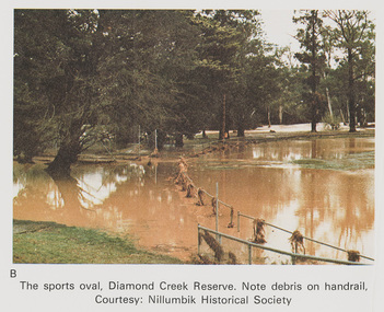
Work on paper (Sub-Item) - Photograph, The Sports Oval, Diamond Creek Reserve, Diamond Creek Township, 8 April 1977
Colour photograph. Note debris on the rail fencing around the oval. The Diamond Creek in flood at Diamond Creek township, 8 April 1977 Nillumbik Historical Society collectionflood, diamond creek, flooding, oval, nillumbik historical society, rail