Showing 1049 items matching "trail"
-
 Eltham District Historical Society Inc
Photograph - Digital Photograph, Alan King, Sign: Clara Southern, Heidelberg School Artists Trail, Main Road, Research, 2008
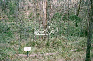
Warrandyte artist, Clara Southern, features on the Artists Trail. Published: Nillumbik Now and Then / Marguerite Marshall 2008; photographs Alan King with Marguerite Marshall.; p189 Since early in the 20th century this district has attracted artists and other creative people. So much so, that Eltham has been compared to the Left Bank in Paris, New York’s Greenwich Village and London’s Bloomsbury. That is until the 1970s when Eltham rapidly expanded into a suburb. However many artists still flourish not only in Montsalvat, Dunmoochin and the Bend of Islands but elsewhere in Nillumbik. Some artists who have worked or lived in Nillumbik are well-known nationally and internationally. Artists are attracted to the hilly district’s subtle colours, unique light and the Yarra River and Diamond Creek. The railway’s extension to Eltham in 1902 brought artists to paint for the day or to camp. Then many settled in Eltham, perhaps also because the poor quality land, far from the city, was cheap. Following World War Two they found they could build houses and studios cheaply by making their own mud-bricks. The flexible material, with its warm tones blending into the bush, also satisfied their aesthetic sensibilities. As early as 1900, Will Longstaff, known for his painting The Ghosts of Menin Gate at the National War Memorial in Canberra, lived at Stanhope in Peter Street, Eltham, later to become the home of intellectuals Clem and Nina Christensen. Members of Australia’s first significant art movement, the Heidelberg School of Artists, painted in Eltham, Warrandyte and Diamond Creek. Walter Withers lived at the corner of Bolton and Brougham Street, Eltham and taught Sir Hans Heysen, who for a short while stayed with the Withers family. In Warrandyte were Clara Southern, whom Frederick McCubbin taught at the National Gallery School and Penleigh Boyd, who is represented in all Australian state galleries and the National Collection in Canberra. May Vale, daughter of politician William, lived in Diamond Creek. With Jane Price they feature on the Heidelberg School Artists Trail, part of which runs through Nillumbik. The trail includes signs each displaying a reproduction of a painting by an artist and located near where the artist lived or painted. In Nillumbik the trail includes parts of Warrandyte, Eltham in the Alistair Knox Park, Main Road shopping precinct and Wingrove Park, the Research walking track on Main Road and the Diamond Creek Reserve. In 1916 artist William ‘Jock’ Frater lived at the corner of Arthur and Bible Streets, Eltham. Before then, Frater, with other artists including Percy Leason (who moved to Eltham in the mid 1920s) painted in Eltham on weekends. They camped near Bible and Pitt Streets and along the Diamond Creek where the Eltham Retirement Centre now stands.4 In 1921, painter Peter Newbury (father to painter David Newbury, who was born in Eltham) moved to Cromwell Street, Eltham. Max Meldrum, the first Australian painter to formulate a consistent theory of art largely based on tone,5 taught local artists Alan Martin, Clarice Beckett, Peter Glass and Justus Jörgensen. Meldrum visited Eltham then rented a house there for 18 months opposite Wingrove Park. In 1934, artist and architect Justus Jörgensen and his doctor wife Lil and friends built Montsalvat, the artists’ colony. Montsalvat has played an important part in attracting artists to Eltham and its mud-brick, pisé, stone and recycled building materials has had a major influence on Eltham’s built environment. Jörgensen’s students who also helped him build Monstalvat included Arthur Munday, Lesley Sinclair, Helen Lempriere, Joe Hannan, Helen, Sonia and jeweller/sculptor, Matcham Skipper. Among artists who visited Montsalvat were Clifton Pugh and Angry Penguins’ artists Albert Tucker and Arthur Boyd. Some who painted after World War Two were Alan Martin of Eltham and Warrandyte artists Frank Crozier and Harry De Hartog6, one of Melbourne’s first painters influenced by Cubism.This collection of almost 130 photos about places and people within the Shire of Nillumbik, an urban and rural municipality in Melbourne's north, contributes to an understanding of the history of the Shire. Published in 2008 immediately prior to the Black Saturday bushfires of February 7, 2009, it documents sites that were impacted, and in some cases destroyed by the fires. It includes photographs taken especially for the publication, creating a unique time capsule representing the Shire in the early 21st century. It remains the most recent comprehenesive publication devoted to the Shire's history connecting local residents to the past. nillumbik now and then (marshall-king) collection, clara southern, main road, research (vic), heidelberg school artists trail -
 Eltham District Historical Society Inc
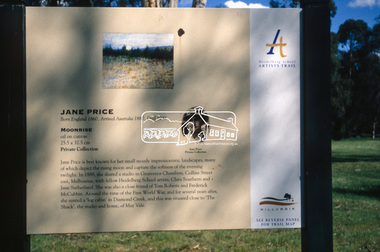
Slide - Photograph, Moonrise, Jane Price, Heidelberg School Artists Trail, Diamond Creek, c.Nov. 2001
The Heidelberg School Artists' Trail extends from Heidelberg through Eltham and Warrandyte and to the Dandenongs. It features signs depicting paintings of artists in the location in which they were painted. Transcription of sign: Jane Price is best known for her small moody impressionistic landscapes, many of which depict the rising moon and capture the softness of the evening twilight. In 1889, she shared a studio in Grosvenor Chambers, Collins Street east, Melbourne, with fellow Heidelberg School artists, Clara Southern and Jane Sutherland. She was also a close friend of Tom Roberts and Frederick McCubbin. Around the time of the First World War, and for several years after, she rented a ‘log cabin’ in Diamond Creek, and this was situated close to ‘The Shack’, the studio and home, of May Vale. Part of a slide show presentation "A Trip Down the Diamond Creek" by Russell Yeoman to the Eltham District Historical Society meeting of 14 Nov. 200135mm colour positive transparency Mount - Black and Whiteart in public places, diamond creek, heidelberg school artists trail, jane price, moonrise, public art, sign -
 Eltham District Historical Society Inc
Slide - Photograph, On the Eltham Road, Walter Withers (1906), Heidelberg School Artists Trail, Alistair Knox Park, Eltham, c.Nov. 2001
The Heidelberg School Artists Trail was established in about 1999 with about 52 signs across four local governemnt areas including Nillumbik and Banyule. It extends from Heidelberg through Eltham and Warrandyte and to the Dandenongs. It features signs depicting paintings of artists in the location in which they were painted. This one acknowledges "On the Eltham Road", 1906. Transcription of the text states: "In this cheerful rural landscape, Walter Withers has captured the spirit of early Eltham. Eltham was a quiet, sleepy village, where geese wandered up the main Road and the locals either walked or rode their horses or bicycles around the township. Walter Withers was known to load up his bicycle with his collapsible easel, folding stool, paint box, water bottle and canvases, and would head off for a day’s painting. He was also known for his walking, as was his family, and they became known as the ‘Walking Withers’ Part of a slide show presentation "A Trip Down the Diamond Creek" by Russell Yeoman to the Eltham District Historical Society meeting of 14 Nov. 200135mm colour positive transparency Mount - Black and Whiteeltham, alistair knox park, heidelberg school artists trail, on the eltham road, public art, sign, walter withers -
 Marysville & District Historical Society
Map (Item) - Walking map, Department of Sustainability and Environment, marysville TRAILS, 07-2011
A map showing all the walking trails in and around Marysville and the district. This map was produced by the Department of Sustainability and Environment in July 2011.A map showing all the walking trails in and around Marysville and the district.ISBN 978-1-74287-122-6 (print)marysville, victoria, australia, marysville trails, department of sustainability and environment, parks victoria, steavenson falls trail, beauty spot trail, gilberts gully trail, tree fern gully trail, michaeldene trail, wilks creek trail, keppel lookout trail, lady talbot drive, taggerty cascades, the beeches, keppel falls, phantom falls, cathedral range state park, cambarville, lake mountain trails, cumberland falls, mystic mountains tourism -
 Marysville & District Historical Society
Map (Item) - Tourist and business map, Narbethong Community and Tourism Group, Narbethong Buxton Taggerty Tourist and Business Map, 04-2008
A tourist and business map of Narbethong, Buxton and Taggerty. This map was produced by the Narbethong Community and Tourism Group in April 2008. It was produced to promote the natural attractions, adventure activities and food trail from the Black Spur, through Narbethong, Buxton and Taggerty.A tourist and business map of Narbethong, Buxton and Taggerty.This publication has been produced by the Narbethong Community and Tourism/ Group (NCTG) to promote the natural attractions, adventure activities and food/ trail from the Black Spur, through Narbethong, Buxton and Taggerty./ the information provided in this publication has been supplied by the individual/ members. NCTG takes no responsibility for its accuracy./ April 2008narbethong, buxton, taggerty, victoria, australia, tourist and business map, narbethong community and tourism group, acheron valley, yarra track, wood's point, black spur, mystic mountains, the meeting of the waters, cathedral range, danico design counted cross stitch, things of sand & stone, buxton zoo nursery & oddz & enz, willowbank at taggerty, safe trek 4wd services, pnl 4wdriving, buxton trout and salmon farm, mystic mountains ski hire & outdoors, narbethong ski hire, highwood health centre, cathedral view natural therapies, narby cabinets, plants by shelian, gb timber, executive signs, rb automotive repairs, buxton car care, marysville towing & equipment hire, martyn slade building design, cathedral peak framing, black spur roadhouse & ski hire, tudor lodge roadhouse & ski hire, buxton roadhouse & persian bazzar, buxton post office general store & niche bar, igloo roadhouse, taggerty store, narby eggs, marapana agistment park, mantirri blueberry farm, carmyle farm, hazelwood hazelnuts, south cathedral lavender farm, cathedral cherries, black spur motel & caravan park, woodlands rainforest retreat, chestnut glade, black spur inn, wombat cottage, abbey lake luxury b & b spa cottages, blue views holiday cottages, camp narbethong, marapana farm stay b & b, mantirri blueberry farm b & b, little dene garden cottages, silverstream b & b cottages, nareen cabins, moondai farm b & b, south cathedral farm luxury b & b cottages, yarrolyn caravan park, sarsens rest, lomah retreat, pinjarra gardens, kingbilli country estate, henry viii manor house, buxton hotel, butters cafe of buxton, wagtail wines, little river wines, lanterns at willowbank, wirrawilla rainforest walk, wilhemina falls, the cascades -
 Eltham District Historical Society Inc
Photograph (Item) - Negative, Fred Mitchell, Autumn, Wingrove Park Trail, 1988
Fred Mitchell 1988 Entrant No. 5 Ref: Series 34, Items 3, 4, 46-49 The images in this record were not selected for inclusion. SHIRE OF ELTHAM COMMUNITY PHOTOGRAPHIC SURVEY Photography is an artform which many of us practice, sometimes purely for artistic pursuit, sometimes to record the people and events in our lives. In 1988, as part of a local Bicentennial project, the Shire of Eltham conducted the Eltham Community Photographic Survey. Up to 100 entries were to be selected by a panel of photographers for entry into the Eltham Photographic Survey Exhibition. Entries had to be submitted by May 13, 1988. Entrants whose images were selected for the exhibition were contacted and requested to further submit an entry form providing entrant’s name, area of residence, age, and proposed captions. These details were then used to produce labels for the exhibition mounts. Where negatives had not been supplied, these were requested to support the display of printed enlargements mounted on 10” x 8” cardboard. The mounted prints were made available post exhibition for sale at $8.50 each for colour prints and $7.00 for B&W prints. Residents in the Shire were invited to collect a free roll of film and take a photograph of what they either liked or did not like about the area. A total of 160 entrants submitted multiple entries for the exhibition. Of those selected for exhibition, entrants ranged in age from 9 to 70 years. All custom colour and black and white printing for the exhibition was completed by Wattle Studios of Eltham. The Eltham Photographic Survey was jointly auspiced by the Shire of Eltham and Wattle Studios, of 953 Main Road, Eltham. The project was greatly assisted by: • David McRitchie, Media Studies Lecturer Victoria College, Rusden Campus. • Ian and Annette Toohill of Wattle Studios • Tracy Naughton, Eltham Community Arts Officer • Neville Emerson Pty. Ltd. • Superior Press, Eltham • Kodak Australasia Pty. Ltd. • Agfa Gevaert Ltd. • Townsend Colourtech Pty. Ltd. • The Australian Bicentennial Authority • Eleanor Bowers, Secretary, Eltham Arts Council The exhibition was placed on display in the Woolworths Arcade, Eltham between Monday June 6th and Saturday June 11, 1988. It was also intended to hold the exhibition at a venue in the Shire’s North Riding from Monday, June 20 to Friday June 24. It was then displayed at the Were Street Theatre, Montmorency from Friday, June 24 to Thursday, July 7. Series 34: Eltham Community Photographic Survey 1988 - Prints & Documentation Series consists of 117 photographs of Shire scenes taken by members of the community. Items I - 41 are larger photographs mounted on card, which were exhibited. Items 42 - 117 are unmounted copies, alternative takes and other entries. Corresponding negatives contained in Series 35: Eltham Community Photographic Survey 1988 – Negatives which consists of 267 colour and B&W negatives and one colour slide of Shire scenes taken by members of the community. The negatives are arranged by the entrant number of the photographer. The Eltham Community Photographic Survey collection is significant to the local community as it was curated by the local community - ordinary people of all ages - representing what they liked and did not like in the area where they lived. It represents an unfiltered representation of the Shire of Eltham as it was in 1988. It also represents one of many projects as part of the national programme of events and celebrations to commemorate the bicentenary. It is a time capsule of life in the 1980s of this urban and rural municipality in Melbourne's north. shire of eltham archives, bicentennial project, eltham, eltham community photographic survey, series 35, film - kodak ga 100 5095, fred mitchell, scan - 35mm negative, wingrove park trail -
 Eltham District Historical Society Inc
Photograph, Significant Eucalyptus tree, Diamond Creek Trail, Alistair Knox Park, Eltham, c.1985
alistair knox park, diamond creek trail, significant tree -
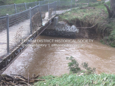
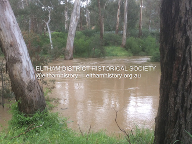 Eltham District Historical Society Inc
Photograph - Digital Photograph, Carlota Quinlan, Diamond Creek in flood, Diamond Creek Trail, Eltham South, 16 Oct 2021
diamond creek (creek), diamond creek trail, eltham south, flooding, floods, floodwater -
 Eltham District Historical Society Inc
Photograph - Digital Photograph, Carlota Quinlan, Diamond Creek in flood, Diamond Creek Trail, Eltham South, 16 Oct 2021
diamond creek (creek), diamond creek trail, eltham south, flooding, floods, floodwater -
 Eltham District Historical Society Inc
Photograph - Digital Photograph, Carlota Quinlan, Diamond Creek in flood, Diamond Creek Trail, Eltham South, 16 Oct 2021
diamond creek (creek), diamond creek trail, eltham south, flooding, floods, floodwater -
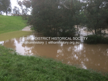
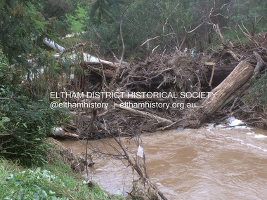
 Eltham District Historical Society Inc
Photograph - Digital Photograph, Carlota Quinlan, Diamond Creek in flood, Diamond Creek Trail, Eltham South, 17 Oct 2021
diamond creek (creek), diamond creek trail, eltham south, flooding, floods, floodwater -
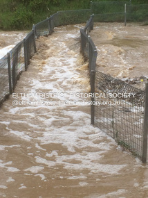
 Eltham District Historical Society Inc
Photograph - Digital Photograph, Carlota Quinlan, Diamond Creek in flood, Diamond Creek Trail, Eltham South, 17 Oct 2021
diamond creek (creek), diamond creek trail, eltham south, flooding, floods, floodwater -
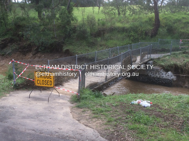
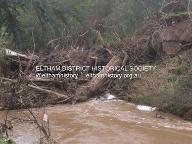
 Eltham District Historical Society Inc
Photograph - Digital Photograph, Carlota Quinlan, Diamond Creek in flood, Diamond Creek Trail, Eltham South, 17 Oct 2021
diamond creek (creek), diamond creek trail, eltham south, flooding, floods, floodwater -
 Eltham District Historical Society Inc
Photograph - Digital Photograph, Carlota Quinlan, Diamond Creek in flood, Diamond Creek Trail, Eltham South, 17 Oct 2021
diamond creek (creek), diamond creek trail, eltham south, flooding, floods, floodwater -
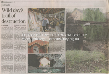 Eltham District Historical Society Inc
Newsclipping, Reid Sexton, Wild day's trail of destruction, The Age, Tuesday, December 27, pp4-5, 2011
A late afternoon storm on Christmas Day 2011. A flash flood occurred from significant rain fall and hail, which accumulated along an old waterway with floodwater submerging cars along Valonia Drive then down Grove Street flooding houses, through the Bible Street Reserve where it then submerged Main Road washing away the small railway trestle bridge opposite the reserve then flooding the Judge Book Village before finally entering the Diamond Creek. Widespread damage occured from hail and flash flooding.fay bridge collection, eltham, 2011-12-27, flood damage, floods, floodwater -
 Eltham District Historical Society Inc
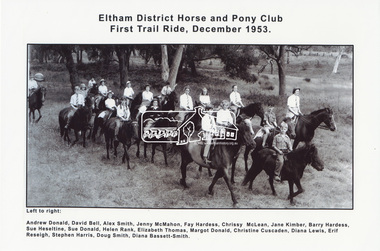
Photograph, Eltham District Horse and Pony Club, First Trail Ride, December 1953, Dec 1953
The Pony Club was a dream of Diana Bassett-Smith, which came true, based on the British Horse Society Pony Club formed in 1929; a worldwide organisation. A meeting was called at ‘Lavender Park’, the home of Mrs Mary Grant and her brother George ‘Mel’ Balfour. Invited to the meeting were Baye Skues, Eric Rundle, Ben Taylor, the Barringtons, Smiths, Lou Lewis and Gwen Cascaden. They all supported Diana Bassett-Smith for forming a Pony Club. The first formal meeting was held at ‘Landscape’, which was the home of the Barringtons and the former home of artist Percy Leason. Negotiations with the Lands Department resulted in the club being granted use of the grounds in Eltham Lower Park for a peppercorn rent. Eltham was the 4th Pony Club in Victoria; the other three being Frankston, Templestowe and Western District. Together they formed the Pony Club Association of Victoria at Diana Bassett-Smith’s instigation. This image shows club members attending their first rally held in the summer school holidays, December 1953 L-R: Andrew Donald, Alex Smith, Jenny McMahon, David Bell, Fay Hardess, Chrissy Mclean, Jane Kimber, Barry Hardess, Sue Heseltine, Sue Donald, Helen Rank, Elizabeth Thomas, Margot Donald, Christine Cuscaden, Diana Lewis, Erif Reseigh, Stephen Harris, Diana Bassett-Smith Black and white photographic reprint with names printed on frontalex smith, andrew donald, barry hardess, chrissy mclean, christine cuscaden, david bell, diana bassett-smith, diana lewis, elizabeth thomas, eltham district horse and pony club, erif reseigh, fay hardess, helen rank, jane kimber, jenny mcmahon, margot donald, stephen harris, sue donald, sue heseltine -
 Eltham District Historical Society Inc
Slide - Photograph, Batman Apple tree (Malus pumila), Plenty RIver Walking Trail, Corowa Crescent, Greensborough, c.2004
Part of a presentation on "Significant Trees, Wildflowers and Local Gardens" by Russell Yeoman to the 10 November 2004 Eltham District Historical Society meeting35mm colour positive transparency Mount - white 7 dots (Technodia Italy)batman apple tree, corowa crescent, greensborough, malus pumila, plenty river walking trail, significant tree -
 Eltham District Historical Society Inc
Slide - Photograph, Smiths Gully to St Andrews, Nature History Trail, c.2004
Situated opposite Queenstown Cemetery35mm colour positive transparency Mount - white 7 dots (Technodia Italy)smiths gully road, st andrews, nature history trail, smiths gully -
 Eltham District Historical Society Inc
Slide - Photograph, Smiths Gully to St Andrews, Nature History Trail, c.2004
Situated opposite Queenstown Cemetery35mm colour positive transparency Mount - white 7 dots (Technodia Italy)smiths gully road, st andrews, nature history trail, smiths gully -
 Eltham District Historical Society Inc
Slide - Photograph, Smiths Gully to St Andrews, Nature History Trail, c.2004
Situated opposite Queenstown Cemetery35mm colour positive transparency Mount - white 7 dots (Technodia Italy)smiths gully road, st andrews, nature history trail, smiths gully -
 Eltham District Historical Society Inc
Slide - Photograph, Smiths Gully to St Andrews, Nature History Trail, c.2004
Situated opposite Queenstown Cemetery35mm colour positive transparency Mount - white 7 dots (Technodia Italy)smiths gully road, st andrews, nature history trail, smiths gully -
 Eltham District Historical Society Inc
Slide - Photograph, Smiths Gully to St Andrews, Nature History Trail, c.2004
Situated opposite Queenstown Cemetery35mm colour positive transparency Mount - white 7 dots (Technodia Italy)smiths gully road, st andrews, nature history trail, smiths gully -
 Eltham District Historical Society Inc
Slide - Photograph, Smiths Gully to St Andrews, Nature History Trail, c.2004
Situated opposite Queenstown Cemetery35mm colour positive transparency Mount - white 7 dots (Technodia Italy)smiths gully road, st andrews, nature history trail, smiths gully -
 Eltham District Historical Society Inc
Slide - Photograph, Smiths Gully to St Andrews, Nature History Trail, c.2004
Situated opposite Queenstown Cemetery35mm colour positive transparency Mount - white 7 dots (Technodia Italy)smiths gully road, st andrews, nature history trail, smiths gully -
 Eltham District Historical Society Inc
Slide - Photograph, Smiths Gully to St Andrews, Nature History Trail, c.2004
Situated opposite Queenstown Cemetery35mm colour positive transparency Mount - white 7 dots (Technodia Italy)smiths gully road, st andrews, nature history trail, smiths gully -
 Eltham District Historical Society Inc
Slide - Photograph, Smiths Gully to St Andrews, Nature History Trail, c.2004
Situated opposite Queenstown Cemetery35mm colour positive transparency Mount - white 7 dots (Technodia Italy)smiths gully road, st andrews, nature history trail, smiths gully -
 Eltham District Historical Society Inc
Slide - Photograph, Smiths Gully to St Andrews, Nature History Trail, c.2004
Situated opposite Queenstown Cemetery35mm colour positive transparency Mount - white 7 dots (Technodia Italy)smiths gully road, st andrews, nature history trail, smiths gully