Showing 1046 items
matching trails
-
 Queenscliffe Maritime Museum
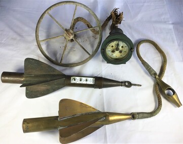
Instrument - Trailing Ship's Log
Used to 1935 by John Gordon Hanby while in the militia at Fort Queenscliffe.Metal trailing log comprising of a gauge and two rotors towed behind ships to measure distance.Walker's, Cherve, Mark III.towing log, measuring distance, ship's log -
 Melton City Libraries
Pamphlet, Dry Stone Wall Driving Trail, Unknown
"The dry stone walls provide a tangible link to the area’s white settlement, and they remain a symbol of the profound change in land usage from the original Kulin custodians to the European arrivals of the nineteenth century. The bulk of dry stone wall construction in Victoria occurred between the 1850s and 1880s. The gold rush of the early 1850s in particular inspired a flurry of construction. At this time, labour previously available for shepherding livestock dried up, as men gravitated to the goldfields to seek their fortunes. This necessitated the building of fencing to contain the district’s growing number of sheep, cattle and horses. An explosion in surveying, subdivision and the sale of Crown lands also contributed to a boost in construction. Government regulations that punished pastoralists for allowing their livestock to stray provided further incentive to fence-off previously open expanses of land. The major benefit of this type of fencing was that it utilised the materials at hand; the plentiful grey basalt that scattered the landscape. In the case of the dry stone walls built around Melton, the characteristic round or oval shape of the volcanic fieldstones on the western plains inspired some distinctive designs.54 Another advantage of dry stone walls was their ability to withstand the ravages of flood, fire and drought often experienced in the district. This durability accounts for the fact that many of these fences still exist today". Dry Stone Wall trail brochure/pamphlet for visitors provided by Melton Visitor Information Centrecouncil, landscapes of significance -
 Canterbury History Group
Pamphlet - Heritage Trail official opening 2 March 2006, 2/03/2006
Leaflet/ invitation for the officail opening of the Heritage Trail at the Canterbury Primary School 2 March 2006canterbury, canterbury primary school, molesworth street, wurundjeri land, primary schools -
Lakes Entrance Historical Society
Book, Drew G J, Discovering Historic Burra, 1998
A description of the historic copper mining area of Burra, South Australia with maps tourist trail photographs.historic sites, township, mines and mining -
 Eltham District Historical Society Inc
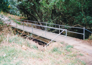
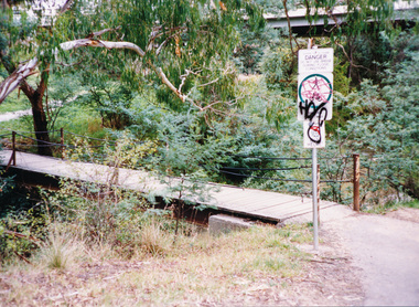
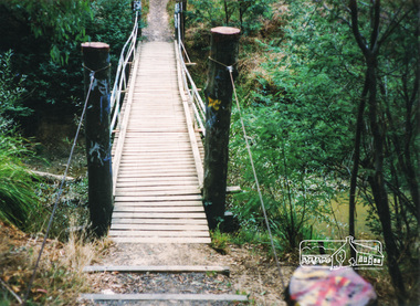
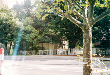
Photograph, Doug Orford, Diamond Creek Trail, Eltham
Two colour photographs showing view looking towards and entering footbridge on the Diamond Creek Trail, Elthamwalkways, bridges, diamond creek, eltham, alistair knox park -
 Eltham District Historical Society Inc
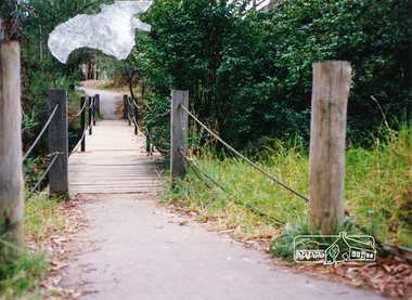
Photograph, Doug Orford, Diamond Creek Trail, Eltham
Two colour photographs showing view looking towards and entering footbridge on the Diamond Creek Trail, Elthamwalkways, bridges, diamond creek, eltham -
 Eltham District Historical Society Inc
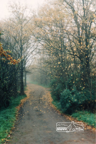
Photograph, Diamond Creek Trail, Eltham
Colour photograph of Autumn view of Diamond Creek Trail opposite Dalton Street west of Main Roaddalton street, walkways -
 Eltham District Historical Society Inc
Photograph, Doug Orford, Diamond Creek Trail, Eltham
Two colour photographs showing view looking towards and entering footbridge on the Diamond Creek Trail, Elthamwalkways, bridges, diamond creek, eltham, alistair knox park -
 Eltham District Historical Society Inc
Photograph, Doug Orford, Diamond Creek Trail, Eltham
Two colour photographs showing view looking towards and entering footbridge on the Diamond Creek Trail, Elthamwalkways, bridges, diamond creek, eltham -
 Bendigo Historical Society Inc.
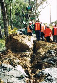
Photograph - CASTLEMAINE GAS COMPANY COLLECTION: PHOTO BENDIGO, 23/09/1996
Bendigo plough trail 23/08/1996. Several people looking at the track being dug by plough.Fujiorganisation, industry, gas and fuel -
 Bendigo Historical Society Inc.
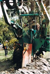
Photograph - CASTLEMAINE GAS COMPANY COLLECTION: PHOTO BENDIGO, 23/08/1996
Bendigo plough trail 23/08/1996. Tractor with plough digging track 2 workers nearbyFujiorganisation, industry, gas and fuel -
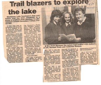 Whitehorse Historical Society Inc.
Document, Trail blazers to explore the lake, 24/07/1987 12:00:00 AM
Nunawading Gazette 24 July 1987 on school project for Blackburn LakeArticle from Nunawading Gazette 24 July 1987 on school project for Blackburn Lake Nature Trail.Nunawading Gazette 24 July 1987 on school project for Blackburn Lake blackburn lake sanctuary, emmaus college, alvin, elaine, neale, rachel, holmes, catherine -
 Wangaratta RSL Sub Branch
Map - Framed Map
Large brown timber framed black and white map with dotted lines arrows and circles.The Kokoda Trail First Half Kokoda to Efogi Second Half Efogi to Owers Cornerkokoda trail, papua new guinea, world war 2 -
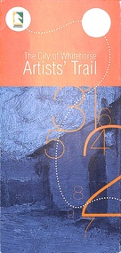 Ringwood and District Historical Society
Pamphlet - Brochure, Artist's Trail
Inspiration drawn from a brochure written by the Box Hill Historical Society Inc City of Whitehorse Artists Trail -
 Federation University Art Collection
Painting - Artwork, Lambeth, Paul, 'This is the Perpetual Journey' by Paul Lambeth, 2008
Paul LAMBETH (15 September 1957- ) Born Melbourne, Victoria This item is part of the Federation University Art Collection. The Art Collection features over 2000 works and was listed as a 'Ballarat Treasure' in 2007.Followed the Burke and Wills trail while undertaking a Masters of Arts Research, and returning to Ballarat with the beginnings of a body of work. art, artwork, paul lambeth, staffmember, available -
 Eltham District Historical Society Inc
Photograph, Bootmakers cottage, 701 Main Road Eltham
Colour photograph of Bootmakers cottage at 701 Main Road Eltham, adjacent to Diamond Creek Trail, opposite Dalton Street701 main road, eltham, main road, bootmakers cottage, white cloud cottage, jarrold cottage, dalton street -
Whitehorse Historical Society Inc.
Article, Bike Trail Date Pushed Back, 1/08/2014 12:00:00 AM
The completion of the bike trail from Box Hill to Ringwood has been delayed.The completion of the bike trail from Box Hill to Ringwood has been delayed due to the removal of the Blackburn level-crossing.The completion of the bike trail from Box Hill to Ringwood has been delayed. bicycle paths, level-crossing -
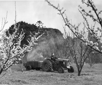 University of Melbourne, Burnley Campus Archives
Photograph - Black and white print, Information Branch Victorian Department of Agriculture, Student Spraying in the Orchard, c. 1967
Date estimated from Ref. No. Note by T.H. Kneen 4 March 1992, "Ferguson tractor drawing modern (Auto) mist spraying plant. Operator wearing protective clothing. The prominent tree on the left is Cupressus macrocarpa planted 1857. Note also emergent Araucaria spp."Black and white photograph. Student driving a tractor in the Orchard in Spring. Automatic spraying machine on a trailor. Student wearing protective gear.On reverse, "Photograph by Information Branch Victorian Department Of Agriculture Ref. No. D1101 F."ferguson tractor, mist spraying plant, machine operator, protective clothing, cupressus macrocarpa, araucaria spp., student working outside, orchard, auto mist spraying plant, tractor, publicity -
 Bendigo Historical Society Inc.
Map - LONG GULLY HISTORY GROUP COLLECTION: MAP - EAGLEHAWK ROAD
BHS CollectionMap of part of Eaglehawk Road showing a Bike Ride Trail. Map is dated September 01, 1998, Scale 1:5000.bendigo, history, long gully history group, the long gully history group - map - eaglehawk road, natural resources and environment, bike ride trail -
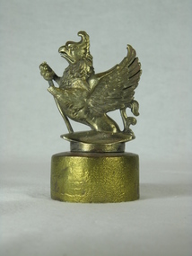 Gippsland Vehicle Collection
Radiator Cap, Early 20th century
Radiator cap from a 1914 Wolseley owned by Maffra architect Steven Ashton and featured in a photo of Maffra Post Office and Court House, just prior to the Great War, held by the East Gippsland Historical Society.Solid brass, screw-on radiator cap with Vauxhall Griffion emblem attached. Griffion missing end of left front leg.Inscribed "REG No 729889" under leading edge and "JOSEPH FRAY LTD, BIRMINGHAM" under trailing edge. 1914, maffra, ashton, wolseley, vauxhall, steven -
Lakes Entrance Historical Society
Book, Don Love, Steam & Motor Traders on the Gippsland Lakes, 2018
Comprehensive account of the trading boats which were powered by either stem or motor between 1858 to late 1980s on the Gippsland Lakes VictoriaThis book is dedicated to all those hardy mariners who blazed their trail across the waters of the Gippsland Lakesboats and boating, tourism, trades -
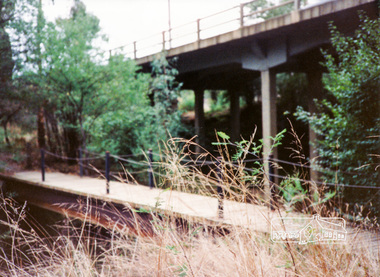 Eltham District Historical Society Inc
Photograph, Diamond Creek Trail bridge, Eltham South
Colour photograph of the Diamond Creek Trail bridge over the Diamond Creek near Eltham Lower Park; Main Road bridge in backgrounddiamond creek trail, bridges, eltham, main road -
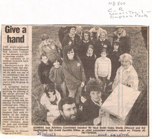 Whitehorse Historical Society Inc.
Newspaper - Article, Give a hand, 25/08/1993
Residents support sought by Somers Trail - Simpson Park advisory committee in the maintenance of the park, planting of native species and placement of nesting boxes.somers trail, simpson park advisory committee, smith, neal, zillwood, sheila, gillies, danielle, cooke, raylene, parks and reserves -
Lakes Entrance Historical Society
Book, LERHS, East Gippsland Rail Trail, 2015c
Display folder containing newspaper clippings leaflets and other information on the planning and completion of the East Gippsland rail trail. Lakes Entrance Victoriatransport, recreation -
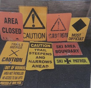 Falls Creek Historical Society
Sign - Falls Creek Ski Patrol
The first ski patroller in Falls Creek was Brian Caddy with two casual ski patrollers Rob Sarroff and David Crooke in the 1960s. In 1972 the “official” Falls Creek Ski Patrol was created under the advisement of Dr Rodney Moss with the support of the Management Committee. By 1977 there were six or seven patrollers, and currently there are around 40 patrollers on the team with 13-14 rostered on each day during peak season. In 1974 the Australian Ski Patrol Association (ASPA) was formed. On the 14th March 1975, the Falls Creek Tourist Area Management Committee applied for membership to ASPA. At that time, Falls Creek Ski Patrol was known as Falls Creek Ski Rescue. From that time, Falls Creek patrollers began wearing the recommended uniform of a white cross on a red parka.These signs are significant as they are representative of the work carried out by Falls Creek Ski Patrol to keep skiers safe.A variety of signs used by Falls Creek Ski Patrol to alert tourists to conditions on the mountains in the area.A range of words and symbols including:- AREA CLOSED CAUTION MOST DIFFICULT TRAILS MERGE - CAUTION CAUTION TRAIL STEEPENS AND NARROWS AHEAD SKI AREA BOUNDARY SKI PATROL OUT OF BOUNDS / AREA NOT PATROLLED / NO ACCESS TO SKI LIFTS / PROCEED AT OWN RISKfalls creek ski patrol, skiing safety -
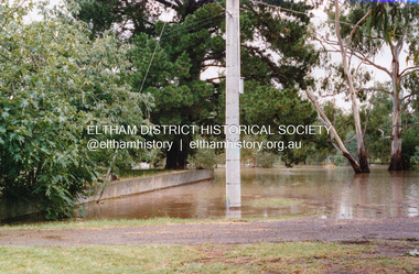
 Eltham District Historical Society Inc
Photograph, Floodwater, Diamond Creek, Eltham, Feb 2005, 2005
Three colour photographs of the Diamond Creek floodwater; two at Antoinette Blvd and one on the Diamond Creek Trail near Lower Park, Feb 2005eltham, main road, diamond creek, floods, diamond creek trail, antoinette boulevard -
 Eltham District Historical Society Inc
Photograph, Floodwater, Diamond Creek, Eltham, February 2005
Three colour photographs of the Diamond Creek floodwater; two at Antoinette Blvd and one on the Diamond Creek Trail near Lower Park, Feb 2005eltham, main road, diamond creek, floods, diamond creek trail, antoinette boulevard -
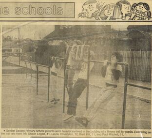 Bendigo Historical Society Inc.
Newspaper - GOLDEN SQUARE P.S. LAUREL ST. 1189 COLLECTION: NEWSPAPER CUTTINGS
Newspaper photo of Shaun Logan, Laurie Hovenden, Brett Hill and Paul Mitchell exercising on monkey bars. Parents built a fitness trail for the pupils.education, primary, golden square laurel st p.s., golden square primary school 1189 collection - newspaper cuttings, shaun logan, laurie hovenden, brett hill, paul mitchell -
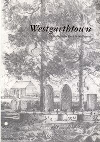 Bendigo Historical Society Inc.
Book - STRAUCH COLLECTION: WESTGARTHTOWN
BHS CollectionWhite 3 ring binder contains information on Westgarthtown,Tatura german heritage trail with illustrations, photographs and maps, mostly written in German language.victoria, history, german, history-victoria-german-westgarthtown-tatura -
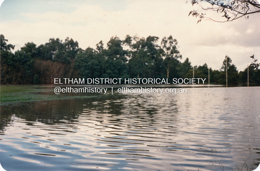 Eltham District Historical Society Inc
Photograph, Diamond Creek floodwater, Eltham
Four colour photographs of Diamond Creek floods in Susan Street and Dalton Street area. 1. Floodwater of Diamond Creek spreading towards Susan Street over the oval 2. Floodwater of Diamond Creek spreading towards Susan Street over the oval 3. Diamond Creek Trail from Dalton Street 4. Diamond Creek Trail from Dalton Streetdiamond creek, floods, etham, dalton street, susan street