Showing 672 items matching "tunnelling"
-
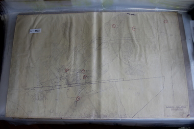 Coal Creek Community Park & Museum
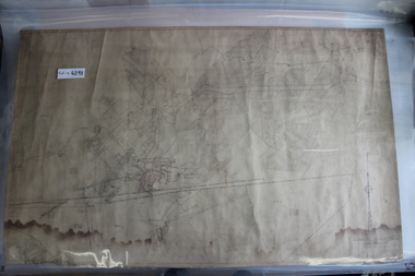
Mine Map, Amended 12/10/1949 Last visible date
8522.1 - Amended copy of object No. 6298, with red texta circles highlighting mine tunnel exits/entrances. -
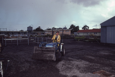 University of Melbourne, Burnley Campus Archives
Photograph - 35mm Colour slides, Construction Work, 1987
Construction work in the Nursery possibly a poly tunnel Aug and Sept 87. 12. "Orchids - Cymbios '74."construction, poly tunnel, nursery, students working outside -
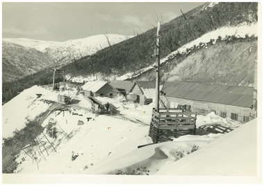 Falls Creek Historical Society
Photograph - No. 1 Headrace Tunnel, Kiewa Hydroelectric Scheme Workshops, 1952
MEYER COLLECTION - FALLS CREEK PHOTOS In 1947 a determined group of like-minded State Electricity Commission (SEC) staff including Ray Meyer, the chief surveyor of the Kiewa Hydro-Electric Scheme, had a common interest that revolved around the skiing potential of the snow-covered high plains which included what is now the resort of Falls Creek. The six SEC employees, Toni St Elmo, Ray Meyer, Jack Minogue, Lloyd Dunn, Adrian Ruffenacht and Dave Gibson (together with their families) banded together to secretly build a 'hut' that was the first ski lodge at Falls Creek. Using a road built in 1930s to gain access to Falls Creek, their hut project was carried out in secret as efforts by other skiers were blocked by H.H.C. Williams – the engineer in charge of the Hydro Scheme. In 1946 Ray Meyer made a trip to the Lands Office in Melbourne. He came away with a 99-year lease on three acres that was ideally suited for a hut designed by Lloyd Dunn. Adrian Ruffenacht (Design Engineer for the KHS) had suggested where the group should build because of easy access to a spring for water. Much of the building material required was scavenged from derelict huts on the high plains. Due to the need for secrecy, the determined group worked on the hut in the evenings and weekends to avoid detection. During the building period the group had met at Echidna Rock (now known as Eagle Rock) where Skippy St Elmo announced, "This is my favourite ‘Skyline’.” And so the first lodge in the area at Falls Creek Ski Resort came into existence. With the development of the International Poma in the 1970s, the Skyline Lodge, which was sited between the ski-lift’s pole one and pole two, was demolished. However, the legacy of Ray Meyer, Toni St Elmo, Jack Minogue, Lloyd Dunn, Adrian Ruffenacht and Dave Gibson and Skyline lives on in the vibrant atmosphere of Falls Creek Resort. The MEYER COLLECTION documents developments on the Kiewa Hydro Scheme and their life at Falls Creek from the mid 1930s to 1950s.This image is significant because it documents development of the Kiewa Hydroelectric Scheme.A black and white image of the No 1 Headrace Tunnel, Kiewa Hydroelectric Scheme showing workshops and the McKay Aditkiewa hydroelectric scheme, ray meyer -
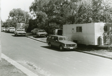 Ringwood and District Historical Society
Photographs, 1979-80 MMBW pipe line project at Hubbard Reserve, North Ringwood � cars and caravan of gang
Part of a 43-photo record of the MMBW�s engineering feat in drilling a 12 inch pipe line up to 40 feet deep through rock hardened by volcanic action associated with geological fault that occurs along the line. The work took place from October 1979 to May 1980 on the southern boundary of Hubbard Reserve, North Ringwood. The collection was presented to the Ringwood Historical Research Group by J Clarke on 9th June 1980.E561 N5 Feb 1980 A43 Cars and caravans of the tunnelling gang in Burlock Ave -
 Bendigo Historical Society Inc.
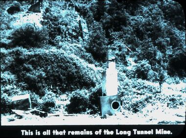
Slide - DIGGERS & MINING. DIGGERS AND MINERS, 1900s
Diggers & Mining. Diggers and Miners. This is all that remains of the Long Tunnel Mine. The photo shows a tunnel on the right of picture and possibly another in the top left corner there are 2 man made structures, the front one appears to be a chimney. Markings: 35 994.5 WAL. Used as a teaching aid.hanimounteducation, tertiary, goldfields -
 Kiewa Valley Historical Society
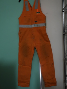
Clothes - Workmen - overalls and coat
Work clothes are made of durable fabric and the reflective tape enables it to be safe day and night. McConnell Dowell construcion company: Remote resources and energy projects - building, civil, electrical, fabrication, marine, mechanics, pipelines, rail, tunnel and underground construction. Founded in New Zealand in 1961. In 2003 it became wholly owned subsidiary of Aveng (Sth Africa). It expanded to Australia, Asia and the Middle East in he 1970s. Bogong Power Development consisting of tunnels and shafts and the construction of a new underground Hydro Electric Hydro Electric Power Station. It is the largest Hydro Power project constructed in Australia in 25 years.Bogong Power Development created a new power station extending the Kiewa Hydro Electric Scheme and increasing the generation of renewable energy.1. Overalls: Bright orange cotton gabardine overalls with 6 heavy duty studs down the front and retro reflective tape. Straps over the shoulders. The back has a large pocket sewn dividing it into 2 compartments. The front has 2 side pockets at the hip and 2 pockets at the chest. 2. Coat: Reversible red/grey coat. Sleeveless zip at the front. Pockets on each side of each layer - zip on one side and zipless on the other of each side. Waterproof grey material on one side and red warm materialo on the other. Sewn patches on the outside ".92R Yakka" "McConnell/Dowell/Bogong Power/ Development/ Safety Award/ 1 year/ 250,000" in white and green and on the grey side. "Aurora Australia/ picture/ Tunnel Boring machine"1. Black texta print 'Wiffen' and washing instructions label. workman's clothes, bogong power development, mcconnell dowell, high visibility garment -
 RSL Victoria - Anzac House Reference Library and Memorabilia Collection
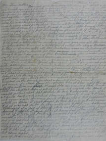
Letter of Edward William Earl, Edward William Earl, 3rd June 1917
Earl's letter to his mother, dated 3rd June 1917, tells of the ordeal of being trapped in a mine for forty three hours at Hill 60 on the Western Front. In his letter, Earl states his belief that it was only because of Sgt Alexander Hood that a rescue attempt was undertaken. Earl died of disease the following month (July 1917). Alexander Hood was killed in action on 31st October 1917. Earl's brother, Stewart Leigh Earl ( 2404 - 46th Battalion), served and survived. Double-sided one page handwritten letter of Edward Earl (3597 - 4 Tunnelling Company, Headquarters 1).ww1, western front, hill 60, edward william earl, 4 tunnelling company, alexander hood -
 Bendigo Historical Society Inc.
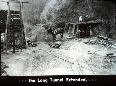
Slide - DIGGERS & MINING. DIGGERS AND MINERS, c1930s-1940
Diggers & Mining. Diggers and Miners. . . . The Long Tunnel Extended, . . . Markings: 36 994.5 WAL. Used as a teaching aid.hanimounteducation, tertiary, goldfields -
 Coal Creek Community Park & Museum
Mine Map, 21/01/1945
6298.1 - Map of Coal Creek mine tunnels, coal seams, boreholes, as well as roads and coal leura creeks. -
 Victorian Interpretive Projects Inc.
Book, Mining Mud and Medals
Hard covered book on the members of the Australian Tunneling Corp from the Ballarat Electorate during World War One. mining mud and medals, tunellers, australian mining corp, michael taffe, yvon davis, clare gervasoni -
Whitehorse Historical Society Inc.
Article, The Drill to protect valley, 2005
First of four road-headers started drilling at Mitcham Road end of Mullum Mullum Valley tunnel, with photo.First of four road-headers started drilling at Mitcham Road end of Mullum Mullum Valley tunnel, with photo.First of four road-headers started drilling at Mitcham Road end of Mullum Mullum Valley tunnel, with photo.mitcham road, mitcham, eastlink, mullum mullum valley, aubrey, chris, batchelor, peter -
 Stawell Historical Society Inc
Photograph, Amalgamated Scotchmans Mine Workings Stawell
Black and white photograph of Amalgamated Scotchman Mine workings Stawell. Western Mining Operations - because the wooden props have been immersed in water for a century they are well preserved. Underground view down mine shaft or tunnel showing timbers holding rock walls. This photograph is in a brown cover.stawell -
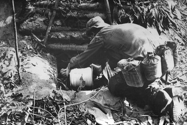 National Vietnam Veterans Museum (NVVM)
Photograph, Gibbons, Denis, Tunnel Rats
Denis Gibbons (1937 – 2011) Trained with the Australian Army, before travelling to Vietnam in January 1966, Denis stayed with the 1st Australian Task Force in Nui Dat working as a photographer. For almost five years Gibbons toured with nine Australian infantry battalions, posting compelling war images from within many combat zones before being flown out in late November 1970 after sustaining injuries. The images held within the National Vietnam Veterans Museum make up the Gibbons Collection. A black and white photograph of Engineer 'Tunnel Rats' prepare to enter a NVA/VietCong bunker complex, and its connecting tunnels to check the underground area for enemy, prior to blowing up the complex North West of the 1st Australian Task Force Base, Nui Dat, Phuoc Tuy Province.photograph, tunnel rats, nva/vc, 1st atf base, nui dat, gibbons collection catalogue, engineers, nva viet cong, phuoc tuy province, denis gibbons -
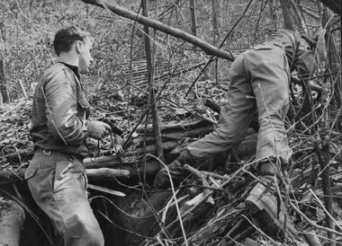 National Vietnam Veterans Museum (NVVM)
Photograph, Gibbons, Denis, Tunnel Rats
Denis Gibbons (1937 – 2011) Trained with the Australian Army, before travelling to Vietnam in January 1966, Denis stayed with the 1st Australian Task Force in Nui Dat working as a photographer. For almost five years Gibbons toured with nine Australian infantry battalions, posting compelling war images from within many combat zones before being flown out in late November 1970 after sustaining injuries. The images held within the National Vietnam Veterans Museum make up the Gibbons Collection. A black and white photograph of Engineer 'Tunnel Rats' prepare to blow a NVA/VietCong bunker complex and its connecting tunnels, and at the same time seed the underground area with C.S, gas crystals North West of the 1st Australian Task Force Base, Nui Dat, Phuoc Tuy Province.photograph, 1st atf base, nui dat, tunnel rats, nva/vc, gibbons collection catalogue, engineers, c s gas, nva viet cong, phuoc tuy province, denis gibbons -
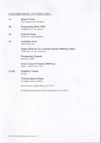 Bendigo Historical Society Inc.
Document - VICTORIA HILL - FURTHER SIGNS, VICTORIA HILL
Handwritten carbon copy, and later typed copy, of a list of further signs for Victoria Hill. Signs include Quartz Veins, Prospecting Shaft, 1929, Concrete Dam, Anticlinal Arch New Chum Line, Engine Beds for Gt Central Victoria (Midway Mine), Prospecting Tunnels, Primitive Tunnel. Notes at the end: Given to Geo & Max Ellis on 31/3/1971 and Prospecting tunnels driven from small Open Cut in 1860's. Notes prepared by Albert Richardson.document, memo, victoria hill, victoria hill, further signs victoria hill, new chum line, gt central victoria (midway mine), victoria quartz, davis, geo ellis, max ellis -
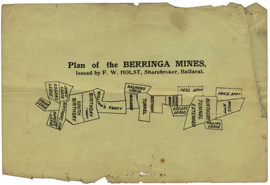 Federation University Historical Collection
Plan, Plan of the Berringa Mines
Small printed plan of the of the Berringa Mines, including Price Application, Collins Lease, Birthday Tunnel Extended, Peel Application, Edgar's Lease, Birthday Tunnel North, Kangaroo, William's Fancy, Birthday, South Birthday, Bunge's Lease, Jones' Lease, Verso is an advertisement of r Ballarat Hardware Co.berringa mines, price application, collins lease, birthday tunnel extended, peel application, edgar's lease, birthday tunnel north, kangaroo, william's fancy, birthday, south birthday, bunge's lease, jones' lease, ballarat hardware co. f.w holst, stockbrokers, cgt -
Whitehorse Historical Society Inc.
Article, Crossing work starts, 2003
Article on grade separation at Middleborough Road railway crossing; with items on maintaining tunnel design in proposed Mitcham Frankston Freeway.Article on grade separation at Middleborough Road railway crossing; with items on maintaining tunnel design in proposed Mitcham Frankston Freeway.Article on grade separation at Middleborough Road railway crossing; with items on maintaining tunnel design in proposed Mitcham Frankston Freeway.eastern freeway extension, railway crossings, middleborough road, blackburn, laburnum railway station -
Whitehorse Historical Society Inc.
Article, Giant digger takes first bite of our new tunnel, 2005
Article on the digging of the Eastlink tunnel through the Mullum Mullum Valley, and political controversy over road tolls.Article on the digging of the Eastlink tunnel through the Mullum Mullum Valley, and political controversy over road tolls. Photo of worksiteArticle on the digging of the Eastlink tunnel through the Mullum Mullum Valley, and political controversy over road tolls. east link eastern freeway extension, tunnel -
 Ringwood and District Historical Society
Photographs, 1979-80 MMBW pipe line project at Hubbard Reserve, North Ringwood � compressor
Part of a 43-photo record of the MMBW�s engineering feat in drilling a 12 inch pipe line up to 40 feet deep through rock hardened by volcanic action associated with geological fault that occurs along the line. The work took place from October 1979 to May 1980 on the southern boundary of Hubbard Reserve, North Ringwood. The collection was presented to the Ringwood Historical Research Group by J Clarke on 9th June 1980.E561 N6 Feb 1980 A43 Compressor of the tunnelling gang on the sewer line in Burlock Ave -
Clunes Museum
Document, 1875, 1876,1878
.1 Green page headed "Yankee Tunnel" showing dates and depths dug and depths of tunnel costings on reverse of page, calculations in centre .2 Blue page dated 14 January 1876 headed "Tunnel" showing costings, amount sold, on the reverse shows 1875 dividents with amounts. Also a lost of names and amounts (these have been crossed through) .3 Cream coloured card with 1948 calendar printed on it .4 Memo from Clunes Water Supply dated 6 May 1878 detailing cost of laying on water; Memo addressed to Messrs Hudson's & Sons, Paddock. .5 Blue page dated 21.4/1877 headed "Tunnel" showing costings, amount sold.yankee tunnel, gold mine costings -
 National Vietnam Veterans Museum (NVVM)
Photograph, Gibbons, Denis, Tunnel Rat
Denis Gibbons (1937 – 2011) Trained with the Australian Army, before travelling to Vietnam in January 1966, Denis stayed with the 1st Australian Task Force in Nui Dat working as a photographer. For almost five years Gibbons toured with nine Australian infantry battalions, posting compelling war images from within many combat zones before being flown out in late November 1970 after sustaining injuries. The images held within the National Vietnam Veterans Museum make up the Gibbons Collection. A black and white photograph of an Engineer 'Tunnel Rat' wearing a flack jacket enters a tunnel found leading into the Long Hai Hills during land and mine clearance operations in July 1969. The Engineers were under the protection of D coy 6 RAR/NZ (ANZAC), artillery, Mortar and Naval gunfire.photograph, tunnel rats, d coy, long hai hills, gibbons collection catalogue, artillery, mortars, gunfire, engineers, 6 rar/nz (anzac), denis gibbons -
Port Melbourne Historical & Preservation Society
Photograph - Council workers, Kenny Hall and Robin Donchi Snr, Port Melbourne, 1980s
Probably taken in the 1980sKenny Hall and Robin Donchi Senior near Liardet and Pickles Streets digging test holes for a tunnel under Cruickshank Street.engineering - roads streets lanes and footpaths, robin donchi snr, ken hall -
 Coal Creek Community Park & Museum
Farmed Mine Map, Map Of Underground Workings of Coal Creek Mine, 1896
8515.1 - Map of underground tunnels at a coal creek mine. Frame has a paper label rotted and faded almost beyond legibility. -
 Bendigo Historical Society Inc.
Photograph - AUSTIN COLLECTION:TWO MEN IN TUNNEL
Black and white photo: Colin Campbell,mine engineer and Clive McNamara,miner, in mine tunnel at Central Deborah Goldmine,Bendigo.mining, business, central deborah gold mine -
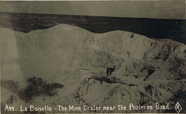 Bendigo Historical Society Inc.
Postcard - ACC LOCK COLLECTION: LA BOISELLE - THE MINE CRATER NEAR THE POZIERES ROAD, POSTCARD, BRITISH MADE, 1914-1918
Postcard, WW1, B&W image of a mine crater at Boiselle near the Pozieres Road. Timbers and a figure in front of a tunnel openingpostcard, postcard, ww1, france, la boiselle, mine crater, pozieres -
 Bendigo Historical Society Inc.
Photograph - Victoria Hill, Bendigo, 1973
Gold was discovered on Victoria Hill in 1854 and by 1861, 1,200,000 ounces of gold had been extracted from the site. The first claim was bought for 80 pounds by Prussian immigrant Christopher Ballerstedt and his son Theodore. Christopher Ballerstedt was nicknamed the "Father of the Hill" and was the first to prove that gold reefs extended below the surface. His 200-foot plus mine shafts yielded quartz rich with gold, inspired other miners, and were instrumental in Bendigo becoming the world's deepest and richest goldfield. The site still features relics of nineteenth century mining including quartz crushing machinery and the foundations of George Lansell’s 180 mine. These features are characteristic of Bendigo’s mining history and represent two prominent nineteenth century miners, Christopher Ballerstedt and George Lansell, who held important roles in the development of Bendigo. Victoria Hill Quartz Gold Mines are registered as a site of significance. The site is of historical, archaeological and scientific importance to Victoria. The mines represent the symbolic heart of Bendigo’s gold mining history and the importance that mining played in wealth creation and the development of Victoria. The diggings reserve is accessed from the rear of Albert Richardson Reserve located at 40-56 Marong Road, Ironbark. The site has steep and unformed paths and is closed to the public at dusk. It is important to stay to the paths to avoid the diggings. Interpretive signs help visitors to appreciate the importance of the site and the remaining relics of Bendigo’s mining history.Victoria Hill Ironbark, Bendigo. Photos of the poppet head, sand heap, tailings, shafts and tunnels. Before development into a tourist attraction.history, bendigo, victoria hill, ironbark, diggings -
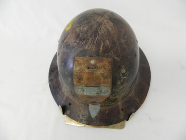 Kiewa Valley Historical Society
Helmet Safety, circa mid to late 1960's
This helmet worn by SEC Victoria workers in the Kiewa Hydro Electricity Scheme is a mandatory safety requirement by all personnel employed by government and statutory agencies who worked on or around "dangerous" apparatus or underground location sites. This type of pressed fibre helmet was later superseded by moulded plastic helmets. The start of the project (late 1940's) was not greatly covered by later introduced health and safety regulations. This has been demonstrated by photos of workmen outside using heavy machinery and other apparatus, see KVHS 0396, KVHS 0405 and KVHS 0392. However in the tunnels and underground safety helmets were mandatory, see KVHS 0403.This safety helmet was used by workers during construction of the generators and tunnels of the Kiewa Hydro Scheme was issued once only to each worker during his employment covering the 1940's to 1960's period. The attitude to health and safety during this period, can be summed up by this "initiation" ritual. When the helmet had been instrumental in saving a bad accident to a worker, that worker would be "invested" into the "Turtle Club". Although a safety helmet was only issued once to a worker this changed when modern moulded plastic helmets and greater Health and Safety requirements were introduced. Helmets now are replaced bi-annually.This safety helmet is made from pressed fibres with eyelets for airflow to the head. On the base of the helmet (before the rim) are 15 metal eyelets and three quarters up are six other eyelets (3 on each side). A thick leather strap is fastened by two rivettes to the main helmet. This strap has a metal bar rivetted on to affix a "safety" lamp, for underground work (Tunneling). There are two additional metal prongs and a metal bar to secure the lamp on the rim of the front of the helmet.sec vic kiewa hydro scheme, alternate energy supplies, alpine population growth -
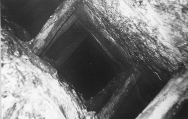
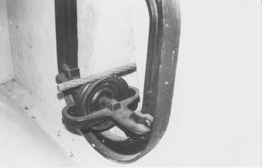 Melbourne Tram Museum
Photograph - Display of cable tunnel yoke, tunnel shape, cable and supporting pulley, N Williams
Photograph shows cable tunnel yoke, tunnel shape, cable and supporting pulley. K McCarthy collection.Yields information about cable tram tunnel componentsBlack and white photograph with note on rearIn ink "27" and "K McC"cable trams, yoke, cable, rope, pulley -
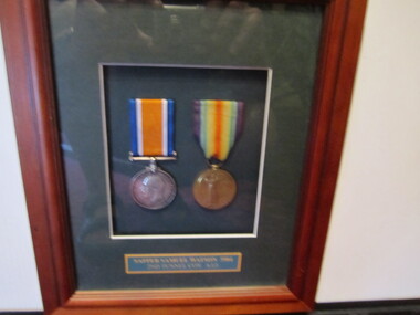 Ballarat RSL Sub-Branch Inc.
Medals - Framed 2 x WW1
"Sapper Samuel WATSON 3904 2nd TUNNEL COY AIF" British War Medal & Victory Medalmedals, ballarat rsl, ballarat -
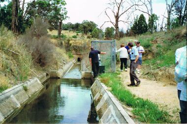 Bendigo Historical Society Inc.
Photograph - COLIBAN CHANNEL
Colour photo. Image shows channel to Castlemaine and tunnel, just after leaving Coiliban main Channel. 'Tracking the Coliban Main Channel' Bendigo Historical Society Inc., excursion 5th. December, 2009, organised by Phil Wilkin, member. John Kelly and Ray Smith in image., others unknown. Concrete lined channel, with tunnel in background.cottage, miners, coliban, channel, castlemaine, tunnel